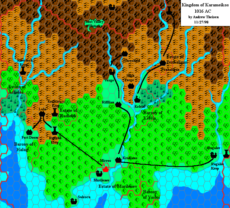
I've used a style as similar as possible to Thorf's one for the map. ;)
First the map, then some explanations:

http://www.gruppoludico.it/naga/Karameikos_northcentral_2.7m.png
I've incorporated in the map all the material of the B adventures, accordingly to the informations given in B1-9.
The B8 area has been put in the more favorable position "north of Threshold" (B1-9, which is the most recent source about the area - the original B8's suggested placement was instead west of Threshold): rather distant from large communities and in hilly hexes (it would have been rather difficult indeed to put the area in mountainous hexes). The trails from the B8 map have been connected to other logical spots in the map above. I think it could be reasonable to connect Tuma and The Manor with other Darokin features thought trails that cross the mountain range through showed mountain passes.
Moreover, I've assumed River Krevilan from B8 to be the same river that goes north from Eltan's Springs (from KKoA).
For the ferries farms in B10 I've used the "posthouse" symbol from GAZ12 - I've intended it to be any building smaller than a village (an isolated inn, farm, etc.) other than a keep, castle, etc. Obviously, the map isn't intended to show every single posthouse, farm of isolated inn, but only the more important (or known) ones.
The Windrush Lake's sizes have been reduced; according the measures given in KKoA, the lake would be over three 8-miles-hexes long in N-S direction, and over one in W-E direction. Becouse the lake couldn't be so large (it's not even showed in the GAZ1 map), I've reduced it to fit within a single 8-miles-hex.
You'll see borders of minor fiefdoms; I've assumed that the fiefdoms whose borders were not showed in GAZ1 map to be one 8-miles-hex or smaller in size.
Last but not least, I've tried to keep the Lost Valley of Hutaaka in the position where B10 puts it. So I've not moved it westward, as GAZ1 suggests. With some minor adjustments, I've managed to keep it within Karameikos without altering B10 too much.
Some sites of the map, in alphabetical order:
Armstead (Knosht): The 'Karameikan Armstead' mentioned in the Penhaligon Trilogy novels. It has been identified with Knosht, a village mentioned in GAZ5 (description of Boris Beerthumb - here it's only said to lay in the hills east of Threshold). So Armstead should be the Thyatian name of the village, Knosht the Traladaran one.
Ben Dalen Mountain: A mountain of the Cruth/Black Peaks range near Highforge, mentioned in the Book of Wondrous Inventions; gnomes have a mine near the mountain.
Black Woods, The: In the adventure suggestions given in D&D Expert Set (which are all set in Threshold or in the vicinity), there's one concerning Bargle's "secret army"; his mercenaries, disguised as trees, dwell in "The Black Woods" west of Threshold.
Blackstone Heath: An overgrown area south of Threshold, mentioned in one of the adventure ideas featured in D&D Expert Set; there a garbage dump with a black pudding will be built in the near future.
Byxata: The Hutaakan village in the Lost Valley, from B10.
Castle Mistamere: The dungeon from the group adventure in D&D Base Set, another hideout of Bargle. It was the seat of Gygar, a mage-lord of centuries ago. The castle is identifiable with a ruined Hutaakan town north of Threshold, on the lake's shore, mentioned by GAZ1; locals don't know its Hutaakan origin. Castle Mistamere was probably built over these ancient Hutaakan ruins, and the dog-headed statues that the PCs find in the first level of the castle probably aren't kobold statues (as the Base adventure suggests), but Hutaakan statues brought up from lowel levels by Gygar himself centuries ago.
Eltan's Springs: The small village in the mountains north of Threshold, from KKoA.
Elwyn's Sanctuary: The hideout of Elwyn 'the Ardent', from B9; according to B1-9 it should lay somewhere in the wilderness areas east of Threshold.
Haradraith's Keep: The castle of the "Queen" Ilyana (the evil half-sister of Lady Penhaligon), from B12.
Highdell: Mining village north of Threshold, from D&D Expert Set (see Threshold description here). From the adventure "Ransom", in Dungeon Magazine #42, we learn that a Sir Reynard has a fief north of Threshold. I've identified Highdell with the main village of Sir Reynard's fief.
Irenke: The adventurer's paradise described in Joshuan's Almanac; we know that it's found on a cart-road that goes west of Penhaligon for about ten miles, and then again joines the Duke's Road.
Lumm: An abandoned village from X12; the mad wizard Skarda kindnapped all the inhabitants twenty years before the adventure.
Manor, The: The keep of Lydrium Arkayz, from B8.
Old Antilles Castle: The more familiar Caldwell Keep, from B9 and B1-9; as it's only abandoned and not in ruins, I've used the 'keep' symbol.
Old caves: The small dungeon where the unnamed hero from D&D Base Set first encounters Bargle and Aleena.
Rock, The: The main adventure site of B8.
Ronkan: The Traldar village in the Lost Valley, from B10.
Stallanford: The village featured in the adventures B11 and B12; I've tried to stay true to its original position (the map in the abovementioned modules is largely inconsistent with GAZ1 map).
Temple of the Shield: An ancient temple of Halav dug in the mountainside, from the adventure Hail the Heroes; it was built shortly after the Time of the Dragonlord, and it's now abandoned, its location lost to common knowledge.
Tuma: The ancient city of Tuma, featured in B8; it's not in ruin (it pops in and out the Prime Plane from the planar prison where it has been put thousands of years ago), but "ruins" seemed the best symbol for it to me.
Utica: Small village found in the adventure "Ransom" (Dungeon Magazine #42); it's about ten miles north of Karameikos' borders.
Zadreth: An abandoned and ruined village laying on the eastern shores of Lake Windrush, according to the adventure Hail the Heroes. A trail, later paved by the Grand Duke, leads there from Threshold. An almost disappeared trail leads instead from Zadreth to the Temple of the Shield.
Some other sites:
Barkel Mountains, Forest of Carm, The Barrens, The Greenweald, Krayzen Mountains, River Krevilan, Lake Neshonan, River Neshonan, The Rendwood, Sylvanhome and The Western Bough are all from B8.
Cherkass, Gnomes' Ferry, Hokol, Ilyakana, Misha's Ferry, Sielo, Sukyskin and River Syreb are all from B10.
Lastly, the ancient village named Lugsid in the adventure Hail the Heroes should be identified with an old community laying on the site of the present Threshold town.
Well, I think that's all. I hope you like it.

I'm open to any suggestions in order to improve the map, add other details and make eventual corrections. ;)
P.S.: If you need, I can also post the map with the 8-miles-per-hex grid overlay. ;)
Two things:
1--I would like to see an 8mi overlay (out of habit, I've drawn a 24 mile overlay on all of my 8 mile maps, for quick reference when changing map scales (out of necesity and/or portability).
2--I disagree that the Ancient ruins and Castle Mistamere are seperate locales.
-The Ancient Ruins are Hutaakan ruins.
-Hutaakan society is lead by the Preistly caste.
-History is often skewed throughout time by way of myth and legend; thusly, it would not be difficult to believe that the Hutaakan Priest-King Gagyar later becomes the mighty wizard ruler of legend.
-Assuming that the introductory adventure is the PC's first adventure, and that the kobolds guarding the entrance are the PC's first encounter with the creatures, it would be enturely plausable that the adventurers would mistake the hutaakan (jackal-headed) statues on the first level as (dog-headed) kobolds.
-The location of the castle is described as "a short stroll past some local farmer's fields".
-All the farms around Threshold are north and west of the city, if Mistamere were to the south and east, they wouldn't have met any farmers, and would have taken quite a bit more time than a morning stroll (3 miles to the ruins vs. 9 miles to Zendrolion's Mistamere location).
-The map of Mistamere in the Basic DM's Book shows that the castle was built against and into the wall of the mountain--an architecture which B10 shows was common amongst the hutaakans.
Of course, it is up to the individual DM, but it is my presumption that the Ancient Ruins *is* Castle Mistamere.
Roger
Here's some possible additions:
The "Gnome-Kingdom of Highforge" has official boundaries on the K:KoA map
The "Elven-Kingdom of Radlebb" too
Also, isn't there also a reference to a separate "Elven-Kingdom of Rifflian"?
Isn't "Elwyn's Sanctuary" the official name for this map's "Iron Fortress".
I am of Roger's opinion on Castle Mistamere being the same as the Ancient Ruins north of town. It seems like the writers intended to hint that they were the same locale. Also, to pick nits isn't it referred to officially as "Castle Mistamere" instead of "Mistamere Castle"?
From the Expert Rules, there's "Blackstone Heath" (south, IIRC) of Threshold, where a black pudding is used as a municipal garbage disposal. Wouldn't heathland be the same hex as moorland?
Do any of the draconic realms from the Who's Who DRAGON magazine article overlap this area?
I wonder if all the DUNGEON magazine bits have been added? (http://pandius.com/prodlist.html). Zendrolion, if you're missing any Karameikan adventures, maybe someone with a copy could help out. For example, though I don't own a copy, according the description of "Tarfil's Tomb" http://www.pen-paper.net/rpgdb.php?op=showarticle&articleid=2346, its locales might lie within the frame of the map.
I like the inclusion of Tuma and its surroundings, yet wasn't Tuma supposed to be west of Threshold?
Lastly, I'd so much like to see the rest of Karameikos given this treatment too...
Shane
I seem to recall, from my own map of Tuma (which was in one of the threads here a while back, but I don't see on Shawn's page, so maybe he didn't put it up there- I'll have to send it on over to be posted on the Vaults), that the region shown in B8 is actually a bit larger than it would seem here on your map, but then, Tuma has always been kind of an 800 lb. gorilla in terms of trying to place it anywhere, so I kind of like what you've done with it. It fits better than where I was thinking of putting it, at least as you have blended them together here.
Also, I'm curious (and at work, so can't do the necessary research myself)- how do the dimensions of Windrush lake on this map mesh with the dimensions of the Expert set map of the Threshold region?
1) The pass gaps leading into Darokin on either side of the Krayzen mountains would seem to reduce the importance of the Duke's Road for trade.
2) Why is the land west of the Windrush at 100 feet in altitude? seems too low given the GAZ 1 height of the Wulfwolde and Cruth Lowlands.
-OldDawg
My only comments would echo OldDawg regarding the passes. One possible solution could be to insert some broken land hexes at the high points of the passes, not really mountainous areas but very rough and choppy terrain, and these would make it impossible for wagons or carts to traverse.
Again though, I love what you've done and hope you plan on some more!

I forgot to say that the reference year for the map is AC1000. ;)
And now for some answers:
1--I would like to see an 8mi overlay (out of habit, I've drawn a 24 mile overlay on all of my 8 mile maps, for quick reference when changing map scales (out of necesity and/or portability).
Here it is:

http://www.gruppoludico.it/naga/Karameikos_northcentral_2.7m_grid.PNG
2--I disagree that the Ancient ruins and Castle Mistamere are seperate locales.
Interesting theory, I'll probably follow it. However the Mistamere Castle still seems to have a medieval design, and to be not so old (a wooder door still rotting at the entrance, furniture, etc.). Could it be that Gygar, the mage-king of Mistamere, built his castle above or in the middle of the Hutaakan ruins? Perhaps the first level of the castle is only some centuries old, but the lower levels have an Hutaakan origin?

This way the dog-headed statues in the first leve of the castle could still be Hutaakan: Gygar would have picked them up from the lower levels. ;)
The "Gnome-Kingdom of Highforge" has official boundaries on the K:KoA map
The "Elven-Kingdom of Radlebb" too
Also, isn't there also a reference to a separate "Elven-Kingdom of Rifflian"?
I've checked KKoA, but none of these "kingdoms" has got any borders on the map. We could map them out anyway. Suggestions?
IMHO the Highforge Kingdom shouldn't control a large area; I think that the Gnome-King Dorfus Hilltopper holds authority over several gnomish communities that lay between Threshold and the Windrush and Hillfollow rivers. Perhaps we could we could mark out only the 2.7-miles-hexes around Highforge as his.
In regards to the elven clans, I don't think they have a "king". Each clan should have its clanmaster, and perhaps some areas (like Rifflian) are ruled by a council of the nearest elven clanmasters. Moreover, each clan seems to be rather small (100-200 people according to GAZ1). OTOH, if the map was set in AC1010 or in the following years, we could certainly have the borders of some elven dominions.
Isn't "Elwyn's Sanctuary" the official name for this map's "Iron Fortress".
You're right, but becouse as of AC1000 no one knows what happened to Elwyn, and no one knows to whom belongs the mysterious iron fortress that rose in the wilderness east of Threshold, I left the same as mysterious as possible. If you prefer, I could change it to "Elwyn's Sanctuary".
Also, to pick nits isn't it referred to officially as "Castle Mistamere" instead of "Mistamere Castle"?
Yes! I'll edit as soon as possible.
From the Expert Rules, there's "Blackstone Heath" (south, IIRC) of Threshold, where a black pudding is used as a municipal garbage disposal. Wouldn't heathland be the same hex as moorland?
I think this area is too small to feature on the map; perhaps it's part of the Threshold hex.
Do any of the draconic realms from the Who's Who DRAGON magazine article overlap this area?
IIRC, no.
I wonder if all the DUNGEON magazine bits have been added? (http://pandius.com/prodlist.html). Zendrolion, if you're missing any Karameikan adventures, maybe someone with a copy could help out. For example, though I don't own a copy, according the description of "Tarfil's Tomb" http://www.pen-paper.net/rpgdb.php?op=showarticle&articleid=2346, its locales might lie within the frame of the map.
I think to own all Mystara-related infos found on Dungeon Magazines; Tarfil's Tomb and Hrothgar's Resting Places are located in the eastermost and south-easternmost parts of The Moor, so they don't appear on the map.
I like the inclusion of Tuma and its surroundings, yet wasn't Tuma supposed to be west of Threshold?
That's what B8 says when suggesting where to position Tuma and its surroundings; however B1-9 suggests a position more or less "north" of Threshold. I've chosen the latter source becouse it's the more recent and becouse placing the B8 area in the Cruth Mountains west of Threshold would force me to change the terrain type of some hexes on the 8-miles-map of GAZ1.
Lastly, I'd so much like to see the rest of Karameikos given this treatment too...
Well, I plan a map with the same scale of eastern Karameikos in the near future. ;)
I seem to recall, from my own map of Tuma (which was in one of the threads here a while back, but I don't see on Shawn's page, so maybe he didn't put it up there- I'll have to send it on over to be posted on the Vaults), that the region shown in B8 is actually a bit larger than it would seem here on your map, but then, Tuma has always been kind of an 800 lb. gorilla in terms of trying to place it anywhere, so I kind of like what you've done with it. It fits better than where I was thinking of putting it, at least as you have blended them together here.
The area showed on B8 map seems to be about three hexes long in W-E direction and 1.75 hexes high in N-S direction; I think these sizes are more or less the same in the map I've posted. The only other possibility, as Shane suggested, would be to place the whole Tuma area north-west of Threshold (as B8 says), where the Achelos River flows down of the Cruth Mountains, but this way we'll have to change the terrain type of some hexes, as I said.
Also, I'm curious (and at work, so can't do the necessary research myself)- how do the dimensions of Windrush lake on this map mesh with the dimensions of the Expert set map of the Threshold region?
I think the Threshold map in D&D Expert Set, which only shows some hundreds feet of land around the town, is too small to make a comparison with KKoA map. The portion of the Windrush Lake visible in the Expert Set map is also too small to assess if its shape is different from that of the KKoA map (BTW, from what is visible they seem to match :P ).
1) The pass gaps leading into Darokin on either side of the Krayzen mountains would seem to reduce the importance of the Duke's Road for trade.
I don't think so. GAZ11 says that the Cruth/Black Peaks range is filled with treacherous mountain passes and that the range is passable with the aid of an experienced guide; the description of the Armstead village in GAZ11 also says that it is only a "short trip" distant from Threshold. Moreover, having mountain passes doesn't mean that they're all used by lots of merchants and travelers. For example, the passes that lead north from Tuma and The Manor have not probably been used for centuries and probably are not so easy to pass through.
According to "Ransom" adventure in Dungeon Magazine #42 the Armstead-Threshold pass seems plagued by bandits, so it neither a good choice for a merchant caravan. Anyway, orcs and goblins could plague these minor passes, and without the protection offered by Duke's Road Keep I suppose that only adventurers and smugglers would choose these minor passes to get into or out from Karameikos.
Nevertheless, the Duke's Road - which is a paved road, don't forget it - is kept free of bandits and monsters, and in addition leads to the great market city of Selenica, where trade is supposedly more profitable than in Armstead.
2) Why is the land west of the Windrush at 100 feet in altitude? seems too low given the GAZ 1 height of the Wulfwolde and Cruth Lowlands.
Right! I left a zero home... 1,000 feet is the correct altitude. Edited! ;)
1) The pass gaps leading into Darokin on either side of the Krayzen mountains would seem to reduce the importance of the Duke's Road for trade.
I don't know- that land is still largely wilderness, and wouldn't be nearly as well patrolled (or maintained) as the Duke's Road. They might also be a lot more treacherous than they appear at this scale.
Additionally, there is the possibility that they are in regions nominally controlled by others, who would have their own ability to tax and control trade through the region. In particular, the area near Armstead, IIRC, is a Borderland Region (in Darokin), and the magistrate might be incredibly tightfisted, hence why the Duke's Road goes towards Selenica instead (and of course, Selenica is a major trade city, and at the junction of Ylaruam, Karameikos, and Darokin). The lord of Highdell also would have some degree of ability to tax his territory (even if he owes the Duke some percentage in tax), and we all know how well Duke Stefan is able to exercise control over distant holdings that owe him fealty (*cough*Black Eagle*cough*)
Lastly, the region around Tuma would be far from ideal territory to send any kind of road through. For one thing, there are the Barrens and that blasted desert region south of Tuma. Then there is the haunted city of Tuma itself, and the fey inhabited woods, etc.
Roger
The area showed on B8 map seems to be about three hexes long in W-E direction and 1.75 hexes high in N-S direction; I think these sizes are more or less the same in the map I've posted. The only other possibility, as Shane suggested, would be to place the whole Tuma area north-west of Threshold (as B8 says), where the Achelos River flows down of the Cruth Mountains, but this way we'll have to change the terrain type of some hexes, as I said.
Seeing the 8 mile overlay puts it in more perspective, but it still seems a bit off to me; of course, I may have gotten the scale wrong when I put my own map together (seems to me the hexes there were at 1 or 2 miles per square or so, IIRC.)
(BTW, I found that thread, and had forgotten I put the map on my own website. Anyway, if anyone is curious, here's a large and small scale version of the Tuma map that I made up a few years back: Arnold Says: It's not a Tuma!)
I've checked KKoA, but none of these "kingdoms" has got any borders on the map
I don't have my Mystara library anymore, but I'm pretty sure I've seen an official drawing of the Gnome-Kingdom of Highforge's boundaries somewhere. Maybe I'm misremembering.
In regards to the elven clans, I don't think they have a "king".
You're right, the official names for the elven polities are something like the "Elven-Estate of Radlebb" and the "Elven-Estate of Rifflian" (also ones for Vyalia and Achelos: Andrew's map here shows Radlebb and Achelos). I'm pretty sure that there is some place...maybe it's in the almanacs, that lays out when certain Elven-Estates were officially established. I also remember being surprised at the mention of an official Elven-Estate for tiny Rifflian (this one may've been only mentioned in text, and not made it onto a map). Am I misremembering this?
Perhaps you could mark the rapids near the headwaters of the Foamfire River, and the waterfall at the entrance to the Lost Valley?
Isn't there also a waterfall along the path to Eltan's Spring?
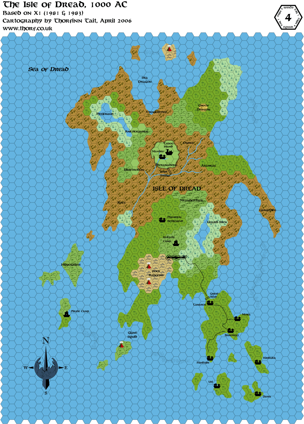
The large bridge to Hutaaka valley could be shown like the one on the Isle of Dread map here.
You're right, but becouse as of AC1000 no one knows what happened to Elwyn, and no one knows to whom belongs the mysterious iron fortress that rose in the wilderness east of Threshold, I left the same as mysterious as possible. If you prefer, I could change it to "Elwyn's Sanctuary".
The same could be said about the Lost Valley of Hutaaka or Haven. If a players map of Karameikos were made, then it would be appropriate to obscure the place names based on in-character knowledge.
I think this area (Blackstone Heath) is too small to feature on the map; perhaps it's part of the Threshold hex.
True, but the same could be said about the Black Woods, the Old Caves, or Caldwell's Castle, but it's neat to see those obscure places on the map. There could be one moorland hex (Blackstone Heath) just west of where "Mistamere Castle" is placed, and with a tower symbol (maybe the tower itself is called "Blackstone Tower"?). In that Expert Set paragraph, is it called a tower, keep, or what?
Speaking of Caldwell's Castle, is the name "Old Antilles Castle" used in the text? If it isn't, then "Caldwell's Castle" might be better. If it is, then parentheses "Old Antilles Castle (Caldwell's Castle)" might be best (doesn't Caldwell buy the castle around AC1000?)
Also, wasn't there another adventure in B9: Castle Caldwell and Beyond that was cut out for the B1-9 compilation?. If so, is there any indication of where it takes place relative to the other adventure?
The only other possibility, as Shane suggested, would be to place the whole Tuma area north-west of Threshold (as B8 says), where the Achelos River flows down of the Cruth Mountains, but this way we'll have to change the terrain type of some hexes, as I said.
I do like how you portrayed the problematic Tuma area. Just to mention some other factors: another problem with using the Achelos River, is that the Caverns of Quasqueton from B1 are located where the river comes out of the mountains, so it might be too close to pack in another adventure site. Another option would be to slightly modify the shape of the Gustos or Magos rivers to fit the Krevilan River (though much of the surrounding terrain hexes would need to be changed - possibly into a Lost Valley of Hutaaka-style valley surrounded by mountains). Another option I've heard is to use the area in southern Darokin east of Hendry (here) which has rivers (Greyhare = Krevilan) and hills similar in shape to the B8 setting. Problems with this placement is that it'd be best to keep all the Basic adventures in Karameikos (except for Cynidicea), and not have so far for the PCs to travel through wilderness, mountains, and the Five Shires just to reach the B8 adventure site. I'm not sure what to do about this, just sifting through ideas. Like I said, your solution looks pretty good.
The portion of the Windrush Lake visible in the Expert Set map is also too small to assess if its shape is different from that of the KKoA map
What about using the B10 map of Foamfire Valley here for the size and shape of the lake compared to Threshold?
Shane
I don't have my Mystara library anymore, but I'm pretty sure I've seen an official drawing of the Gnome-Kingdom of Highforge's boundaries somewhere. Maybe I'm misremembering.
Maybe in the original Expert set? (Not the Mentzer version, but the Moldvay/Cook version). I know it had some maps of gnomish tunnels and such.
Speaking of Caldwell's Castle, is the name "Old Antilles Castle" used in the text? If it isn't, then "Caldwell's Castle" might be better. If it is, then parentheses "Old Antilles Castle (Caldwell's Castle)" might be best (doesn't Caldwell buy the castle around AC1000?)
Technically, I think that's right. With the setting of all the B adventures in the 1000 AC/Gaz1 era with "B1-9: In Search of Adventure", I think that works. It would definitely be between 1000 and 1010, when Clifton Caldwell dies (according to PWA 1011, he died the previous year).
Also, wasn't there another adventure in B9: Castle Caldwell and Beyond that was cut out for the B1-9 compilation?. If so, is there any indication of where it takes place relative to the other adventure?
If you mean 'The Abduction of Princess Sylvia', I don't think it really fits in the Known World (on account of her being a princess). The only kingdoms that it might fit into in the Known World might be- Vestland (she could be a daughter of King Harald Gudmundsen), Ostland (possibly one of the thralls that are adopted "children"/hostages in King Hord Dark-Eyes' court), Ylaruam (maybe change the title princess to accomodate a sheik or emir's daughter or something). With a little stretching, I guess you could fit it anywhere (one of the Golden Khan's daughters, a daughter of one of the Princes/Princesses of Glantri, etc.), but as is, it doesn't really fit in.
Perhaps you could mark the rapids near the headwaters of the Foamfire River, and the waterfall at the entrance to the Lost Valley?
Of course I can!
I'll wait a while to further edit the map, so that I can make all corrections at the same time.Seeing the 8 mile overlay puts it in more perspective, but it still seems a bit off to me; of course, I may have gotten the scale wrong when I put my own map together (seems to me the hexes there were at 1 or 2 miles per square or so, IIRC.)
I've seen your take on the whole Tuma thing; this is my approach. Each square of the B8 map is only a half-mile large, so I portraied the overlaid 8-miles-hexes over it as you can seen in the linked map.
Isn't there also a waterfall along the path to Eltan's Spring?
The large bridge to Hutaaka valley could be shown like the one on the Isle of Dread map here.
Perhaps I could insert a tag like "Gateway to Hutaaka" in the map, in the point where the Foamfire approaches the valley's borders.
About Eltan's Springs IIRC the fall is found along the way from the village to the druid's grove, and I think it's really too small to appear on the map. ;)
The same could be said about the Lost Valley of Hutaaka or Haven. If a players map of Karameikos were made, then it would be appropriate to obscure the place names based on in-character knowledge.
Well, right. I'll change that name.
True, but the same could be said about the Black Woods, the Old Caves, or Caldwell's Castle, but it's neat to see those obscure places on the map. There could be one moorland hex (Blackstone Heath) just west of where "Mistamere Castle" is placed, and with a tower symbol (maybe the tower itself is called "Blackstone Tower"?). In that Expert Set paragraph, is it called a tower, keep, or what?
The Expert Set's passage about Blackstone Heath is the following:
Blackstone Heath: In an overgrown field south of town, a new building has been constructed of black stone. Guards at the entrance suggest that information is available at the Town Hall. The local officials smile proudly and explain that it’s the new garbage dump, soon to be opened to the public, and licensed to the head of the Magic-User’s Guild (the person who trains all magic-user characters)!
I don't think Threshold's mayor (or Baron Halaran) would build a garbage dump 4 or more miles away from the town's outskirts, it seems a little unpratical to me. Moreover, if the distance of the dump from the town was that, the Blackstone Heath could well lay in wooded hills south-west of Threshold - crossed by the paved road (which would be used to carry the garbage from the town).
Nevertheless, I can still add this feature if consensus go this way. ;)
Speaking of Caldwell's Castle, is the name "Old Antilles Castle" used in the text? If it isn't, then "Caldwell's Castle" might be better. If it is, then parentheses "Old Antilles Castle (Caldwell's Castle)" might be best (doesn't Caldwell buy the castle around AC1000?)
The name "Old Antilles Castle" is found in the B1-9. Until Clifton buys the castle (AC1000 or more), it should still be known ad Old Antilles one, so I'll leave the old name. I'll not adopt the parentheses solution becouse that way I'll have to change also Haradraith's Keep in "Haradraith's Keep (Ilyana Keep)". The name of the castle is known, the fact that it'll be the castle of the B9 adventure will be specified in the legend.
Also, wasn't there another adventure in B9: Castle Caldwell and Beyond that was cut out for the B1-9 compilation?. If so, is there any indication of where it takes place relative to the other adventure?
As Cthulhudrew said, that adventure was "Abduction of Princess Sylvia", but it's difficult to place it in Karameikos or the present (AC1000) of the KW. IIRC, Agathokles on the Italian MMB suggested that the adventure could be set in the past of Darokin, in the age between the fall of the kingdom (AC723) and the rise of the republic (AC927); Sylvia would be the daughter of one of the lordlings that ruled parts of Darokin in that age.
Another option I've heard is to use the area in southern Darokin east of Hendry (here) which has rivers (Greyhare = Krevilan) and hills similar in shape to the B8 setting. Problems with this placement is that it'd be best to keep all the Basic adventures in Karameikos (except for Cynidicea), and not have so far for the PCs to travel through wilderness, mountains, and the Five Shires just to reach the B8 adventure site. I'm not sure what to do about this, just sifting through ideas. Like I said, your solution looks pretty good.
Yes, as you said I also prefer to keep B8 in Karameikos; moreover, I'd rather give precedence to B1-9, which is the more recent of the "old" B modules.
What about using the B10 map of Foamfire Valley here for the size and shape of the lake compared to Threshold?
That'd be another possibility, but I choose to ignore it becouse B10 map is largely different from GAZ1 map, and even Threshold position in GAZ1 is different from the town's location in B10 map. So the shape of the lake is also different in the latter, becouse there it had been adapted to the shape of the Black Peaks Mountains. I still prefer the shape suggested by KKoA, even if the scale is wrong. ;)
I don't think Threshold's mayor (or Baron Halaran) would build a garbage dump 4 or more miles away from the town's outskirts, it seems a little unpratical to me. Moreover, if the distance of the dump from the town was that, the Blackstone Heath could well lay in wooded hills south-west of Threshold - crossed by the paved road (which would be used to carry the garbage from the town).
Yes, you're right, Blackstone Heath should be closer to Threshold. And I see that it may not show up on the scale of this map. The only way I could see it showing up at this scale would be if "Blackstone Heath" is a landscape feature that extends beyond just a small area near the town's southern walls. In this case there'd be a relatively large area (e.g. one hex) directly south or southwest of Threshold of heathland with the name "Blackstone Heath". "Blackstone Heath" would be an area of upland heath where black stone is quarried (and used to build the garbage building), and would contain the "overgrown field" the garbage dump is built on. In any case there'd be no building symbol, since the garbage dump itself would be located in the Threshold hex, close to the town walls. What do you think?
I can accept the idea that Blackstone Heath is just a small feature that doesn't extend beyond (or show up on) the actual Threshold town hex, but I wanted to lay out some other ideas.
What is a "heath" anyway? And how does it differ from a moor/bog, marsh/swamp, and fen, represented by three different hex symbols? (Thorf's legend is here.) Here's the Websters definitions:
heath 1 a : a tract of wasteland b : an extensive area of rather level open uncultivated land usually with poor coarse soil, inferior drainage, and a surface rich in peat or peaty humus
moor 1 chiefly British : an expanse of open rolling infertile land
2 : a boggy area; especially : one that is peaty and dominated by grasses and sedges
bog : wet spongy ground; especially : a poorly drained usually acid area rich in accumulated plant material, frequently surrounding a body of open water, and having a characteristic flora (as of sedges, heaths, and sphagnum)
marsh : a tract of soft wet land usually characterized by monocotyledons (as grasses or cattails)
fen low land that is covered wholly or partly with water unless artificially drained and that usually has peaty alkaline soil and characteristic flora (as of sedges and reeds)
From these definitions, it seems that heath and moor are most similar, since both are peaty...that a heathland has heather shrubs instead of the grasses of a marsh...and is different from a fen since fens are specifically lowland features...and is drier than a bog, marsh, or fen.
I also found this webpage "What is a heath?", which states that a "heath" and "moor" are nearly identical. (Digression: on another webpage I came across a reference to "Blackmoor" ;):
Moorland dominated by heather (i.e. over 50% cover) is sometimes referred to as `black moor`, that with 25-50% cover as `grey moor` and that with less than 25% cover, including little or no heather, as `white moor`.
Shane
Shane
I've seen your take on the whole Tuma thing; this is my approach.
Zendrolion, I'd like to see this B8 map, but the link seems broken...I can't get the file to open.

Shane
In this case there'd be a relatively large area (e.g. one hex) directly south or southwest of Threshold of heathland with the name "Blackstone Heath". "Blackstone Heath" would be an area of upland heath where black stone is quarried (and used to build the garbage building), and would contain the "overgrown field" the garbage dump is built on. In any case there'd be no building symbol, since the garbage dump itself would be located in the Threshold hex, close to the town walls. What do you think?
I think that the solution you propose is rather good. I'll add a "moor" hex south-west of Threshold to indicate Blackstone Heath. ;)
The map is ready to be edited with the various proposed additions and the Hutaakan trails you mentioned. I'll edit it as soon as possible. Thank you all!
Zendrolion, I'd like to see this B8 map, but the link seems broken...I can't get the file to open.
I've fixed it. I hope it'll function now!
I've fixed it. I hope it'll function now!
Nope, it still doesn't work for me...when I click on it, a page of scrambled text appears. The other PNG files on your page open for me though.
Anyway, I'm looking forward to seeing your revised map of the Threshold region.
Shane
Nope, it still doesn't work for me...when I click on it, a page of scrambled text appears. The other PNG files on your page open for me though.
Worked for me.
Nope, it still doesn't work for me
Try clearing your cache or use another web browser. I had no problems with Firefox.
--Ray.
Try clearing your cache or use another web browser. I had no problems with Firefox.
--Ray.
That sounds like the problem we had with the Vaults a little while ago but Shawn did something that fixed it. I wonder why that happens?
I presume you went for 2.7 (2 2/3?) miles working up from 8 miles? any plans for 8/9 mile map (anyone?) - presumably at that level you'd want to show individual features rather than icons.
I like the idea, which seems to emerging here, of a whole series of linked scale maps - 2.7, 8, 24, 72 mile - to cover - selectively at first of course - Mystara.
On this - just pulled out B2 and checked the wilderness map on page 15 - which covers an area of 4000 x 5200 yards - 2.27 x 2.95 miles.
Maybe I should do a conversion onto 0.3 mile hex... (I won't be offended if someone beats me to it...)
Sorry this post got a bit rambly. Love the map though
Shane
I presume you went for 2.7 (2 2/3?) miles working up from 8 miles? any plans for 8/9 mile map (anyone?) - presumably at that level you'd want to show individual features rather than icons.
I like the idea, which seems to emerging here, of a whole series of linked scale maps - 2.7, 8, 24, 72 mile - to cover - selectively at first of course - Mystara.
I've made several 1 mile/hex maps of various regions, which is actually the format I prefer over the 2.7 (primarily due to it fitting with the Morlay/Malinbois map from PC4, as well as some other module maps).
I haven't read the trilogy yet, but I know that it depicts places such as Bywater, the Artisticles’ Red Granite Tower and the Three Suns Castle. Does anybody know where they (and the other new places mentioned in the books) should be placed on the map?
Has anybody read the Penhaligon Trilogy? I think it would be nice to add also some settlements described in these books.
I haven't read the trilogy yet, but I know that it depicts places such as Bywater, the Artisticles’ Red Granite Tower and the Three Suns Castle. Does anybody know where they (and the other new places mentioned in the books) should be placed on the map?
First of all, I really like this map! And the idea of getting every location from the modules marked on one map is something I have wanted to see for a long time, so thanks Zendrolion!
Bywater featured in both the Penhaligon Trilogy and in the module Escape from Thunder Rift is located to the south of the Highreach River, slightly west off the edge of the map. Aristicles' Red Granite Tower is located slightly further west of Bywater. I can check these details for exact locations later.
The Castle of the Three suns is located within Penhaligon.
The Penhaligon Trilogy also features another village, called Armstead which is located in Karameikos northeast of Threshold. It is not to be confused of the town of Armstead in Darokin. IMC I changed the Karameikos town to Bronow, which I figured to be its Traladaran name (IIRC Bron means weapon in Polish).
Håvard
First of all, I really like this map! And the idea of getting every location from the modules marked on one map is something I have wanted to see for a long time, so thanks Zendrolion!
I'm glad you liked it!
Bywater featured in both the Penhaligon Trilogy and in the module Escape from Thunder Rift is located to the south of the Highreach River, slightly west off the edge of the map.
IIRC Bywater from "Escape of Thunder Rift" is located along the Castellan River; I had placed it in the length of the Castellan River that flows from NE to SW.
The Penhaligon Trilogy also features another village, called Armstead which is located in Karameikos northeast of Threshold. It is not to be confused of the town of Armstead in Darokin. IMC I changed the Karameikos town to Bronow, which I figured to be its Traladaran name (IIRC Bron means weapon in Polish).
Interesting, but there isn't much room to the NE of Threshold; could Armstead/Bronow be located in the area around Knosht? Where else?
P.S.: I've finally edited the map. Now I'm awaiting your opinions about the placement of Bronow/Armstead. ;)
Interesting, but there isn't much room to the NE of Threshold; could Armstead/Bronow be located in the area around Knosht? Where else?
P.S.: I've finally edited the map. Now I'm awaiting your opinions about the placement of Bronow/Armstead. ;)
I think I placed it around where you placed Knosht. Perhaps you could just change the label to Knosht(Armstead)? We can easily ditch the name Bronow, since it was merely my suggestion to avoid confusion between the two Armsteads.
In my attempt to adapt the Penhaligon events to the canon timeline, I had Armstead start out as a small village, then gradually develop into a magical center of Karameikos, a sort of proto-School of Magecraft, before it is destroyed by Abelaats in AC1003. Penhaligon is destroyed the year thereafter, but is rebuilt by AC1010. Armstead remains a ruined place, quite possibly haunted, though a completely magic dead zone...
Maybe we could apply this to Knosht if we make it all the same village? It doesnt seem like there is much more written on Knosht?
Håvard
Shane
I think I placed it around where you placed Knosht. Perhaps you could just change the label to Knosht(Armstead)? We can easily ditch the name Bronow, since it was merely my suggestion to avoid confusion between the two Armsteads.
Yes, good idea: Armstead could be the Thyatian name, Knosht the Traladaran one - sort of Fort Doom (Halag)? ;)
Maybe we could apply this to Knosht if we make it all the same village? It doesnt seem like there is much more written on Knosht?
It's possible: OTOH the only thing we know about Knosht is that the village is the birthplace of Boris Beerthumb (from GAZ5), so it doesn't pose many problems.
Another possibility would be to move Knosht one or two hexes to the SW along the trail featured in the map, and place another village named "Armstead (Orazhievo)" (as Shane suggested
) about four or five hexes NE of it, still along the trail. I'm sure there is plenty of hamlets along these northern trails, so why not placing another village in this area?What do you prefer?
Yes, good idea: Armstead could be the Thyatian name, Knosht the Traladaran one - sort of Fort Doom (Halag)? ;)
Exactly!
It's possible: OTOH the only thing we know about Knosht is that the village is the birthplace of Boris Beerthumb (from GAZ5), so it doesn't pose many problems.
Another possibility would be to move Knosht one or two hexes to the SW along the trail featured in the map, and place another village named "Armstead (Orazhievo)" (as Shane suggested
What do you prefer?
I think both are fine. It depends whether you want as many locations as possible or whether you want to throw a few together in order to have a wider basis of information on that settlement.
Håvard
The thing that caught me most off guard is that I always thought the Firefoam Valley extended north from Threshold and not Verge (I apparently have been looking more at B10 than Gaz1 for longer than I realized). No big problem. I just have to adjust my thinking now, which is a good thing. I also never imagined Sukiskyn and the surrounding homesteads were that close to Kelvin. Again, B10 made them look much farther away.
Overall, fantastic job. :D
EDIT: Almost forgot to mention something in relation to the Castle Mistamere site: There is also that whole Lugsid/Zadreth issue from "Hail the Heroes" (I think) concerning the location of the Lost Temple of the Shield. I suppose it can be left up to individual DMs to decide if the ruins of Mistamere is the same as Lugsid or Zadreth or both or neither. Either way, if I remember right, the Lost Temple of the Shield is somewhere west of Threshold.
I've made several 1 mile/hex maps of various regions, which is actually the format I prefer over the 2.7 (primarily due to it fitting with the Morlay/Malinbois map from PC4, as well as some other module maps).
I agree that a series of 1-mile hex maps of Karameikos would be ideal. Karameikos is the entrypoint for the World of Mystara...it's the home of the Blue Box's Threshold, of the launching point for the first Expert adventure, of the first OD&D Gazetteer, and of the first AD&D Mystara boxed set...it is (or should be) the ultimate "Dominion of Adventure", with dungeons, keeps, wilderness lairs, and other adventure sites all over the place.
I am very much looking forward to Zendrolion's maps, which I hope will serve as a basis for a series of 1-mile hex maps of the country.
Shane
One minor nitpick though: I believe Cherkass should be moved one hex north. That puts it more in line with Hokol than Sukyskin.
I also think I understand why all those homesteads are closer to Kelvin than they are in B10 - it was probably the only way to get some other distances to fit. In any case, I'm happy to see a hill hex right across the river from Sielo as that has always been my traditional site for The Hill from B5 (and, incidentally, the site of the final battle between Halav and the Beastman King).
Time to revisit my Sielo Fort campaign and tweak with it some more to fit in the Barony of Kelvin now.
I agree with Andrew and Shane that a map in '1 hex = 1 mile' scale would be ideal, but with the present canonical degree of detail we should create and insert much many more features on a map with that scale, otherwise many hexes would stay empty. This is the reasoning behind my choice of the truly odd '1 hex = 2.7 miles' scale. ;)
EDIT: Almost forgot to mention something in relation to the Castle Mistamere site: There is also that whole Lugsid/Zadreth issue from "Hail the Heroes" (I think) concerning the location of the Lost Temple of the Shield. I suppose it can be left up to individual DMs to decide if the ruins of Mistamere is the same as Lugsid or Zadreth or both or neither. Either way, if I remember right, the Lost Temple of the Shield is somewhere west of Threshold.
Unfortunately I don't own "Hail the Heroes"...

Fkaftal, a friend of mine on the Italian MMB, suggested to put a "ruins" symbol somewhere (one or two hexes) east of Threshold, where the Lugsid/Zadreth site should lay. Any other ideas in reagar of this issue?
One minor nitpick though: I believe Cherkass should be moved one hex north. That puts it more in line with Hokol than Sukyskin.
Thank you, I'll give one more look at the B10 map. ;)
I also think I understand why all those homesteads are closer to Kelvin than they are in B10 - it was probably the only way to get some other distances to fit. In any case, I'm happy to see a hill hex right across the river from Sielo as that has always been my traditional site for The Hill from B5 (and, incidentally, the site of the final battle between Halav and the Beastman King).
Yes, the B10 map (and the Expert Set map) is sadly inconsistent with the GAZ1 map...
This explains why in my map some features of the B10 map have been twisted to fit with the GAZ1 map, such as the Foamfire Valley (and Lost Valley) and the positions of the Traladaran farms in the Sukyskin area.
Regarding The Hill from B5, I think that according to B1-9 the adventure should be placed somewhere around the source of Highreach River. In my campaign, I placed Guido's Fort along the Shrill River, an affluent of the Highreach that springs in the Haven area and runs north into the Highreach. This becouse in B1-9 the PCs arrive in Guido's Fort from Haven. ;)
Unfortunately I don't own "Hail the Heroes"...
Fkaftal, a friend of mine on the Italian MMB, suggested to put a "ruins" symbol somewhere (one or two hexes) east of Threshold, where the Lugsid/Zadreth site should lay. Any other ideas in reagar of this issue?
Damn. As fate would have it, I not only have this adventure, but have even used it IMC, but naturally I don't have it with me now...
I'm fairly convinced it's rather close to Threshold, though, because I seem to recall that the PCs were able to walk there on foot and back within a day. Well, actually they went back during the night, but that was because they had spent a lot of time exploring the ruins themselves.
But that's all from memory, so it's probably neither helpful nor reliable...
Thank you all again for the appreciations!
I agree with Andrew and Shane that a map in '1 hex = 1 mile' scale would be ideal, but with the present canonical degree of detail we should create and insert much many more features on a map with that scale, otherwise many hexes would stay empty. This is the reasoning behind my choice of the truly odd '1 hex = 2.7 miles' scale. ;)
I actually think a 1 mile/hex map would be overkill...and I usually indulge in (and enjoy) overkill in the planning stages of my campaigns. I can certainly see the attraction for some, but for me the 3 mile hex (okay...2.7) works well. Good detail without becoming obscene. Now if we were talking newly carved out dominions for the PCs, that would be fun, but for a whole nation...
Unfortunately I don't own "Hail the Heroes"...
Fkaftal, a friend of mine on the Italian MMB, suggested to put a "ruins" symbol somewhere (one or two hexes) east of Threshold, where the Lugsid/Zadreth site should lay. Any other ideas in reagar of this issue?
The trick here is that Hail the Heroes leaves the exact location up to the DMs. As the PCs do research they come across mention of two former villages: Lugsid and Zadreth. However, locating them proves difficult as different sources contradict each other (which is probably why I thought it was west of Threshold and Fkaftal thought it was to the east).
You know what? Let me post the transcript of the relevant info:
“So Arto and I continued to walk some distance south of Zadreth where, eventually, we came upon a cave entrance. To our right stood a formation of rocks that reminded me of a nesting of huge eggs. The cave entrance possessed an odd overhang like the beak of an eagle. And the rest of my stay was quite exciting and invigorating as well as I debated various interpretations on the Song of Halav with the priests of the Temple of the Shield . . .”
“As I Journey: the Tale of a Rural Preacher”
by Blynos Kivinivich
-----
“Built more than a thousand years ago, these ruins lay by a small lake. Later inhabitants, human inhabitants, built the small village called Zadreth. East from Zadreth ran an Unfinished Path, much like the mysterious Unfinished Path of the ruins near Lin in Alphatia. Like that other Unfinished Path, the one in Zadreth ran towards the southern mountains, confirming the fascination of man’s best-left unmentioned predecessors with jagged ranges of tall peaks. One old man I met claimed to have lived in Zadreth, and related a tale of some antiquity that said the Unfinished Path pointed towards a holy place in a cave beneath the mountains. Obviously, this had been passed down from generation to generation, constantly retold from man’s predecessors to the earliest, eldest inhabitants . . .”
“Mysteries of the Grand Duchy”
by Zarno Morescu
-----
“. . . and I heard many such tales. Few know the Duke’s Road once continued a few leagues to the east across the river and into the mountains. If one looked sharply one can find the almost hidden road to a grouping of foundations that make a long-abandoned village. Unlike ruins on the west shore of Lake Windrush, these cluster around a central square. I only visited these ruins once, finding the wildlife in the area quite mundane . . .”
untitled scroll
unknown author
(most likely Katarine Mulopolus)
-----
“And then we come to the matter of Zadreth as mentioned in my earlier work ‘Mysteries of the Grand Duchy’. How I wish I could have been there to halt the founding of Threshold over those ancient ruins. Not only did the new construction destroy most of the ruins of Zadreth, but the famous Unfinished Path was obliterated. I do not claim skeptics purposely eradicated evidence, but when proof of my theories has been eliminated by other hands . . .”
“In Defense of My Theories”
by Zarno Morescu
-----
“Pausing between trips, I rested in Threshold – a dreary town built upon the equally dreary ruins of Lugsid. There I was subjected to the usual meaningless blather of the townsfolk. Oh imagine how I wept at the lamentations of a noble group of adventurers who were hindered at their high minded attempts to loot and vandalize the region. And how my heart was rendered by the tragic tales of the courageous heroes who are unable to slaughter defenseless animals. All of this I took in stride, but what really horrified me was when the town fathers proudly told me of their plans to start a logging operation . . .”
“Return to the Black Peaks”
by Katarine Mulopolus
-----
“So we spent the night in the small village of Zadreth and then traveled toward Lugsid at first light. The journey was short and despite some delays we reached Lugsid by late afternoon. The village held only about a half dozen buildings, which formed a circle around the town center. Though there was room at the town’s inn, we decided we should keep riding as long as possible and look for a campsite along the trail . . .”
untitled journal
by Hansig Kavor
So there ya have it...I don't think it would be wise to label any particular place Lugsid or Zadreth since none of the sources are presented as being the true and accurate description of where these locations actually are. In my own campaign, I put Lugsid in place of the ruins just north of Threshold and Zadreth to the west (somewhere in the Black Forest on your map). Karameikos: Kingdom of Adventure has a short little adventure showing some ruins under Threshold. I've always held that different from Lugsid or Zadreth since it always seemed older (i.e. Nithian...especially with that pyramid structure and all) than Traladaran/Hutaakan.
Regarding The Hill from B5, I think that according to B1-9 the adventure should be placed somewhere around the source of Highreach River. In my campaign, I placed Guido's Fort along the Shrill River, an affluent of the Highreach that springs in the Haven area and runs north into the Highreach. This becouse in B1-9 the PCs arrive in Guido's Fort from Haven. ;)
Sheesh, now I'll have to pull out my copy of B1-9 and actually READ the stuff I haven't actually looked at in years (decades? egad).
You know what? Let me post the transcript of the relevant info:
WOW! Great! Thank you VERY much!
Some interesting infos here, but as you said the tales are confused and somewhat contradicting. The reference to the Duke's Road probably should be changed to a reference to the Windrush Road. As the two villages are no more (right?), perhaps would be better not to place them on the map.
What about the Temple of the Shield? It's a ruined temple or what?
I've always held that different from Lugsid or Zadreth since it always seemed older (i.e. Nithian...especially with that pyramid structure and all) than Traladaran/Hutaakan.
Yes, I tend to agree.
Moreover, I'd like to hear some opinions about the Knosht/Armstead/(Orazhievo) issue mentioned posts ago by Havard, Shane and me. ;)
As the two villages are no more (right?), perhaps would be better not to place them on the map.
Correct, the two villages no longer exist. Since they sounded very small, it is even doubtful the remains would rate a "ruins" hex. Probably something more along the lines of an open patch of fields with some old chunks of wood and a scattering of nails...maybe a few potsherds...but now I'm letting the archaeologist in me get involved.
What about the Temple of the Shield? It's a ruined temple or what?
If I remember correctly, the temple was built inside a cave with no surrounding ruins in the area. It has long been abandoned and forgotten, but I don't think it would rate a "ruins" hex either. That way it makes it very open to individual DM placement.
Then again, if the idea of the map is to place adventure site concretely, then I'd say go ahead and put it where you think it would fit best - then the rest of us can grumble about it and debate about the finer points of placement. ;)
Moreover, I'd like to hear some opinions about the Knosht/Armstead/(Orazhievo) issue mentioned posts ago by Havard, Shane and me. ;)
My opinion is to have the dual name of Knost/Armstead for a single town. If it did become a magical center for Karameikos, it would follow that the Thyatians would in fact rename the town. Either way, if it gets destroyed in AC 1003 (Havard, did that actually happen in the books or was that just in your campaign?) it becomes yet another set of ruins that sprinkle Karameikos.
My opinion is to have the dual name of Knost/Armstead for a single town. If it did become a magical center for Karameikos, it would follow that the Thyatians would in fact rename the town. Either way, if it gets destroyed in AC 1003 (Havard, did that actually happen in the books or was that just in your campaign?) it becomes yet another set of ruins that sprinkle Karameikos.
Both Penhaligon and Armstead are destroyed in the Fall of Magic. However, since Penhaligon is still around in K:KoA, I went by the assumption that it gets rebuilt. The book suggests that at least Lady Arteris has survived, though it is all kept vague.
Armstead is destroyed by a magic draining artifact used by the Abelaats, which would effectively leave the whole area a magic dead zone (at least for some time). Prior to this, the town was described as the home of many famous mages. I simply assumed that this was Stefan's first attempt to create a center of magical knowledge in his country. With the whole area being turned anti-magical, it only made sense to relocate the School of Magecraft to Krakatos.
Håvard
Armstead is destroyed by a magic draining artifact used by the Abelaats, which would effectively leave the whole area a magic dead zone (at least for some time). Prior to this, the town was described as the home of many famous mages. I simply assumed that this was Stefan's first attempt to create a center of magical knowledge in his country. With the whole area being turned anti-magical, it only made sense to relocate the School of Magecraft to Krakatos.
Perhaps Knost/Armstead was a place where traditional Traladaran 'hedge-mages' gathered to exchange knowledge and news; not really a formal school but a center which evolved into a place to meet with other magic-users. It could also have traditionally attracted Darine (non-canon) fortune-tellers as well as priests from the Church of Traladara who came to: a) gather the information which often reached Knost/Armstead quickly and reliably, b) exert their influence on the influential, and c) provide spiritual services for the inhabitants, of course.
This would make Knost/Armstead an important place in regards to Traladaran cultural development and in national unifying since it attracted many people from around the nation who came to share and exchange and then would return to their home and influence people there.
Can I ask what program you use to design it?
Thanks.
What a wonderful map!
Can I ask what program you use to design it?
Thanks.
Thank you!
I use Paint and PhotoStudio. I've made a Paint-version of Thorf's map symbols and I usually copy-and-paste them over a ready hex-grid to assemble the map. The whole process is a little boring, but rather simple. ;)
As soon as I've enough time I'll edit the map with the Armstead/Knosht solution.
That would also place it closer to where it is supposed to be relative to Verge, which is (in X12) described as "a half day's travel south" of Threshold.
Why B10's scale is so off is a matter of real-world scale, the Brits probably used metric to determine their map, but it was converted to American standard in final editing. Modules X8 and CM6, the other TSR-UK mods has a similarly odd map style and scale.
Also, for me, I tend to think that later material overrides older stuff (the map of Specularum from '84's B6 vs the '87 Gaz)...
Roger
Andrew, I'm not so sure about your placement of Threshold. B10 (which was produced in England a year before the Gaz and X11) used a drastically different scale than the Gaz map, and everything is off a bit, but the Gaz placement still fits in with the regional map from the Expert Rulebook and X1.
Not by my calculations. I realize that B10 used a different map scale (6 mi/hex as opposed to 8 in the Gaz), but if you look at the Expert/X1 map and compare it to the Gaz map, Threshold is actually c. 2 hexes to the northeast of where it should be on the Expert map. (Note that on this map, the town of Threshold isn't even in the right location- it is located approximately where Verge should be).
The problem is about the same if you look at the other Expert Map of Karameikos (6 mi/hex scale map), where the 8 mi/hex version is still off to the northeast.
Why B10's scale is so off is a matter of real-world scale, the Brits probably used metric to determine their map, but it was converted to American standard in final editing.
I'm not sure that's the main situation here. It seems more to me that they used the 6 mi/hex version of the map in the Expert set as the basis, and then when the Gaz's came out, the designers opted for the 8 mi/hex standard instead, which resulted in the oddities. I know that we discussed this a bit back in Thorf's mapping thread last year (haven't seen him around in a bit; hope he's doing okay.)
The strange orientation of the hexes is definitely a problem though.
Also, for me, I tend to think that later material overrides older stuff (the map of Specularum from '84's B6 vs the '87 Gaz)...
In my case, I would put preference to the older version if it provides more detail (as the B10 map does). I never quite got that whole "most recent is canon" excuse of TSR back in the day- look at all the problems that created with Blackmoor.
I've finally managed to update the map of the Threshold region, adding the features from "Hail the Heroes" and other things some of you proposed. I've also updated the quick list of locations found in the first post of this topic. The map with the 8-miles grid overlay - some posts below the first one - has been updated also.
More comments and suggestions are welcomed! ;)
Please Shawn may you upload this updated version of the two maps and of the quick list in the Vaults (where the late, now obsolete version is present)? Thank you!
Northeastern Karameikos is a busy place isn't it?
Oh, I forgot to check, but I always thought the name of the town was Stallansford, not Stallanford, but I may be misremembering.
I remember playing with the etymology of the town explaining to my players that the original name had been Stallion's Ford because the region was known for its fine war horses (related to the background of one of the PCs IMC).
Havard
Travis
Please Shawn may you upload this updated version of the two maps and of the quick list in the Vaults (where the late, now obsolete version is present)? Thank you!
will do, and thanks for these notes indicating updates of earlier emails - that makes my job easier.
You also missed blackwood located (expert bluebook) southeast of Threshold. The forest was a massmorphed army of bargles who undoubtably attacked Threshold at the end of AC1009 when the enchantments failed. So there should be "Grazing land"? where that mountain is (or worse still: dead bodies nailed up like timbers)
You also missed blackwood located (expert bluebook) southeast of Threshold. The forest was a massmorphed army of bargles who undoubtably attacked Threshold at the end of AC1009 when the enchantments failed. So there should be "Grazing land"? where that mountain is (or worse still: dead bodies nailed up like timbers)
He's got the Black Woods on there- they're to the west of Threshold.
Some answers to your questions:
Oh, I forgot to check, but I always thought the name of the town was Stallansford, not Stallanford, but I may be misremembering.
I've checked B11 and B12, and the correct name is Stallanford, as indicated on the map. You can still keep your explanation of the etymology ot the village's name, "stallion's ford" - very cool!
A very good map, yet you locate utica and fail to do so for the Lord whose son was abducted. As i recall it was somewhere north of Threshold.
The fief of Sir Reynard, featured in "Ransom" adventure in Dungeon Magazine #42 has been identified with the Estate of Highdell, as you can read in the quick list below the map in the first post of this topic. ;)
The fief is indeed north of Threshold.
You also missed blackwood located (expert bluebook) southeast of Threshold. The forest was a massmorphed army of bargles who undoubtably attacked Threshold at the end of AC1009 when the enchantments failed. So there should be "Grazing land"? where that mountain is (or worse still: dead bodies nailed up like timbers)
The Black Woods, as Cthulhudrew said, has been put west of Threshold, according to the D&D Expert Set which says:
To the west of town, about five miles away, lies a dark and reportedly dangerous magical forest. In the center of it awaits Bargle’s military force, over 100 fighters and their mounts, magically asleep and massmorphed into the form of the woods.
So they're located west of the town, and not south-east. Moreover, the abovementioned passage talks of 100 warriors that wait in the center of the forest. So the forest is there, with or without Bargle's men.
Which leads one to ask.... if they're all asleep and massmorphed into trees in the middle of a forest, and they snore, and nobody else is around, do they make a sound?:D
*dodges tomatoes*
On a more serious note: I love the map -- the 2.7 mi/hex is just about right without having to jump through a lot of re-scaling hoops. That "milage" gives a rough "hour's walk" (in perfect conditions), which has helped me immensely in fixing in my spatially-challenged brain just how far apart (or rather, how close!) things are in the Threshold region.
In case nobody has said so up-thread, thank you very much for this resource!
Rob
I've checked B11 and B12, and the correct name is Stallanford, as indicated on the map. You can still keep your explanation of the etymology ot the village's name, "stallion's ford" - very cool!
I really like that explanation of the town's name as well. Given the connection of the Callarii elves with horses, I wonder if we might not have some elvish origins to the town? Perhaps it was a well known crossing where the Callarii took their horses from one side to the other, eventually becoming a trading post between humans and elves, then growing from there?
I really like that explanation of the town's name as well. Given the connection of the Callarii elves with horses, I wonder if we might not have some elvish origins to the town? Perhaps it was a well known crossing where the Callarii took their horses from one side to the other, eventually becoming a trading post between humans and elves, then growing from there?
I'd say that fits very well! IMC I had some elven settlements in the wilderness between Threshold and Stallanford. I'm not sure if there is any canonical backing for that one though. I like the idea of a town where elves and humans would meet to trade horses. Probably a bit more human dominated than say Rifflian which is basically an elven town set up for trade with humans. The town may even have been bigger in the past if perhaps humanoids have driven the elves back to Radlebb in later years...
Havard
I'd say that fits very well! IMC I had some elven settlements in the wilderness between Threshold and Stallanford. I'm not sure if there is any canonical backing for that one though.
Given that GAZ1 says there are Callarii settlements in the woods south of Highforge, I think having elven origins for Stallanford is certainly possible. ;)
Moreover, the Kota-Hutan elven village, from B7 "Rahasia", according to B1-9 is located in the northern Wufwolde Hills - the PCs arrive there following a narrow trail that goes east from the Duke's Road while travelling to Selenica. So this leads to think that at least a few elven villages are scattered here and there in the north-eastern Karameikan wooded wilderness.