
Lining Up Mystara Revisited
Introduction
At around this time two years ago, I finished my Lining Up Mystara project, winding up 11 years of attempts to reconcile all of Mystara’s officially published maps into a single, cohesive whole.
The project ended with a precise 3D model of the world, with dimensions for the Outer World, the Hollow World, and the polar openings all locked in.
Fast forward two years, and I finally found time to begin codifying the results of the project, beginning with a series of world maps along with continental maps done in 72 miles per hex. Everything seemed to be going well, and all of these maps were progressing well.
Then a bombshell hit when I came across Lance Duncan’s Mystara Web Map project from last year. Together with criticism for faulty assumptions and geographical inaccuracy in my project (ouch), Lance joined the dots between Mystara’s inspiration in a map of Jurassic Earth and the projection of the Master Set’s world map. He argued that since the Jurassic map was drawn in the Mollweide projection, Mystara’s map was also in that projection.
At first I argued against this idea, on the basis that just because Mystara was inspired by ancient Earth (something that has been widely known for many years) doesn’t mean that it must be treated in the same way, and that the original designers likely had little or no knowledge of projections. Furthermore, Lance favoured following the Immortal Set notion that Mystara was ancient Earth, and therefore was the same size and scale. This is highly problematic, since it would mean reinterpreting the scale of the hex maps.
However, while all of these points are quite valid, they’re actually also irrelevant — at least as far as projection is concerned. This was made crystal clear to me when Lance posted some test pictures of Jurassic Earth-based Mystara (which I like to call “Jurassic Mystara”) on a globe. (You can view the Facebook posts here if they are not appearing embedded below.)
It comes down to this: regardless of the intentions of Mystara’s original designers, the shapes of the continents are based on a Mollweide projection map. It therefore follows that those shapes will only look “right” on the globe if they are handled in that projection. (Scale is a separate issue.)
Comparison
It’s very easy to check the veracity of this, simply by placing both my Lining Up Mystara model (which I now refer to as my 2016 model) and the Jurassic Mystara model onto the globe and comparing. (I used a standard globe rather than my 3D Mystara model in the interest of simplicity.)
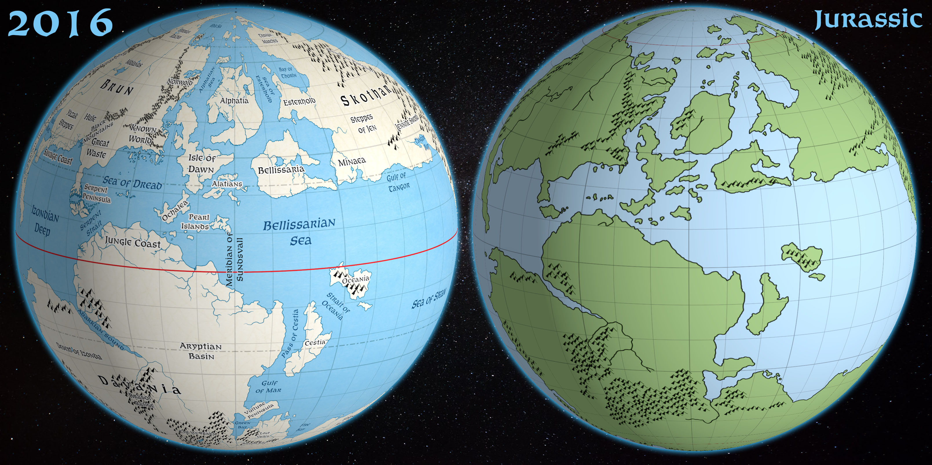
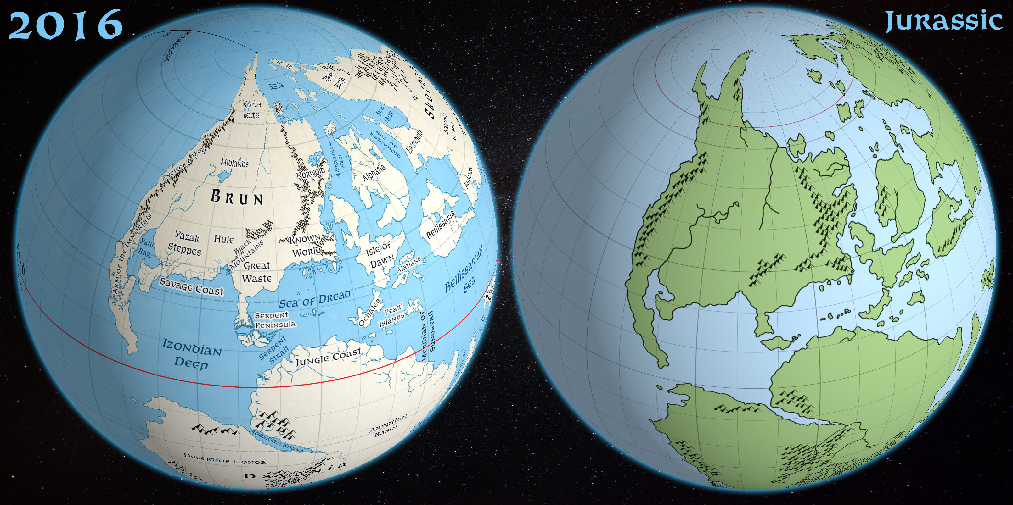
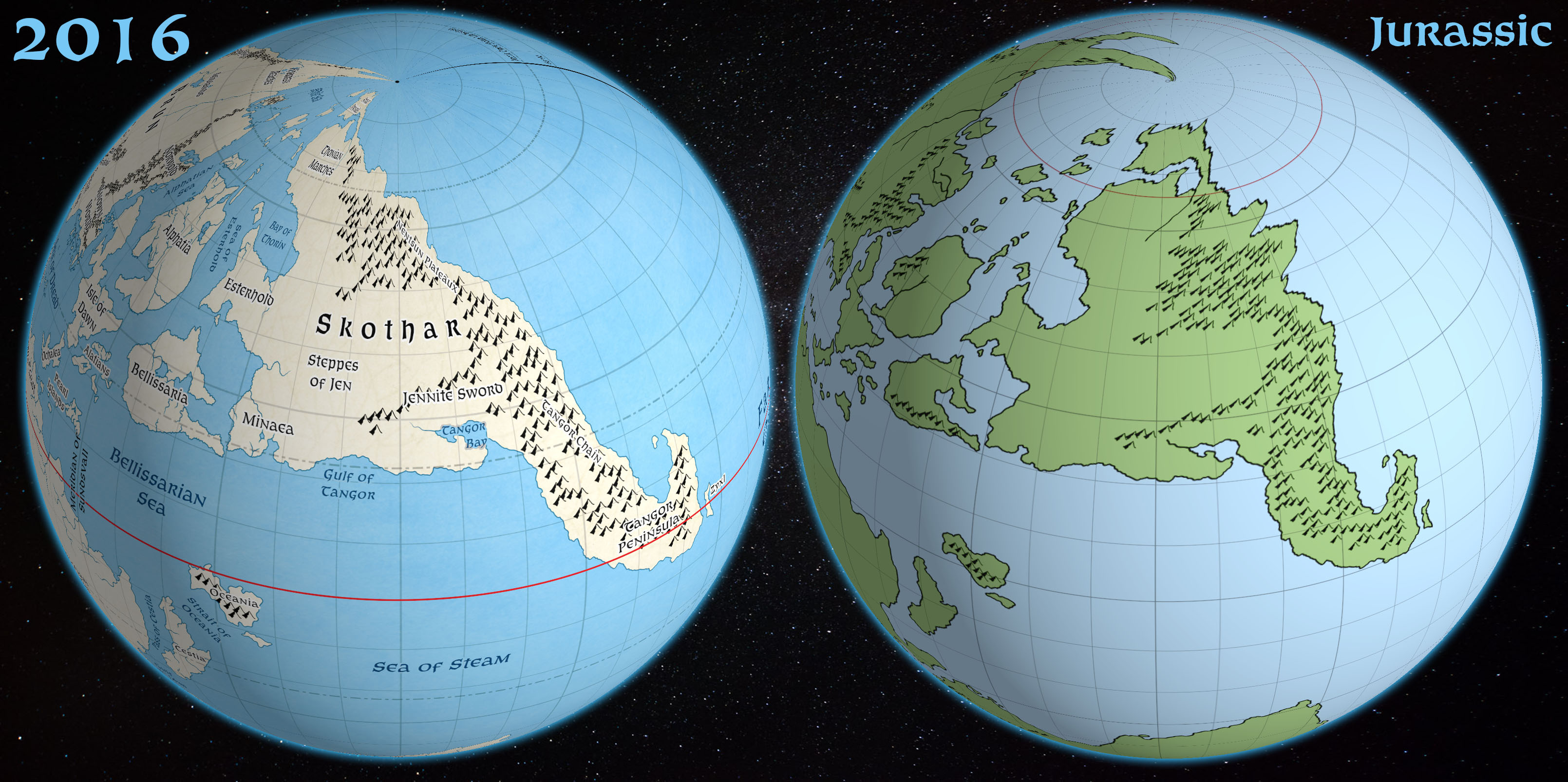
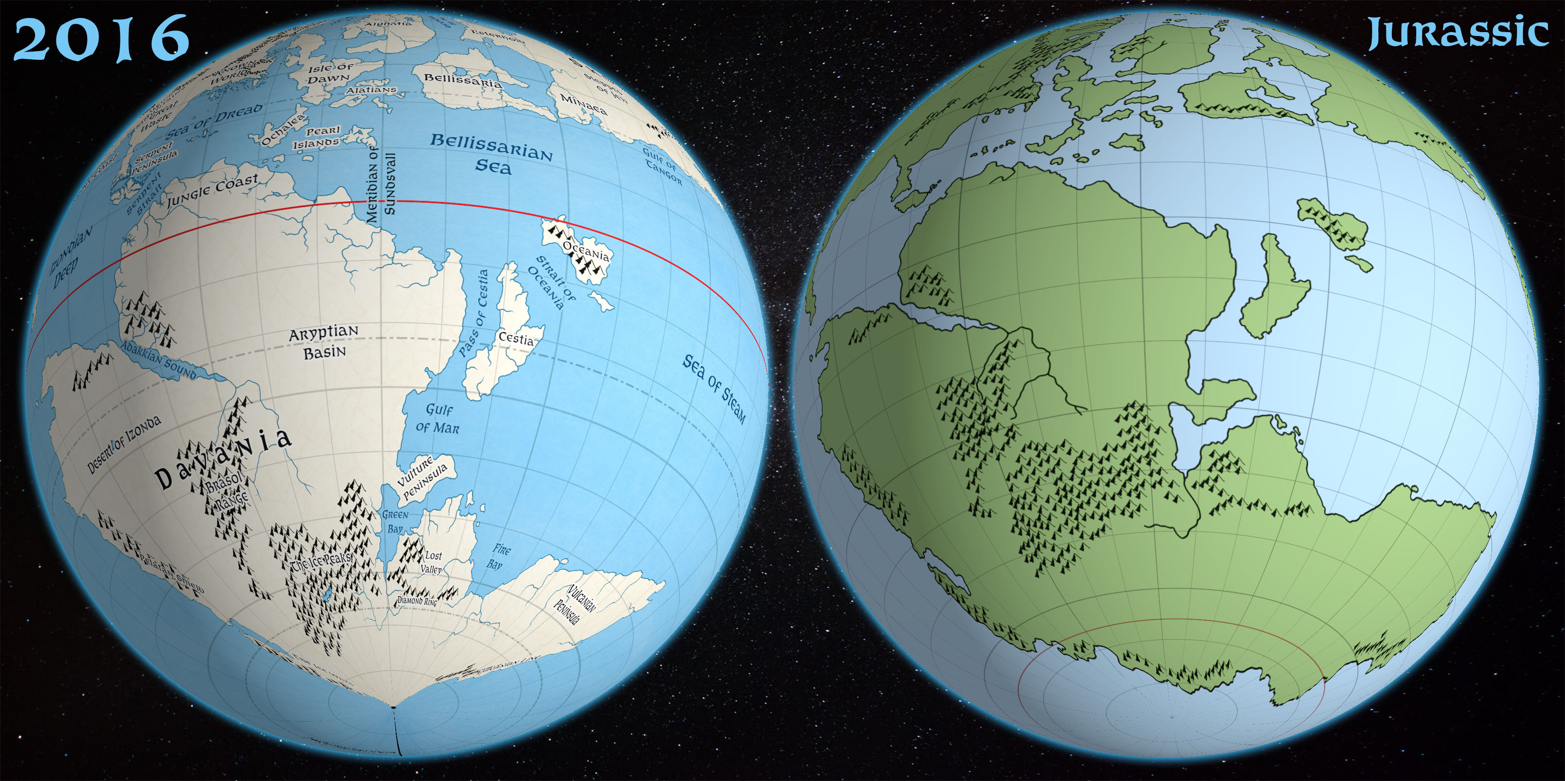
To sum up: while the shape of Skothar may take some getting used to, Brun undeniably looks far better on Jurassic Mystara’s globe. What’s more, Davania is the huge continent we’ve always expected it to be. Overall, the continents are as large as you would expect them to be given their real-world analogues: Brun is composed of North and Central America; Skothar is made up of parts of Europe and Asia, with the rest of Europe in between, the Isle of Dawn being Britain and Ireland and Alphatia being Scandinavia; and Davania is South America, Africa, Antarctica, India, and Australia.
On the other hand, my 2016 model’s continents universally suffer from pinched poles, due to the erroneous use of Equirectangular projection. This was something that I noted back in 2016 that still needed to be fixed, but it goes further than that, affecting far lower latitudes than I had at first thought. Brun’s northern parts look squashed, while Davania’s Vulcanian Peninsula is rather small. Skothar’s Nentsun Peninsula is squashed into oblivion.
The conclusion?
I was wrong.
The Master Set world map is without a doubt a Mollweide projection map. It is not an Equirectangular projection.
It’s easy to see this in hindsight now. I’m sure I should have realised earlier, because I’m quite familiar with the concept that the Equirectangular projection does not show the “true” shapes as you will see them on a globe. I’ve even written a tutorial on how to avoid this very issue. But I guess I was too close to the project to realise this myself.
Revisiting the 2016 Model
The inevitable consequence of these revelations is that I must revisit the results of my Lining Up project and revise my model to reflect the proper shapes of the continents.
While this may at first seem like a setback, on the contrary I view it as a massive step forward. After all, I’ve been searching for the proper projection for Mystara for years; my first assumption was wrong, but that does nothing to take away from my excitement at finally knowing the correct projection.
Make no mistake, this is a wonderful thing. It means that in fact not only the world map but also all of the hex maps have been mapped to a proper projection all along.
However, there are problems. Hey, it wouldn’t be Mystara if we didn’t have problems to work through, would it?
The main issues are:
- Latitude — Jurassic Mystara places the Known World coastline further south than any of our previous models. Thyatis is at about 25°N. Moreover, the northern parts of Brun are also further south, with Farend coming at 51ºN. This compared to official figures of 30ºN and 60ºN respectively, which we were able to achieve in my 2016 model.
- Size — scaling by the hex maps, Jurassic Mystara is over 36,000 miles in circumference. If this problem sounds familiar, that’s because we already dealt with it two years ago in my last project.
- Projection — now that we know that the official maps are mapped to the Mollweide projection, it’s possible to georegister all of the official hex maps. Whereas before we had thought they ignored projections entirely, and therefore defaulted to Equirectangular, in fact that was not the case. The trouble now, however, is that moving the continents around on the globe — as we may want to do to fix the latitude issues — may result in breaking this connection. In other words, if we change the configuration of the world to fix latitudes, it may require all the hex maps to be redone.
In this new series of articles, I’m going to work through these problems, with the ultimate goal of creating a hybrid 2018 model of Mystara that incorporates Jurassic Mystara’s shapes into my 2016 model.
One last thing: if you’re worried that this will delay the 72 mile per hex continental maps, you can relax, as I still intend to finish all three of these maps. Eventually I will likely need to create updated versions, but I feel it’s definitely worth finishing these three maps now.
Do you have any comments or suggestions? Please feel free to chip in below!
One last word…
If you enjoy my maps and would like to see more of them, you may be interested to check out my Patreon.
Thank you for all of your support!


17 February 2018 @ 9:27 pm
Wow! This is fabulous, Thorf! =)
17 February 2018 @ 9:51 pm
What does it mean for the Far End Ocean (I think that’s its name)? It is now less vast?
17 February 2018 @ 9:57 pm
Pretty much the same. But we now know conclusively that it was inherent in the design of the world from the start.
18 February 2018 @ 1:59 am
Looking good. FWIW, I’d be inclined to treat the latitudes as approximates and go with the new numbers. It’s also possible that they were simply wrong in their original publication.
Lining Up Mystara Revisited III – Thorfinn Tait Cartography
21 February 2018 @ 12:03 am
[…] I outlined three problems at the end of the first article: […]
Mystara Climate Maps II – Thorfinn Tait Cartography
6 March 2018 @ 12:32 am
[…] Lining Up Mystara Revisited project is proceeding apace. I’m still working on the next post, but in the meantime I want […]