In this thread, you will find a lot of maps, which have been posted daily since February 2005, excluding a few break periods. To make everything more accessible, Shughuy has helped me to make an index of the maps that have been posted so far. I will try to keep this index more or less up to date, but you can always check the latest posts for the latest maps.
Note that maps are divided into two categories: replica maps and updated maps. Replicas are accurate recreations of existing maps, usually including errors and such. Updated maps are my own interpretation of all the available sources, fixing errors and consistency to create a new super-accurate set of Mystaran maps.
 Thorf's Secret Project: Stage One
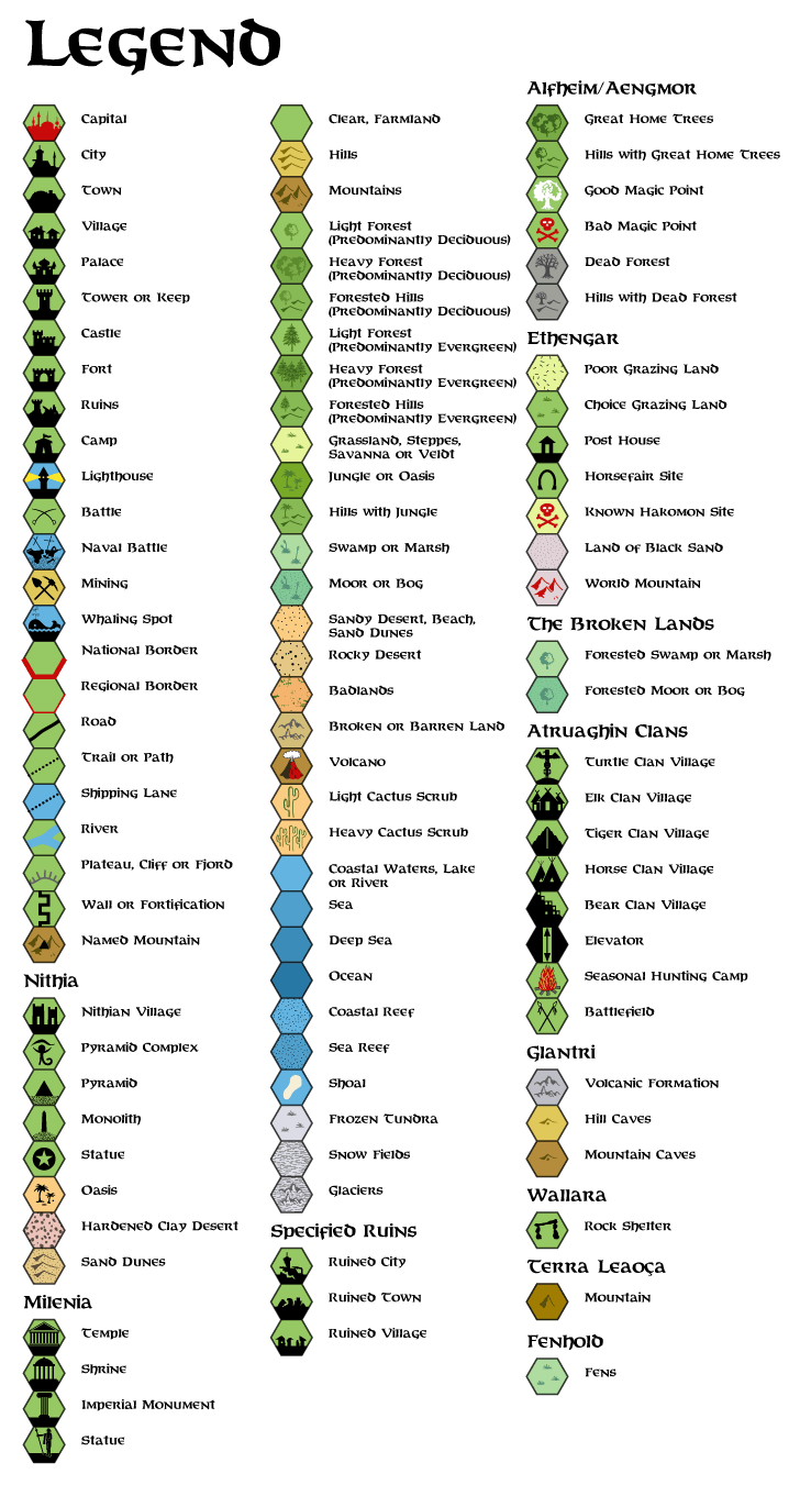
Legend
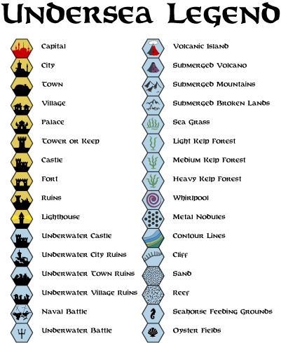
Undersea Legend
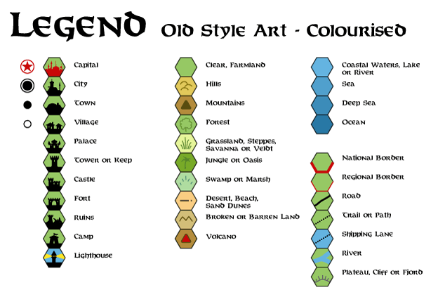
Colourised Old Style Art Legend
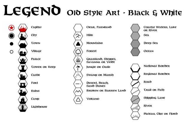
Black & White Old Style Art Legend
 Updated Maps: 2 mi per hex (1)
- City of the Stars, 1000 AC New! 30th April 2006
Updated Maps: 8 mi per hex (27)- Aengmor, 1010 AC
- Alfheim, 1000 AC
- Atruaghin Clans, 1000 AC
- Upper Broken Lands, 1000 AC
- Lower Broken Lands, 1000 AC
- Darokin, 1000 AC
- Ethengar, 1000 AC
- Five Shires, 1000 AC
- Glantri, 1000 AC
- Gulf of Hule, 1000 AC Updated 30th April 2006
- Herath, Shazak, Ator and Cay, 1000 AC
- Ierendi, 1000 AC
- Isle of Dawn, Western Region, 1000 AC
- Karameikos, 1000 AC;
also a mostly forested hills version - Minrothad, 1000 AC
- Nithia, 1000 AC
- Northern Reaches, 1000 AC
- Orc's Head Peninsula, 1000 AC
- Rockhome, 1000 AC
- Savage Baronies, 1000 AC Updated 30th April 2006
- Savage Coast, Central Region Major update 16th March 2006
- Shadow Elf Territories Updated 30th April 2006
- Sind, 1000 AC (Under development)
- Southern Hule and the City States, 1000 AC
- Thyatis, 1000 AC
- Wendar, 1000 AC (Under development)
- Ylaruam, 1000 AC
Updated Maps: 24 mi per hex (5)- Alatian Islands, Pearl Islands and Ochalea, 1000 AC Updated 30th April 2006
- Alphatia, 1000 AC Updated 30th April 2006;
also deciduous forest version - Arm of the Immortals and Orc's Head Peninsula, 1000 AC
- Great Waste, 1000 AC
- Serpent Peninsula, 1000 AC
Updated Maps: 40 mi per hex (2)Replica Maps: 2 mi per hex (1)- City of the Stars Cavern from GAZ13 New! 30th April 2006
Replica Maps: 6 mi per hex (4)- Isle of Dread from X1 (1981)
- Isle of Dread from X1 (1983)
- Karameikos from the Expert Set (1981)
- Karameikos from the Expert Set (1983)
Replica Maps: 8 mi per hex (25)- Karameikos from GAZ1 Updated 6th May 2006
- Lower Broken Lands from GAZ10 Updated 6th May 2006
- Shadow Elf Territories from GAZ13 Updated 30th April 2006
- Atruaghin Clans from GAZ14
- Slagovich and the City States from Dragon 171
- Southern Hule from Dragon 172
- The Savage Baronies from Dragon 174 Updated 30th April 2006
- The Savage Baronies from Dragon 175
- The Savage Baronies from Dragon 176
- Robrenn from Dragon 177
- Eusdria from Dragon 178
- Renardy from Dragon 179
- Bellayne from Dragon 180
- Eastern Herath from Dragon 183
- Shazak, Ator and Cay from Dragon 185
- Wallara from Dragon 186
- Jibaru from Dragon 188
- Nimmur from Dragon 192
- Black Orchid Tribe Lands from Dragon 196
- The Sea of Dread Submerged Lands from PC3
- Western Isle of Dawn from TM2
- Azcan Empire, 1000 AC from HWR1
- Southern Kingdom, Kingdom of Nithia from HWR2
- Delta Kingdom, Kingdom of Nithia from HWR2
- Milenian Empire, 1000 AC from HWR3
- Northwestern Shahjapur, 1000 AC from HWA3
Replica Maps: 12 mi per hex (1)- Old Averoigne from X2 New! 5th March 2006
Replica Maps: 24 mi per hex (23)- Known World from X1 (1981) Updated 30th April 2006
- Known World from X1 (1983) Updated 30th April 2006
- Known World from the Expert Set (1983) Updated 30th April 2006
- The Vestland Area from X3 Updated 30th April 2006
- Great Waste from X4 Updated 30th April 2006
- Hule from X5
- The Serpent Peninsula from X6
- The Savage Coast from X9
- Wendar and Denagoth from X11
- Norwold from CM1 and M2
- The Alatian Islands from Dawn of the Emperors
- Alphatia from Dawn of the Emperors
- Isle of Dawn from Dawn of the Emperors
- Ochalea and Pearl Islands from Dawn of the Emperors
- Sind from Dragon 169
- Orc's Head Peninsula from Dragon 196
- Arm of the Immortals from Dragon 200
- Known World from the Rules Cyclopedia
- Known World, 1004 AC from Wrath of the Immortals (original palette version)
- Known World, 1004 AC from Wrath of the Immortals
- Known World, 1010 AC from Wrath of the Immortals
- Great Waste from Champions of Mystara
- Serpent Peninsula from Champions of Mystara
Replica Maps: 40 mi per hex (3)- Northern Iciria from the Hollow World Set
- Southern Iciria from the Hollow World Set
- Alphatian Neatharum from Wrath of the Immortals
Replica Maps: 48 mi per hex (1)- The Known World from Wrath of the Immortals New! 4th March 2006
Replica Maps: non-hex (2)Other Maps (2)- Azcan Empire 40 mi per hex map with 8 mi per hex map overlaid
- Milenian Empire 40 mi per hex map with 8 mi per hex map overlaid
(I have moved the original first post of this thread into the second post, down the page a bit. Sorry for the confusion this may cause!)
Look forward to seeing more...
Gary
Last week I revealed to you that my secret project involved maps. Now you will start to see some of these maps. The maps themselves are not my secret project per se, but they do constitute a major part of it. ;)
cool, and this isn't even the real project yet
GP

I've kept you waiting for almost a week, but finally the time has come. Starting today, I will be releasing one map (sometimes more!) every day in this thread.
Last week I revealed to you that my secret project involved maps. Now you will start to see some of these maps. The maps themselves are not my secret project per se, but they do constitute a major part of it. ;)
First up, here is the full Legend for using with all of my maps. I decided that it makes more sense to keep it as a separate image, to save bandwidth. Besides, you all know what the hexes mean anyway. :P
Now that that's out of the way, here is the first map. I've been wondering for a while which I want to post first, and I decided to go with tradition, and give you one from the very start.
Notes
This map is based on the original Expert Set map, with additions from X1 and X3. As such, it's a largely undeveloped form of the world, before it came to be as we know it today. It's an almost exact copy of the original map, using the hex art I created. The font used (Baldur) is different, and label positions have been changed slightly. Otherwise, it is in all respects faithful to the original.
The original map was black and white. Where labels were placed, the underlying terrain symbols were often not visible. Blank hexes on this map
represent white or obscured hexes on the original map, but are coloured to match this cartographer's best guess at the intended terrain type. In many
cases, subsequently released maps clarified the terrain type, but in the interests of accurate duplication, these have not been taken into account here.
The hex art used here differs from the original symbols, based as it is on the later Gazetteer series maps. Since both symbol sets are fully compatible,
the difference is purely visual. Many of the later terrain types had not yet been devised, notably heavy forest, forested hills and rocky desert.

I'm home for my lunch break and have a moment spare, so here is today's map.

As an added little bonus, for comparison I also have another version without the forested hills marked on. I don't want to clog this thread up with too many maps, though, so click here for the other version.
On that subject, should I change the old maps to links as we move on? Otherwise the thread is going to get really slow pretty quickly. Maybe I should leave a map in the thread for a few days, then change it to a link.
Edit: I'd like to know what you all think about the forested hexes. The current map here includes the official take on things, as seen in Karameikos: Kingdom of Adventure, but the text does suggest that pretty much all the hills are forested.
Another question: do you think I should incorporate a colour gradation for forest/heavy forest/forested hills? I often think it looks kinda messy (cf. K: KoA, for example), but it does let you see the terrain types better at a glance.


Edit: I'd like to know what you all think about the forested hexes. The current map here includes the official take on things, as seen in Karameikos: Kingdom of Adventure, but the text does suggest that pretty much all the hills are forested.
I like the forested hills as they are in this map. I must admit it's been so long since I read the geography bit of gaz 1 that I can't remember how much should be forested hills instead of just hills.
Another question: do you think I should incorporate a colour gradation for forest/heavy forest/forested hills? I often think it looks kinda messy (cf. K: KoA, for example), but it does let you see the terrain types better at a glance.
I prefer that the heavy forest is a darker shade of green. It "makes sense" and provides a better glance of the terrain, I think.
Looking forward to more of these fantastic maps!
:-) Jesper

Excellent. I'll definitely be making these available to my players.
My compliments!
Just one question: are you using Hexmapper (coz I seem to recognize it)? If so, how long does it take to draw a map like that? I remember that I used it to draw some pretty detailed maps of my homebrew world and it took me hours literally, although it was too damn fun to use it :P
Good work !
I am particularly interested in the maps of the Isle of Dawn, Norwold and the Arm of the Immortals, so I'm looking forward to them ;)
And it is a lot of fun to do, though sometimes it gets to be a bit of a chore too. In any case the results are well worthwhile.

Good work !
I am particularly interested in the maps of the Isle of Dawn, Norwold and the Arm of the Immortals, so I'm looking forward to them ;)
Those will be coming, but don't hold your breath. :P Right now I'm trying to work through the maps chronologically, to get a feeling for how things developed and to find errors as and when they appeared. And of course the official maps will likely come before I start work on any conversions.
I just updated all the files because I noticed that the scale marker hadn't rendered properly. Also, I have implemented a provisional scaled colour scheme for forests. I deliberately made it very subtle, though I'm not absolutely set on those shades as yet. Please check it out and tell me what you think!

Edit: Map has been updated with what I believe to be a more aesthetic form of shading on the forested hill hexes. Comments please!
1. The World Mountain of Ethengar should be present, IMO, since it's big enough to get its own hex in the middle of the steppes. I also think you should show the Ethengar lakes.
2. Ierendi should sport some volcanoes, as well as Glantri.
3. X2 is marked there near the Broken Lands border but, well... it shouldn't be there. The premise is that wherever they are the PCs are spirited away by the mists and end up in the "prison dimension" of Castle Amber. So you cannot really place X2 on Mystara.
4. X4 and X5 are located in the wrong position and direction. They should point south-westwards instead of north-westwards from the Adri Varma Plateau. Anyway I wouldn't list them at all, or if you do, You must also add X10 (same direction) and X11 (pointing northwards from Glantri's northern border)..
5. X7 should be placed IIRC in the waters between Thyatis and Minrothad, a bit southwards
6. X8 should be placed in one of the little isles far off the coasts of Thyatis
7. X12 should be placed in Karameikos (IIRC it's Skarda's Mirror set in... Verge?)
8. X13 should be placed in Vestland
9. CM8 should be placed in Glantri
10. CM9 should be placed in Darokin, very close to the southern Alfheim border
That's all for now ;)

But I think you kinda missed the point of this map in the first place - it's supposed to have all the errors, because it's Mystara as we saw it for the very first time way back in 1983. :P As I work through the maps in roughly the order they were made, I will update this map, until eventually it becomes the Mystara we know today.
I probably should have explained better, but the reason for doing it this way is that it's worth having the original maps to refer back to when the newer ones (Wrath of the Immortals, for example) screw something up.
 ;)
;) I can see how it might be confusing, since the next one I released was an entirely up-to-date map of Karameikos...
You've actually given me a good excuse to post another map, that should help you understand what I'm doing here. :D

It's an exact replica of the original Expert Set map, using my hexes. Add X1's map and the tiny map in X3, and you have my current Known World and Sea of Dread map, the first one in this thread.
Confused yet? :evillaugh
However, I can't find your Karameikos map with forested hills - at the time of posting both versions on your Mystara page are identical...
It is interesting that you are planning to present many different alternative versions of the maps, based on various originals.
If you are interested, I have some ideas for incorporating non-canon elements in some of them in the future aswell, though I understand that you will probably want to go through the canon versions first.
Another thing Id like to see is maps using a different focus. For instance a map showing the Known World and Sindh, The Known World + Wendar/Heldann/Denagoth or The Known World + The Isle of Dawn. I have been working on such maps myself and I find that if I move away from the traditional perspective, I find very interesting results.
As The Known World developed, it makes more sense if there is just as much interraction between mainland Thyatis and the Isle of Dawn as there is between Thyatis and the rest of the Known World for instance.
Håvard
I do indeed plan on dipping into non-canon stuff, but you are correct that I am planning on going through the official maps first. It seemed appropriate to start at the beginning, especially after realising that starting at the end brings up lots more inconsistencies. But that discussion is for the other thread... :P
Anyway, rest assured that all those areas are on my list, and I will get to them before too long, I hope. And doubtless discover new fun along the way. :D
On another note, I have decided to revise the forest hex shading once again. This time I'm going to shade both heavy forests and forested hills the same, ever so slightly darker colour. I just couldn't find a suitable colour for the forested hex tile, and this solution seems to work. Once again, if there are any more suggestions or comments on this, I'd love to hear them.
The image in this thread should be updated shortly...
Today I got some interesting offers for help from a number of people. I hadn't really considered that people would want to help, but now I'm considering putting together a team to work on my project. If anyone's interested, please e-mail me. I do realise that no one actually knows exactly what the project is yet, other than mapping.

I've managed to resist posting another map tonight, so the next map should be posted tomorrow at lunchtime, about twelve hours from now. See you then! :D

Somebody mentioned Hexmapper - I tried it, but I couldn't do much with it - it seemed like it had a fixed-size hex grid that I couldn't expand, and I couldn't see any way to draw coastlines or rivers. Did I miss something?
Instead, I just started writing my own. What I want is a mapping program that I can use to scroll and zoom maps, so that I can start with a 72-scale map of most of known Mystara, click on the Known World to zoom into it, and then click on a country to zoom in to that. I'm also thinking of writing a scanner to look at picture files and build maps for my tool out of them. (Hexagons can't be too hard to recognize, can they?) But I just started thinking about this last week (before I discovered this board) and I'm notorious for getting excited about a project and dropping it a few weeks later, so no promises.
There are links to HexMapper and Quickview on my webpage and a map of a region of my new world, Ursia, called the Dark Coast.
http://home.psknet.com/allenr/Dark_Coast.html
http://home.psknet.com/allenr/Ursia/Dark_Coast_24mile.jpg
--Ray.

I already spotted the missing battlefield symbol in the bottom left, and it will be fixed next time I upload files, probably tomorrow. Otherwise, this should be a completely up to date map of Ylaruam for AC 1000.
It seems likely that I'm going to continue in Gazetteer order, more or less. But I might pull a few surprises later on, so don't count on it. :P
First, here's today's map.
Today's map!!!! It's late, I'm going to bed! What do you live on the other side of the world or something! :D
Alright! The PCs IMC are heading to Ylaruam this Saturday from Vestland; perfect timing. I'm actually pretty excited because I've never had characters go there before!
I'm glad I could be of service.
Hope you have a fun game.Today's map!!!! It's late, I'm going to bed! What do you live on the other side of the world or something! :D
Hehe, nah just the opposite side of the hemisphere really. :P I did consider when I started this thread that my days probably won't correspond with those of anyone else reading this.

On a totally unrelated note, I got sidetracked in my posting here just now, because I suddenly decided to revise all my hexes. After noticing that the Broken Lands tiles on the Ylaruam map weren't up to date with my most recent version, instead of simply updating them I decided it was finally time to redo the tile. That prompted me to revise a whole set of tiles to make them look slightly finer, and I ended up totally redrawing my volcano too, which I had been putting off for ages.
So, soon I will be uploading the corrected Ylaruam file as well as updating the Legend file at the top of the page in this thread! Keep your eyes peeled (those of you who aren't asleep, that is :P).
Great maps! I think the forest shadings are reversed, though - heavy forest should be the darkest green, and forested hills in the middle.
Interesting. I did notice that they were like that in Karameikos: Kingdom of Adventure, but I've never liked that map, to be honest. I think the shading differences there are too stark, and end up making the map look kinda ugly.
But anyway, for now I have gone with a single very subtle shade which I have given to both heavy forests and forested hills. It seems to work okay so far. I've also considered changing the colour of the forested hills tree to match the hills, though I would like to keep it "tree-coloured" and reserve the darker shade for Alfheim's Great Home Trees.
Somebody mentioned Hexmapper - I tried it, but I couldn't do much with it - it seemed like it had a fixed-size hex grid that I couldn't expand, and I couldn't see any way to draw coastlines or rivers. Did I miss something?
I can't really remember which program I tried, but in any case I think in the end Illustrator is the most powerful tool. That doesn't necessarily make it the best, though, because more specialised programs can provide a certain amount of automation for mapping - if they're done right.
Instead, I just started writing my own. What I want is a mapping program that I can use to scroll and zoom maps, so that I can start with a 72-scale map of most of known Mystara, click on the Known World to zoom into it, and then click on a country to zoom in to that. I'm also thinking of writing a scanner to look at picture files and build maps for my tool out of them. (Hexagons can't be too hard to recognize, can they?) But I just started thinking about this last week (before I discovered this board) and I'm notorious for getting excited about a project and dropping it a few weeks later, so no promises.
That sounds great! My project encompasses maps for all those areas, in all three scales, although it's still in the early stages. If you can use the Illustrator files for my maps to power your program, that would end up being a very nice program, I think.
The other mapping tools you mention also sound very interesting. Please keep us informed on your progress! And if I can be of any assistance, I will be happy to help in any way I can.
There are links to HexMapper and Quickview on my webpage and a map of a region of my new world, Ursia, called the Dark Coast.
http://home.psknet.com/allenr/Dark_Coast.html
http://home.psknet.com/allenr/Ursia/Dark_Coast_24mile.jpg
Very nice maps, Ray! Did you do the hex art yourself? They look extremely similar to the official hexes. It's great to see such high quality maps.
These mountains tend to be thickly covered with forest vegetation, gradually thinning to bare rock toward the peaks. The average height of mountains in this range is about 4,000 feet, though many are much larger.
South of this mountain range, you have [HIGHLIGHT]miles and miles of mountain foothills - also thickly covered with forest[/HIGHLIGHT].
...and...
Karameikos is one of the most thickly-wooded nations of the world. In the northern parts of the Grand Duchy, [HIGHLIGHT]pine forests cover the mountain slopes and the hillsides[/HIGHLIGHT]. The further south you get, the more hardwoods - oak especially - you see; in the southernmost parts of the Dymrak Forest of eastern Karameikos, all you see are ancient oaks towering into the sky.
[It continues, describing the "three great tracts of forest" in Karameikos. The description of the forests doesn't mention anything about hills, but doesn't rule out forested hills as parts of those forests either.]
...and...
Callarii Lands
The Callarii elves live in the central forests east and west of Kelvin and in [HIGHLIGHT]the forested foothills south of the gnomish community [Highforge][/HIGHLIGHT].
It seems, then, that the situation is a lot more complex than we first thought. According to this, there should be evergreen forested hill hexes at the foot of the mountains, changing into deciduous forested hexes as the altitude drops. And almost all the hills in Karameikos are apparently forested.
An interesting side-point from p.35 is that apparently the Achelos Woods and the Riverfork Woods are one and the same - Achelos is presumably the traditional Traladaran name, Riverfork the Thyatian name. It says, "Farthest west, near the border, is a thick forest area variously called the Riverfork Woods and the Achelos Woods." Karameikos: Kingdom of Adventure confirms this, and the map in that book also agrees.
Talking of which, an examination of Karameikos: Kingdom of Adventure proves that it states all the things I listed above, and in almost exactly the same words. ;)
So to get back on topic. here's my current conclusion:
- The first hex or two next to the mountains should be evergreen forested hills.
- All other hexes except a token few should be deciduous forested hills.
Is anyone interested in seeing a map made up to illustrate the point?
Is anyone interested in seeing a map made up to illustrate the point?
Yes please :bounce:
Is anyone interested in seeing a map made up to illustrate the point?
Oh yeah!
:-) Jesper
I like the map of Ylaruam alot! Perhaps at a later time, you could name a similar one of Ancient Nithia, by just replacing the hexes and adding the river Nithia? James Mishler did a map of Nithia already that you could use as a basis. I guess this would be another thing for later, eh? ;)
Håvard

To be honest, faithful as this is to the Gazetteer's text, I think it's going a bit too far.
As for Nithia... While I was doing the Rockhome map a few weeks ago, I came across the source for the River Nithia again, and I added old Nithia to my "wish list" for maps to make.

It would be a fun one to do... I'd probably use the Hollow World Nithian Empire as a major source/inspiration. It would be fun putting pyramids all over Ylaruam! :D
But as you say, it'll be a while before I get to it.
Well, that's all for me from today. Seemed like a long day. See you again tomorrow for another map.
PS - I'm starting to think that forested hexes would look better with just the normal "plains" colour for their background. Do you think it's enough to just have the heavy forests shaded? I'm still open to opinions and suggestions.
Very nice maps, Ray! Did you do the hex art yourself? They look extremely similar to the official hexes. It's great to see such high quality maps.
The hexs came with HexMapper but I used Quickview to do the coastlines and the borders.
BTW, do you have your hexs available for download? If they are in .bmp format, they could probably be used with HexMapper too.
--Ray.
...with forested hills throughout!
Wow... that's a lot of trees...
PS - I'm starting to think that forested hexes would look better with just the normal "plains" colour for their background. Do you think it's enough to just have the heavy forests shaded? I'm still open to opinions and suggestions.
I am confused
 Seems to me the forested hexes have "plains" colour as their background? And heavy forest hexes are a darker shade?
:-) Jesper
I wonder what it would look like if the "hills" in the forested hills hex were a brown colour; kind of a combination of the forested hex and hills hex. I really can't picture it on a map in my mind, but maybe you could test it to see if it works or not (I have a feeling it wouldn't, but you never know till you see it).As for Nithia...
Oh ya, I'd like to see that!...with forested hills throughout! To be honest, faithful as this is to the Gazetteer's text, I think it's going a bit too far.
Visually perhaps, but I've always seen this to be the way in which Karameikos was described. On the map it appears to be one huge, unending forest, but it actually only represents that these hexes are dominated by woods. There are still many open areas and grassy fields. Perhaps you could place a few "open" hexes here and there to show areas where there is more open space than forest (i.e. areas where the woods are in small isolated patches).
Bottom line though is I like your new vision of the "dark-forested Karameikos wherein the lycanthrope and undead find their shelter".
The hex grid is on top of everything else. That is fine because most things such as trees or mountains do not cross into another hex. But roads and trails do. And I must say that looking at the maps from 40 cm away I think it looks like lots of little "holes" or gaps in the roads and trails.
If I had my way, roads and trails should go on top of the grey hex grid. not the other way around.
Other than that: like I said - beautiful! :D
:-) Jesper
BTW, do you have your hexs available for download? If they are in .bmp format, they could probably be used with HexMapper too.
Yep, they're in the first post of this thread, in PNG format. You can easily change it to BMP format using any image editing program.
I have to go to work in about two minutes, so I'll reply to the rest later. For now, here's a map or two to tide you over! :D

This is my revised Glantri map, using evergreen hexes for the appropriate forests, as described in the Gazetteer.
For the traditionalists among you, I also have a map using all deciduous forest hexes, which I can provide at your request.
PS - Spellweaver, look at the forested dominions to see what I mean about the shading. I could change the colour underneath the settlements to match the forested hexes, but I'd rather just normalise the forested hills again. Also, forested hills and heavy forests are indeed the same shade right now. I did say it was very subtle! :P
PPS - (Gonna be late for work!! ARGH!!) Also I agree with you Jesper about the roads and trails. I had noticed it too while making the maps, but I never got round to fixing it. It's actually not just a trivial fix - it might require me to add in another layer, or at least do a layer reshuffle. Anyway I'll start working on it, and post new versions of all the maps when I get it done.
If the Mystara setting were ever redone I would like to see the maps redone as well.
I hope you are going to redo ALL the Gazetter maps, as the land of Mystara is not just The Grand Duchy of Karameikos, but all the surrounding lands as well.
I hope you keep up the good work that you are doing, it is VERY much appreciated, and many of us will be looking forward to it. :D
Thanks also for the new version of Karameikos, that fits a lot better with my understanding from the text, and I think it also makes better sense geographically - there would need to be a reason for the trees to stop so far form the mountains and there doesn't seem to be one - this way the forest goes all the way to the natural boundary
I think what you're doing thorf is a great idea, and it is a long time overdue.
If the Mystara setting were ever redone I would like to see the maps redone as well.
Yep, and that's why I'm redoing them. ;) With this techonology at our fingertips, and the time to devote to the project, we can actually make maps that surpass the quality of the originals - and the accuracy of the originals too.
The only disadvantage really with these maps is that it's not so easy to print them out. But in my case, I can probably get a pretty nice big printout next time I visit my parents. If I can get the colour settings right, it really will mean that my maps are equal or better than the official ones in all ways.
I hope you are going to redo ALL the Gazetter maps, as the land of Mystara is not just The Grand Duchy of Karameikos, but all the surrounding lands as well.
Yes I agree wholeheartedly there. In fact, I already have almost all the Gazetteer maps done. But I'm only posting one a day, because I'm going to run out of things to post pretty soon. :P Anyway it's nice to hear feedback on each map as it appears, and hopefully correct any mistakes that are found.
I hope you keep up the good work that you are doing, it is VERY much appreciated, and many of us will be looking forward to it. :D
Thanks very much!
On a different note: Katana One has been helping me with some handy Illustrator advice and tips, and hopefully I'll be able to make the jump from 8.0 up to Illustrator CS pretty soon - hopefully by next week. Doing so opens up a whole lot of new possibilities, including one feature that was on my wish list from the start - a transparent hex grid.
I'll keep you informed, and when I do upgrade, I'll do a pass of all the currently released maps using the new features, and upload them here. It will likely take some time, though.
One last thing before I go to bed: I've had some life changing decisions to make this week, and it's going to come to a head at the weekend, so don't be too surprised if my updates stop for a few days. I probably won't be able to resist coming and posting a map anyway, but apologies in advance if I don't manage.
And good luck with all the life-changing decisions!
But I have a lot to show for it. With the help of Katana One, I have finally been able to update my files to the latest version of Illustrator. If you don't think that sounds exciting, go and check out the Karameikos map in page one of this thread - the one nearest the top of the page. Alternatively you can click here. I just spent over an hour converting the map just so I could post an example of what the maps will be like from now on, thanks to Katana One's help.
I just wish I had time to help out even more!
Anyway, now I'm off to teach 18 year olds at a local high school. You might say I'm an odd job man here. But before I go, here's today's map!

Of course I didn't have time to update it (or any others) yet, so it's still in the old format. I'll give you all a heads up whenever I upload an updated map so you can keep with the most current versions. This map and others with lots of sea probably benefit the most from being upgraded, because the solid hex grid looks really ugly on the ocean.
Today I'm giving you Alfheim...

...and its "evil twin", Aengmor. ;)

For now, the Aengmor map is really nothing but an Aflheim map with forest hexes switched for dead forest hexes. In the future I hope to make a few more additions to it, so if you have any suggestions, I'd love to hear from you. :D
For now, the Aengmor map is really nothing but an Aflheim map with forest hexes switched for dead forest hexes. In the future I hope to make a few more additions to it, so if you have any suggestions, I'd love to hear from you. :D
At the time, I had some ideas regarding an "evil" wood-imp kingdom around the former Dreamlands. This is non-canon, of course - so I don't know if you'd wish to use it at this point. Anyways, the link is:
http://boards1.wizards.com/showthread.php?t=198356
EDIT: Oh, and you'd might wish to take a look at PC1 regarding the Alfheim map. It has some unique features for the area - such as Hsiao complexes etc.
What I'll probably do is just remake the map from PC1 eventually.
In any case, continuing with the maps, today is Rockhome.

I'm not sure what to do about Rockhome's trees. According to the Gazetteer, most of them should be evergreen hexes, but the trees on Darokin border are a little bit questionable. Eventually I think I'll probably end up making those trees in Darokin evergreens as well.
Edit: I just changed the map to the updated version, with evergreen forests. If you want to see the updated version with deciduous forests left intact, please ask me.
One thing on the Rockhome map - you have preserved the split river (labelled Klintest River) leading both into Lake Klintest and into the Northern Reaches. Whilst I am happy with this, the branch of the river flowing East to the border should not be the Klintest River (I can't remember the real name) - it is not flowing into the lake but into the sea. The little arm pointing South is not a tributary - it is the source of both rivers, so the river to the border has to be a different waterway.
As for your tree problem - in temperate lands there is usually an altitude line below which the forests are deciduous and above which conifer. This would enable all the Rockhome woods to be evergreen and the Darokin woods deciduous - Rockhome merely claim the mountains down to the treeline change...
One more thing regarding Aengmor: Did all the lakes and rivers of Alfheim survive the change?
That's a good question. I don't know the answer - it depends on whether you think that the elven magic which created Alfheim's nightly rains is still in effect or not. I do seem to remember GAZ5 mentioning something about the elves performing some kind of "upkeep" to keep the magic working...
On the other hand, Aengmor would look pretty boring without them. :P
By the way, I have now updated and posted the following maps: Karameikos, Ylaruam, Alfheim, Aengmor, Rockhome. The rest should follow before too long. Unfortunately all this updating has brought my progress on making new maps to a halt. This week looks like it'll be pretty busy, but then from next week I'm going to have a lot more free time for a month or two, so hopefully I can get back on track.
On the other hand, Aengmor would look pretty boring without them. :P
Unless, of course, the dried-up rivers and lakes created ravines, wadis, craters etc.
Just a thought.
One thing on the Rockhome map - you have preserved the split river (labelled Klintest River) leading both into Lake Klintest and into the Northern Reaches. Whilst I am happy with this, the branch of the river flowing East to the border should not be the Klintest River (I can't remember the real name) - it is not flowing into the lake but into the sea. The little arm pointing South is not a tributary - it is the source of both rivers, so the river to the border has to be a different waterway.
You've hit on a very thorny problem here, I'm afraid. The rivers in both Rockhome and the adjacent Northern Reaches are somewhat problematic.
To break things down:
- Page 6 of GAZ6 implies that the Klintest River runs into Lake Klintest.
- Page 46 explicitly states that the river "forms in Lake Klintest and flows east into a gorge in the Makkres Mountains."
- Page 46 also states that the Kur River forms in Lake Klintest and flows east to the Sea of Dawn. The small source on the Kur River must therefore be a tributary.
- The Kur River becomes/is known as the Vestfjord River in Vestland.
- Page 8 of GAZ7 describes the Vestfjord River and another river, the Landersfjord, as "cutting through the Makkres Range to the west, reaching far into the Great Lakes region of Rockhome."
- The Landersfjord River is described as being easily navigable to the town of Landersfjord. However, on all the maps the Landersfjord River is southeast of Landersfjord, and unconnected.
- The river that does flow past Landersfjord is attached to the River Klintest, and has its estuary in Marsfjord. And indeed it is labelled as the "Klintest River" on GAZ7's map and TM2.
It looks to me as if there was a lot of confusion around this area. All the rivers can't flow into Lake Klintest, as page 6 of GAZ6 suggests - there has to be a runoff to somewhere. And it makes sense to me for the Klintest River to be the major runoff. Unfortunately, both the rivers described as flowing out of Lake Klintest (page 46 of GAZ6) have sources which make it look very much as if they flow into the river. The other river is the Kur, by the way, which is not actually labelled on the official maps.
The whole issue of Rockhome's rivers is a complete mess. For now, I have basically just gone with the official maps, aided a little by the Gazetteer texts.
As for your tree problem - in temperate lands there is usually an altitude line below which the forests are deciduous and above which conifer. This would enable all the Rockhome woods to be evergreen and the Darokin woods deciduous - Rockhome merely claim the mountains down to the treeline change...
The problem is that the connected Darokin forested hills are also in the mountains - in the Orclands. Hence I am considering marking them as evergreen too.
Unless, of course, the dried-up rivers and lakes created ravines, wadis, craters etc.
Just a thought.
If that's the case, I'd have an excuse to make a new "dry river bed" mapping symbol. ;) Still, I don't think all of them will have dried up.
If that's the case, I'd have an excuse to make a new "dry river bed" mapping symbol. ;) Still, I don't think all of them will have dried up.
Well, if you do decide to have some of the rivers end up being dry, you can find the symbols for dry rivers on the Sind map - but you probably already knew that, since you've obviously been extremely thorough in your work! I've said it before, but I have to say it again - this is absolutely brilliant, Thorf!!
Incidentally, could you add me to the list of people who would like the tile set you used? I think it's time to update the maps I've done to the new standard...

Geoff
Well, if you do decide to have some of the rivers end up being dry, you can find the symbols for dry rivers on the Sind map - but you probably already knew that, since you've obviously been extremely thorough in your work!
Heh, I was waiting for someone to say this. ;)
I've said it before, but I have to say it again - this is absolutely brilliant, Thorf!! Incidentally, could you add me to the list of people who would like the tile set you used? I think it's time to update the maps I've done to the new standard...
I'm really glad you like the maps enough to want to use them yourself. By the way, I'm working on a page that will explain the files and how to use them. When it's done, I'm going to post it on my site, and I'll be happy to send the URL to anyone who's interested. Hopefully it'll help clear up some confusion between the versions and how to use the files.
Edit: I just completed the short explanation page. Anyone who's interested can download the CS version of the files here.

You can get the all-deciduous variant of this map here.

Where was this map a few months ago; my players are presently leaving the Northern Reaches.
That aside, this map looks fantastic! I think it's my favorite so far! Maybe that's partly because my copy of Gaz 7 doesn't have the map with it. I had to use the (incomplete) ones from the Rules Cyclopedia and the small black and white ones from the gaz's book.
Btw, I prefer the evergreens. Afterall, it just represents the more dominate type of trees, not that there are no deciduous trees present.
FYI: I just updated the maps for Glantri and Ierendi, so now all the maps posted so far except for the Northern Reaches are in the new format.
One thing though:
I would love to see the Sodervirk wall south of Whiteheart depicted on the map. Not sure if there is a map symbol for such a wall, but if not - then that's one more challenge for you! ;)
Keep these great maps coming!
:-) Jesper
FYI: I just updated the maps for Glantri and Ierendi, so now all the maps posted so far except for the Northern Reaches are in the new format.
Just had a look at the Glantri map. What's up with the different colours of the Bramyra and Camp Bramyra hexes?
Just thought I'd mention it...
:-) Jesper
Just had a look at the Glantri map. What's up with the different colours of the Bramyra and Camp Bramyra hexes?
Those hexes are grasslands, just like the majority of the Khanates. This would be a situation were Glantri has moved the border beyond the "natural border" of the mountains and into "Ethengar territory". Glantri holds this area only because of the continued presence of Bramyra and Camp Bramyra. I'd think hostilities here could be very frequent once in while when a group of Ethengars decide they want that land back. Good place for a Ethengar mini-campaign.
I would love to see the Sodervirk wall south of Whiteheart depicted on the map. Not sure if there is a map symbol for such a wall, but if not - then that's one more challenge for you!
I'll second that motion. All in favour, say "I"!
Nice to see you include the domain names and boundaries- I've got a NR map mostly finished that does the same, and includes some other features (the Stones of Sky and Ruthin Monastery from X13- as well as, eventually, the now-vacant dominions that are depicted in that module- Estin, etc.)
One thing about the domains and their sizes, though, that I noticed recently (while trying to do some Economics Spreadsheet workups with them). The boundaries on the map don't always match up with the square mileage given in the Gaz. Some of the domains should have more area, some less. More work for us, I guess.
I looked into the Sodervirk wall, and it seems that it is supposed to stretch about 30 miles along the eastern edge of the Whiteheart Valley. Not sure exactly how I could mark it on, though there are definitely some existing wall symbols to work with. I'm thinking it would make the most sense to mark it as shielding the town of Whiteheart from the surrounding hills, but another approach would be to put it due east of Whiteheart, between the town and the map label for Gnollheim.
Any ideas?
In any case, here's today's map. It's so small that I converted it over just now in less than half an hour.

Thank you much for posting these,
GW
I'll be using them in my campaign if you don't mind.
Not at all.
That's why I'm posting them here, for people to use for their own Mystara campaigns/projects. :DYep, they're in the first post of this thread, in PNG format. You can easily change it to BMP format using any image editing program.
Thorf,
I see "Legend.png" but Hexmapper would have to have each hex in a separate file. Do you have the hexes in separate files?
This leads me to another question. How are you making these maps? Hexmapper lets you place a single hex at a time on a hexmap grid, but if you are using a commercial product, I am baffled as to how you are making them. I know that the Gimp and Photoshop don't work that way.
--Ray.
Hi guys, I'm a newbie here, and I have to say that these maps are fantastic.
I also have a question re. hexmapper.
I made my own map of the Grand Duchy before being directed here, and am able to save it as a bmp, load it into Paintshop Pro, edit it and then load it back into hexmapper with no problem.
The difficulty I am having with these png files is that the hexes are a different size to the hexmapper grid, so I cannot load them into hexmapper properly, even after converting them to a bmp.
Thorf, I realise you have put an immense amount of work in here, and may not want us to be able to freely edit the images, but if you are happy for us to edit them, is there any way we can load your images into hexmapper correctly?
Thank you especially for the Northern Reaches map, BTW. I bought the ESD without realising the map was not included, and was overjoyed to be able to download your map to "complete" my Gazeteer.
I had a little look at the program right now, and I can't see that there would be a major problem with converting the tiles. The program itself seems pretty good, and of course a lot simpler to use than my system.
As I've mentioned, I use Adobe Illustrator CS to make my maps. Illustrator includes a feature called "smart guides", which allows you to snap objects together perfectly. This allows you to make hex grids. After that, it's a relatively simple matter of selecting the right symbols for your map. It probably takes a little longer than Hexmapper to do, but once you've got the map made, it's extremely easy to edit any part of it, and Illustrator's flexibility and what it allows you to do with the map makes it well worth the time.
One of the best things about using Illustrator is that since everything is vector-based, there is no limit to the quality of the maps: you can resize them as much as you like and they will stay sharp, and you can export high quality maps for the web and for printing. You can also resize a map to use as a guide for changing the scale.
Finally, the drawing system allows you to easily make and alter coastlines, rivers, roads, etc.
There seems to be interest, so eventually I will probably convert the hexes to be able to be used with it. For the moment, I'm a bit busy, so if anyone else who has my mapping file wants to have a go, they are certainly welcome.

This is not actually the latest version of this map, but I'll be updating it soon. The latest version is fully updated to the new system, and I also have marked in both names for the volcanoes rather than just the trail map names.
The bad news is that I've been so busy the last two weeks that I haven't got many more maps to post, so in a few days things are going to slow down. However, the good news is that once most of the Known World maps have been posted, the first of the Trail Maps, combining all the maps so far, will follow. My trail maps will be different from the released trail maps in that they have less space limitations, because they're in the computer, and I intend to make one for each region. At the moment the regions I am using are roughly based on the original divisions depicted in the Companion Set map.
Thank you,
GW
The bad news is that I've been so busy the last two weeks that I haven't got many more maps to post, so in a few days things are going to slow down.
Hey!
Don't you think it is quite irresponsible (not to mention cruel) to get us all addicted - and then leave us without our daily supply? :D
But I think it'd be even more irresponsible to spend lots of time on maps when I should be spending it with my fiancee. :P We decided to get married last week, and things have been a bit hectic since then. ;)
Congratulations!

May you walk a joyous road together.

Congratulations, and don't let it take too much time away from the cartography!
:bounce:
I don't have any objections to converting my hexes to use in Hexmapper.....
Thorf,
Thanks for this.
Here's what you need to know about Hexmapper's tiles.Width: 33
Height: 27
DPI: 72
For the transparent tiles (e.g., cities and villages, take a look at capitol.bmp), they use a 'hot pink' background. I'm not certain what color to call that. I guess 'hot pink' will have to do.
Illustrator should have a way to grab that color.Congratulations on getting engaged! I've been married for 9 years. Luckily for me, she's a gamer too.
--Ray.
This means I haven't been able to properly resize your maps to match the hexmapper grid.

Maybe you will have more success than I have, but I suspect it will involve re-sizing your basic hex grid. Is that possible in your system, or would it be an absolute nightmare to acheive?
Taking the layover tiles (settlements and such) into Hexmapper would take a bit more effort, but it could be done. Another solution would be to simply make versions of each tile with the appropriate background intact - easier to make but a little more unwieldy to use.
All in all, this should be an easy job for anyone who has Illustrator and a rainy day to spend on the job. If someone is willing to do the job, please go ahead! If necessary I can provide you with the mapping files, too. :D
Another point to note is that Fire Island's volcano doesn't just have two names, in fact it has THREE!!
GAZ9' Player's Guide calls it Redtop, while the DM's Guide calls it Mt. Thymas. Then TM2 renamed it Great Fire Mouth...By the way, tomorrow's map might well be late, because I'm extremely busy with work for the next two days. I'll try and get it up, though. I know you guys need your daily fix now. ;)
GAZ9 The Minrothad Guilds
- The map for this Gazetteer was woefully under-developed. It shows very few settlements, no trails or shipping lanes, no rivers, and in fact nothing much at all other than the land itself. In contrast, the Gazetteer itself has extensive descriptions of the geography of the area. The Trail Maps also expanded upon Minrothad, though not necessarily in the way the Gazetteer text did.
- Gregus Ridge – the name of Alfeisle’s mountain range is given on page 49 of the DM’s guide.
- Hermian – this small village on Blackrock Island is mentioned on page 54 of the DM’s Guide. How-ever, it has not been added to the map, since doing so would mean the loss of the heavy forest hex.
- Lithwillow River – this river is referenced on Player’s Guide page 4 and again on DM’s Guide page 45-46: “The Lithwillow drains down from Landfall Peak, into the caldera, then downhill again to the sea.” My map has the river marked according to this description.
- Minroth Harbour – the name of the harbour upon which Harbourtown is built is given on page 48 of the DM’s guide.
- Mountain Names – while none of the volcanoes were labelled on the map, many were mentioned in the text. The names given in the text do not match the names given later on TM2. (See TM2.) Moun-tain names include Landfall Peak, Immortal’s Home, Halfpeak, Mt. Olwin, Mt. Redtongue, Redtop and Mt. Thymas. The latter two are in fact the same volcano, on Fire Island, so that volcano has no less than three names.
- Open Isle – described in GAZ9 as “flat and treeless” (page 5), the map nevertheless depicts this island as hilled and mostly covered with forests!
- Quickhand River – Open Isle’s river is referred to on page 48 of the DM’s Guide. The version here is merely an educated guess as to the river’s course.
- Reedy River – page 54 of the DM’s Guide describes this river on Fire Island.
- Verdun - Alfeisle in the Minrothad Guilds has two settlements. The northern one is called Seahome, but the southern one is actually referred to by two variations of the same name: Verdun and Verdon. Verdun appears on all the official maps (GAZ9’s map, GAZ9’s trading map, Wrath of the Immortals’ 24 mile per hex map, TM2), but only has two references in GAZ9’s text, one of which is in the table of ports. Verdon appears as the label on only one map (the town map), but is the norm in GAZ9’s text, appearing no less than seventeen times.
These notes from TM2 are also relevant.
TM2 The Eastern Countries Trail Map
- Coastal Waters – many Gazetteers didn’t show shallow and deep water. TM2 showed coastal waters for the first time for Thyatis, Ylaruam, the Northern Reaches, part of Heldann and the western Isle of Dawn. It also redrew Minrothad’s coastal waters, which were rather simplistic in GAZ9’s map.
- Mountain names – many individual mountains not found in Gazetteer maps have been added throughout the world.
- Minrothad – mountain names were different from those provided in GAZ9’s text. (See GAZ9.) Halfpeak became Old Nenthead, Redtop/Mt. Thymas became Great Fire Mouth, Landfall Peak became Gold Needle and Immortal’s Home became Mt. Minroth.
Oh, and in case you're wondering - yes I do have lists like that for all the maps. ;)
Oh, and in case you're wondering - yes I do have lists like that for all the maps.
I could see how lists like these would be very handy in map-making. If you could, I wouldn't mind seeing them myself, but I also wouldn't want it to take you away from the cartography! Like you said:
I know you guys need your daily fix now.
It's amazing how much more interesting the map of Minrothad looks with the additions. Sure does give a better mental image of the area.
And Congratulations on your engagement! All the best to you and your fiance!

Absolutely.
But I think it'd be even more irresponsible to spend lots of time on maps when I should be spending it with my fiance. :P We decided to get married last week, and things have been a bit hectic since then. ;)
congratulations Thorf
Anyway, Costal Waters - I'm working purely on memory here, but wouldn't the PC3 Undersea map give the depths?
Whilst combining the undersea map with the land maps would be useful for DMs, I think the maps you are doing are more useful as, if DMing, I would not want the players to be able to see Undersea. That said, my memory is that it gives water depth in several levels, so it should be easy to work out which one is the land map differentiator and apply it as the most definitive.
Keep up the excellent work
Anyway, Costal Waters - I'm working purely on memory here, but wouldn't the PC3 Undersea map give the depths?
Yes indeed - which is why you will notice that most of the coastal maps have PC3 credited as one of their sources. ;) I took it as the last say when it comes to shallow and deep water.
I agree it shouldn't be combined as such, but as you say it can be useful nonetheless. Eventually of course I'll end up reproducing it too, as well as the X7(?) Undersea map, but they require an almost entirely new set of hexes.
Today's map is coming, by the way, but it's going to take a little bit longer. Yesterday and today I made two whole new sets of hexes to deal with the underground maps. :D
Ah well, I got a good portion of it done, and the new tileset is looking good so far. Hopefully you'll get a peek at it in a few days! 
Notes about the Broken Lands from TM1:
- Broken Lands trails – both trails have been simplified greatly. The eastern trail even has a part missing where the trail crosses the volcanoes. This error crept in through a simplified version of the Broken Lands map in GAZ12.
- Broken Lands altitude markers – two markers present in GAZ10 are missing here.
- Broken Lands Vesubian River – the southernmost runoff into Trollhattan is missing. Additionally, two of the three greater cataracts shown on GAZ10’s map have been missed out.
- Broken Lands Streel River – the southern cataract has been reduced from GAZ10’s greater to lesser here. For the sake of variety, I have gone with the lesser cataract.
- Broken Lands Dol-Anur River – a greater cataract has been added since GAZ10.
Aaaaahhhhh... That's better.
Thank you much.
GW
Wow man, great work. I went to your website to see them all in one place.
Heck man, I even emailed the link to all the editors over here. ;)
Well done.

I also haven't tried changing any of Darokin's forests to evergreen yet, but I'm considering changing most of the Orclands forests, along with the others that border the Broken Lands and Rockhome.
And well done Mike for spreading the word...
:invasion: :invasion: :invasion:
Wow man, great work. I went to your website to see them all in one place.
Heck man, I even emailed the link to all the editors over here. ;)
Well done.
Wow, thanks a lot! It would be great if they were impressed enough to consider printing more Mystara articles. ;)
I'm afraid the daily maps aren't going to last all that much longer - changing the format meant that I have to spend a lot of time converting all the current maps, and although that's getting close to completion, it prevented me from completing any maps in the meantime. I had intended to try to maintain the momentum set by the last few weeks, but it seems impossible at this point in time.
On the other hand, the new system does make drawing maps a little bit faster, as well as increasing their overall quality level. So in the long term we will reap the benefits.
To bring you up to speed with my current status:
- There are two more maps to release, after which the first trail map will be posted.
- I'm right now working on GAZ10's "World Under" map, which is about half done and may well be completed tonight.
- GAZ13's map is also ready to be drawn, and probably won't take that long due to its relative simplicity, though I'm considering adding cave walls to make it look less hexagonal. If I do, it will take a lot longer.
- GAZ14's map is in the drawing stages, but it has been on hold for a while now. I want to get X4's Great Waste map completed before continuing, so that I can use the Expert Set and X4 maps as conversion sources to ensure the accuracy of the map. In the meantime I have also considered producing a copy of the flawed GAZ14 map unaltered, since it could be completed quickly.
- I started preliminary work on the next historical maps in line, which are X4's Great Waste, X5's Hule and X11's Wendar.
- I have started preliminary design on an updated 24 mile per hex map of the Known World, scaled up from my 8 mile per hex trail map and using the existing 24 mile per hex maps for reference.
- The Hollow World 40 mile per hex (argh) maps are in preparation and almost ready to be drawn.
- Additional hexes will need to be drawn for the following maps: Nithia (just a few, pretty easy), Milenia (quite a few, tricky), Undersea (lots, easy but time consuming), parts of the Savage Coast (just a few, probably easy). I probably won't start on these just yet, but instead make them as I need them. Undersea may well be done last, not least because I don't have a scan of the map, since the PDF file I bought didn't have the map included.

That's all I can think of right now, though I undoubtedly have a few more odds and ends kicking around. As you can see, the project is in full swing.
[*]Additional hexes will need to be drawn for the following maps: Nithia (just a few, pretty easy), Milenia (quite a few, tricky), Undersea (lots, easy but time consuming), parts of the Savage Coast (just a few, probably easy). I probably won't start on these just yet, but instead make them as I need them. Undersea may well be done last, not least because I don't have a scan of the map, since the PDF file I bought didn't have the map included.
[/LIST]
I've got quite a few of the hex symbols for Undersea maps in my own Paint based hex system. If you'd like, you could use them as a template for your hexes- maybe make the process go a bit quicker. Not sure how well you can modify .bmp files in Illustrator, though. Let me know if you want them.
For that matter, I'll see about doing a version of the Undersea map myself, that you can use as a template.
I hadn't quite adjusted myself to the news you were engaged to a Japanese gal that you already surprise me with the big step , you devil!
Anyway, I'm curious: where will the ceremony be held? Will your parents and Mag attend? What kind of ceremony are you planning? What about your permanent location and job? Where have you scheduled your honeymoon? When is it all going to happen? And above all... will you hire a photographer or a mangaka to do your portraits?? :P :P :D
Now on to some frivolous topic, I wanted to warn you about something in the Darokin map. I remember that the map found in GAZ11 was flawed in one thing: they had exchanged Mar and Hinmeet's position. Check it out to see if you got em correctly (haven't got my map here to verify now)...
Again Thorf, a whole lotta best wishes for your upcoming marriage.. keep us updated!
PS: btw, can we know your bride's name?
Now on to some frivolous topic, I wanted to warn you about something in the Darokin map. I remember that the map found in GAZ11 was flawed in one thing: they had exchanged Mar and Hinmeet's position. Check it out to see if you got em correctly (haven't got my map here to verify now)...
Good catch- I'd forgotten about that myself!
Looks like Thorf's got the (mixed up) version that the original map had. Funny thing is, its something that got continued, even after the errata that pointed it out surfaced (and sometimes got mentioned in text, too!)
From the description given in the text in Gaz11, Mar should be the off the beaten path town, while Hinmeet should be the southern one with the road.
GW
[*]GAZ14's map is in the drawing stages, but it has been on hold for a while now. I want to get X4's Great Waste map completed before continuing, so that I can use the Expert Set and X4 maps as conversion sources to ensure the accuracy of the map.
Are you planning on doing the 8-mile per hex maps of Sind from Champions of Mystara, or are you just doing the Gazeteer series?
Are you planning on doing the 8-mile per hex maps of Sind from Champions of Mystara, or are you just doing the Gazeteer series?
Do you mean am I planning to now, or am I planning to at all?
Eventually I want to map every bit of Mystara covered in the official books at 8, 24 and 72 miles per hex. If and when that monumental task is completed, I will then move on to the numerous regions that have been added by us boardies and listies. :D
The number of official maps is actually far more limited than you might think, so naturally I'm starting off by remaking all of them. Once I've got all of them done, or at least the majority, then I will start converting and rescaling, using the efforts of the other unofficial mappers who have come before me as secondary sources. My first priorities for new 8 mile per hex maps will definitely be Heldann, Wendar and Sind.
So the short answer is yes, but not quite yet. ;)
I'm very pleased with how my underground maps are turning out. If you wait a few days you'll be able to see them for yourself, and with any luck you'll like them as much as I do.
I've got quite a few of the hex symbols for Undersea maps in my own Paint based hex system. If you'd like, you could use them as a template for your hexes- maybe make the process go a bit quicker. Not sure how well you can modify .bmp files in Illustrator, though. Let me know if you want them.
For that matter, I'll see about doing a version of the Undersea map myself, that you can use as a template.
What I really need is a scan of the map to trace over, because doing it visually, while possible, is painstakingly slow and of course the end product is not nearly so accurate. The symbols aren't really a problem, they just take a little time to make. Also, making a good palette probably takes longer, and is definitely harder, than making the symbols.
Any help will be much appreciated, by the way. Thanks for offering. :D BMP files make fine guides in Illustrator, but since they are rasterimages (which are made of pixels), they can't be used directly. Illustrator uses vector images made up of paths and anchors, and hence can be resized without losing quality.
Well Thorf, first of all CONGRATULATIONS PAL! for your marriage!
I hadn't quite adjusted myself to the news you were engaged to a Japanese gal that you already surprise me with the big step , you devil!
Anyway, I'm curious: where will the ceremony be held? Will your parents and Mag attend? What kind of ceremony are you planning? What about your permanent location and job? Where have you scheduled your honeymoon? When is it all going to happen? And above all... will you hire a photographer or a mangaka to do your portraits?? :P :P :D
Hehe, thanks Marco. :D
The marriage itself is probably going to be not much of an affair, because unfortunately my fiancée's parents are divorced and her family is not close. However, as you know my family is the opposite, so we're planning on having a proper ceremony and reception in Orkney next summer. For various reasons it makes sense to get married this year, but it's just not possible to arrange an "international wedding" on such short notice.
We have some definite ideas for the actual ceremony, though... At Christmas I took her to visit the St. Magnus Cathedral (870 year old Viking cathedral, for those of you who haven't been yet ;) ), and the chapel there seems perfect. :D
Where we will live is entirely up in the air too. I really could do with going back home, at least for a few years, at some point soon. I need to get some teacher training, and also get my driving license. And I don't especially want to send my kids to Japanese schools. So eventually I'm hoping we will move back to Scotland, at least for a while. But for now, the next few years will definitely be in Akita.
As for the honeymoon... With all these trips home I'm not sure we're going to get one!
And I think I'll go with the photographer. My dad would not be pleased if I didn't! :P
Now on to some frivolous topic, I wanted to warn you about something in the Darokin map. I remember that the map found in GAZ11 was flawed in one thing: they had exchanged Mar and Hinmeet's position. Check it out to see if you got em correctly (haven't got my map here to verify now)...
Thanks for the heads up! Can you remember where you read that? Possibly in the Princess Ark series at some point?
PS: btw, can we know your bride's name?
Sure, her name is Kika Mogamiya. Soon to be Kika Tait. :D
For that matter, some other errata that popped up (for the PWA 1010) can be found in Dragon #189, IIRC- it pertains directly to the map of the Isle of Dawn that is supplied in that product, so you might want to check it out.
For that matter, some other errata that popped up (for the PWA 1010) can be found in Dragon #189, IIRC- it pertains directly to the map of the Isle of Dawn that is supplied in that product, so you might want to check it out.
I could be off, but the Isle of Dawn errata sounds familiar and the Vaults of Pandius is what came to mind when I tried to remember it. If it's not there, I think it would be good to have it placed in the errata section of the Vaults (if possible, that is).
Here's the second part of GAZ10's maps. I'm rather pleased with the way it turned out - the palette is nicely subdued, and matches the original one quite well too.
As of right now, there's one small error in it: the red swirl in the rightmost lava pool is missing. I actually drew this in very nicely, but I think I deleted it by mistake when I deleted the guide.
I'll add it back in when I get the chance.
Thanks for the info on errata. I'm going to be converting Darokin's map soon, and I'll fix the Darokin error then.
I do remember the Isle of Dawn errata for the Poor Wizard's Almanac, I'll make sure to refer to it when I get to doing that map.
Edit: I just updated the map file with the corrected lava pool swirl, and I fixed a small colouring error on one hex too.
Anyway, the good news is that I'm almost finished updating all the maps to the new system now.
I have just uploaded the latest versions of Darokin, as well as both versions of the Northern Reaches map. As always they have replaced the older versions of the same maps in this thread.I made an interesting discovery a few days ago: Illustrator CS files are fully compatible with Acrobat Reader, which means that you can load and view them exactly as if they were PDF files. This could have great benefits for printing, because it's infinitely better to be printing from the original vector graphics source than from a rendered/rasterized BMP or PNG. The only problem is that the map files themselves are a little too big to post on my website.

This was always one of my favourite maps, and it's easy to see why: almost every section of the map has its own label, and there are so many locations for adventures just waiting to be used. Also, it revealed a whole new world existing right below the world we had all come to know.

One last thing for today - I'm considering raising the quality of the maps I post. At the current size, the detail of deserts disappears completely, and heavy forests look a little strange too. I usually work with them at 150% zoom in Illustrator, but what does everyone think? The file size will increase, as will the pixel size, but the maps do look much better at 150%.
The only things that bugged me about it were the lack of cavern walls, a la the Broken Lands map, and the Mountain hexes on the map. By Gaz13's description, there aren't any caverns that should be large enough to host *a* mountain, much less mountain ranges.
I'm definitely going to have a go at adding cavern walls on to that map when I have time. It would look really great with them. As for the mountains, I hadn't thought of that. Unfortunately they're a very big feature of the map...
Another thing I've considered doing is adapting the colour scheme to be more like GAZ10...
Today I did X4's Great Waste map, and had a little try at joining it up with the Expert Set map. It's extremely simple compared to the later maps, of course, but some of the basic terrain shapes are already intact. Most importantly, the Atruaghin plateau can be seen in its entirety. I'm looking forward to having my own try at fixing GAZ14's map when I get the time. It'll be interesting to see what I come up with, and I'm looking forward to comparing it with your map, Andrew, and eventually producing a hybrid probably.
I'm all for increasing the size and quality of the maps if you don't mind taking the time to update all the images you've posted.
Thanks again for you're hard work!
Wow, thanks a lot! It would be great if they were impressed enough to consider printing more Mystara articles. ;)
Workin' on it.
In the meantime, keep up the great work with these. They almost made me want to DM again (in the Known World, of course). Almost.
Oh, hey, congrats on getting hitched! I wish you only the best.
By the way - shouldn't the City of the Stars icon be up-side-down?
Funny thing, that - they put it the right way up on the 8 mile per hex map, and upside down on the 2 mile per hex map.
To be honest, I think they goofed up a bit with the maps for that cavern. The cavern has two floors, so there should really be two maps, one for the "floor" and one for the "ceiling". I always wondered why the roads seem to lead to the city, even though it's actually far above, on the roof!
Thorf- These look fantastic!
I'm all for increasing the size and quality of the maps if you don't mind taking the time to update all the images you've posted.
It won't take much time at all to export them all again at a slightly higher resolution. I think I'll try it out on a couple of maps and let you see the difference yourselves.
Workin' on it.
They almost made me want to DM again (in the Known World, of course). Almost.
Oh, hey, congrats on getting hitched! I wish you only the best.
Thanks! I'm really glad my maps seem to be going down so well.

It seems to me that the reason the 24 mile per hex maps we have are so inaccurate is that really the Expert Set map was the only one of that area in that scale for almost ten years. Amazingly, the next map to be released was the one included in Wrath of the Immortals, meaning that there is in fact no official 24 mile per hex map of the Known World in AC 1000. Or at least, none that are properly in synch with the Gazetteers, because of course the Expert Set map was changed as they made the 8 mile per hex maps.
The only other 24 mile per hex maps I could think of are the Champions of Mystara Great Waste map, which shows the edge of the Known World, and the AD&D Mystara map. Both of these seem to copy closely from Wrath's map, mistakes and all.
This is no big problem, because it's not that hard to scale up a map. I'm almost finished the initial work on my new 24 mile per hex AC 1000 map, but the next step is to revise it using the Wrath of the Immortals map, incorporating all the best parts of it and none of the errors.
One big problem, though, is that there are three versions of the Atruaghin plateau to choose from. The Wrath of the Immortals and Champions of Mystara versions are almost the same, but the original Expert Set/X4 plateau is actually significantly different, including at least two extra hexes. And I haven't even mentioned the Dawn of the Emperors 72 mile per hex plateau...
In the end I'll probably go with the Wrath of the Immortals/Champions of Mystara one, because it appears to be the most compatible with GAZ14, requiring the least drastic fixing. Andrew, which did you go with?
Edit: I'm considering changing my palette a little to give better colours for printing. The current one is I believe a nice compromise between the subdued colours of printed maps and the wild colours of many screen maps, but from my thus-far limited trials, it doesn't seem to print very well... Any thoughts? Would a more subdued palette be better than the current one?
It seems to me that the reason the 24 mile per hex maps we have are so inaccurate is that really the Expert Set map was the only one of that area in that scale for almost ten years.
The X4/X5/X6/X9 and X11 maps all fit with the 24 m/hex map from the Expert set. The CM series maps, I think you'll find, were probably intended to be in 36 m/hex scale, though they say 24/hex.
The only other 24 mile per hex maps I could think of are the Champions of Mystara Great Waste map, which shows the edge of the Known World, and the AD&D Mystara map. Both of these seem to copy closely from Wrath's map, mistakes and all.
The Sind portion of the Champions of Mystara map actually preceded Wrath of the Immortals- it was included (at 24/hex scale) in the Princess Ark article on Sind (c.169) and came out quite a ways before Wrath of the Immortals. I think it fits with the Expert/X4 maps, IIRC, at least largely- well, aside from the sudden introduction of several nations where previously we'd had only some small villages.
The portion of Yavdlom that we have came from before Wrath, as well.
Champions of Mystara came out after Wrath, with its expanded additions (notably the Great Waste and Slagovich). As you note, I don't think the Savage Coastal 8 mile maps we have quite fit with the 24 scale.
In the end I'll probably go with the Wrath of the Immortals/Champions of Mystara one, because it appears to be the most compatible with GAZ14, requiring the least drastic fixing. Andrew, which did you go with?
Don't recall- I think what I ended up with was a mishmash of several. You have probably noted that the portion of the plateau in the Trail map doesn't match up precisely with the version given in Gaz14 either.
What I did, IIRC, was start with the Gaz14 version (giving me the 8 mile/hex version), then extrapolated what the plateau *should* look like around it, using the Expert/CoM versions of the plateau as a template. I tried to keep as many features of the 8 mile version as possible, so that the outer areas of the plateau might not precisely match the 24 mile versions, but it was close enough that I attributed the difference to scaling. I hadn't really noticed the Expert change until you mentioned it, though, but I think that was on the end that I changed the least (the portion on the trail maps- the eastern end), so it didn't affect my alterations.
Ultimately, what I found, was that the outer portions of the plateau in Gaz14 more or less match the 24 mile/hex versions (with some very slight changes needed), but that somehow a whole chunk of the middle of the plateau is what got chopped out.
The X4/X5/X6/X9 and X11 maps all fit with the 24 m/hex map from the Expert set. The CM series maps, I think you'll find, were probably intended to be in 36 m/hex scale, though they say 24/hex.
Yes, the X series maps all fit together, but what I meant was that they don't develop one area, rather they simply add more areas onto the edges. And don't forget that putting the maps together is also far from simple.
I've been grappling with attaching X4's Great Waste map to the Expert Set map for a couple of days now, but there just doesn't seem to be a logical way to do it that agrees with the later maps. If you join them up based on the plains area bordering Akesoli, you end up with a one hex gap between the two maps. Both maps end with partial hexes on the edges, but it's hard to see how you could consider the extremely marginal hexes of the Expert Set map's western border as "mapped", because all you can see is the white corners.

The Sind portion of the Champions of Mystara map actually preceded Wrath of the Immortals- it was included (at 24/hex scale) in the Princess Ark article on Sind (c.169) and came out quite a ways before Wrath of the Immortals. I think it fits with the Expert/X4 maps, IIRC, at least largely- well, aside from the sudden introduction of several nations where previously we'd had only some small villages.
Oops, I forgot about that map. You're right, it's the first development of that area since X4. But "largely" would be the operative word. ;) There are some definite changes to the lay of the land, as well as a couple of outright mistakes.
The interesting thing is that this map decided how the Expert Set and X4 maps fit together, and all the following maps went along with it.
Champions of Mystara came out after Wrath, with its expanded additions (notably the Great Waste and Slagovich). As you note, I don't think the Savage Coastal 8 mile maps we have quite fit with the 24 scale.
I'd be getting ahead of myself to start talking about this now too, so I'll respectfully leave this discussion until later.

Don't recall- I think what I ended up with was a mishmash of several. You have probably noted that the portion of the plateau in the Trail map doesn't match up precisely with the version given in Gaz14 either.
Yeah but the trail map version of Atruaghin is just one of those rough mock ups they made for the surrounding countries while they were making the Gazetteers, right? I don't think I'd place much faith in that particular source. It's such a small area, too.
In any case, a mishmash seems like probably the best solution, I agree.
What I did, IIRC, was start with the Gaz14 version (giving me the 8 mile/hex version), then extrapolated what the plateau *should* look like around it, using the Expert/CoM versions of the plateau as a template. I tried to keep as many features of the 8 mile version as possible, so that the outer areas of the plateau might not precisely match the 24 mile versions, but it was close enough that I attributed the difference to scaling. I hadn't really noticed the Expert change until you mentioned it, though, but I think that was on the end that I changed the least (the portion on the trail maps- the eastern end), so it didn't affect my alterations.
Ultimately, what I found, was that the outer portions of the plateau in Gaz14 more or less match the 24 mile/hex versions (with some very slight changes needed), but that somehow a whole chunk of the middle of the plateau is what got chopped out.
Yes, I agree. The general shape seems to be not too bad, and roughly follows the original outlines given in the Expert Set, X4, Dragon 169, etc. With a few exceptions, of course. But as you say they appear to have missed out a large section in the middle. It's all kinda strange. I'm still convinced that they did it deliberately just to fit it on their map sheet!
One point about converting scales, by the way. The problem with scaling up is that we have some features that get severely simplified, such as terrain types (hexes), but other features stay exactly the same and just get shrunk, for example coasts, rivers, etc. The general rule seems to be that if it isn't a hex, or doesn't follow the hex grid, it just gets shrunk.
What this means is that the Atruaghin plateau depicted on the 24 mile per hex maps needn't follow the hex grid to faithfully on the 8 mile per hex map. The same could be said of the Ylaruam plateau. In the end the map would probably look better with a plateau that has a less hex-based border.
I'm considering having a go at doing this, basing the new border on existing 24 mile per hex maps, while referring to the 8 mile per hex map for detail. After creating the border at 8 miles per hex scale, I could then very easily reduce it in size for the 24 mile per hex scale, losing no detail at all.
I guess in the end this all comes down to the question of exactly how hexy you want your maps to be. ;)
In the meantime, here is today's map. It's GAZ14's Atruaghin, with the southeastern borders adjusted to fit with GAZ4 and GAZ8. Otherwise it has all flaws intact for now.


It'll be interesting to see how/if the existing official maps of the area deal with this problem. I think the offending area is featured on Champions of Mystara's Great Waste map, and possibly in one of the Princess Ark maps too.
...
Well, a preliminary comparison shows that Champions of Mystara's map generally goes with the X5 version of the overlapping area. Moreover, it looks as if they really did their research pretty well when making the new Great Waste map, because it retains almost all the basic terrain features (generally mountains, hills, lakes) while sorting out the problem with the rivers.
One disturbing point, though, is that the edge of Darkwood appears on the map, whereas according to X5's map, it should be just off the edge of the new map. And unfortunately X5 is the only primary source we have for Hule... isn't it?
I just finished recreating X5's map of Hule. Why am I not surprised that it doesn't agree at all with the adjoining edge of X4's map?
Worse yet, they went with two completely different styles of mapping. Actually, I haven't looked at X5's map in quite some time- I really like the style they used on that map.
Oh well, at least this time it does have a definite, confirmable overlap area. But getting those rivers to line up when they clearly weren't designed to line up in the first place is going to be difficult.
I'm looking at my X-series maps right now- not sure, but it looks like using X6's map might help to join the two maps, at least at the "bottom". Still won't quite help the terrain features (like the Black Mountains), but at least it might help to line them up properly.
[EDIT] Still looking and- you may have noticed this- but it looks like you should "discount" the furthest left row of hexes (the incomplete row) as far as the terrain marked, and just go with what the X5 map has from that row east- the two maps join and match up pretty well at the bottom-most three mountain hexes. There are a few terrain differences in the northeast of the X5 map, but for the most part, the only big problem is that last row on X4.
One disturbing point, though, is that the edge of Darkwood appears on the map, whereas according to X5's map, it should be just off the edge of the new map. And unfortunately X5 is the only primary source we have for Hule... isn't it?
You're right- it looks like the Dark Wood has been steadily creeping eastwards since X5 was published...
Bad news- X5 is, to my knowledge, the only map of Hule that we have.
Good news- From my own mapping efforts (at least as far as I can recall) the cartography of the Savage Coast is much more consistent with the maps of the region that we do have. The X-series maps really do fit with the 8 mile maps of the same regions as set forth in the Princess Ark series. There is some slight discrepancy with scaling in the City-States area, though.
Actually, come to think of it, the Yavdlom 8 mile map we have doesn't fit well at all with the 24 mile version as I'm sure you'll soon discover for yourself.
[Final Edit] It looks like one of the tributaries of the river in the Burning Waste also disappeared between X6 and CoM. Of course, given the retroactive timeline, there have been quite a few centuries... ;)
But the Savage Coast was done very well.
Oh well, at least this time it does have a definite, confirmable overlap area. But getting those rivers to line up when they clearly weren't designed to line up in the first place is going to be difficult.
Still going over my X-maps, and darned if I never noticed before that X4 has a river right near the Great Pass, while X5 doesn't.
Chalk it up to misinformation by the Hulean Ministry.
(Now that I think of it, that's probably not a bad idea. We should maybe look at the X4 map as based on the Republic's incomplete information of the west, and the X5 map as the 'official' state version of Hule.)
I am glad that you've posted the methods you use for mapmaking; I was going to start doing some non-canon Savage Coast maps soon (an animated gif or png with the rise and fall of the different Baronies), and your suggestions will help immensly. Any chance you could at least post the original SVG/PS file with the hex outlines and the SVG/PS file with the Terrain Legend?
Oh, while I'm thinking vector graphics, there's an opensource program that touts that it can convert a bmp to a vector graphic format somehow: http://autotrace.sourceforge.net/
What are your feelings on the Rugalov Keep/Blackpoint Citadel issue? Rugalov is visible on the map in the hex on the other side of the river Rugalov in Karameikos (opposite the village), and is the only keep visible on the Trail Map. Blackpoint Citadel was added on the Thyatian map, and placed (for whatever reason) in the exact same hex as Rugalov Keep. The description of Blackpoint has it that it sits directly across from Rugalov, so they are probably very close together (perhaps within the distance of an 8 mile hex), but it doesn't work out too well on that scale map.
Should Blackpoint be placed on the opposite side of the border from Rugalov (in the hex directly southeast of it)?
Frankly, I"m not sure why the cartographer didn't (in retrospect) replace Rugalov Village's icon with the Keep symbol and let us presume that the Keep and Village were both close together on the western side of the River, and put Blackpoint on the eastern side. I guess that Rugalov is supposed to be the first line of defense to keep invaders from crossing at the river, though. Having trouble picturing how thesetup would look with two Keeps on (seemingly) flat, open terrain within a couple of miles of one another...
But I wanted to make sure I surprised you rather than giving you what you were undoubtedly expecting! :evillaugh

This map is rather large and detailed, and a lot of the text was extremely difficult to make out.
I haven't yet had time to cross check things with the text, nor to check for corrections and enhancements
from the Sons of Azca map.
So it's not actually totally complete yet. I have noticed and fixed two coastal errors since I
posted it, and almost none of the rapids are marked in yet. Otherwise, if you see an omission or error
please speak up!
The southern part of the Hollow World will follow, but we have some other maps to look at first over
the next few days, so please be patient.

Thanks, Thorf!!!
I don't have the HW boxed set - so this is truly refreshing, like... well, like discovering a new world, I guess.
I haven't yet had time to cross check things with the text, nor to check for corrections and enhancements from the Sons of Azca map.
The only one I note offhand is one that didn't even make it onto the map on p. 26 of the Player's Guide of SoA, but is in the text of the DM's guide- the ruins of Quauhnahuac, which are located "90 miles northeast of the old lighthouse of Titlapoca." Don't know how well (if at all) that actually lines up with Atruaghin's Conveyor on the Outer World, but there you go.
Thanks, Thorf!!!
I don't have the HW boxed set - so this is truly refreshing, like... well, like discovering a new world, I guess.
Likewise - looks like another ESD to put on the wish list!
Worse yet, they went with two completely different styles of mapping. Actually, I haven't looked at X5's map in quite some time- I really like the style they used on that map.
It's a different style, yes, but thankfully it's completely compatible with the "normal" style. I don't really know which I prefer... A more realistic-looking, less symbolic design might be better, but in that case I'd be tempted to do away with the hexes altogether. Talking of which, I am intending to play around with doing just that at some point in the future. It should be possible to merge all the hexes of one type into shapes, and then smooth those shapes and colour or pattern them. Of course the coastlines and such will remain exactly the same.
Having all these maps in a powerful program such as Illustrator gives us a lot of opportunities for experimentation. :D
...the two maps join and match up pretty well at the bottom-most three mountain hexes. There are a few terrain differences in the northeast of the X5 map, but for the most part, the only big problem is that last row on X4.
Yeah, there was really no problem matching them up, because generally the terrain fit, and of course the Great Pass allows you to overlap them accurately - although the actual course of the path there, symbolic though it may be, differs quite a lot between the two maps. ;)
All in all I think you're right, X5 has the more up to date stuff. And I love your idea for explaining the discrepancies.
You're right- it looks like the Dark Wood has been steadily creeping eastwards since X5 was published...
Bad news- X5 is, to my knowledge, the only map of Hule that we have.
Oh well, when I get on to Vaults stuff, Christian Constantin's maps will be the main source on Hule anyway I suppose. And they are better than any official map of the area...
Good news- From my own mapping efforts (at least as far as I can recall) the cartography of the Savage Coast is much more consistent with the maps of the region that we do have.
Glad to hear that, and I'll watch out for the City States when I come to it.
Interesting about the Asanda River's delta being done away with for Champions of Mystara. I wonder why they did that? Sind was pretty featureless as it was, without them needing to remove potentially one of the most interesting bits.
Thorf: The Vaults of Pandius might be able to host your source files, depending on how big they are (use compression maybe?).
We're looking at 1-2 MB for each map, roughly half that if zipped. Shawn, what do you think? I'm willing to provide the files if you want to provide the space.
I am glad that you've posted the methods you use for mapmaking; I was going to start doing some non-canon Savage Coast maps soon (an animated gif or png with the rise and fall of the different Baronies), and your suggestions will help immensly. Any chance you could at least post the original SVG/PS file with the hex outlines and the SVG/PS file with the Terrain Legend?
I'm glad you mentioned this. I've decided to release the URL for downloading the mapping files. I kinda thought I would in the end! The files there are not completely up to date, but they are more than enough to get you started, and I'll get round to updating them eventually. The page also includes a short step by step "how to" for making maps using my mapping files. (In actual fact there are two sets of files and instructions, one for old versions of Illustrator and one for the latest version.)
The files there are in Illustrator's .AI format. If necessary I can probably export them as SVG files.
Oh, while I'm thinking vector graphics, there's an opensource program that touts that it can convert a bmp to a vector graphic format somehow: http://autotrace.sourceforge.net/
Interesting, thanks for the link. I'll check it out when I have the time. It may be that it could come in useful for tracing coastlines, roads, rivers and such.
What are your feelings on the Rugalov Keep/Blackpoint Citadel issue?
I had totally forgotten about this. In fact, though I knew that keep had two names, I don't remember ever knowing the reason.
If I understood correctly, it seems to me that it should be a pretty easy fix, just by adding Blackpoint on the Thyatian side of the border. Adjacent hexes could mean within metres of each other, or almost 16 miles from each other, depending on where the keeps fall in the hexes. But placing something over the border is pretty unambiguous.
I am getting you right here that Blackpoint is a Thyatian keep, right? I'll have to go and read up on that... Is it in Dawn of the Emperors?
Getting back to today's map... Thanks for the Sons of Azca tip, Andrew. That should definitely be marked on the map indeed.
Also, check out the new plateau art. Yep, it looks remarkably similar to the old art. :P But what you can't see is that it's infinitely easier to draw them now, thanks to a new brush from Katana One. :D
On a related topic, I'm definitely considering further de-hexing the plateaus (or plateaux, depending on your tastes ;) ) on the other official maps. I never really liked the angular ones in GAZ2 and GAZ14.
I am getting you right here that Blackpoint is a Thyatian keep, right? I'll have to go and read up on that... Is it in Dawn of the Emperors?
Yeah- it's on the Thyatian map, in the same spot as Rugalov, and mentioned in the DM's guide in the entry for the Duchy of Machetos (p.14). Two keeps, opposing one another.
Getting back to today's map... Thanks for the Sons of Azca tip, Andrew. That should definitely be marked on the map indeed.
Glad to help. I imagine it wasn't placed on the Player's Guide map because it's supposed to be lost, and since they didn't update the 40 mile map in SoA, and the 8 mile map doesn't cover the northern 1/3 of the Empire, it got "lost" for real.
Also, check out the new plateau art. Yep, it looks remarkably similar to the old art. :P But what you can't see is that it's infinitely easier to draw them now, thanks to a new brush from Katana One.
I'll have to go check that out.
On a related topic, I'm definitely considering further de-hexing the plateaus (or plateaux, depending on your tastes ;) ) on the other official maps. I never really liked the angular ones in GAZ2 and GAZ14.
I go back and forth, really. The angular ones are, obviously, easier to place into hex maps if you've got tiles for them, but I think the "freeform" ones are a bit more interesting and colorful. Compare the southern Hule maps (and plateaus) from Dragon #171 to the "angular" plateaus of the Savage Baronies in Dragon #172 (or 173? I forget). Very different effects.
It does actually mean more work in the end, because you often have to have different terrain types within the same hex at the top and bottom of the plateau, which unfortunately takes a bit of extra time and effort to do.
Edit: So which lighthouse near Titlapoca is the old one? As far as I can see, we're probably looking at a hill hex or a coastal plains hex, depending on which lighthouse.
The files there are in Illustrator's .AI format. If necessary I can probably export them as SVG files.
I just tried opening them with karbon14 (http://www.koffice.org/karbon/; I'm too cheap to buy Illustrator), and although it purports to accept .ai files as being from Adobe Illustrator, it fails a horrible death. If it's not too much trouble, SVG's would be great. I assume doing so will remove smart guides, but I'm hoping that I can re-add something similar in karbon14.
On the 24 m/h map of the Known World, there should be another island in the Sea of Dread to the north and slightly east of the easternmost island in the Thanegioth Archipelago. Not sure exactly where, though... If you look at the 72 m/h map from DotE, it would be located in the hex 5 south of the tip of Thyatis. This island can be found in the module XSolo: Lathan's Gold. The other one over there you already have marked (the one to its ne), which is also on the X7: War Rafts of Kron map. The island I'm talking about would be beneath the legend somewhere on the X7 map.
There should also be a three island chain off the se coast of Thyatis- the Teki-Nura-Ria chain from X8: Drums on Fire Mountain. Unfortunately, there is a slight shifting of position of the landmasses in their hexes on the 24 m/h map in that module, but near as I can figure, the island of T-N-R should be located about 5 hexes se of Sclaras. There is a tiny island 2 hexes ne and 1 se of that, and another one on the border of the two hexes below it. Also, it's hard to tell for sure, but it looks like there should be an island 2 hexes sw and 1 s of TNR as well, but we only see the very tip of it, so there's no telling what it would/should look like at all.
Finally, I noticed some discrepancies between the descriptions of Thyatian dominions and the map that you may or may not have noticed yourself:
p.9, County of Halathius- Described as "the easternmost region of hills in mainland Thyatias), but there are no hills on the map, only mountains. It mentions hills quite a few times in the description.
p.12, County of Lucinius- Described as having "a ridge of forest-covered hills", but the only hills shown are just... hills.
Edit: So which lighthouse near Titlapoca is the old one? As far as I can see, we're probably looking at a hill hex or a coastal plains hex, depending on which lighthouse.
Good question- I was actually hoping you'd have a better idea.
The text doesn't say- it just says "the old lighthouse" but doesn't make a distinction exactly which one that is. I would guess it's the one closest to Titlapoca, putting Quanahuac in those hills.
Thanks for the info on Sea of Dread islands. I'll probably be working on the new 24 mile per hex map again very soon, it's about half done now. It should be pretty easy to place Teki-Nua-Ria, by the way, by lining up the coastlines rather than the hexes.
Regarding the Thyatian dominion discrepancies, it looks like we have two more to add to that ever-growing list.
 I still think that Minrothad's Open Isle is the worst one so far for text-map disagreements.
This opens up a bigger question: which should we rely on more? Was the map made to fit the requirements of the author of the Gazetteer, or was it vice versa, and the author just did commentary on the map? (Evidence would seem to point to the former...) Either way, an argument could be made for the maps to be more reliable than the text, since the maps tend to have details of many things not described properly in the texts...
It's a thorny issue.
By the way, today's map won't be posted until quite a bit later, probably about ten hours from this post. Just thought I'd give you all a heads-up.
I have a scanned HW map with Quauhnahuac marked. Tried to paste it in, but that didn't work. What do I need to do to post images and/or attachments?
I'm interested as to which map it is, though. Is it a scan of a map, or a player-made map? Either way it will be interesting to see where the ruins were placed.

I could just give you a map with the previous maps stuck together, but I want it to be better than that,
so please wait a bit longer.
However, don't worry, I won't leave you mapless. :lightbulb I'll just show you some of the maps I've been
making in order to try to get the trail map just right!

Just in case there's any confusion, this is indeed a replica of the map from X4. As such, it's way out of
date. It's from the first era of Mystaran maps, concurrent with the Expert Set and the B/X/CM/M module
series. Having said that, the later maps in Dragon and Champions of Mystara carry over a surprisingly large
number of this map's features.
Apologies if you find these old maps kinda boring. The results of this "research" will definitely be worth the wait. ;)
- Legend
- Known World and Sea of Dread Expert Set/X1 map
- Karameikos ("normal" map only)
- Glantri (evergreen only)
- Ierendi
- Alfheim
- Aengmor
- Rockhome (evergreen only)
- The Northern Reaches (evergreen only)
Ylaruam, Thyatis, Northern Iciria and X4's Great Waste were already in high resolution. I will try to get the rest of the maps updated soon too.
The higher resolution files take up a fair bit more space (both visual size and file size), but they look nicer and the detail comes over better.
Apologies if you find these old maps kinda boring. The results of this "research" will definitely be worth the wait.
Your time taken to research all things sure helps me out (and others too, I'm sure) since I haven't taken the time to do it.
Much appreciated!
JTrithen
Thorf, these maps are great! Thanks for doing all the work -- hopefully I can import them somehow or someway into CC2 (even as a template), though it will probably be a few days until I try. I really need some permanent maps in electronic format that I can update for my campaigns!
Your time taken to research all things sure helps me out (and others too, I'm sure) since I haven't taken the time to do it.
Much appreciated!
JTrithen
I Agree. Just joined these boards because of the great maps.
I remember when I got X10, that the map what there was, didn't match X4. Where did Sayr Ulan appear from? why didn't the trail go southwest, where did this west trail go?
I Agree. Just joined these boards because of the great maps.
Good to have you join us!
I remember when I got X10, that the map what there was, didn't match X4. Where did Sayr Ulan appear from? why didn't the trail go southwest, where did this west trail go?
Good questions. Made me think why the trade caravan trail would go through the desert instead of going around? What menace keeps them in the sands?


Through all my map studies of late, I am slowly coming to the realisation that Mystara's maps are divided into two or three different eras. First there was the Expert Set, and all the B/X/CM/M maps built on and utilised that map. This was the first era of Mystara's maps, and it was characterised by simple, mostly black and white symbols, which generally were more symbolic than they were pictorial. The maps themselves were low on detail and labels, and consistency between maps was also not especially high.
Mystaran mapping entered its second era with the release of the Gazetteers. These maps featured full colour, largely pictorial hex art, with an ever growing variety of terrain types. Where first era maps had desert, for example, second era maps had a choice between desert, rocky desert, broken lands, bad lands and so on. These new maps also featured a much higher level of detail, partly due to the standardisation of the high detail 8 mile per hex scale. Due to these new factors, first era maps were changed, developed and expanded upon to a much greater extent than ever before.
There wasn't really a third era of maps as such. The mapping style did change again with the release of AD&D Mystara, Red Steel and the Savage Coast sets, but there were very few new features or developments as a result of these changes in style. AD&D Mystara maps had a simple hex art revision while retaining the same basic mapping conventions and maps. Red Steel and the Savage Coast did away with hexes altogether, but the replacement maps still featured the same details as the original maps.
If this topic interests you, you may like to know that as I remake these maps, I am working on an article tentatively called "The History of Mystara's Maps", which I will release eventually as part of my Secret Project. :D
Thorf, these maps are great! Thanks for doing all the work -- hopefully I can import them somehow or someway into CC2 (even as a template), though it will probably be a few days until I try. I really need some permanent maps in electronic format that I can update for my campaigns!
You're welcome to do that. If anyone has information on how to import things into CC2 I'll be happy to provide you with the files in the right format. Personally I checked out CC2, but when it comes to hex mapping I'm more happy with Illustrator - for now.
Your time taken to research all things sure helps me out (and others too, I'm sure) since I haven't taken the time to do it. Much appreciated!
My pleasure. I'm really enjoying working on this project. :D
I Agree. Just joined these boards because of the great maps.
Great! It's nice to have people appreciating my work, but it's even better to have people start contributing to the forum because of it.
on Thursday, so I might yet have to take a break from posting maps every day. On the other hand, by my count
today's map will be the 23rd, meaning that I've continued with a map a day for more than three weeks now!! :D
In any case, here is the map.

From my notes:
This region, directly to the north of the Known World, was detailed for the first time in this map from X11 Saga of
the Shadow Lord. The lower quarter of the map duplicated the top of the Expert Set map, but while at first glance
it may look identical, unfortunately it is in fact significantly different. Discrepancies include slightly different courses
for rivers and trails, a new contracted border for Ethengar, and most glaringly Ostland was moved a hex down and
to the left.
Wendar and Denagoth were later featured on the Wrath of the Immortals set maps, and also had maps in the Poor
Wizard's Almanac series. These maps will follow at a later date.
The lower quarter of the map duplicated the top of the Expert Set map, but while at first glance it may look identical, unfortunately it is in fact significantly different. Discrepancies include slightly different courses for rivers and trails, a new contracted border for Ethengar, and most glaringly Ostland was moved a hex down and to the left.
Heh- wait'll you try and combine that map with the trail maps and the CM series of maps. I think you'll probably find that, though the CM series claims to be at 24 mi/hex, it should probably read 36 mi/hex. Otherwise, you're going to end up with a large inlet where Landfall "runs into" the map you've just posted- a bay that Geoff Gander ended up naming "Kamminer Bay", and which seems to have been largely adopted by the Mystara community in its collective mapping efforts ever since.
Boy was that a headache to work out...
In any case, I'm getting slowly closer to the point where I have to start dealing with Norwold. I'm sure I'll be venting my frustrations over this issue here soon enough. :P
...but I've been wondering, how does the 72 mile per hex map from Dawn of the Emperors fit in there? Does it have everything at the right scale?
I've never really compared the 72 mile map all that much, to be honest, so I can't say for sure. It would be interesting to find out, though.
[EDIT] Scratch that- I just checked my DotE 72 mi map and noticed that I did at some point check things out. The most notable thing is that the outcropping of land to the east of Freiburg is missing, though I don't think it existed at the time of the map's creation (the Trail maps only went as far as just below Freiburg).
Interestingly enough, though, it is still missing on the 48 mile map from WotI, despite being on the 24 mile map. The WotI map, IIRC, is the first time we ever saw that much of Heldann, so you'd think the two maps in that set would have been more consistent on that point.
I know I keep taunting you about Norwold, but honestly, I'm really curious to see what you come up with. I've done the Norwold thing twice now (with slightly differing results, due to a different method of scaling down that I currently use), but to my knowledge, no one else has done it- Thibault maybe, although I've never talked to him about it. I've only noticed him using the "Kamminer Bay" fix that I stumbled upon and that Geoff named in one of his Norwold maps. I don't know if he ran into that problem himself or just worked off the previous "fix".
So I'm looking forward to your thoughts on the matter. It may turn out not to be the best solution after all.
Well, I spent a few hours today sorting scans in preparation for the next batch of maps. It takes rather a long time to rotate the map until it's perfectly straight, then resize it until it fits under my hex grid just right. And of course that has to be done for every single scan/page of each map.
I also updated my template to streamline the map-making process, but unfortunately all this preparation and sorting meant I didn't get any actual mapping done. Oh well.
I have just updated the rest of the maps to the new resolution, and I made some corrections while I was at it. Here's the list of updated maps:
- The Five Shires
- Minrothad
- Upper Broken Lands
- Lower Broken Lands (also added in bridges)
- Darokin
- Ethengar
- Shadow Elf Territories
- Atruaghin Clans
- Thyatis (added Blackpoint)
- Northern Iciria, Hollow World (added in Quauhnahuac, a couple of labels in Azca, and rapids)
- Alfheim (changed forested hills to hills with great home trees)
That brings almost all the maps up to date. The only exceptions are a few variants and a few historical maps early on in this thread, which I don't really think are high priorities at this point.
Talking of priorities, I thought now would be a good time to ask everyone:
What maps do you want to see?
I do have a rough plan, but there's not really a set order I have to do the maps in. So, if you want to see a specific map/country/area, why not tell me so I can give it a bump up the list.
:D
I know I keep taunting you about Norwold, but honestly, I'm really curious to see what you come up with.
Hehe, I see you've noticed my stubborn-ness in checking things out for myself. ;)
I've thought about doing the Isle of Dawn next, because it seems as if it might help when it comes to Norwold. I'm also considering doing the other parts of Thyatis, and Alphatia quite soon.
What maps do you want to see?
Well, I would like to see the rest of the Empires (Alphatia, Isle of Dawn, Thyatian colonies - especially the Hinterlands.) - so I'm glad to hear they're soon to be done.
I'd also like to see Undersea.
And some coffee, please.
Today I've spent some time on Atruaghin and Sind again. It seems there might be even bigger problems there than I thought. From my initial comparisons, it appears that in fixing the Atruaghin plateau they may have introduced another problem into the coastline. Anyway, more on that when I've completed the Champions of Mystara and Wrath of the Immortals maps, which should show me how they dealt with the issue.
Edit: I just had a quick look at Champions of Mystara's Great Waste map, and it seems they have fixed the problem with the coastline. Basically, in Dragon 169 they brought the coastline too far west, meaning that the plateau was bigger but if you tried to draw a map that included the Known World, there wouldn't be space. They fixed this apparently by adding in a couple more hexes on the straight bit of coastline from Jahore to the Atruaghin bay.
PS - Sorry, I don't have any coffee. Would you like a cup of tea instead? :P
:evillaugh  :bounce:
 I forgot to include the link but I thought it best to start a new page anyway, so here is today's map.

Compare this with the original Ethengar map a few threads back. I made the plateaus look a little less hexagonal,
but I kept the basic shape of the depression, and thus some "hexiness" remains. It would also be possible to
change the shape of the depression quite drastically.
Another option would be to go with the smoother versions from the Wrath of the Immortals 24 mile per hex map, but
I view the 8 mile per hex GAZ12 map as a better source, so I'd rather stick to it as much as possible.
Edit: Since I have now decided to make smooth plateaus the standard in my maps, I have now replaced the original Ethengar map with the new curved plateau version. To save space on my site, I won't be posting the hexagonal plateau versions. If you want a hexagonal plateau version of a map, please ask me.
Wow. I always thought Sind was much larger. Interesting.
Remember that this map is 24 miles per hex scale. Consider that since Sind stretches from the level of central Glantri in the north to northern Ierendi in the south, on the normal 8 mile per hex scale it would cover a rather huge area.
Remember that this map is 24 miles per hex scale. Consider that since Sind stretches from the level of central Glantri in the north to northern Ierendi in the south, on the normal 8 mile per hex scale it would cover a rather huge area.
True. But for some reason I always thought it also stretches much further to the west.
Remember that this map is 24 miles per hex scale. Consider that since Sind stretches from the level of central Glantri in the north to northern Ierendi in the south, on the normal 8 mile per hex scale it would cover a rather huge area.
Still, I'd love to see an 8-mile hex map of Sind :D
:-) Jesper
My own 8 mile per hex Sind map will be coming before too long too. When I get to it, I'll probably ask for help from those who've already worked on it - Andrew, Thibault, and anyone else.
For now I still have a lot of official maps still to cover, which I intend to go through before I start on conversions and such. On the other hand, there actually aren't that many official maps in total, and I've probably already covered a good portion of them - perhaps even as much as half. So it shouldn't be that long.
Edit: I've started work on the Champions of Mystara Great Waste map, and I'm finding some interesting stuff. It seems to be based on the original X4 and X5 maps, as well as the Dragon 169 map. It develops on all those sources, even the Dragon map which was already pretty well developed. It sorts out problems and discrepancies that had been created by past maps. Overall, it's a really nice map.
If I have the time to work on it tomorrow, it'll be tomorrow's map.
Still, I'd love to see an 8-mile hex map of Sind :D
I'm with Spellweaver on this one! I think Heldann and Wendar would be nice to see in 8-mile hexes as well. Of course, seeing the Isle of Dawn in 8 mile hexes would be very impressive.
I just noticed that the last post I made was the 150th post in this thread. Yay!
Wow!!!
(I came home for lunch today and just couldn't stay off the boards - this just as bad as wanting my coffee - but I like tea very much too, Thorf, so send some this way :D )
Oh ya, I personally like the less hexagonal depressions in the Ethengar map; looks good! (Gotta get back to work)
(are you using the contour-line brush I made for you? Looks like it.) :D
I too prefer the less "hexagonal" contour lines ...
(are you using the contour-line brush I made for you? Looks like it.) :D
I am indeed.
Makes drawing the contours just as easy as drawing rivers!I'm glad the smoother contour lines seem to be going down well. Next I'll have a go at Ylaruam.
One of the benefits of using Illustrator for all this is that scaling can be done with precision. This means that when I am making my 24 mile per hex map, some parts I can simply copy out of small scale maps, shrink them down to the right size, and paste in. Not only does this save drawing those elements again at the larger scale, but more importantly it ensures absolute accuracy between the scales.
In other words, my upcoming 24 mile per hex Known World map will be the first ever to be totally accurate to the 8 mile per hex maps.
:evillaugh Time for a cup of tea before bed. Anyone want a cuppa? :whatsthis
Time for a cup of tea before bed. Anyone want a cuppa?
Myself, I just get home from work and I have the kettle on already. Thanks anyhow though. :D
Glad to hear you're going to do the Ylaruam contours as well; keeps the maps "professionally consistant"!
What maps do you want to see?
Extending West and South from Sind and Hule, why not the Gulf of Hule (and nearby Pampa Rica)? Granted, no official hex maps unless you use the VotPA, alternating 8 and 24 mile scales.
For personal reasons, I'm most interested in seeing a map of the Gulf of Hule with just terrain, so that I can easily throw some maps together of the history of the Baronies. ;)
What maps do you want to see?
Alphatia!
You can actually see an 8 mile per hex map of Sind on Thibault Sarlat's site already. He made one back in 2000, it seems. It's a nice map.
It is a very good map- the only problem I have ever noticed on it stems from the whole Atruaghin Plateau mess. You wind up with certain eastern regions (such as Chandbali, namely) being far too close to Darokin- *in* Darokin, actually, which doesn't fit with other 8 mile hex maps of the region. I think parts of Peshmir were off, too. Again, it stems from the Atruaghin plateau mixup, so if you discount the easternmost regions, the rest of the map fits really well with the expanded scale.
I'm with Spellweaver on this one! I think Heldann and Wendar would be nice to see in 8-mile hexes as well. Of course, seeing the Isle of Dawn in 8 mile hexes would be very impressive.
I've got a lot of the Isle of Dawn mapped out at that scale myself, though only a few "finished" maps, all based on some things I've done with certain regions. If you want to take a look, check out http://www.geocities.com/isledawn , in the maps section.
Heldann has been mapped out at 8 mi/hex, initially by Geoff Gander and can be seen at the Vaults here. It would be nice to see done with Thorf's hexes, though. They really look good.
I spent the evening tonight getting the Champions of Mystara Great Waste map done.

This map is rather interesting. I can tell that a lot of work went into making it, because it brings together elements
from lots of previous maps neatly, sorting out some of the inconsistencies that had cropped up.
My palette is rather different from the one originally used on this map, and as a result it looks a little funny. Particularly, the badlands in the middle of the desert are somewhat glaring. The hills also seem to clash slightly, a problem that I noticed on the Shadow Elves map too. Then of course there's the savannah and swamp colours which practically glow...
As a result, I'm considering adapting my palette a bit. Most likely I will make the brighter colours look a little more "washed out". I've been considering changing my plains green colour to more of a pastel shade too.
On the other hand, I do like that green. Does anyone have any thoughts on this? Tweaking the palette is actually a pretty hard job...

Edit: Here's a quick test I threw together with an example of a washed out palette.

I've noticed two little imperfections in the maps. In the Wendar&Denagoth you wrote Bengarian's Hermitage, but it's in fact BenSarian's Hermitage.
In the last one, Sind & Great Waste, I think the right spelling for the small village near the northern border of the Serpent Peninsula is not Kladanovit but KladanoviC.
Also, I think you should integrate the Wendar map from X11 with that presented in PWA1, which showed at least 3 other towns (Sylvair, Oakwall and Woodgate).
Sorry for the long silence, but I fell ill...
Anyway, keep us updated with your daily life too!
Konnichiwa!
Sorry for the long silence, but I fell ill...
Hi Marco, nice to hear from you again. I hope you're feeling better! I've been struggling with a cold here but I'm better now.
Wow Thorf, even more great maps! The continent of Iciria is just an awesome work.. :D
Thanks! It's one of my favourites so far, though it won't be properly complete until the southern half is done too. Doing all the names on those two maps is awful, though, because the maps are so dark that the text is often near unreadable.
Anyway, I'll be doing the second part soon.
I've noticed two little imperfections in the maps. In the Wendar&Denagoth you wrote Bengarian's Hermitage, but it's in fact BenSarian's Hermitage.
In the last one, Sind & Great Waste, I think the right spelling for the small village near the northern border of the Serpent Peninsula is not Kladanovit but KladanoviC.
Good catch on both of those!
In my defence, in both cases I copied the mistake from the official maps. I should really have realised about Bensarian, though.  And Kladanovic seems much more likely than Kladanovit. Oh well...
(On that subject, believe it or not the other Champions of Mystara map, the Serpent Peninsula, has the correct Kladanovic. :P )
Also, I think you should integrate the Wendar map from X11 with that presented in PWA1, which showed at least 3 other towns (Sylvair, Oakwall and Woodgate).
Yep, this is coming in the near future. Wrath of the Immortals also showed those towns, so I'm probably going to be working from the Wrath map, with the original X11 map just for reference.
Also, I've begun researching X11's text for extra labels and stuff to add to the map too. :D
While we're on this topic, I noticed an interesting little issue with the Naga River. Later maps all have the river running into a cave in the Mengul Mountains of Denagoth and coming out closer to Heldann. But actually in X11 the Naga River was supposed to be just a normal river! The map does feature the break in the river's progress, but only because of the "Mengul Mountains" caption, which blanks out the terrain in the area - Naga River included. :D
Of course, the river flowing underground is cool, so it's a nice misunderstanding. But it's nonetheless amusing to know how it came about. ;)
On the subject of the Poor Wizard's Almanac maps, I have indeed been starting to use those as sources too. Unfortunately they don't have hexes, but they do help when it comes to placing towns and general terrain features.
Anyway, keep us updated with your daily life too!
Will do and same to you, Marco. ;)
However, I'm still open to suggestions. :angelhide
Right after posting, I noticed a few errors. So I have just posted the corrected version.
Still are a few errors. The Silt River and the rivers running into Lake Hast are red? :D
Edit: Here's a quick test I threw together with an example of a washed out palette.
Liked it better before :D
Keep up the good work!
:-) Jesper
Still are a few errors. The Silt River and the rivers running into Lake Hast are red? :D
I think those are meant to indicate a seasonal riverbed; one that dries up completely during the summer/dry season. We'll find out for sure once Thorf wakes up ;) :D
Also, I think you should integrate the Wendar map from X11 with that presented in PWA1, which showed at least 3 other towns (Sylvair, Oakwall and Woodgate).
What's PWA1? I can't find it on the "complete product list" at the Vaults, and every Google hit for it is people mentioning it without a full title.
PWA1 is Poor Wizard's Almanac Vol. 1. It covers the year AC1010 (I think).
You think correctly!
PWA1 is Poor Wizard's Almanac Vol. 1. It covers the year AC1010 (I think).
Ah, I have that filed as "AC1010". Is PWA1 an official abbrev (like GAZ3 or X4) or is it just a convenient shorthand?
Still are a few errors. The Silt River and the rivers running into Lake Hast are red? :D
Yeah, they're rivers of blood.
I think those are meant to indicate a seasonal riverbed; one that dries up completely during the summer/dry season. We'll find out for sure once Thorf wakes up ;) :D
Not blood then? ;)
Yes, those are indeed dry/seasonal rivers. Not a very common feature on Mystara's maps; I think the Champions of Mystara map map may well be the only example.
Today I'm kinda busy with work, so it's going to be hard to get a map up since I have none in reserve. But I'll do my best. :whatsthis
Thorf, do you by any chance intend to make a map of the city states area on Davania? My current campaign is in that area...
;)
Yes, those are indeed dry/seasonal rivers. Not a very common feature on Mystara's maps; I think the Champions of Mystara map map may well be the only example.
On the Orc's Head Peninsula, isn't the Forbidden River south of Risilvar a Billabong?
Edit; Maybe I should research _before_ I post. There are billabongs in Wallara country, but the Forbidden River isn't one, and the billabongs aren't on the map.
Ah, I have that filed as "AC1010". Is PWA1 an official abbrev (like GAZ3 or X4) or is it just a convenient shorthand?
Just convenient shorthand
I've got a lot of the Isle of Dawn mapped out at that scale myself, though only a few "finished" maps, all based on some things I've done with certain regions. If you want to take a look, check out http://www.geocities.com/isledawn , in the maps section.
Sorry, I somehow skipped thanking you for the link. If it makes you feel any better, your site was already on my D&D favourites folder! Those maps are well done, although I can't see the last two listed (as well as the legend).
Heldann has been mapped out at 8 mi/hex, initially by Geoff Gander and can be seen at the Vaults here. It would be nice to see done with Thorf's hexes, though. They really look good.
I had this one saved on my computer as well, but as you say, I thought it would be nice to see with Thorf's hexes! There are a lot of good maps out there by the fans for use, but these ones are made to look as if they were taken right out of a new boxed set of Mystara!
(Good to here from you again DM! Hope you're feeling 100% soon.)
Hi!
Thorf, do you by any chance intend to make a map of the city states area on Davania? My current campaign is in that area...
;)
As featured on the Poor Wizard's Almanac II 72 mile per hex map, right? 72 mile per hex maps are currently at the bottom of my list, I'm afraid, but I will get to it before too long. A smaller scale map will take a bit longer, because I'm covering all the official maps before I move on to conversions and that sort of thing.
On the Orc's Head Peninsula, isn't the Forbidden River south of Risilvar a Billabong?
Edit; Maybe I should research _before_ I post. There are billabongs in Wallara country, but the Forbidden River isn't one, and the billabongs aren't on the map.
Aren't billabongs just stagnant pools or ponds? In which case they would have water, presumably...? I must confess, I don't know much about these either, other than a vague general impression.
Sorry, I somehow skipped thanking you for the link. If it makes you feel any better, your site was already on my D&D favourites folder! Those maps are well done, although I can't see the last two listed (as well as the legend).
Err... that's because though I have placeholders for them, I've never actually uploaded either.
Don't quite have them to the point where I feel they're finalized- particularly since they were to accompany the next couple of "episodes" in my story- which is only partway done. I really, really, really have to get back to that. Soon.
I had this one saved on my computer as well, but as you say, I thought it would be nice to see with Thorf's hexes! There are a lot of good maps out there by the fans for use, but these ones are made to look as if they were taken right out of a new boxed set of Mystara!
I totally agree- I didn't realize you had seen the other maps, so I thought I'd point them out. Can't wait for Thorf's rendition, though.
Yes, those are indeed dry/seasonal rivers. Not a very common feature on Mystara's maps; I think the Champions of Mystara map map may well be the only example.
Might we not change the colour to one somewhat more brown? I nearly thought the dry rivers were pale borders when I first saw them. If we could somehow choose a less confusing colour for them, I think it would help slow people like myself :D
:-) Jesper
)I know I keep taunting you about Norwold, but honestly, I'm really curious to see what you come up with. I've done the Norwold thing twice now (with slightly differing results, due to a different method of scaling down that I currently use), but to my knowledge, no one else has done it- Thibault maybe, although I've never talked to him about it. I've only noticed him using the "Kamminer Bay" fix that I stumbled upon and that Geoff named in one of his Norwold maps. I don't know if he ran into that problem himself or just worked off the previous "fix".
I worked with Thib a fair bit when he was developing his maps for Norwold. IIRC, we both concluded that the original maps were essentially inconsistent due to scaling problems, and some liberties would probably have to be taken. The maps I was using when I created the original Heldann map featured a bay between Heldann proper and Landfall, which I retained as the Kamminer Bay, which I didn't think would be unreasonable. As far as solutions go, I think it works well enough. If only TSR had gone ahead with the Norwold Gaz idea that Bruce had toyed with in Dragon...
BTW Thorf, I love the more recent maps of X4/X5 and Sind! Keep it up. A couple of comments:
- I think the proper spelling of the Great Waste lake is "Lake Hali" (one "l")
- "Lagora" should be spelled "Zagora"
If you do get to producing a Heldann map, let me know, because some of the geographical feature labels didn't come out clearly enough in the original (I blame that on the programme I was using)
Geoff
I worked with Thib a fair bit when he was developing his maps for Norwold. IIRC, we both concluded that the original maps were essentially inconsistent due to scaling problems, and some liberties would probably have to be taken. The maps I was using when I created the original Heldann map featured a bay between Heldann proper and Landfall, which I retained as the Kamminer Bay, which I didn't think would be unreasonable. As far as solutions go, I think it works well enough. If only TSR had gone ahead with the Norwold Gaz idea that Bruce had toyed with in Dragon...
You really do have me intrigued about this Norwold issue. I'm going to have some fun when I get to it. ;)
BTW Thorf, I love the more recent maps of X4/X5 and Sind! Keep it up. A couple of comments:
- I think the proper spelling of the Great Waste lake is "Lake Hali" (one "l")
- "Lagora" should be spelled "Zagora"
Thanks, and thanks for the corrections. I'm very happy that you are looking closely enough to find mistakes! ;) "Lagora" I have corrected in my files.
As for Lake Halli, all my evidence is pointing to a double "l" - that's the caption on both X4 and Champions of Mystara. I just went and checked now to make doubly sure, especially since I remember stumbling over reading that one in my scan. (That's how most of these place name mistake creep in... Although we are finding rather a lot of "official" mistakes these days too.)
If you do get to producing a Heldann map, let me know, because some of the geographical feature labels didn't come out clearly enough in the original (I blame that on the programme I was using)
Thanks - I'm definitely interested. For the trail map I am already working on the southern border of Heldann, but it'll be a wee while yet before I get to working on the rest.
Now to the subject of today's map. Phew! Today was a bit busy. I had hoped to get the Wrath of the Immortals 24 mile per hex map done, but it proved totally impossible.
However, I have now been posting a map every day for more than three weeks, and I like having the "deadline" to keep me working. So... I chose a nice "easy" map and did it instead. Owing to the fact that it's now 3:30 am, I guess it took a while anyway. :P

Once again, this is a simple replica job. Unfortunately Baldur, the cloned version of Feinen that I use for these maps, doesn't have accent support. So the accents used here and on the Savage Coast will not be appearing in my maps - unless I decide to change over to the other official map font, Korinna (as used in Champions of Mystara and Dragon 177 onwards). But I'd rather stick with Baldur.
If only I had 200 pounds to throw away, I'd just buy the proper font. But it's just too much money. :raincloud
Edit: One other thing to note about this map: it uses my new adapted palette. See if you can spot what has changed!

lol
Today we continue to retrace the steps of the Voyages of the Princess Ark, this time with Southern Hule from Dragon 172. This issue didn't get distributed properly in the north of Scotland when it originally went on sale, so I got to read the episode for the first time a few years later in Champions of Mystara, and it was many years after that that I finally got hold of a copy and was able to see the map and the extra details.
So you might say this map is kinda special to me.

Oh and btw, to my memory Laki Halli has always been written with 2 "L"s
:D
It's a real pity your font type doesn't have accents, Thorf. Azurun without the umlaut on the last "u" is just not the same city :P
Thorf,
If you've got the inclination (and the time :D ) you could always create your own Feinen / Baldur font with accents. I would suggest Font Creator 5 form High-Logic. I've used a previous version in the past to design a font of military unit symbols and it was easy to use.
More information here:
http://www.high-logic.com/fcp.html
Gary
Of course, if anyone else has the time, I and I'm sure everyone else would be eternally grateful. :D It is a shame about the lack of accents, though.
I've just sent an e-mail off to Datascan to look into how much buying Feinen would actually cost, but I don't have much hope. Anyway I'll let you all know what their reply is...Feinen is available in Light Upright, Medium Upright, Bold Upright, and
Inline.
All the standard accents, diacritics, punctuation and so on are included in
the character sets.
The price of a single licence for the 4 fonts is GPB189 (about US$358),
payable by Visa or MasterCard.
On receipt of payment, we email the fonts to you.
Thank you for your interest.
So as I thought, it is prohibitively expensive.
However, I also noticed on their site that there seems to be a sort of deal for buying multiple licenses. Specifically, 5 licenses cost double that, 15 licenses cost triple. I have e-mailed them again to ask about this deal.
What this would mean would be that if we, the Mystara community, were to get together and buy the font, it could end up costing each of us a reasonable price. Just one person costs 189 pounds, but 5 people would each pay 75.60. That's still pretty steep. If we could find 15 people who were interested, it goes down to 37.80 each.
Personally, I would be quite willing to pay 37.80. If four others were willing, I would probably chip in 75.60, though it seems a bit high. But 189 is just too much.
Anyone interested?
I'll never get the next update of the Vaults up at this rate.
Great, isn't it! :D

By the way, the names in these regions are not in a language I am familiar with (or understand at all!), so the chance for error is a little higher than usual. Especially since the labels include full phrases, with function words as well as the actual names. As always, please tell me if you notice a mistake.
- Aengmor - fixed labelling errors (I'm amazed no one noticed! ;)) and changed palette to be a little darker
- Atruaghin - changed palette of hills and grasslands
- Broken Lands - changed palette of hills, grasslands and badlands
- Darokin - changed palette of hills
- Ethengar - changed palette of hills and grasslands, changed forested hills on Rockhome border to evergreen
- Five Shires - changed palette of hills
- Glantri - changed palette of hills and grasslands
- Southern Hule - fixed overlap problem with rivers and towns
More to come. I'm going to update all the maps to the new palette as soon as I can.
If not, assuming that the change to a new font would not be trivial, perhaps your talents could best be put towards areas of Mystara without special character needs while the font issue is being resolved.
Of course, if the change to a new font would not be trivial, I'll just shut my gob and let you continue. ;)
Thorf, couldn't you use illustrator to fake an accented character, or just an accent above a character?
Yes, this is entirely possible. But the effort involved to make it look good would end up being about the same as just editing the font in a font editor, I think. In other words, the problem is time.
If not, assuming that the change to a new font would not be trivial, perhaps your talents could best be put towards areas of Mystara without special character needs while the font issue is being resolved.
Changing to a new font, such as Korinna, would not be that much of a problem. But I'd really rather keep on using Baldur, because it's the most common font used in Mystaran maps, and I think most people consider it to look "right".
In the meantime, though, there isn't really a problem with using Baldur until I can get hold of Feinen. (Which is unfortunately by no means certain at this point.
) If and when I do get Feinen, I can go back and add in all the missing accents without too much trouble.In the end, I personally don't think it's a big enough issue to prevent me from working on those maps that have accents in their labels. Yes, they will be imperfect for the time being, but the missing accents are only a small part of the overall map.
By the way, today I e-mailed the guy who made Baldur to ask him for permission to alter his font. We'll have to wait and see what he says - the worst case scenario is for him to say, "No." The answer I expect is for him to say, "Sure, as long as you don't break the license agreement." The best case scenario is for him to say, "No, but I'll add the accents in myself!" ;)
Personally, I would be quite willing to pay 37.80. If four others were willing, I would probably chip in 75.60, though it seems a bit high. But 189 is just too much.
Anyone interested?
I would be!
Geoff
By the way, the names in these regions are not in a language I am familiar with (or understand at all!), so the chance for error is a little higher than usual. Especially since the labels include full phrases, with function words as well as the actual names. As always, please tell me if you notice a mistake.
Again, great maps, Thorf! What I would love to see, however, is a merger of some or all of the SC maps. I tried doing that on my own years ago (before I found scans of them online), by making colour photocopies of the Dragon maps for the eastern Gulf of Hule region, overlapping them, and then photocopying it again as one map. Didn't work out quite as well as I'd hoped. :-(
Would you be willing to merge the maps of the Gulf of Hule region into one map as an option for people to download (in addition to your individual maps)? Personally, I think it would be nice to have all the Savage Baronies on one map, as well as the city-states on the other side.
Geoff
What I would love to see, however, is a merger of some or all of the SC maps.
What, you mean like this? :D

I'm actually working on them with them semi-joined from the start. In other words, I paste them all together and overlap the guide images, then do them one at a time, adjusting where necessary and choosing the best elements of each map.
When I get done with the third Savage Baronies map, I'll post the image for it too.
Incidentally, I did exactly the same thing as you with the maps many years ago. I scanned them all in and printed them out, then cut them up and stuck them together in a long line which I then put up on the wall. In general they do actually fit together very well; I think the only real problem area is with Herath and the Orc's Head Peninsula, but I did find a solution for it, and I notice that other mappers (perhaps Thibault?) did the same.
Now, on to the topic of the moment. I just got an e-mail back from Mad Irishman Productions, who make the Feinen clone font, Baldur. He didn't promise anything, but he essentially answered with my best case scenario! WOOHOO!!!
He asked an important question, though, which is "What accents do you need at the moment?" I'm putting together a list right now, so if you can help out please do! :bounce:
I actually have the font, but it's different to yours.
Yours seems to be without serifs - I can't use a capital "K" for instance, because it looks ridiculous with all the curls.
I checked the font I have - no accents either, so perhaps it was produced in both a serif and sans serif format, and I have the wrong one.
Thinking hard about the £37.80 - put me down as a possible.
What, you mean like this? :D
Yay Thorf!!!!!! :bounce: :bounce:
Awesome, thank you!
As far as accents go, we would need the following (upper and lower case):
c with a cedille (ç)
a, o, e, u with umlauts (double dots over them - ü)
o with that line through it (ø)
a, o, e with a circonflex (e.g., ê)
e, o, i with sharp accent (é)
a, e with grave accent (e.g., è)
n with tilde (ñ)
s, c with reverse circonflex (č)
the Ess-tset if he can do it (
Also thanks for the interest in buying Feinen. Anyone else who might be interested, please contact me. It would be really cool if we could get together and buy it as a group, thus making it affordable instead of out the window insane. ;)
- Ierendi - changed palette for hills.
- Karameikos - changed palette for hills.
- Minrothad - changed palette for hills.
- Northern Reaches - added cliffs back in, changed palette for hills.
- Rockhome - changed palette for hills and grasslands.
- Shadow Elves - changed palette for hills.
- Thyatis - changed palette for hills.
- Ylaruam - changed palette for hills and grasslands. Curved palettes almost done and coming soon!
- Northern Iciria - changed palette for hills, grasslands and badlands.
That's it for tonight. Tomorrow I'll be posting the second Savage Baronies map. Sunday will be the third and also the next joined up map. :D
For now, it's late and I'm exhausted.
 I'm off to bed.
I was pointed to this thread recently and I just wanted to thank you very much for the wonderful work you are doing with this.
It has been a very long time since I have been to Mystara, and this is bringing back some great gaming memories.
Thanks again
Shayne Power in .au

Also, I fixed a problem with the Dragon 175 map, where I had the cactus scrubs on grassland tiles. This was because of problems with the colour scheme of these three Savage Baronies maps, which make the terrain types a little confusing. It should all be fixed now, though.
Tomorrow I will post the joined up map of the Savage Baronies, and hopefully the whole Gulf of Hule too.
Tomorrow I will post the joined up map of the Savage Baronies, and hopefully the whole Gulf of Hule too.
Looking forward to that!
they'll have to do. :P

When I get home I'll finish putting this map and the City States maps together. I also have just
one small part to do on the smooth contours version of Ylaruam, so I'll be posting it later too. That
leaves just the Atruaghin Plateau to go. Of course, I'm still researching my revised version of that, so I'm
not sure that smoothing out the plateau is a priority right now. (Though it's relatively easy to do.)
The good news is that most of my work has stopped, or stops this week, for the spring holidays. So
hopefully I'm going to have a lot more time to work on maps and stuff over the next month. :D
of this thread, or click here.
And I have also pasted together the Gulf of Hule, which actually took a lot more work than I thought it
would - over an hour.

Eventually I will be using the Red Steel maps to add to the Dragon maps. Most notably they provide good
(albeit quite general) details of what lies inland of the Savage Coast. For now, I just referred to them for
details of the areas of ocean that I added in, including the edges of the borders of Narvaez, Gargona,
Almarron and Cimarron.
One problem is that the scans of the Red Steel maps in the PDF that I bought are not very good. If
anyone can help me out with a better scan of those maps, it would be very helpful.
And I have also pasted together the Gulf of Hule, which actually took a lot more work than I thought it
would - over an hour.
Very nice map!
I am continually impressed with the quality of the maps you are making. These maps alone are the reason I started checking out this forum more frequently.
Thanks for sharing your great work!
One problem is that the scans of the Red Steel maps in the PDF that I bought are not very good. If
anyone can help me out with a better scan of those maps, it would be very helpful.
Don't know about the PDF version, but have you checked the versions released here on the Wizards site a long time ago? It has a map, and I think it's pretty good quality, IIRC.
http://www.mystara.addr.com/maps/votpamaps.htm
Other Maps (Ironwolf's maps follow VotPA closely):
http://www.mystara.addr.com/maps/savage_coast/savage_coast.htm
Don't know about the PDF version, but have you checked the versions released here on the Wizards site a long time ago? It has a map, and I think it's pretty good quality, IIRC.
The PDF version has the map, but of course it's in pieces, and fitting it together is even more problematic than usual, because it doesn't have a useful hex grid to line things up with.
Unfortunately, the Savage Coast downloads don't include the poster maps that came with Red Steel. And worst of all, I never got round to buying the actual books myself, so I haven't even seen the poster maps other than in the PDFs...
Voyage of the Princess Ark Maps of the SC:
http://www.mystara.addr.com/maps/votpamaps.htm
Other Maps (Ironwolf's maps follow VotPA closely):
http://www.mystara.addr.com/maps/savage_coast/savage_coast.htm
Thanks for the links. I've already been using the Voyages of the Princess Ark maps, as you can see by the sources I've listed. But the Red Steel maps are different - no hex grid, and since they're poster maps, they show all the inland terrain too. As far as I know, they are not posted anywhere online.
Ironwolf almost certainly made reference to the Red Steel maps too, as evidenced by his additions to the Princess Ark maps (the northern border of Guadalante, to name one example).
I'll be back on Thursday night, late. In any case, it's looking as if I won't get back into the way of things until next week. So, for now I'm going to plan to take a break until Monday.
By the way, it was exactly one month ago today that I started posting maps. So my first batch of daily maps lasted a whole month! :D
One last thing. As a little bonus prize for you all for staying with me up until now, here is a very simple, provisional version of that map I've been working on for the last few weeks. It's full of uncorrected mistakes, doesn't have any of the recent revisions (palette, contours, etc.) and is in the old low resolution. But it ought to let you get a feel for what the finished one will look like.
(Note: I know there are lots of errors in this map, but don't worry about them for now. Most of them have in fact been corrected already, and the final version, hopefully in a few weeks, will include the corrections and more.)
Click here to see the map.
And with that - see you next Monday!! ;)
Otherwise, this should be a completely up to date map of Ylaruam for AC 1000.
Thorf, I can't seem to find the Lost City of the Cynidiceans (B4) on your Ylaruam map. Was it left out for a reason or simply - pardon the pun - lost?
Thorf, I can't seem to find the Lost City of the Cynidiceans (B4) on your Ylaruam map. Was it left out for a reason or simply - pardon the pun - lost?
I haven't marked it on yet because it's not marked on any of the official versions of the 8 mile per hex map. It is marked on the Expert Set map (or maybe X1 - I don't recall offhand), so when I eventually get to including information from 24 mile per hex maps too, I'll add it in.
Thanks for noticing!
Well, Monday has been and gone here, and I haven't posted a map for you yet. I had a busy week and weekend, with a friend visiting from the States, and my last day of lots of work is tomorrow. So I'm afraid you're going to have to wait until tomorrow for me to start posting maps again. :P
But... I do have a pretty cool map to start things off again. So be sure to check back here tomorrow!

As you can see, it's an upgraded version of my previous map. It took a while to add in the walls, but I think it
was well worth doing. The walls themselves are basically just random squiggles. Mostly I kept them quite
simple, but you can see an example of more complex squiggles in the bottom right, where I went all out for the
last few lines.
Have you thought about adding connecting caverns in place of the trail markers? To get something even more like the Gaz10 maps?
Yes, I thought about doing this, but I have two issues with changing the dotted lines into proper tunnels. The first is that it will take a long, long time to do, which of course is the primary reason that I left the tunnels as they are. The second is that I'm not sure whether they would really be any better drawn in with cavern walls. Or rather, I'm loath to introduce another feature that looks precisely accurate but is in fact exaggerated - in this case, the tunnel width would be grossly exaggerated in most cases.
On the other hand I agree it would at least look better, so I will probably draw them in eventually. ;)
I'm a little surprised no one has commented on the City of the Stars cavern yet. I'm strongly considering revising it to fit the style of the other caverns, even though that would also mean revising the detailed 2 mile per hex map of that cavern, from which the current version was derived. The problem is that the current cavern fits the hexes just a little bit too well for my liking.
In doing so I noticed a number of things about the maps. First, GAZ14's Atruaghin Plateau doesn't really fit any of the 24 mile per hex plateaus. I initially thought that it was just missing the bit in the middle, but actually it's just an entirely different shape altogether. Bits fit together here and there, but in the end I decided to go with a hybrid form of the Wrath of the Immortals plateau and the GAZ14 plateau, averaging out both outlines to create a new one that resembles both, while matching neither perfectly.
Second, the small islands in the bay, marked on all 24 mile per hex maps, are totally out of scale on the GAZ14 map. Since the GAZ14 islands are extremely hexy, I decided to go with the bigger islands. This makes the bay more interesting as well as bringing it into line with the larger scale maps. In the process I fixed the border discrepancies, which are many and rather drastic on GAZ14's map.
Last, as I believe Andrew has pointed out before, the Turtle Clan and the Tiger Clan don't have a lot of space, and are rather crushed together. Surely the Turtle Clan should have been wiped out by now. Also, I noticed that all the battle sites were marked inside Tiger Clan territory. This would presumably mean that they like to draw their enemies into their own territory before fighting, or they fight amongst themselves a lot. Or maybe that the Turtles are the aggressive tribe after all! ;)
It would seem better to put the battle sites close to the Turtle Clan, preferably within their territory, since generally they are the ones being attacked. I'm also considering widening the space between them and the Tigers, while spacing out each tribe's villages a little more. This alone should solve the problem of extra space - although I did like Andrew's Viper Tribe ruins idea too.
I will post the map either tomorrow or Thursday, depending on how things go. Either way, I'm definitely back to posting maps daily again so check back tomorrow for another one.
Here are some suggestions for the Karameikos map.
Rifllian. On careful inspection of GAZ1 and the trail map, the shading seems to be heavy forest.
Riverfork keep. I would move it south 1 hex so that it commanded the confluence of the rivers.
Original mapping errors by TSR.
Kelvin is at the confluence of the Volaga and Shutturgal rivers and should be moved south 1 hex to reflect this (reference Gaz1 detail of Kelvin)
Threshold is situated west of the river waterolde, and south of a lake (reference Gaz1 detail of Threshold). So need more water in the Threshold hex.
Castellan Keep - I've started a thread about this. IMC I'ved always moved it out of the moutains downriver
Bits fit together here and there, but in the end I decided to go with a hybrid form of the Wrath of the Immortals plateau and the GAZ14 plateau, averaging out both outlines to create a new one that resembles both, while matching neither perfectly.
My personal preference is to give the plateau as much area as possible. I think the clans require a lot of room to roam around in. Still, I'm interested to see what your version ends up looking like. If Andrew's map has a larger area for the plateau, I'll be sticking with that one, but by creating another vision of what the plateau may be like, you provide another option for people to exercise their preference.
Also, I noticed that all the battle sites were marked inside Tiger Clan territory. This would presumably mean that they like to draw their enemies into their own territory before fighting, or they fight amongst themselves a lot. Or maybe that the Turtles are the aggressive tribe after all! ;)
What if those battles were in Turtle Clan Territory when they occured, perhaps changing the shape of the borders. This likely has happened many times in the past; the border shifting and slanting back and forth.
Either way, I'm definitely back to posting maps daily again so check back tomorrow for another one.

There will be a second map for the 1004 AC version tomorrow or the day after.
Comparing this map with X11's Wendar and Denagoth is rather interesting.
Otherwise, this map is full of errors and took me ages to make because remaking a map full of errors takes
more motivation than usual... Adjusting the borders so that they are wrong was especially galling.

Anyway, more of this dicussion later when I have time.
Keep up the great work!
(Looking forward to the AC 1004 map, because I don't use WotI :D )
:-) Jesper
Rifllian. On careful inspection of GAZ1 and the trail map, the shading seems to be heavy forest.
Good catch. When I made the Gazetteer maps I didn't have a separate heavy forest hex colour, hence the mistake. I've fixed it in my files.
Riverfork keep. I would move it south 1 hex so that it commanded the confluence of the rivers.
Judging by the position of the trails in the area (as shown on TM1), I'd say the current position is fine - the trails presumably indicate the best places to cross the rivers, in which case Riverfork Keep is placed with one ford in front of it and two behind.
Original mapping errors by TSR.
Kelvin is at the confluence of the Volaga and Shutturgal rivers and should be moved south 1 hex to reflect this (reference Gaz1 detail of Kelvin)
Yes, you're right. The detail map of Kelvin does indeed clearly show it to be at the confluence of the rivers. Unfortunately none of the official maps have this marked correctly.
Further investigation into this issue brought up even more problems. It seems that the original names of the Windrush and Hillfollow Rivers each have multiple versions, and indeed the position of the rivers has changed over time too. The Expert Set originally had the three rivers meeting in the same place, with Kelvin situated there. This was later changed for GAZ1's map, and that version has been used ever since, with the Windrush meeting the Hillfollow before joining up with the Highreach. It looks as if Kelvin remained at the original confluence of the three rivers, though.
As for the names, GAZ1's map provided the names Waterolde and Shutturgal. However, the text refers to Shutturga and Wufwolde. The detail map of Threshold sticks with the hex map's Waterolde, the Kelvin detail map keeps the text's Shutturga. Later, TM1 included Shutturgal, but changed Waterolde to Waterholde. Finally Karameikos: Kingdom of Adventure kept Shutturga and Wufwolde in the text, but eliminated them altogether from the map. It seems to me that Wufwolde is the most likely name, because the hills around the river are the Wufwolde Hills. As for Shutturgal, it could go either way but Shutturga seems to be better represented.
Yes, it seems that Karameikos is not nearly as simple a map as we all thought... ;)
Threshold is situated west of the river waterolde, and south of a lake (reference Gaz1 detail of Threshold). So need more water in the Threshold hex.
You're right again, apparently there is a Windrush (Waterolde/Waterholde/Wufwolde) Lake north of Threshold. In actual fact this is marked on the map in B10, but I really don't want to bring B10 into this conversation. I'm having nightmares about dealing with it already.
 :surrender
 (To cut a long story short, as far as I can see B10 has Threshold where Verge is now located. This is a big headache.)
Castellan Keep - I've started a thread about this. IMC I'ved always moved it out of the moutains downriver
You are of course free to do this, and your reasoning may be sound, but as far as I am concerned the description in the Gazetteer fits the location pretty well, so I'll follow my usual policy in making these maps, which is to only change things if there is overwhelming evidence that they are wrong.
Thanks for all these corrections by the way! I very much appreciate it. :D
My personal preference is to give the plateau as much area as possible. I think the clans require a lot of room to roam around in. Still, I'm interested to see what your version ends up looking like. If Andrew's map has a larger area for the plateau, I'll be sticking with that one, but by creating another vision of what the plateau may be like, you provide another option for people to exercise their preference.
There probably won't be a huge difference between Andrew's map and mine, although I haven't compared them much yet. If anything, Andrew's version of the plateau will be smaller than mine, I think, because I believe he kept his map faithful to the 8 mile per hex map while adding the middle of the plateau back in, and the 8 mile per hex plateau is actually inherently smaller than the 24 mile per hex versions.
Anyway, you'll see very soon I hope.
What if those battles were in Turtle Clan Territory when they occured, perhaps changing the shape of the borders. This likely has happened many times in the past; the border shifting and slanting back and forth.
That's a possibility, yes. Although there isn't that much land for the border to shift back and forth in. Also, one of the battles (mid 8th Century) is right next to one of the Tiger Clan villages. I guess it could be a newer village...
With the increased space, though, I think I will probably space the battles out a lot more.
It is a great map, Thorf, but can you please add the names of all the isles in the Empire of Thyatis and not just half of them?
Keep up the great work!
(Looking forward to the AC 1004 map, because I don't use WotI :D )
:-) Jesper
I guess I should make this clearer when I post, but this map is a replica rather than an updated map. It includes all the errors and omissions that came with the original, which in the case of this map is a lot:
- Atruaghin islands – the islands in the bay are in different positions from those in GAZ14, and are larger too. Champions of Mystara later duplicates this "error", as does the AD&D 24 mile per hex map. Personally, I prefer the bigger islands.
- Atruaghin plateau – this map shows the whole Atruaghin plateau for the first time in this scale. It confirms the inaccuracy of GAZ14’s 8 mile per hex map.
- Borders – the borders for most countries on the map are inaccurate when compared with the 8 mile per hex Gazetteer maps. They are also very different from the borders in the original Expert Set map. Indeed, the borders shown on this map are inconsistent with virtually all other maps.
- Chandbali trail – this trail leading off the Akesoli-Mahasabad road/trail is missing.
- Glantri-Wendar border – the border shown on this map is very different from the GAZ3 border. Large sections of mountains and forested hills have been ceded to Wendar.
- Jaibul’s border – the southern border of Jaibul goes too far south when compared to the Champions of Mystara map. Since this map shows only the edge of Jaibul, it’s likely that this map holds the mistake.
- Jaibul trails – the two trails leading south and west from Jaibul are missing from the edge of this map.
- Latehar – this Sindhi town is shown as a city. Both other sources have Latehar as a town. Addition-ally, it is shown as a plains town in the mountains. In Dragon 169 it was a hill town, and in Champions of Mystara it is a mountain town.
- Latehar trail – the trail leaing northwest from Latehar, which should be visible leaving the edge of the map, is missing.
- Mis-spellings and Typos – Bengarian Hermitage (Bensarian Hermitage), Briddleton (Bridleton), Cinsa-men-Noo (Cinsa-Men-Noo), Forth Cruth (Fort Cruth), Surra-man-Raa (Surra-Man-Raa), Tel-al-Kebir (Tel al Kebir).
- River Devoki – this seasonal river on the Adri Varma Plateau is missing. Presumably it was added in Champions of Mystara.
- Shipping lanes – the shipping lanes along the Sind and Jaibul coast have been moved one hex out to sea. Champions of Mystara later puts them back in their original Dragon 169 position.
- Sind-Jaibul border – the Jaibul border extends two hexes further east into the sea, and the Sind border one hex further east than either Dragon 169 or Champions of Mystara show.
And I haven't even finished this list. Other points include the positioning of settlements (Thyatis City and the towns along the coast, for example), the hex type chosen for numerous hexes, and so on. All in all, it's without a doubt the worst map TSR made for Mystara. By a long way.
So, no small surprise that they forgot to label a few Thyatian islands. ;)
Edit: Oh yeah, and I'm surprised no one noticed the "Lake Dast" label in the middle of the Wendar. :P That one was of course my mistake...
Yes, it seems that Karameikos is not nearly as simple a map as we all thought... ;)
I'll have to dig out all the relevant modules and go through them with a fine tooth comb, and come up with a consistant naming standard for my campaign.
Thanks TSR.;) Thanks Thorf
Now at last I have a decent electronic replica of the original maps to play withYou're right again, apparently there is a Windrush (Waterolde/Waterholde/Wufwolde) Lake north of Threshold. In actual fact this is marked on the map in B10, but I really don't want to bring B10 into this conversation. I'm having nightmares about dealing with it already.
(To cut a long story short, as far as I can see B10 has Threshold where Verge is now located. This is a big headache.)
I'd almost forgotten about this. I did a version of Karameikos with the "Lost Valley" from B10 drawn in (available on the Vaults, though they seem to be down today), and then tried to do a 1 mi/hex map of the Verge/Threshold region and noticed the same thing.
Threshold is definitely in the wrong location on the large scale map, Verge should be higher up, and that river should actually go higher up into the mountains than it does.
Unfortunately, the problem is compounded by the fact that the hex maps in B10 (the most detailed of the region) are oriented differently than the traditional hex maps!
I may have a version (in 8 mi/hex) where I corrected that. Not sure. In any case, I think we just have to chalk that one up to differences in scale, and just deal with the differences when using smaller map scales if you do.

See my post from yesterday for comments on this map.
Ironwolf almost certainly made reference to the Red Steel maps too, as evidenced by his additions to the Princess Ark maps (the northern border of Guadalante, to name one example).
That I did.
I wasn't all that concerned with trying to follow the original maps, mistakes and all. I was running a Red Steel campaign and I needed maps that I could use. So when I ran into areas that weren't defined by hexes, I used the non-hex maps as a guideline, and extrapolated the areas.
Just to add to the general confusion, I also started a hex-mapping program also called "HexMapper". (Not to be confused with the HexMapper program Thorf used.) It was a GUI application written in C#, I did distribute a link to it on the Mystara boards last spring.
I never finished it, because it was for a UI class and I got enough done to pass with flying colors. I ran into optimization issues, and I also had to write my own version of Paint for it, a more daunting task than apparent. And finally, I really didn't get a lot of interest from people on the boards in the program. So, I felt no inclination to finish it. Since Thorf's work seems to be going over well, looks like I need not bother.
For the record, all the alterations to the Savage Coast maps I did, including the 8 mile per hex version of the Dark Jungle, are my own work. No need to go hunting down obscure sources.
Adamantyr
I also prefer your larger sized islands. I couldn't quite figure out what to do with them on my map, both due to the size differences between the 24 and 8 mile maps, as well as the displacement of their location due to adding several miles worth of coastline between the Tiger and Turtle clan lands. I agree with you that the larger islands seem more aesthetically pleasing. I'd be inclined to drop a Turtle Clan hold on one or more of them, frankly.
One suggestion I have, though- a couple of your Bear Clan towns are currently located atop the plateau itself. They should probably be moved directly to the edge of the plateau, as the Bear Clan holds are all supposed to be cliff dwellings.
Now for some thoughts:
I like the larger islands. I still can't make up my mind if I prefer your location of the islands or the ones Andrew used. I noticed you smoothed out the Bay of Whales where the shore reaches its northern-most point.
The northern border is quite different between the maps. An earmark of the different approaches perhaps. I also thought that the southern border would come out around Whale Bone Island more (but I know you're following the WotI map on that).
I just got curious as to why or how the Roaring Lake got its name. Anybody know, or have a theory? I mean, I can easily see a river having the name "Roaring", but what about a lake? I wonder if the lake has a spot by the northern shores near the broken land where it becomes an underground river that flows to Lake Amsorak. Hmmmm...
Last thought (for now). I found it interesting that the border of the Tiger Clan sticks to the shoreline. I take that as an indication that the Tiger Clan do not take to the Sea at all.
Great looking map, Thorf!
I'd almost forgotten about this. I did a version of Karameikos with the "Lost Valley" from B10 drawn in (available on the Vaults, though they seem to be down today), and then tried to do a 1 mi/hex map of the Verge/Threshold region and noticed the same thing.
Thanks for the link, I'll check it out as soon as the Vaults starts working again.
One suggestion I have, though- a couple of your Bear Clan towns are currently located atop the plateau itself. They should probably be moved directly to the edge of the plateau, as the Bear Clan holds are all supposed to be cliff dwellings.
Thorf's theme so far has been to keep to the originals as much as possible, with corrections to be done later. But keeping the icons on the top of the plateau might be better anyhow. I've always thought that although they were on the cliff face, they were very close to the top, perhaps even cresting the edge to expand onto the top in some cases.
Edit: Alright, the Vaults are up again and I've seen those maps. I remember them from a long time ago and wasn't sure where they belonged. I thought they may have been of the Lost Valley, but I'm still not sure. Any help Andrew, I've been dying to find out for sure? And what is the scale?
The northern border is quite different between the maps. An earmark of the different approaches perhaps.
I deliberately changed the northwestern border for personal reasons- primarily, I plan (down the road) to expand that Broken Lands territory between Sind and Atruaghin into the new homeland for the descendants of the Red Orcs that plagued both nations a long time ago.
Also, I just thought the existing borders there were odd- either one nation, the other, or neither (IMO) should lay claim to it- yet they were dividing up badland territory between them...
I just got curious as to why or how the Roaring Lake got its name. Anybody know, or have a theory? I mean, I can easily see a river having the name "Roaring", but what about a lake? I wonder if the lake has a spot by the northern shores near the broken land where it becomes an underground river that flows to Lake Amsorak. Hmmmm...
I was along the same lines myself. Actually, my work on combining the B8: Journey to the Rock map with the Sind/Atruaghin maps had the Roaring Lake feeding the lake outside of Tuma.
Edit: Alright, the Vaults are up again and I've seen those maps. I remember them from a long time ago and wasn't sure where they belonged. I thought they may have been of the Lost Valley, but I'm still not sure. Any help Andrew, I've been dying to find out for sure? And what is the scale?
Well, this one is one that I did long ago, based on scaling the B10: Night's Dark Terror map of the Lost Valley/Karameikos region. The scale on it is 8 mi/hex, but the original map scale (from B10) was different- 6 mi/hex or smaller, IIRC (not sure offhand).
The whole Verge/Threshold region is still not quite right, though. Verge should be located slightly higher up than Threshold, according to the B10 and older maps. The river actually extends right up to the edge of the Lost Valley.
I'll have to dig out all the relevant modules and go through them with a fine tooth comb, and come up with a consistant naming standard for my campaign.
;) Thanks Thorf
Hehe. By the way, I posted the revised version of the Karameikos map with Kelvin moved down a hex and the text names for the rivers in place. It replaces the Karameikos map in the first page of this thread.
It seems to me that there is definitely value in remaking the original maps as is, complete with all errors and discrepancies, as well as hybrid, up to date versions with all of those things fixed. Unfortunately, for the Gazetteer maps I went straight to the hybrid forms. The result is that they didn't actually take into account all of the info at hand. At some point I will go back and recreate all the different versions of the maps (which is easier than making them from scratch now that I have them made in hybrid form).
I'd almost forgotten about this. I did a version of Karameikos with the "Lost Valley" from B10 drawn in (available on the Vaults, though they seem to be down today), and then tried to do a 1 mi/hex map of the Verge/Threshold region and noticed the same thing.
Yes, I've seen your map with the Lost Valley drawn in - it looked rather cool. That's what prompted me to check out B10 in the first place, but in the end I decided it was going to take too much time to sort out, and as such it was moved to the bottom of my rather long list of mapping tasks.
Threshold is definitely in the wrong location on the large scale map, Verge should be higher up, and that river should actually go higher up into the mountains than it does.
Yep, they basically put Threshold in Verge's place as far as I could see. It's especially unfortunate since it's the only source for Lake Windrush, though I suppose it wouldn't be too hard to duplicate just that part up where Threshold should be.
I did like the way they mapped the mountains. One problem with hex mountains is that they don't necessarily give you much detail on how many mountains there are, where the peaks are, and so on. B10's maps made all that info crystal clear.
Unfortunately, the problem is compounded by the fact that the hex maps in B10 (the most detailed of the region) are oriented differently than the traditional hex maps!
I hadn't even gotten as far as noticing that bit... Oh dear, so it's like the Isle of Dread detail map? That will make things very difficult too. I think my initial reaction of placing it at the bottom of the list was a good one! :P
I may have a version (in 8 mi/hex) where I corrected that. Not sure. In any case, I think we just have to chalk that one up to differences in scale, and just deal with the differences when using smaller map scales if you do.
It will be interesting to superimpose the borders and rivers visible on the map, and see if it lines up that way. If it doesn't, I'll be tempted just to grab the details I can and run away screaming before it drives me insane. ;)
Hehe. By the way, I posted the revised version of the Karameikos map with Kelvin moved down a hex and the text names for the rivers in place. It replaces the Karameikos map in the first page of this thread.
Speaking of which, should Riverfork Keep be moved one hex south as well? So that it's actually at a fork in the river?
(I expect that it sits where it is because it would otherwise hide the nature of the fork in the river, but its location is somewhat misleading).
I wasn't all that concerned with trying to follow the original maps, mistakes and all. I was running a Red Steel campaign and I needed maps that I could use. So when I ran into areas that weren't defined by hexes, I used the non-hex maps as a guideline, and extrapolated the areas.
That's essentially what I plan to do too. Unfortunately, putting together scans of the hexless Red Steel maps is no easy task. But I'm hoping to be able to line them up using the Princess Ark maps combined with line maps of the Savage Coast. Anyway, your maps will make handy reference for my task too.
Just to add to the general confusion, I also started a hex-mapping program also called "HexMapper". And finally, I really didn't get a lot of interest from people on the boards in the program. So, I felt no inclination to finish it. Since Thorf's work seems to be going over well, looks like I need not bother.
Andrew was asking about your program not long ago. My method can certainly yield great results, but it does involve buying a rather expensive piece of software, unfortunately.
For the record, all the alterations to the Savage Coast maps I did, including the 8 mile per hex version of the Dark Jungle, are my own work. No need to go hunting down obscure sources.
Thanks, that's nice to know. Your maps are still going to be useful reference for me, though.
Now, onto the subject of the moment: Atruaghin.
Nice- I like it a lot, especially with the rounded plateau contours. It doesn't seem that different from my map, except that there seems to be a bit more plateau near the middle-central on yours. IIRC, the reason I went with the version I have is because the reduced plateau size on my current version fit better with the "ends" so to speak- the eastern and western portions of the plateau that existed and seemed (more or less) to fit the larger scale version.
Yes, I know exactly what you mean. The ends of the plateau were pretty well designed on the GAZ14 map, even if the proportions of the plateau as a whole were not. The main difference between our plateaus is that you added a bit in between the two ends, while I averaged out the ends with the 24 mile per hex map, at the same time creating a curved version.
I also prefer your larger sized islands. I couldn't quite figure out what to do with them on my map, both due to the size differences between the 24 and 8 mile maps, as well as the displacement of their location due to adding several miles worth of coastline between the Tiger and Turtle clan lands. I agree with you that the larger islands seem more aesthetically pleasing. I'd be inclined to drop a Turtle Clan hold on one or more of them, frankly.
Hehe, I was tempted to add in another clan holding or two, actually... I'd love to put in a Puffin Tribe. ;)
Still not sure what to do about the Vipers. I did very much like your idea of having ruins, and I might well add it in later, but for now I'm sticking to "official" stuff as much as possible.
One suggestion I have, though- a couple of your Bear Clan towns are currently located atop the plateau itself. They should probably be moved directly to the edge of the plateau, as the Bear Clan holds are all supposed to be cliff dwellings.
I was wondering about this, because I don't have the Atruaghin Gazetteer here to refer to, unfortunately. It's not hard to move the plateau in towards the two that are away from the edge, so I think I'll go ahead and do that. Thanks for pointing that one out.
I like the larger islands. I still can't make up my mind if I prefer your location of the islands or the ones Andrew used. I noticed you smoothed out the Bay of Whales where the shore reaches its northern-most point.
Andrew kept the GAZ14 location, moved to the west a little as a result of adding in the middle slice of the map. I ignored the GAZ14 islands altogether, and simply went with the Wrath of the Immortals islands, using the names from the smaller GAZ14 islands.
Confusingly, both approaches are "canonical", depending on which map you trust most.
By the way, my coastline is I think exactly the same as the Wrath of the Immortals coastline. I could actually have incorporated the shapes of the GAZ14 coastline a little more, I suppose.
The northern border is quite different between the maps. An earmark of the different approaches perhaps. I also thought that the southern border would come out around Whale Bone Island more (but I know you're following the WotI map on that).
The northern border roughly follows the 24 mile per hex border, but I did decide to keep the little "flourishes" of the GAZ14 border. Since they are small details, they are not inconsistent with the 24 mile per hex border, which tends to generalise things out anyway.
And you're right about the border on Whale Bone Island. Actually the 24 mile per hex map has it cutting through the island, but I have interpreted that as a generalisation, and I moved the border to encompass the island as far as I could while remaining faithful to the large scale map. In retrospect it would probably be best just to change the 24 mile per hex map and have the border encompass the island and its shallow water entirely.
As for reasons why the island would be only half within the border, I really can't see any good ones. If it were half in Sindhi territory it could make sense as a border dispute of some kind, but the Sindhi border is a few hexes away, meaning that Whale Bone Island is half in neutral territory. It all seems a bit silly.
I just got curious as to why or how the Roaring Lake got its name. Anybody know, or have a theory? I mean, I can easily see a river having the name "Roaring", but what about a lake? I wonder if the lake has a spot by the northern shores near the broken land where it becomes an underground river that flows to Lake Amsorak. Hmmmm...
Sounds like a good idea.
Last thought (for now). I found it interesting that the border of the Tiger Clan sticks to the shoreline. I take that as an indication that the Tiger Clan do not take to the Sea at all.
This is a feature of the original GAZ14 map, except that that map had the sea around the Tiger Clan going into Malpheggi Bay as a sort of no-man's-land. I always thought this was rather silly, since it would make sense for the Turtle Clan to control the water, since that is indeed their specialty. It could also explain how they are able to continually avoid the Tigers.
Talking of which, it seems more and more likely to me that the Turtle Clan should indeed be in control of the islands, including having a clan hold on each island. In times of trouble they could even retreat to the islands en masse, in order to escape the Tiger Clan's violent advances.
Thorf's theme so far has been to keep to the originals as much as possible, with corrections to be done later. But keeping the icons on the top of the plateau might be better anyhow. I've always thought that although they were on the cliff face, they were very close to the top, perhaps even cresting the edge to expand onto the top in some cases.
Yep, thus far I've been doing two types of map: replicas of the original maps (Dragon maps, module maps, etc.) and corrected/updated maps (Gazetteer series). Originally I started out with just the corrected maps, but as I worked through them I realised that remaking the original maps was an obvious and very useful step in making the corrected versions, because all existing sources must be used to get to an all-encompassing corrected version.
Of course, the number of original maps is rather limited, so it won't be too long before I run out of maps to recreate, and move entirely into making corrected maps. Then once that's done, I'll start on developing areas not fully covered in the official maps, eventually encompassing and using secondary sources (i.e. fan-made maps).
Going back to the subject of the Bear Clan, I agree that the icons should stay on top of the plateau, but adjacent to the edge.
I deliberately changed the northwestern border for personal reasons- primarily, I plan (down the road) to expand that Broken Lands territory between Sind and Atruaghin into the new homeland for the descendants of the Red Orcs that plagued both nations a long time ago.
Also, I just thought the existing borders there were odd- either one nation, the other, or neither (IMO) should lay claim to it- yet they were dividing up badland territory between them...
Interesting. Personally, I would say that humanoid borders are largely irrelevant to human nations, and vice versa, and explain the border that way. Although you have to wonder about how the border is established in the first place, given the fractured nature of the Clans. The Turtle Clan is clearly occupying their lands on the border, but what about the Horse Clan? If no one is living in the area between the plateau and the Sind border, why haven't the Sindhi moved in?
Speaking of which, should Riverfork Keep be moved one hex south as well? So that it's actually at a fork in the river?
I covered this in my previous reply to Chris.Nix. :P
I'm a mapper myself, having done monster maps of some Greyhawk regions in Photoshop, now located at the Greyhawk fansite "Canonfire!". The research was the hardest part. So with that I must say that the work gone into these maps is devotion of the highest order!
Thorf, this is awesome. I've been waiting for someone to do the leg work in making these swatches, symbols, etc. for Illustrator. I prefer doing my mapping in professional design programs, like Photoshop and Illustrator. I'd love to get the actual working files in native Illustrator format, but I imagine they might be excessively large.
I've been playing with the .ai files you put on your site and am building up the skills necessary to do maps like you're doing already...
Any further tips for those of us learning to do what you are doing, beyond what you're site describes in 10 steps?So, thanks again for your work!
Regards,
Eric Anondson
http://www.thorf.co.uk/mystara/mapping.html
I'm just sad that ai2svg doesn't work on either version, nor does karbon14, inkscape, sodipodi, or any other opensource vector graphics program. I'm still stuck in a bitmap world.
Distributing the Illustrator files would really be the best option for everyone, because if you have Illustrator you can edit them as much as you need to, and even if you don't, you can see them in perfect quality in Acrobat.
Anyway... Culture20, I've been meaning to post a version of the files in SVG format for a while, but haven't gotten round to it yet because I don't know exactly what would be wanted. I'm also running into server space problems recently...
Do you just need a file with all the hexes laid out in it?

Not sure about the Heldannic Territories border. Any advice?

Adamantyr = Ironwolf, right? Nice to meet you. :D
Likewise.
That's essentially what I plan to do too. Unfortunately, putting together scans of the hexless Red Steel maps is no easy task. But I'm hoping to be able to line them up using the Princess Ark maps combined with line maps of the Savage Coast. Anyway, your maps will make handy reference for my task too.
Yes, I did much the same. I took the hexless maps from the Red Steel box set, then I used a transparent hex-grid mapper to roughly approximate the hex make-up. It's not as hard as it sounds, really, but it could get time-consuming with large areas.
Andrew was asking about your program not long ago. My method can certainly yield great results, but it does involve buying a rather expensive piece of software, unfortunately.
That's good to know. I could probably put it up on a website for download, although it's not really operational yet. (Can't export images or print them.) The speed issue is really bugging me, I have to fix that... And writing my own version of Paint is an annoyance. That's why I built the import function, so you could just bring in rivers, roads, and so forth from something done in another program easily.
The biggest difference between my maps and yours is mine are pure bitmap, where yours use a vector system with highly-defined hex objects that are re-rendered at any given resolution. This works fine with Adobe, but yeah, it does put the making of such maps beyond the casual hobbyist.
Given my long history with vintage computers, I rather like doing the pixel artwork personally; I did all the hexes from the original maps myself in a 32x32 matrix. My mapping program uses the same hexes I made doing the maps by hand years ago. They're a little more jagged at the edges, but I liked the results.
I did send Thibalt my version of Ylaruam awhile back, but it doesn't appear to have gotten up on his site. (He also complained because I "altered" the original, adding sand dunes to the coastal areas of Ylaruam.) I haven't done much more with maps, as I felt making a program to produce them would be a better task to focus on.
Adamantyr "IronWolf"
I'm looking into how to distribute the original map files I'm making. The guy who made Baldur over at Mad Irishman Productions referred me to something called the "Creative Commons License" that looks like a pretty good idea. When that's out of the way, the only hurdle will be finding somewhere to post the files, which Shawn might be able to handle at the Vaults, if he gives it the okay.
That will be worth waiting for. BTW, maybe you could talk to the author of Baldur into making the special characters needed for the things likt "å" or "ç"?
Distributing the Illustrator files would really be the best option for everyone, because if you have Illustrator you can edit them as much as you need to, and even if you don't, you can see them in perfect quality in Acrobat.
Very true. I'm not terribly familiar with most vector formats, but what is lost in the translation to .svg or .svgz? What about exporting to AutoCAD's .dxf or .dwg, surely those formats are pretty standardized for vector files. I know bunches of vector-based programs on every platform that can import those AutoCAD formats
Also, what steps do you go to get your borders and road styles. Line widths, dotted patterns, etc. Could you describe what settings you use for the strokes of each line? Or better yet, somehow export them into your "mappingcs" package so those of us taking your "mappingcs" package will all be using your same settings... the better for uniformity in appearance.
Lastly, when will Thorf's Secret Project: Stage Two begon? ;)
Regards,
Eric Anondson
I worked the following out from extrapolating from the 72mile map in DotE. This isn't the final version, but I hope it helps.
Thanks, Mark.
And good to hear from you. I've been meaning to post some comments on your 24 mile per hex map, but I figured it would be best to wait until I've finished my own revised one. To cut a long story short, the Wrath of the Immortals map is no good, and in fact there is no official 24 mile per hex map that is consistent with the 8 mile per hex maps. You made some of the corrections on your map, but there are still quite a lot of inconsistencies to be worked out. Anyhow, I'm hoping to have my map done soon, and it will be easier to discuss this then.About the Heldann border: I think you're right in using the 72 mile per hex map, because it seems to be one of only two sources other than X11 that gives a pre-Wrath border for Heldann. The other is the 48 miles per hex Wrath map. Unfortunately, looking into this issue opens up the Norwold/Kamminer Bay problem. More of this tomorrow, but it looks like the Heldann/Landfall border has at least two, possibly three or more incarnations. Worst of all, though perhaps unsurprising considering Wrath's low standards of cartography, the 24 mile map is actually not consistent with the 48 mile map in the same set! That has to be the absolute low point of Mystara's official cartography...
Yes, I did much the same. I took the hexless maps from the Red Steel box set, then I used a transparent hex-grid mapper to roughly approximate the hex make-up. It's not as hard as it sounds, really, but it could get time-consuming with large areas.
I agree putting on the hex grid is pretty easy. My problem is that I only have partial, non-overlapping scans to work with, so getting them straight in the first place is a major hurdle. If I had a better scan of them than the official ESD's typically badly done scan, things would be a lot easier.
That's good to know. I could probably put it up on a website for download, although it's not really operational yet. The biggest difference between my maps and yours is mine are pure bitmap, where yours use a vector system with highly-defined hex objects that are re-rendered at any given resolution. This works fine with Adobe, but yeah, it does put the making of such maps beyond the casual hobbyist.
If you have the time, I would be first in line to encourage you. Good mapping programs are still in demand, I believe.
And my system only helps if you have or can afford Illustrator, as you say.In the end, I think you're also right in that there's nothing wrong with bitmap images for maps. Let's face it, the only real advantage with vector graphics is for zooming and printing. Zooming isn't really necessary or advantageous for hex-maps, and printing can work fine with high res bitmaps anyway.
I did send Thibalt my version of Ylaruam awhile back, but it doesn't appear to have gotten up on his site. (He also complained because I "altered" the original, adding sand dunes to the coastal areas of Ylaruam.) I haven't done much more with maps, as I felt making a program to produce them would be a better task to focus on.
I'd be interested in seeing that. Despite my attempts to stick with official stuff for now, I've already done some little alterations myself. As my project proceeds, I'll probably be making more and more adjustments and alterations to the original maps, to get the best possible maps.
That will be worth waiting for. BTW, maybe you could talk to the author of Baldur into making the special characters needed for the things likt "å" or "ç"?
Already underway.
Very true. I'm not terribly familiar with most vector formats, but what is lost in the translation to .svg or .svgz? What about exporting to AutoCAD's .dxf or .dwg, surely those formats are pretty standardized for vector files. I know bunches of vector-based programs on every platform that can import those AutoCAD formats
I'm afraid I'm not entirely familiar either. That said, it should be pretty easy for me to export the files into whatever format is asked for. It'll just take a little time to prepare the base file, after which things should be pretty fast.
Also, what steps do you go to get your borders and road styles. Line widths, dotted patterns, etc. Could you describe what settings you use for the strokes of each line? Or better yet, somehow export them into your "mappingcs" package so those of us taking your "mappingcs" package will all be using your same settings... the better for uniformity in appearance.
In the latest CS version of the files (which isn't online yet), I've defined roads, trails, rivers and borders as Graphic Styles, which solves this exact problem. There are also brushes for contours, courtesy of Katana One, and I think I've updated the symbols a bit too probably.
The problem is, I haven't actually set in stone which sizes of river I use where yet, although the roads, trails and borders are always the same. I need to do this at some point.
There is also a specification for labels, with each type of label (settlement, capital, mountain name, mountain range, country, sea, fauna, etc.) having its own size and line spacing. This has to vary a bit between small and large scale maps, which has me a bit confused right now, but when I get it all sorted out I will post the details of that in with the template.
Lastly, when will Thorf's Secret Project: Stage Two begon? ;)
Ah, a good question. Most people had probably long ago stopped noticing or wondering that this is just stage one. I certainly had! ;)
The answer is that I will reveal it as soon as stage one is sufficiently advanced, and the basic planning for stage two is in place. And, of course, when I am sure that I will be able to actually carry it through to completion! :P That will depend on how much help I can get, and how ambitious/complex I end up making things.
Luckily, this project is definitely one that can be built upon bit by bit, so for now just sit back and enjoy the maps.
Thanks, Mark.
Yeah, I know there are still more inconsistencies, but I needed to get this fairly basic version done so I can get on with the IoD/Alphatia region, (my mapping method starts from Specularum and the moves outwards). For this region (in AC1000) I'm using the DotE borders converted to whichever scale I'm using.
If you've any other queries, give me a shout.
Mark
Distributing the Illustrator files would really be the best option for everyone, because if you have Illustrator you can edit them as much as you need to, and even if you don't, you can see them in perfect quality in Acrobat.
I just tried opening them with the linux version of Adobe Reader, and it said the AI file needs to be saved with "PDF compatibility" turned on. Hopefully if adobe reader can read them, it can also print them to postscript...
Anyway... Culture20, I've been meaning to post a version of the files in SVG format for a while, but haven't gotten round to it yet because I don't know exactly what would be wanted. I'm also running into server space problems recently...
Do you just need a file with all the hexes laid out in it?
Just having vector drawings of the many terrain hexes you've done would work wonders.
For my current side project I'm using Ironwolf/Adamantyr's graphics, and will probably convert over to your vector graphics eventually so that I can print them on an industrial map plotter (or kinkos if I can't convince my friend to print the maps for me).
I just tried opening them with the linux version of Adobe Reader, and it said the AI file needs to be saved with "PDF compatibility" turned on. Hopefully if adobe reader can read them, it can also print them to postscript...
Yup, that's an option that can be turned on when saving in Illutrator.
Regards,
Eric Anondson
This is the first Norwold map, from CM1 and M2. It's low on detail - for more information, read the notes on the map.
(Actually the notes are always worth reading, even if they do usually say the same thing. :P Most importantly you can
easily tell whether the map is a replica or a corrected version.)

I'd be interested in seeing that. Despite my attempts to stick with official stuff for now, I've already done some little alterations myself. As my project proceeds, I'll probably be making more and more adjustments and alterations to the original maps, to get the best possible maps.
I don't have the webspace to host maps at the moment, just send me a contact e-mail at [email]ironwolf@elltel.net[/email] and I'll e-mail my Ylaruam map (and any others you may be interested in) to you. I have all the original Savage Coast maps in BMP format zipped up with all the separate layers, as well as Glantri, Karameikos, and Ylaruam. I started on some others, namely because drawing the river systems necessitated doing several maps at once. Unlike the originals, I did not want all the rivers to look slightly different between maps.
Your Norwold map looks good. I thought about doing one myself, but I would have added forests, tundras, and glaciers to it, improving the original and making Norwold what it should be, an Alaskan-style wilderness. Then again, I guess that's Stage Two, right?
Adamantyr
I've always had a soft spot for Norwold, but I never got to DM CM1
tbh I think extrapolating what it really there from the text is going to be a real pig. Going by the text the northern half is covered in small woods (in fact I reckon there is a good case for labelling the entire area light forest!) Also there are supposed to be a number of reasonable rivers and a lot of lakes in virtually every hex. Then you also have a dwarven stronghold to add wherever is appropriate - ugh.
Given the amazing things you have achieved so far I am just going to sit back and await the final glory. (Note to Adamantyr - Thorf always does the published map as is first, then looks to start applying text-based references and dealing with inconsistencies once he has the basics done - this is just the basic Norwold map.) I am more than hahppy to use wherever you put in where you put it - so kep up the absolutely awesome work. :D
A question on methods. Looking at the cliffs/escarpments walling in Ylaruam, how do you get the look of two hex symbols sharing the same hex, on each side of the escarpment? I was looking at trying to do a version of the Robrenn map in Dragon 177, but the escarpment/canyon terrain to the north of Robrenn is giving me second thoughts...
Any tips?
Also, could you do a symbol for Shipwrecks without the blue background? That way one could place shiwrecks on any depth of water, coastal or deep sea. Same for the whaling hex... Also, while this may be pushing you ahead of things, you'll need a rock shelter hex for Wallara (Dragon 186/188).
Regards,
Eric Anondson
I hope I'll be back on track by tomorrow evening.
... arguments with the in-laws, etc.
*sighs*
Good Luck...
...arguments with the in-laws, etc.
Good luck with that... The positive news is if you bang your head long enough, you don't feel it anymore
tbh I think extrapolating what it really there from the text is going to be a real pig. Going by the text the northern half is covered in small woods (in fact I reckon there is a good case for labelling the entire area light forest!) Also there are supposed to be a number of reasonable rivers and a lot of lakes in virtually every hex. Then you also have a dwarven stronghold to add wherever is appropriate - ugh.

Per CM1, the clear hexes are presumed to be forest. See Pg 4, "Norwold terrain types". This probably doesn't make sense everywhere, though, esp. at higher lattitudes.
Your Norwold map looks good. I thought about doing one myself, but I would have added forests, tundras, and glaciers to it, improving the original and making Norwold what it should be, an Alaskan-style wilderness.
Definitely tundra north of Landsplit, and glaciers in Frosthaven and the northern coast. And remeber in some winters, the whole sea freezes connecting the two with an ice bridge. It would be interesting to see a winter version of NW.
Per CM1, the clear hexes are presumed to be forest. See Pg 4, "Norwold terrain types". This probably doesn't make sense everywhere, though, esp. at higher lattitudes.
 How did I miss that? - But then, it looks as if Thorf did so too as technically they should all be forest... Nice catch Dan :D
I don't have the webspace to host maps at the moment, just send me a contact e-mail at [email]ironwolf@elltel.net[/email] and I'll e-mail my Ylaruam map (and any others you may be interested in) to you.
I'd love to see any maps you've worked on. I tried e-mailing that address, but my messages bounced.
You can send them to me at [email]thorf13@hotmail.com[/email], though. I started on some others, namely because drawing the river systems necessitated doing several maps at once. Unlike the originals, I did not want all the rivers to look slightly different between maps.
I know precisely what you mean. I work by the same principle, and I like to apply it between different scales too. That's why I'm working on a revised 24 mile per hex Known World map, because the existing ones from the Cyclopedia and Wrath of the Immortals are too different from the Gazetteer maps to even form a useful base.
Your Norwold map looks good. I thought about doing one myself, but I would have added forests, tundras, and glaciers to it, improving the original and making Norwold what it should be, an Alaskan-style wilderness. Then again, I guess that's Stage Two, right?
As Kheldren correctly stated, adding in the other details is the next step, and I am currently working on that. In this case, CM1 itself has some description, and there are other references for terrain in the form of the Dawn of the Emperors 72 mile per hex map and non-hex maps from the Poor Wizard's Almanac. I'm using all of those to fill in the blank areas and revise the map.
Stage Two of my project is something else entirely, but feel free to keep on guessing.
:evillaugh A question on methods. Looking at the cliffs/escarpments walling in Ylaruam, how do you get the look of two hex symbols sharing the same hex, on each side of the escarpment? I was looking at trying to do a version of the Robrenn map in Dragon 177, but the escarpment/canyon terrain to the north of Robrenn is giving me second thoughts...
That one took me a while to work out. You have to use clipping masks.
- Draw the contour itself with the contour brushes.
- Copy the countour and lock the original one, then press CTRL F to paste a new copy in exactly the same place as the original.
- Select all hexes that the countour intersects, and then make them a group. If you're not sure if a hex is being intersected or not, select it anyway.
- Copy the group and press CTRL F to paste a new copy of the group on top.
- Change the symbol to the right symbol for the top of the plateau. If there are multiple symbols, use the direct select tool to choose individual hexes and change them a few at a time.
- Select the copied contour line and the top group of symbols, and press CTRL 7, or use the menu to make the clipping mask. Lock the result in place.
- Lastly, using the direct select tool to help, select the correct symbols for the bottom of the contour. Don't forget to do all the hexes you grouped together, because some will be almost completely hidden under the countour.
Hope that helps.
By the way, by some strange coincidence, the map you mentioned was also the map I was working on. ;)

Also, could you do a symbol for Shipwrecks without the blue background? That way one could place shiwrecks on any depth of water, coastal or deep sea. Same for the whaling hex... Also, while this may be pushing you ahead of things, you'll need a rock shelter hex for Wallara (Dragon 186/188).
Done, done and not done but on my list. :D
Actually, the former two have been done for a long time, because I discovered for myself that they needed to be changed. But I haven't gotten round to updating the files online yet... :P
Good luck with that... The positive news is if you bang your head long enough, you don't feel it anymore
Hehe, I think the poor little smiley man is doing it enough for all of us. Vicarious head-bashing. ;)
Nah, I didn't miss it (yet). I just did the original map based on visual information only. :P
By the way, by some strange coincidence, the map you mentioned was also the map I was working on. ;)
Heh!
Fantastic. I had just completed most of it, but moved on to finish the hexes for the rest of the Savage Coast and Orc's Head Peninsula at 8 miles/hex. I still have to do roads and borders. I'll give the escarpment technique a try soon!
Oh, and I spotted a new hex symbol. Simply called "Mountain", not plural. It is found at Rochas dos Gatos, south of Bellayne.
Regards,
Eric Anondson
Stage Two of my project is something else entirely, but feel free to keep on guessing.
It wouldn't be an interactive map, would it? (Growing ever more curious...)
It wouldn't be an interactive map, would it? (Growing ever more curious...)
One with an adjustable scale from 72 mile per hex up to 8 mile per hex?


Fantastic. I had just completed most of it, but moved on to finish the hexes for the rest of the Savage Coast and Orc's Head Peninsula at 8 miles/hex. I still have to do roads and borders. I'll give the escarpment technique a try soon!
I've been working on this area too. The Dragon maps are my fallback for when I don't have a lot of time, because they are small and easily done in a couple of hours each.
Oh, and I spotted a new hex symbol. Simply called "Mountain", not plural. It is found at Rochas dos Gatos, south of Bellayne.
Good catch! Although it does bring up the question of how exactly that hex is different from regular mountain hexes, since a single normal mountain hex in the middle of plains or other terrain also seems to indicate a single mountain.
In any case, I'll make that hex some time this week, probably.
Good ideas about Stage Two, but no one has quite hit upon it yet. Having maps at all three of the major scales is indeed one of my long term goals, though.
On the other hand, I do wonder about the value of the 72 mile per hex scale. It seems to me that it is far too large a scale to provide anything but the most general terrain information - especially when it comes to areas like the Known World and the Savage Coast, which have numerous small countries.
But we'll see. I might well end up replacing that scale with line art maps or something.
Good catch! Although it does bring up the question of how exactly that hex is different from regular mountain hexes, since a single normal mountain hex in the middle of plains or other terrain also seems to indicate a single mountain.
I figured that it was the Mystara equivalent of the Rock of Gibraltar.
Regards,
Eric Anondson
On the other hand, I do wonder about the value of the 72 mile per hex scale. It seems to me that it is far too large a scale to provide anything but the most general terrain information - especially when it comes to areas like the Known World and the Savage Coast, which have numerous small countries.
That's a good idea! Have the large scale map be a political map instead of a geographic map.
I've had a long-time dream of drawing an altitude map. As a matter of fact I've started one on several occasions but never (for some reason or other) been able to finish it.
My computer mapping skills are rather, well, non-existant! But I have hand-drawn two maps so far for my players in the style of the ones that appear in The Lord of the Rings movies; one is of the Known World and one is of the Northern Reaches. They are used as the maps that the characters actually have in-game.
That's a good idea! Have the large scale map be a political map instead of a geographic map.
Yep, thats what I've been using it as, but I've also found it useful for relative geographic positioning of the various land masses.
I've had a long-time dream of drawing an altitude map. As a matter of fact I've started one on several occasions but never (for some reason or other) been able to finish it.
I tried this once, but found too many inconsistencies to be able to make it work (notably the Streel River system).
I tried this once, but found too many inconsistencies to be able to make it work (notably the Streel River system).
I remember having trouble with the Streel as well. IIRC, the problem pops its head up around the Broken Lands.
Yep! In the AC 1011 Almanac, both Corunglain and Ethengar have altitudes of 1800 feet. Even assuming that there is some varience in those general numbers, that's not much of a slope for the river to follow. Besides that, gaz 10 shows several greater cataracts along the Streel in the Broken Lands.

By the way, in case you're wondering if I'm ever going to be completing these maps, the answer is yes. :D Reproducing the Dragon maps is merely the first step, and provides the basis for what will eventually be the fully updated and expanded maps.
Of course that's always the case with my project, but in the case of the Savage Coast, there's an additional problem in that one of the primary sources is the large non-hex poster maps from the Red Steel sets. This has caused me problems up until now, but someone was able to provide me with some additional scans, which have allowed me to reassemble the scans from the Red Steel PDF with much more precision. (You know who you are, and thanks again! ;))
I suspect that there are a few areas of reefs, but I'd really like to get it confirmed, and unfortunately my copies of the magazines are about 6000 miles away right now. ;)
If someone is able to confirm this for me, the best thing to do would be to grab the scans from Thibault's site and mark the hexes with reefs. Just scribbling on the map in Paint would do it. Then e-mail the scan to me at [email]thorf13 [insert appropriate symbol] hotmail [dot] com[/email].
As we say here in Japan, yoroshiku ne! :D
Is there anyone here who has access to the original Dragon magazines with the Princess Ark maps?
I have the issue, but boxed so deep I couldn't get to it without rearranging my entire office. I've been going off of the Princess Arc scans as well.
BTW, looking at the Princess Arc maps of the Savage Coast, the deciduous forested hills have a the same background green as the heavy deciduous forest, rather than the same background green as light deciduous forest and farmland. You may have addressed this earlier, but was it a design choice to go with the forest deciduous hills to use the same background green as farmland?
Regards,
Eric Anondson
As for altitude maps and silly rivers, one can cheat! (And so can the rivers). If you need a river to flow across a mountain range from the low ground to the low ground it can! I think it is the Ganges which flows straight through the Himalayas - the river is older than the mountains and carved its gorge as the mountains rose...
Of course this won't work for the broken lands, as iirc they were the product of a Blackmoor device going BANG, but there are two tricks we could use:
1) The broken lands have messed up gravity as well as the magic and physical world got REALLY scrambled.
2) Have western Darokin at a much lower altitude c.f. Alfheim and Ethengar - making them both high plateaus (which fits the description of Alfheim before the elves arrived quite well). There would be a gradual but definite slope down from Alfheim to the Streel river valley.
I prefer idea 2 (though I think 1 has potential) and it does not mess up any other geography as the rest of eastern Darokin is surounded by hills and mountains, as is Ethengar (make that the Ethengar plateau) - the hills seperating it from Vestland and Heldann not being so much a barrier but the edge of the plateau...
Of course the actual river connections as drawn are a problem, but I am sure we can tackle them eventually. One point though, in England all our rivers are much smaller, but two significant ones (for us) are the Severn and the Wye, both reach the sea at the same place (ish) and their sources are (iirc) a mile and a half apart, they just take very different routes. I wonder how they would look on an 8-mile hex map scale? Also just to show that nature can lay silly games too, their sources are about 10 miles east of the sea, but the Wye flows south-east and the Severn north-east (the Severn is the longest river in England)...
I suspect that there are a few areas of reefs, but I'd really like to get it confirmed, and unfortunately my copies of the magazines are about 6000 miles away right now.
There are some, but unfortunately the coloring makes it really hard to see. I'll try to do the scan/paint thing you suggest and send them along to you tonight.
[EDIT] Actually, I just compared the originals with Adamantyr/Ironwolf's maps on Thibault's site, and he's got them marked exactly as they are on the Dragon maps, so you could just use those as your template and they'd match up.

 Thanks for reminding me, I'll use them to add in the missing reefs.
Just to chip in to the ongoing contour map discussion - personally I don't think the problems are insurmountable. Altitude information for each country and each area is not especially common, and even where it is provided it's usually just average figures. This leaves us cartographers with a lot of latitude to make things work, regardless of how they are portrayed on the map.
Eventually, if no one beats me to it, I'll probably have a go at a countour map. It would be quite fun to do, I think, and of course it would be relatively easy to use the coastlines, rivers and such from the hex map files, so the "only" thing that would need to be done would be the actual contours...
Actually, I just compared the originals with Adamantyr/Ironwolf's maps on Thibault's site, and he's got them marked exactly as they are on the Dragon maps, so you could just use those as your template and they'd match up.
Yes, I used the original magazines as my templates. Quite welcome!
Adamantyr
Start in Rockhome. The Evemur river starts within sight of steppelands and instead flows through the mountains to a lake. This means that NW Ylaruam and southern Rockhome is the highest altitude. Until the Nithian River was diverted the other way and the Ylari Highlands in the north were raised, the Styrdal would not have cut through the north into Ethengar. The only feed for that river system would then be the Hrap which flows from Lake Klintest. Now, Ive seen alot of Mystara maps which show The Klintest river running through Vestland, and the same goes for the Vestfjord which is shown to start in the same lake. If this is the case then no way could the Hrap exist.
If the rivers are to spill over and cut their way through the mountains to the east to flow across a coastal highland and cut fjords into it to the sea then the coastal highlands would have to be considerably lower than the lake. The steppes in which the Hrap flows would have to be higher in elev. than the highlands, because of the long gradual decline of the river system, so east Ethengar would have to continue rising to the coast. Now we have 2 short fast rivers running downhill quickly in the east and this would prevent any other river from cutting a slower path into the north.
It's amazing with three rivers flowing from it that there is a lake left at all. The mere fact that there is not one but two in the region suggests a tremendous amount of rainfall. How does that occur in a high altitude mountain range smack between steppes and a desert?
Next we are into Ethengar. As it turns out there is yet another tributary supplying this system from eastern Ethengar, suggesting again that it raises up in the east. The hills then would be hills and not the "edge of the plateau". (the cliffs along this coast must be magnificent) The Krandai joins the Hrap and the Styrdal at a small lake in a depression in the steppes. I don't know about anyone else but to me it is very hard to reconcile the flow of these rivers through and around these depressions. The two rivers that give me the least trouble are the central river (which appears to be the headwaters of the Streel), although it runs within sight of a depression, and the Dol-Anur. These rivers travel through a region that doesnt see a huge amount of rainfall so can't be especially big or strong rivers. And remember until Nithia is destroyed the Styrdal probably didn't exist. I would make this same arguement for the Hrap as well. So we have an unexceptional amount of water flowing into the west.
It all seems to flow into a swamp, although if I were to guess I'd say that originally it might have been a small lake before it made it's push through the mountains. As to where this lake drained I don't know. I believe it would have taken alot of water and force to push through the mountains, so either this lake was huge (kinda contradictory to the amount of water available) or everything happened when Nithia fell and the Rockhome Lakes added their water to the system (I know this concept is not supported anywhere in the material but it is the logical conclusion of my research) So when it finally cut its way through the mountains the lake drained off and became a swamp. This doesn't make much sense either but that's what happened.
This suggests that the broken lands are not so much mountains but the "edge of the plateau". A wierd little zit between three mountain ranges broken asunder by magical blasts and the relentlessness of the rivers.
Then we come to Darokin. Everything here is pretty simple. I would like to suggest, however, that the river which has always flowed through here is the Vesubia River. It would have been the more direct flow from the Glantrian highlands and mountains. It wouldn't have been untill after the Fall of Nithia and the swamp/lake draining that the Streel in Ethengar joined the Vesubia.
As I said this was all too much headache for me. Not that the history had much bearance on a current map but I wanted to get an idea of how it all happened. There is still a lot of headache trying to get the elevations right for every area. If you can do it I say more power to you! I'll be patiently waiting (and drooling) for it.
Start in Rockhome. The Evemur river starts within sight of steppelands and instead flows through the mountains to a lake. This means that NW Ylaruam and southern Rockhome is the highest altitude.
It doesn't mean they are the same altitude. There is still 8 miles of mountains between the river and the steppes of Makistan. A huge amount of elevation change can occur in 8 miles.Until the Nithian River was diverted the other way and the Ylari Highlands in the north were raised, the Styrdal would not have cut through the north into Ethengar.
Emirates of Ylaruam (Gaz 2) only tells us that there was "an uplift of the northern Alasiiyan plateau and a subsidence of the centrao Alasiyan desert. The headwaters of the great River Nithia were diverted through what is now the Makistani Plateau, finally disappearing into the great subterranean reservoirs of the Alasiyan drainage."
What this tells us is that the Emirate of Makistan is of lower elevation than northwest Alasiya today. And it is Makistan that borders Rockhome, near the headwaters of the Evemur. I would argue that the old River Nithia had its headwaters in the Makres Mountains, southwest of the Makres River.
Since the Makistan Plateau never changed in elevation there never would have been a geologic change to redirect the outflow of Lake Stahl.If the rivers are to spill over and cut their way through the mountains to the east to flow across a coastal highland and cut fjords into it to the sea then the coastal highlands would have to be considerably lower than the lake.
Rivers do not cut fjords. Glaciers do. It is very likely that with the geologically recent glaciation that buried the area after Blackmoor that the river valleys in which the Vestfjord, Klintest, and Hrap river were all carved by glaciers.
River erosion occurs at different speeds depending on the angle. Volume doesn't have as much to do with it as angle of flow. The steeper the flow, the faster the river, the faster the erosionThe steppes in which the Hrap flows would have to be higher in elev. than the highlands, because of the long gradual decline of the river system, so east Ethengar would have to continue rising to the coast. Now we have 2 short fast rivers running downhill quickly in the east and this would prevent any other river from cutting a slower path into the north.
We could assume that the Vestfjord and Klintest are short and fast, but all we know is that they share the same elevation of headwaters as the Hrap. We don't know what elevation it is. For all we know, the Hrap is also a short fast river until it hits the Ethengar steppes. We do know that the Vestfjord and Klintest/(Landersfjord?) rivers are "swiftflowing, rocky and treacherous" (Gaz 7) past Rhoona on the Vestfjord River and Landersfjord on the Klintest River.
Dwarves of Rockhome says that the Kur River is a "mountain stream" as it flows from Lake Klintest and "flows northeast in a series of rapids." But we don't know when those rapids begin. For all we know the rapids begin 16 miles from the shore of Lake Klintest, and the Kur River flows as a peacefully calm stream until the rapids.
Gaz does say about the Klintest River that "(t)his river forms in Lake Klintest and flows east into a gorge in the Makres Mountains." It's almost 50 miles to the Makres Mountains and the Klintest River could be a gentle river until he falls into the gorge in the mountain... but who know where that gorge is in the Makres?It's amazing with three rivers flowing from it that there is a lake left at all. The mere fact that there is not one but two in the region suggests a tremendous amount of rainfall. How does that occur in a high altitude mountain range smack between steppes and a desert?
It is amazing that two small rivers and one stream flow from the lake. It is exceedingly rare. But that there are lakes this size tells us nothing about the rainfall. Lake Baikal in Siberia is crammed into the mountains, but there is little rainfall there. The Great Lakes of North America don't get that much rainfall, compared to the Ohio River valley just to the south.The Krandai joins the Hrap and the Styrdal at a small lake in a depression in the steppes. I don't know about anyone else but to me it is very hard to reconcile the flow of these rivers through and around these depressions.
Yeah, I have the same problems... Well, rather I have problems reconciling the closed depression of the Sea of Flowers. The best I can come with is that the soil there is extremely permiable and a matrix of caverns exist beneath the surface and what little rain there is that falls onto the area doesn't so much as flow across the steppe, but soaks into the ground and seeps into the caves beneath the surface. Possibly beneath the Sea of Flowers is the worlds largest limestone cave network that has begun to collapse like a sinkhole in slow motion. (shrug)And remember until Nithia is destroyed the Styrdal probably didn't exist.
I disagree (see above).So we have an unexceptional amount of water flowing into the west.
Not necessarily. For example, looking at the Mississippi river basin. Looking at the juncture of the Ohio River basin with the rest of the Upper Mississippi River Basin and the Missouri River Basin you might think that most of the water there comes from the Mississippi flow. But it doesn't. At that junction, the Ohio River contributes 2/3rds more water to the flow than the Mississippi River brings. The Ohio River Basin is tiny in comparison to the Mississippi/Missouri River basin. It's all in the rainfall, and we can't judge how much rain there is by the size of the lakes.
And the Streel flowing through the Broken Lands. I'd put greater faith that it is flowing through a glacially carved valley. There is no reason a river would have carved through mountains when it would have just redirected towards the lower elevation of the Black Hills. To me, this means that there was already a carved valley through the mountains there. And glaciation is the best cause.
Just some thoughts from a geographer for you. ;)
Regards,
Eric Anondson
Makistan is not marked as a plateau regardless of the description. It does not show elev lines (although the "plateaus" of Mystara more resemble mesas) If the river Nithia flows south into a mountain pool it makes it harder to reconcile with the tributary and Lake Stahl. Makistan on my map IS NW Alasiya, it doesnt get anymore north or west from here. A subsidence is a lowering, so Makistan is higher than the central deserts. I'd agree that Makistan would apparently have been cut out by a river but the only river in the area is the Evemur. I already understood erosion and the speed of rivers. Water follows the path of least resistance. That was my point. Volume has everything to do with the size of the system itself, the ability to flow "up" out of a depression, and cutting through the mountains. I would suggest here that what forms the badlands and brokenlands in the Broken Lands is the 2 rivers flooding out and carving the rock into a maze of gorges and ravines etc. hence my assumption of alot of water needed.
I have lived in Ohio most of my life and I can tell you, you are not entirely correct about the Great Lakes. They are created from rivers from Canada which recieves alot more precipitation than the Ohio valley. In fact almost all of our weather comes from the NW in Canada. It releases alot of precipitation in Canada feeding the lakes and rivers there. Travels across the Great Lakes, picking up more moisture, to drop it on the land in an increasing amount the closer to the mountains it gets.Its called the lake effect. Thats why the lakes themselves don't seem to get alot of rainfall, but a lake doesn't feed itself. The reason the Ohio valley gets as much rain as it does is because the weather "breaks" on the Appalachians. There is a tremendous amount of water involved in the Ohio and Mississippi drainage systems and only this much water can make rivers this big. A comparison between the Streel and the Mississippi wouldnt be farfetched, but now you have to combine all the rainfall throughout the entire Ohio, Missouri, and Mississippi systems into Rockhome with a little for Ethengar. Not forgetting Glantri, but the Streel is still rather large in Ethengar.
It is apparent that Ethengar does not recieve alot of precipitation yet has a few fairly large rivers. Typically the weather would "break" against the sides of the mountains not in them. Meaning the areas around Rockhome should see more rainfall. This is not the case. Having said that and using your arguement that the lakes in Rockhome do not denote alot of rainfall I wonder how with an unexceptional amount of water we are getting a Mississippi river, and a flood big enough to carve out the brokenlands. The weather systems on Mystara are highly more questionable than the geography, but this doesn't make the geography any easier.
I still dont see how to reconcile a lake that flows in two different directions. Especially the one that has two short outlets to the sea and one long one in a totally different direction. This is also why I refuse to believe that the Styrdal and the Nithia existed at the same time. IMC I turn the Nithia around to have it flow into the Stahl (which is actually how it is pictured in the map) I consider this as diverting the headwaters from flowing into Ylaruam.
While the geography is reconcilable for the most part it still remains to be seen how to do a contour. I think if you started in on one youd see that its not as easy as it sounds to reconcile this stuff.
PS>don't pay too much attention to what the Rockhome GAZ says, one column before the one you quoted from has all the rivers flowing into the lakes, including the Hrap, Kur, Styrdal, and Klintest. And thats not the only obvious error.
For example: the magically controlled weather in Alfheim is an easy explanation as any for almost any meteorological inconsistencies in the entire Known World region.
So you've got a lake that shouldn't be there? Fine. A gate to the Elemental Plane of Water solves that.
Don't get so hung up on how things work in the real world - after all, isn't the real world what we're trying to leave behind when we play?
Next we'll be discussing how improbable it is for dragons to fly …
The map I have (the original) shows Evemur as begiining in the steppes, not 8 miles away. The river Nithia is clearly marked, there should be no guessing.
What original is this? The foldout map from Emirates of Ylaruam and the Trail Map show Evenmur in a hex 8 miles away. Which map shows the River Nithia clearly marked?
Makistan is not marked as a plateau regardless of the description.
And neither is any part of Alasiya, but it is described as a plateau as well.
Makistan on my map IS NW Alasiya, it doesnt get anymore north or west from here.
The fold out map of the Emirate of Ylaruam distinguishes the Emirate of Alasiya from the Emirate of Makistan. There is an internal border line running roughly northeast to southwest in direction.
I'm going to duck out of the climate talk, as much as there are misconceptions I'd like to correct. It's way off the thread topic.
Anyway, here's today's map. When I get home tomorrow I'll be uploading a slightly updated version of this one and the past three, with the reefs marked in and a few minor problems fixed. Tomorrow's map will likely be the joined together version of the last four.
I've actually been having some problems with linking up the Gulf of Hule map with the Bellayne to Robrenn map. Specifically, the Red Steel maps for these areas don't seem to agree with the Princess Ark maps if overlapped as pictured on the maps. But more of that later.

You cannot use Alfheim as the catalyst for all the known world's meteorological wierdness since the magic the elves use is resitricted solely to the Canolbarth.
I believe they were using the term Alasiyah as the name of the entire region before it became Ylaruam. It is also the name of the desert itself. They were not specifically referring to a single emirate, as that emirate didn't exist. So, yes, there are several places in Alasiyah described as a plateau, which can be seen by elev lines, in the north, south, and west. I again reiterate that in this world with these maps if it doesn't have elev lines it is not a plateau regardless of how it is described. Even by your own descrption it cannot possibly be a plateau if it is lower than the surrounding region.
I am not really worried about the RW science of it all as there are immortals to make things wierd. I do, however, believe the immortals would try to rely upon the physical laws of nature as much as possible. Tweaking them here and there to suit there needs.
Originally I was posting about contour maps. It's all good and well to sit there and say "It's easily reconcilable". I have actually tried this years ago and it's not that easy.
… the magic the elves use is resitricted solely to the Canolbarth.
Actually, that's not quite true. The magic that sustains the Canolbarth diverts rain from the Alaysian basin. So the magic affects both Alfheim and Ylaruam, in the official source material. Is it really so difficult to imagine that magic powerful enough to alter the weather patterns of those two places so drastically - on a nightly basis - might have had minor, unintentional side effects in neighboring countries?
I'm not really picking on any one person in particlar here. The situation just amuses me. We can readily accept that pointy-eared humanoids can magically manipulate the very climate of their kingdom without question. But we have to pull out the science books to explain a lake in the mountains (or a river's headwaters, or whatever)?
Great job on the maps Thorf - geographically accurate or not.
I've been thinking about my current situation, and how busy I'm getting with wedding preparations and such. When my work starts up again things are going to get even busier, and it looks like my dad will be coming out to visit for about a month, from mid April to mid May. On top of that I have to look into moving apartments, and various other things.
All these things are leaning heavily on my map making capabilities, but I don't want to lose my momentum entirely. So, for now I've decided to stop posting maps at weekends. It seems to me that there are less posts to these boards and the list at the weekend, and the two day break from posting could allow me to get ahead in my mapmaking, so that I have a few maps in reserve for days when I'm busy.
Sorry to be the bearer of bad news, but I think in the end five days a week is more realistic, and much more doable.
Was that because the adventures in those issues took place in an existing area?
Or did they skip a couple of issues for some reason?
BTW - I think it's a good idea about taking a break from posting maps over the weekends. The last thing you want is to have a conflict with the wedding plans, or things could turn a bit nasty! :D
It attributes this to a member of the Guild of Architects opening up several small portals to the Plane of Water in various locations in the canal system.
If a human architect can manage that, then a portal set deep within a mountaintop lake seems like a suitable solution to at least some of the river system problems (not that I managed to follow all of the technical discussion!
)Then you'd just have to decide whether these were "naturally" occuring, or if they had been placed deliberately by an Immortal or powerful mage, and then work out why.
It's this map that I am working on enhancing with the information from the Red Steel maps, but the finished version
will not be ready for a while yet.

I realize that it says in the GAZs that elven magic diverts weather from Ylaruam. I ask you though, what weather? It was a desert long before the elves came. It would be more logical to pull weather from the coast or from central and west Darokin. If we look at the maps, and take into account the Canolbarth was originally steppes, it is apparent that the entire region is a bit deficient in the rainfall dept. From Hule to Rockhome is mostly deserts and steppes, with the exception of Atruaghin territories, coastal lands, Lake Akesoli region, and Glantri. Then with Ethengar and Ylaruam the majority of the known world is a rather dry place. Not devoid of rain just not that abundant. BTW when I said the magic was restricted to the Canolbarth I was talking about the effect (ie. rain) not the source.
I have a pretty good idea how the lakes were made. That isn't my problem. It's how they are still here with each one having outlets that flows in two different directions and very little rain to replenish them (or there is alot of rain that drops here and nowhere else. take your pick of problems)The Streel system and the Krandai system are large rivers not small streams. It even states in the Rockhome GAZ that the lowlands are very fertile and see "a good amount of rainfall" and that the region is "well-irrigated" by streams and rivers. This is telling me that this region sees more rainfall than all the surrounding regions (maybe even combined). We haven't even begun to mention the caves and all the underground waterways yet.
You can throw magic at it if you want. It's the easy way out. Just remember, every time you throw magic at something it becomes susceptible to the day/week with no magic (whichever you use). IMC I prefer to have a natural law explain things when possible and am loathe to throw yet more magic at it. During the times of no magic all non-immortal magic simply doesnt work. I make no exceptions, not even for those things done while on a path to immortality (ie. Floating Ar, although some have argued before that once achieving immortlity he could've strengthened it with immortal magics). I make no exceptions for immortals in mortal form either(Etienne, even though he would still have access to immortal magic he can't use it on Mystara).
But these are my opinions on things. If you don't like them don't use them. It doesn't bother me one bit. I am just trying to work through inconsistencies without throwing yet another mage at it. There is no reason why anyone would do anything for themselves if they could just rely on a mage to do it for them. With that mindset I would be surprised if Mystara wasn't full of fat, lazy people waiting for the next peddler-mage to come a'calling. It then becomes a larger headache for me to try and figure out how everything still works when there is no magic. Besides, who wants to be "Immortal Peon of Rain-Making in Rockhome" spending the majority of your immortal life (and power) on that one thing? If anyone wants to volunteer the position is open in my world.
I realize that it says in the GAZs that elven magic diverts weather from Ylaruam. I ask you though, what weather? It was a desert long before the elves came. It would be more logical to pull weather from the coast or from central and west Darokin. If we look at the maps, and take into account the Canolbarth was originally steppes, it is apparent that the entire region is a bit deficient in the rainfall dept. From Hule to Rockhome is mostly deserts and steppes, with the exception of Atruaghin territories, coastal lands, Lake Akesoli region, and Glantri. Then with Ethengar and Ylaruam the majority of the known world is a rather dry place. Not devoid of rain just not that abundant. BTW when I said the magic was restricted to the Canolbarth I was talking about the effect (ie. rain) not the source.
According to GAZ5, the Elves arrived in Alfheim around 800BC, and started the weather magics which diverted rainfall from the Alaysian/Nithian basin. This process was (IIRC) then enhanced by the change in the lay of the land (and other Immortal magics) around that river basin. It is also probable that some rainfall was diverted from Ethengar making it less fertile than when the Ethangar arrived there.
As for the probable lack of rain over Rockhome, when Kagyar created this nation, couldn't he have put in a couple of one way gates to the Plane of Water under these lakes? Thus enabling the Dwarfs to create at least a partial arable economy (even if it is a touch difficult for them to come to terms with it)? There is a mention of water spirits in GAZ12, some of which could be elementals etc swept down from these lakes into Ethengar.
A new thread has been created to continue with this interesting topic; "Contours and the Streel Water Basin".
Thorf, I see you're up to the map from Dragon 180, but there doesn't seem to be a map from issues 170 or 173.
Was that because the adventures in those issues took place in an existing area?
Or did they skip a couple of issues for some reason?
Issue #169 is the Sind map, #170 was Yavdlom, which Thorf hasn't done yet. #171 has the Slagovich map, #172 is the Southern Hule/Savage Baronies part 1 map, #173 was about Hule, but had no map. #174 and #175 were Savage Baronies parts 2 and 3, #176 is the Cimmaron County issue. #177 is Robrenn, #178 is Eusdria, #179 was Renardy, #180 was about Limbo, but had a map for Bellayne. #181 is where Bellayne is finally described, but has no map. #182 also has no map or article (it's a Q&A), #183 is Herath, with partial map, #184 is another Q&A. #185 is the lizardfolk kingdoms, #186 was Wallara, #187 gives yet more Q&A, #188 is the phanaton kingdom.
We don't get another map after that until #192, where the scorpion man kingdom is described (this map also has part of the missing Herath map). The last maps are in #196 (Orc's Head) and #200 (Arm of the Immortals). Both of these maps are in 24 miles per hex, though, so are not as detailed as the other Savage Coast maps.
We don't get another map after that until #192, where the scorpion man kingdom is described (this map also has part of the missing Herath map).
Part of a missing Herath map? What page is this? You're not talking about the map of Nimmur are you? Because that map doesn't even show all of Nimmur, much less any part of Herath. I just checked the whole issue from the Dragon Archive...
Just curious so I can track it down.
Regards,
Eric Anondson
Western Herath is actually depicted with 24mph in Dragon #196, along with the Orcs Head Penninsula.
Ah!
That's what I thought you might have meant. Whew!
Next we'll be discussing how improbable it is for dragons to fly …
A friend of mine actually pointed out yesterday that most traditional fantasy illustrations have dragons painted in a way that spaces their eyes so far apart on either side of their head that they wouldn't have any 3D vision or sense of depth.
Makes for pretty catastrophic landings by dragons weighing several tons, huh? :D
 Jesper (There just isn't any smiley that matches this feeling.)
Don't worry, that's not to say I won't post any maps, but it might well not be possible to post one each day for a while.
And take your time.
As you can see, it's an upgraded version of my previous map. It took a while to add in the walls, but I think it
was well worth doing. The walls themselves are basically just random squiggles. Mostly I kept them quite
simple, but you can see an example of more complex squiggles in the bottom right, where I went all out for the
last few lines.
Thorf, I hope that you're doing OK.
I found a map in PWA3 that I scanned in and will send you that has the cavern walls for the SE territorities. You could probably just trace it to update your version. IMO, it removes even more of the "hexiness".
Thorf, I hope that you're doing OK.
I found a map in PWA3 that I scanned in and will send you that has the cavern walls for the SE territorities. You could probably just trace it to update your version. IMO, it removes even more of the "hexiness".
Ah, someone noticed. ;) :P
I came across that map while looking through the Poor Wizard's Almanacs recently for maps. I had forgotten that there was such a map out there. :embarrass
In any case, thanks for the scan! I will eventually make another version of the map using that map as a base for the cavern walls. One interesting thing about that map is that it gives the Shadow Elves' caverns a much smoother edge than the Broken Lands caverns. If I remember rightly, the Poor Wizard's Almanac Broken Lands map is more smoothed off than the hex map too, though.
Thanks for the well wishes.
In any case, thanks for the scan! I will eventually make another version of the map using that map as a base for the cavern walls. One interesting thing about that map is that it gives the Shadow Elves' caverns a much smoother edge than the Broken Lands caverns. If I remember rightly, the Poor Wizard's Almanac Broken Lands map is more smoothed off than the hex map too, though.
You could always chalk the smoother SE caverns off to the tunnelshapers among the SE (which aren't present among the 'noids).
As for the PWA Broken Lands map... got me on that one.

You could always chalk the smoother SE caverns off to the tunnelshapers among the SE (which aren't present among the 'noids).
Funny you mention that, because that was the reasoning behind my last post. I considered making the caverns much smoother on my cavern wall map too, but eventually decided to go for rougher, more cavern-like walls.
Just wanted to tell you that I am still enjoying your maps! Sorry to hear about the troubles in your life, but keep those maps coming when you have time, alright?
Håvard
I think you'll find, as I did, slight disagreement with hexs in the portions where the Bayou, Easter Herath, and Wallara overlap with regard to light forest. And speaking of unreconcilable river systems... We have a tributary of the Venom River coming out of the Bayou and across the Orc's Head Peninsula to the Western Sea. Now there is something I can't figure out as hard as I try.
Hey Thorf, should the small islands off the coast of Terra Leãoça get a hex in the legend... whatever they are?
Hey Thorf, should the small islands off the coast of Terra Leãoça get a hex in the legend... whatever they are?
They look like sand bars as they are now. Is that what they are supposed to be? If that is the case, they would be shifting constantly making for some very treacherous waters to sail near!

According to the legend on the Dragon maps, they are shoals.
Ah! Well... still dangerous for sailing any where near them, right? Down right treacherous, you'd say, eh? Nigh-on 40 vessels gone down there in resent memory is what they tell me. :P
Sorry Thorf. Just some stupid humour from a tired friend. Hoping all the best for you. As much as I love seeing these maps, don't let it mess up your personal life; no matter how much we BEG, and PLEAD, and GET DOWN ON OUR KNEES AND CRY, don't let it become another chore or burden for you. If it isn't fun, take a breather.
Sorry again; still tired.
Regarding what happened, let's just say that in January my fiancee and I had a nice surprise, but on Sunday someone somewhere hit the reset switch. Apparently this was not the time, but hopefully it will come again soon. It's very sad, but I don't want to fill this thread with it.
Take your time to cuddle each other and recover... and don't you ever dare stop thinking of a brighter tomorrow! ;)
Geoff
I'll update my Legend when I can; I've been needing to update it for a while, especially with underground hexes.
Eagerly awaiting the update legend, I hope you'll be updating your downloadable CS files as well. ;) But no hurry. Take time with your own priorities.
And a note of a correction, it looks like you might have missed the symbol for the Ruins of Gnar.
Something I was mulling... would it be appropriate to develop a new hex design for jungle terrain mixed with hills. As it is now, the hills surrounding the swamp in the center of the Orc's Head Jungle at the 24 mile hex map are marked as deciduous forrested hills... seemingly at odds with a location in the midst of a tropical jungle... maybe call it jungled hills?
Regards,
Eric Anondson
Eagerly awaiting the update legend, I hope you'll be updating your downloadable CS files as well. ;) But no hurry. Take time with your own priorities.
Yep, those are both on my list.
And a note of a correction, it looks like you might have missed the symbol for the Ruins of Gnar.
I think if I remember right the error lies in the original map for that one, but I don't have time to check until later tonight. The Dragon map had just the caption, and Red Steel added in the symbol - as far as I can remember.
Edit: Nope, I just somehow missed adding the symbol. :D :P Thanks for catching this!
Something I was mulling... would it be appropriate to develop a new hex design for jungle terrain mixed with hills. As it is now, the hills surrounding the swamp in the center of the Orc's Head Jungle at the 24 mile hex map are marked as deciduous forrested hills... seemingly at odds with a location in the midst of a tropical jungle... maybe call it jungled hills?
I've wondered about this for a while too. Introducing a Jungle Hills hex would be nice, but it would also mean a lot of work judging/guessing which areas should be revised with the new hex. Mostly that could probably be dealt with in the same way as the deciduous/evergreen split, because there seems to be a line of latitude where forests turn to jungle on Mystara.

Another fine map - I can't say how much I appreciate seeing the Savage Coast maps joined together like this! For me, it was a major letdown, after buying the Red Steel boxed set, to see that the maps were not in hex format. I think the ultimate thrill will be to see the whole thing as one large map, once it's all done.
Geoff
I assume the Shady River is the border between Shazak and Cay - would it be appropriate to add a red line running along the river?
The Cay-Shazak border is on the Fensway River... according to the Red Steel maps.
Introducing a Jungle Hills hex would be nice, but it would also mean a lot of work judging/guessing which areas should be revised with the new hex.
I just noticed that the 72 mile hex map of the Sea of Dread region does have a jungled hills hex symbol. You can see there that it is used to mark as jungle hills the forested hills of the Serpent Peninsula. The same areas that the Champions of Mystara maps show using the regular deciduous forest hills.
Just an FYI!
The Cay-Shazak border is on the Fensway River... according to the Red Steel maps.
In that case that map definitely needs a border line drawn.


I'm currently working on the extended versions of these maps, using Red Steel and Savage Baronies to fill in the terrain to the north. Things are going a bit slowly though, due to spending a lot of time at my mother in law's and also to an Illustrator crash which destroyed two hours of work two nights ago.
Given all that's happened this week, I really wanted to scream when that happened...Anyway, when I get home today I will catch up on those two hours again, and in doing so I'll finish the first pass on the Dragon maps. I'd like to say it would be quicker the second time, but unfortunately the legwork on these maps can't really be done any faster.
After that, the next task is to convert the Dragon 196 Orc's Head Peninsula 24 mile per hex map to 8 miles per hex. Amazingly, this seems to be the only full map of the peninsula, although parts of it are shown on Red Steel, Savage Baronies and Orc's Head Peninsula maps.
On the subject of conversion, I think that the towers around Herath should be expanded to Western Herath. This area has never been shown in detail on any map - both Dragon 196 and the Savage Baronies map are large scale maps, and so don't show details like towers. It seems to me most likely that the line of defence would be maintained, especially bordering on the orcish tribes of the Orc's Head.
Finally, I'll move on to enhancing the maps with the Red Steel and Savage Baronies non hex maps.
Other tasks currently on my list, in no particular order, include finishing up the Known World 8 and 24 mile per hex maps, Sind 8 mile per hex, sorting out the Heldann mess, Wendar 8 mile per hex, Denagoth 8 mile per hex, Norwold 24 mile per hex with terrain properly marked in, Alphatia and Isle of Dawn 24 mile per hex, a couple of 72 mile per hex maps, Undersea, Southern Iciria, Azca, Nithia, Milenia, and some line art maps like the world map and so on.
As you can see, I have enough to keep me busy for the foreseeable future. :D


And Congratulations on your wedding.
GW
And again, congrats on your wedding, Thorf!
Are you still planning it or did you actually get married last week?
I think you're right about Um-Shedu, Marco. All the sources seem to say it was captured "recently" and "within the last decade". It looks like it was a Savage Coast setting development. So this map is correct for 1000 AC, but I'll have to change it for the later dated versions. Thanks for pointing this out, because I had never heard about it before. I guess I really need to get round to reading the Red Steel/Savage Coast stuff! ;)
All I can say is, you've introduced me to parts of the Known World / Mystara that I did not know existed. I don't have anything other than the Gazetteers, and the X1 module. I really appreciate your efforts.
Want to know more about the Savage Coast?
You can download the Savage Coast products for free at:
http://www.wizards.com/default.asp?x=dnd/dnd/downloads.
Just scroll down to where it says Savage Coast. Make sure you download the stuff under Mystara aswell.
Enjoy!
Håvard
Want to know more about the Savage Coast?
You can download the Savage Coast products for free at:
http://www.wizards.com/default.asp?x=dnd/dnd/downloads.
Just scroll down to where it says Savage Coast. Make sure you download the stuff under Mystara aswell.
Enjoy!
Håvard
Cool, thanks for the pointer. I'll have my DSL humming tonight.
GW :D
IIRC, Um-Shedu should be separated from the rest of Nimmur, since it's been retaken by the Enduks and it's used as a spearhead to cause problems to the manscorpions....
It's only the city; Wouldn't a border designate that they own the whole hex?
It's only the city; Wouldn't a border designate that they own the whole hex?
Not necessarily - to me it just indicates that some part of that hex is separate. (And I'm sure they "own" some land around the city, too, in the sense that they've gotta patrol it to stop people sneaking up on them.) I always figure the hex borders are rounding up.


I'll be posting two more maps tomorrow and Wednesday, and if I have time one last one on Thursday. But on Thursday my father arrives, and I'll be extremely busy with him, wedding plans (I'm making the cake myself!), etc. for the next three weeks. So I'm going to take another break from posting maps.
I hope to resume posting in mid-May, at some point after my wedding on the 8th.
Apart from this: ENJOY your wedding Thorf! We'll leave here best wishes on the 8th of May for you to read when you'll log in after your honeymoon is over ;)
One minor spelling thing: It's Suma'a and not Suma's ;)
Apart from this: ENJOY your wedding Thorf! We'll leave here best wishes on the 8th of May for you to read when you'll log in after your honeymoon is over ;)
I actually noticed that mistake as I posted the map on Friday, and I as wondering how long it would take for someone to notice. Marco takes the prize!
Thanks for the wedding wishes! When all is said and done, there will doubtless be some pictures on my web site for anyone interested. (Sometimes there are nice advantages in having a photographer for a father. ;))
By the way, the registry office bit is actually this Friday, the 22nd.
 ...
...  ...
... You can see them at my mapping page, or download them directly here.
maps. In most cases, I already have scans of the originals which can be used as sources for the
palettes. It takes a bit of fiddling to do, but in general it's not that hard, and if I were to do it en masse,
I could streamline the process.
So, as a little experiment, I decided to give it a try. I think the result was rather interesting. If you
have access to the original map, please take it out and have a little compare with my map below. Screen
and print are of course inherently different, but I think you'll be surprised at the similarity nonetheless. :D

and Wrath of the Immortals. I had forgotten the Rules Cyclopedia map, which is an updated version of the Expert
Set map.

I thought Corran keep was on the Darokin side, but I guess I was misremembering....
I didn't realize the Isle of Dredd was this far west. Something I would like to see is a map covering both sides of the straight between the KW and the IoD. I think it would make sense if this sea functions like a Mystaran Mediterrean Sea. I always wanted a map showing that. If it could go as far south as to cover the eastern Thanegioth and Ochaela aswell that would be cool. Anyways, thats for later I suppose as I'm guessing you have more maps in store for us as part of your project.... :D
Håvard
Something I would like to see is a map covering both sides of the straight between the KW and the IoD. I think it would make sense if this sea functions like a Mystaran Mediterrean Sea. I always wanted a map showing that. If it could go as far south as to cover the eastern Thanegioth and Ochaela aswell that would be cool. Anyways, thats for later I suppose as I'm guessing you have more maps in store for us as part of your project.... :D
That's a map I'd like to see too. In 24 mile per hex, it's not especially hard to make, and will be coming in the relatively near future I hope. 8 mile per hex will take a bit longer...
(not attached as an image since it's 2.9 GB)
http://www.mystara.addr.com/maps/mystara/mystara_24m.png
of Iciria! :D


I had never noticed just from looking at the maps, but that whole region is quite different on each map. The coastline is different, and even the positioning of some towns is different. It's all a bit of a headache.
In the end, I took the map from the first Poor Wizard's Almanac and used it to solve the issue, retracing the coastline from it. The result is somewhat of a compromise between the two maps, although it seems the southern map was always more accurate.
The next step for this map, in the long run, is to overlay it with the Hollow World world map and use it to fill in the missing parts of Iciria, and of course the rest of the continents too. First attempts at lining up the two maps have proved a little difficult, which might indicate that the hex map and the world map are not fully accurate. For now it's too early to tell for sure, though.
So, this brings my second batch of maps to an end. If all goes well, I will start posting maps again in the middle of May. Please keep your fingers crossed!
Thanks for sticking with me this far.
:bounce: I just updated the mapping files for use with Illustrator CS on my homepage. They include all sorts of little goodies now. ;)
You can see them at my mapping page, or download them directly here.
Thorf, I'm having some trouble with your files. I downloaded both versions over the weekend, and just now downloaded your updated version for CS. In CS the only files that work OK are the templates (prev. one was green hexes, new one is blank hexes). The other files open, but nothing shows after opening them! I was able to open your 8.0 file in CS and use those hexes, but I'm eager to see all the goodies for CS!
Has anyone else had issues with this?
Anyone have any idea what might be causing this?
Any help would be much appreciated!
Dan
So, this brings my second batch of maps to an end.
And what a grand ending! Iciria!
Well, best wishes!
GP
Best wishes for this Friday and May 8th!
Thorf, I'm having some trouble with your files. I downloaded both versions over the weekend, and just now downloaded your updated version for CS. In CS the only files that work OK are the templates (prev. one was green hexes, new one is blank hexes). The other files open, but nothing shows after opening them! I was able to open your 8.0 file in CS and use those hexes, but I'm eager to see all the goodies for CS!
I think I know what you're doing wrong. The files for symbols, swatches, patterns, and so on - everything other than the template file - need to be loaded up from their appropriate control panel. For example, to load the symbols, click on the symbol palette, then on the menu arrow at the top right of that panel. At the bottom is a "Load symbol palette..." command, which you can use to bring up extra symbol palettes. You can then make that palette persistent, or just add all of the symbols to your document's main symbol palette.
In other words, those extra files are not in fact full Illustrator files at all. All they contain is the palettes, which is why they appear blank.
Your feedback answers a question I was wondering about, which is how well my template transfers to other computers. It seems that a better idea would be to simply add all the symbols to the template's symbol palette, rather than storing them in different files. However, doing that makes choosing symbols very clumsy.
I hope that helps you to get things working!
:-) Jesper
One question: is that just a feature of bulletin board code or is it in HTML proper too? I don't have time to experiment myself right now.
I read your explanation the other night, and was already considering revising the thread with that code.
One question: is that just a feature of bulletin board code or is it in HTML proper too? I don't have time to experiment myself right now.
It's a service provided by ImageShack.us - every time you upload an image to them, it creates a thumbnail and then prints out addresses for both the thumbnailed and fullsized versions that you can cut and paste into a bb post. It's pretty easy to use - the only complication is that it gives you a couple of different URL formats for different types of bulletin board, and you have to pick the right one.
I know you're busy - congrats, by the way! - so I won't feel bad if you don't run out and update.
The WotI map of Alphatian Neatherum (from the 2d book in the box)?
GAZ14 Atraughin
GAZ15 DotE
HWR1 Azcan
HWR2 Nithia (both sides of N-S 8m poster map?)
HWR3 Milenia
HWA1 (Glantri near the tunnel?)
HWA2 Ashmorain (floating island)
HWA3 Shajapur
X11 Wendar/Denagoth (like you did w/Norwold?)
TM1/2?
Geoff Gander's DAVANIA maps from the late 90's? (c. 1997-98?)
Geoff Gander's WENDAR/DENAGOTH maps, same era?
Geoff Gander's Hollow World map of one of the other islands--I'm forgetting the name--I think he put a Carnifex empire there
Geoff Gander's Heldannic Freeholds/Territories map, same era?
Thanks! The maps look great & congrats on your marriage.
Haldemar
It's a service provided by ImageShack.us
Thorf already has thumbnails on his own website. I'm betting he'll just use his own webspace if he thumbnails the current images.
Thorf already has thumbnails on his own website. I'm betting he'll just use his own webspace if he thumbnails the current images.
Oh, well in that case... Just say "[ url = /path/to/fullsize.img ][ img ] /path/to/thumbnail.img [ /img ] [ /url ]" - that embeds the thumbnail as an image, and makes the image a link to the fullsize one.
Thorf- Love the maps! Hope you're the new canon mapper. Any chance of any of these? (Just wondering if they're in your plans... no pressure!)
GAZ14 Atraughin
Haldemar
I think you'll find the Atruaghin map has already been done.
I too was hoping for the HWR1 Azcan map, as the ESD only has the legend (go figure!
), but I've just won the bid for a copy on ebay, so that map isn't so urgent now (for me, anyway! :D ).BTW, nice photos Thorf. I was trying to view them on dial-up over the weekend and gave up, but now I'm at work I can view them properly.
Congratulations!
Geoff Gander's DAVANIA maps from the late 90's? (c. 1997-98?)
Geoff Gander's WENDAR/DENAGOTH maps, same era?
Geoff Gander's Hollow World map of one of the other islands--I'm forgetting the name--I think he put a Carnifex empire there
Geoff Gander's Heldannic Freeholds/Territories map, same era?
Thanks! The maps look great & congrats on your marriage.
Haldemar
I'd like to see all the maps listed by Haldemar too. Just for your own info, the Davania, Heldann, and Denagoth maps were created around the same time (1996-1998). My Hollow World map is of the Empire of Selhomarr, a human nation I developed some time ago, on the continent of Suridal.
I'd like to add my congratulations for you, too, Thorf! :D :D
From reading through the thread, I noticed that it sounds like you don't have the fold-out maps from the Red Steel and Savage Baronies box sets. I happen to have both and am not using them currently. Thus, I would be happy to loan them to you if that would help you in mapping those areas. My only stipulation would be that you return them when you're done mapping those areas. If this is of any interest to you, please contact me by email.
BTW, congrats to you and your lovely new bride!
Gordon (happily married old guy)
You can see photos from yesterday here. :D
My oh my! Thorf! YOU'RE IN GREAT SHAPE! I wouldn't have recognized you!
My compliments for the Japanese diet you followed in the last years, you look even taller than what I remembered ;)
And that Orkneys t-shirt below the shirt is just pure Orkney pride !
My greatest compliments, you both look fine, happy and in good shape, so what do you want more?
Oh, your father looks radiant too, and your wife has a wonderful smile... but tell me, does she have some Thai blood? Her complexion seems way too dark to be pure Japanese..
I confess I am in great commotion...
Many many wishes and enjoy your honeymoon!
Hope you won't take trains in Japan now, after what happened yesterday ;)
One thing that draws me back to Known World (I never took a shining to the "M word" :D ) is the mapping style. Playing in other settings, namely Greyhawk, I can't help but feel that the "prettier" the official maps get, the more useless they get in play. I don't want to have to get out a ruler and compass to figure out distances and such when looking at a map, and I could care less about scientifically accurate global curvatures. Give me some old school hex maps anyday. And these are top notch.
Great work Thorf!
You can see photos from yesterday here. :D
Congradulations, Thorf! Thanks for sharing the pictures!
All the best to you and your wife!
We had our wedding yesterday. It was a blur, but a bit success by all accounts. My father, the only person from back home who could make it out here to Japan, took hundreds of photographs. I felt even luckier than usual to have a professional photographer for a father. Anyway, as promised, you can see some pictures here.
Thanks to everyone who left messages for us over the past few weeks. My wife Kika and I really appreciated them.
So, now everything is over, and my father leaves on Thursday morning. We won't be honeymooning until next year, so life is going back to normal frighteningly fast. Kika even had work today, and I have my usual work starting up again tomorrow.
After Dad leaves, I'm going to resume my mapping project. I have a number of revisions and such to work on before I start posting again, including palette and hex art revisions, so it might be towards the end of the month that daily maps begin appearing again.
There are two bits of really good news, though. The first is that Dad has been photographing all of the maps for me, so I have now got source material to work from for the missing ESDs - most notably TM2 The Eastern Countries trail map, HWA2 and HWA3 (Ashmorain and Shajapur).
Secondly, Dad asked me to do an Orkney map for his upcoming book, essentially using the same mapping techniques I use for Mystara, minus the hexes of course. ;) Since I agreed to do this for him, he bought me an early birthday present: a Wacom pen tablet. This could make my whole project much easier, although the learning curve seems a little steep so far.
Any chance of any of these? (Just wondering if they're in your plans... no pressure!)
The WotI map of Alphatian Neatherum (from the 2d book in the box)?
GAZ14 Atraughin
GAZ15 DotE
HWR1 Azcan
HWR2 Nithia (both sides of N-S 8m poster map?)
HWR3 Milenia
HWA1 (Glantri near the tunnel?)
HWA2 Ashmorain (floating island)
HWA3 Shajapur
X11 Wendar/Denagoth (like you did w/Norwold?)
TM1/2?
Geoff Gander's DAVANIA maps from the late 90's? (c. 1997-98?)
Geoff Gander's WENDAR/DENAGOTH maps, same era?
Geoff Gander's Hollow World map of one of the other islands--I'm forgetting the name--I think he put a Carnifex empire there
Geoff Gander's Heldannic Freeholds/Territories map, same era?
I had forgotten about the Alphatian Neatharum map, thanks for reminding me. All of the rest of the maps you mentioned are on my list, except for a few which are already done. The order they will appear will be official followed by non-official, in somewhat random order. I'll get to them all eventually.
Gordon - thanks for your generous offer of lending me the Red Steel maps. I will e-mail you soon.
I'll be looking forward to seeing Ashmorain and Shajapur. I don't think I've seen fan-made maps of those before.
If we can still make requests, how about one of the Sylvan Realm?
Håvard
Oh, and feel free to share the Orkney ones too. Would be interesting to see how your mapping looks without hexes...'
Edit: Oh and I can't seem to access the pics from your link....
I had forgotten about the Alphatian Neatharum map, thanks for reminding me.
I am actually getting ready to run that adventure in my campaign within the next month or so. I plan on re-creating that map with the new hexes, unless Thorf beats me to it. I might also do the map of the Alatian Islands from DotE. I make no promises, as I don't get to spend as much time working on my campaign as I would like.
I am actually getting ready to run that adventure in my campaign within the next month or so. I plan on re-creating that map with the new hexes, unless Thorf beats me to it. I might also do the map of the Alatian Islands from DotE. I make no promises, as I don't get to spend as much time working on my campaign as I would like.
On the subject of Alphatian Neatharum, it turns out that the map is a very simple edit of the 40 mile per hex Hollow World Northern Iciria map. The scale listed on the map in Wrath of the Immortals is wrong. All that needs to be added is one border, two labels and a town.
Since it turned out to be so easy to do, I threw it together right now. :D

Here are my notes for this map:
- Battle Fields – the battle fields shown on the Hollow World Set Northern Iciria map are not shown here.
- Manac River – at the bottom edge of the map, the Manac River should run off into the Malpheggi Swamp, but these small run-offs are not shown here.
- Mis-spellings and Typos – Lake Chinaloc (Lake Chitlaloc), Tenpocatlion (Tenpocatliotl), Teolihuatl (Teotihuatl)
I also made a complete map of Northern Iciria with Alphatian Neatharum marked in.
As for the Alatians, it depends on which map you were intending to do. The 72 mile per hex maps are currently at the bottom of my list, because I intend to create them using 8 and 24 mile per hex maps shrunk down. On the other hand, I was just working on the 24 mile per hex version seen on the Isle of Dawn map last night. ;) The Isle of Dawn is one of the first maps I'll be posting when I start posting again in a few weeks.
Regarding the map symbols, I'm finding them a little difficult to discern (partly due to my bad eyes). On the hexes with darker backgrounds, such as deep forest and jungle, the overlaid symbol doesn't stand out very well. If I might make a suggestion, my recommendation would be to use a darker shade of grey for the symbol. Even the light woods symbol could use a little darkening, to my eye.
Gordon
What is the difference between lands marked as "Clear, Farmland" (typically with a plain green hex) and "Grasslands, Steppes, Savannah, Veldt" (typically with a yellowish hex with little green marks)? Does "Clear" mean that the land has been worked in some way, either by clearing away previously-existing woods or farming existing grasslands (thus implying currently- or previously- inhabited land), whereas "Grassland" is unworked and naturally-occurring?
As an example, Wendar - which I understand to be a largely elven land - has a lot of "Clear" land. It seems strange to think that elves would remove trees to clear land or do any real farming. Any thoughts?
Gordon
I don't recall any "official" explanation of the difference between the two, but I have always thought that the main difference was due to climate and vegetation.
"Clear" would then be much more richer in grasses and small bushes and also be more visually green, except perhaps in the driest part of summer, of course.
"Grasslands" would be more like the savannah description, having sparse grasses (but often taller), being green only in the short wet season (winter or spring, depending on the climate), and with less precipitation overall the grass is usually a golden to brownish colour.
This is all just the way I've interpreted it, IMO, but I'm not an expert by any stretch of the imagination.
As for the Alatians, it depends on which map you were intending to do. The 72 mile per hex maps are currently at the bottom of my list, because I intend to create them using 8 and 24 mile per hex maps shrunk down. On the other hand, I was just working on the 24 mile per hex version seen on the Isle of Dawn map last night. ;) The Isle of Dawn is one of the first maps I'll be posting when I start posting again in a few weeks.
I'm looking forward to seeing it, Thorf! If I might make a suggestion, though, you should probably check out what Thibault has already done. His work could save you a lot of trouble, since he's already done some extensive mapping of the IoD.
Geoff
Gordon
Since it turned out to be so easy to do, I threw it together right now.
Excellent! Thanks for posting that. I never compared the Alphatian Neathar map to the Hollow World maps, so I completely missed the scale being so far off.
As for the Alatians, it depends on which map you were intending to do.
Actually, I was planning on doing a color version of the 24 mile hex black and white map from the DM's sourcebook in DotE, since some of the Alatians are missing on the Isle of Dawn color map of the same scale.
I only need Aegos, and I can always refer to the Isle of Dawn color map for that, but a color version with the Alatians in thier entirety would be nice (and more manageable than the fold-out map).
I'm running a few side adventures while the party travels from Selenica to Aegos, so I won't need the map for a couple of weeks at least. If you don't plan on doing them (the Alatians) before then, I might just go ahead and do them myself and share the results here (time permitting).
Another possibility is that our monitors are not calibrated the same, which is something I have been worrying about for a while now...
Thanks Hugin for your explanation of plains and grasslands.
I'm planning on doing descriptions like that of all the terrain types eventually, to go with the Legend for my maps. The keyword being "eventually"... ;)For now, a good source is the Glantri: Kingdom of Magic map, which gives nice short little descriptions for many terrain types.
Geoff - don't worry, I haven't forgotten about the work you, Thibault and others have been doing all these years. ;) But as I have explained before, I want to exhaust the official sources before I start stealing from you guys' work. That way I can also get a very clear idea of what is official and what is not, and most importantly of where the official problem areas are.
But yes, when I eventually start on the Isle of Dawn at 8 miles per hex, I will definitely be referring to Thibault's map.
Katana One - oh, I had completely forgotten about the maps in the sourcebook. I was wondering if there were full maps of Ochalea, the Pearl Islands and the Alatians.
I finished the Isle of Dawn map last night, and now that I have the source map for the rest of the Alatians, it should be easy to finish off that too. I was planning on doing Alphatia next, but a nice easy map would give me a bit of a breather between the big ones, so I think I'll finish the Alatians.
(Incidentally, this is the second time someone has said they might do a map, only to find that it happens to be the area I'm currently working on. Strange...)
I won't be posting them for a week or two, though, because I want to get a nice backlog of maps made up before I resume daily postings.
I won't be posting them for a week or two, though, because I want to get a nice backlog of maps made up before I resume daily postings.
I can't wait to see these maps of places east of the Known World!
But yes, when I eventually start on the Isle of Dawn at 8 miles per hex, I will definitely be referring to Thibault's map.
I've done some mapping of several areas of the IoD at 8 mi/hex as well- a couple are available on the Twilight of the Dawn website- most are still rather incomplete ones that I plug away at when I find the time and interest to do so.
Of course, obviously a huge chunk of the western portion was done on the Eastern Countries Trail Map.
(Incidentally, this is the second time someone has said they might do a map, only to find that it happens to be the area I'm currently working on. Strange...)
Not so strange- I have found on many occasions that I am working on some area/idea or another, only to find that Havard is also independently working on/thinking about the same thing at right around the same time. The most recent example, of course, is the Order of the Griffon, but I seem to recall several such parallel thought processes.
Then, too, is the time when I really sat down to work on the history of the Isle of Dawn, and found a lot of the ideas I had seemed very similar to ideas Mystaros had in his Isle of Dawn histories- which I had only skimmed through briefly, but was nonetheless left wondering if I'd come up with the ideas on my own or my subconscious had picked up on his ideas on the skim-through and simply recalled them when I got to working on it...
Gordon - I'm planning on doing another palette revision in the near future, based on the official palettes as taken from my recent photographs of the official maps. I'll try to take your comments on board then. I should point out, though, that the official maps were often just as subtle as the palette I have chosen.
Okay, I didn't realize that you were so focussed on matching the official palettes. I tend to strictly look at these things from a usability and aesthetic standpoint. "Official" isn't any more important to me than "canon". (Yes, I'm that kind of heretic.
)Gordon
I do see what you mean now about the Isle of Dawn part on the Norwold map being 36 miles per hex... But I haven't yet worked out how to solve the problem. There are large scale guides (72 mile per hex map, 48 mile per hex map, world map) to work from, so I want to see how well I can get them all to conform before I make any decisions.
It should be very interesting to compare whatever I come up with to the existing maps which deal with that problem.
Okay, I didn't realize that you were so focussed on matching the official palettes. I tend to strictly look at these things from a usability and aesthetic standpoint. "Official" isn't any more important to me than "canon". (Yes, I'm that kind of heretic.
hehe, well actually some of my upcoming work will show you exactly how dedicated I am to matching the official palettes. :D (I already gave a hint of it in my Wrath of the Immortals replica map. Basically, I want to further distinguish my two types of maps, replica and updated, by giving the replicas their official palettes.)
However, my own palette is only loosely based on the official palettes, as evidenced among other things by the shade of green I chose. Moreover, these things may all change in my upcoming palette revisions, as I want to aim for a flexible palette that works well on paper as well as on the screen.
In other words, thanks for the input. ;)
In other news, I'm currently working on the Alatians, Ochalea and the Pearl Islands, using the black and white maps from Dawn of the Emperors to fill in the missing areas from the Isle of Dawn map from the same set. Mostly they are quite compatible, but I found an interesting note in Phase II of the Wrath of the Immortals adventure, saying that Aegos only has two settlements, Aegopoli and Selenion. Of course it goes on to mention the third one,
Show
Pittston
After Nithia's downfall, the Alphatians claimed the isles which were pretty devoid of their former inhabitants, subjugated the few Alasyians still living there and renamed them..
Just a quick note to share an idea on the Alatians we had over the Italian MMB: they are prolly the homeland of the original Alasyians (see the similarity in the names?), who were enslaved by Nithians when they settled Thothia and were then deported in part to mainland Nithia and Thothia.
After Nithia's downfall, the Alphatians claimed the isles which were pretty devoid of their former inhabitants, subjugated the few Alasyians still living there and renamed them..
Never even thought of that remarkable similarity between the names! I am no expert on Ylari history, but I like your (or the Italian) theory!
Håvard
Gonna have to go back and re-look at some of my Isle of Dawn histories now.
I am sure you have gotten enough requests already to keep you busy for months to come, but I just realized I hadn't asked for maps of Blackmoor yet!
I'd love to see some, probably based off the DA-series though in the style that you have developed. Would be awesome! :D
Håvard
I would love to see a proper Blackmoor hex map, though... Somehow it would tie it all in to Mystara much more for me to have Blackmoor mapped in the same classic Mystara style. ;)
But yeah, Blackmoor is currently at the same place on my list as PC3, i.e. in the "requires a ton of work to do" pile. :P
I have actually had a bried look at the Blackmoor maps, but they are somewhat daunting, to say the least. The style makes it a little difficult to convert them to "standard" hex maps, though not impossible I think.
I've been working on a BM map myself. The main problem is the vast amount of rivers, lakes and tiny islands which take about forever to draw or trace. Andrew did a good job on an hex version once though.
I would love to see a proper Blackmoor hex map, though... Somehow it would tie it all in to Mystara much more for me to have Blackmoor mapped in the same classic Mystara style. ;)
My thoughts exactly
But yeah, Blackmoor is currently at the same place on my list as PC3, i.e. in the "requires a ton of work to do" pile. :P
Well, at least it is in there somewhere! :D
Edit: On second thought, it might be easier making one based on the new Blackmoor map which can be found over at www.zeitgeistgames.com
Håvard
Edit: On second thought, it might be easier making one based on the new Blackmoor map which can be found over at www.zeitgeistgames.com
Hmmm...
Looks like it is no longer there...
Here it is:

To get back to the topic of the thread - sorry to keep you all waiting. I'm finding that my mapping time is less than before, but the maps are generally much bigger (whole poster maps rather than individual countries). I don't know if I'll be able to continue the momentum of the last two daily postings earlier in the year, in which case I may just decide to post maps as I get them done, hopefully one every few days.
In regards to methods of posting the maps, it has been suggested that linked thumbnails are preferable to the full maps in the thread, but I'm not convinced of this. I find it very useful to be able to scroll up a bit and see the map while we discuss it, and I've also caught a lot of errors that way. Any opinions?
For now, here is the Alatians map, as promised. This map is a replica of the black and white map in the Dawn of the Emperors sourcebook. I will probably post my full updated version of the Alatians map on Wednesday.
One last note - personally I find the Alatian village names to be much more reminiscent of the adjacent Thothian names (and the Hollow World Nithian names) than the Alasiyan names...

Havard, sorry my reply is so late. That map should be a big help, I think. Using it in combination with the old maps could make things a bit easier...
Happy to be of service!
The main difference between this map and the older ones that I can tell is that the city of Marban is missing, as is the river just north of it. They are supposed to be more or less where the "The North" logo is right now.
Nice work on the Alatians by the way!
Håvard
...I may just decide to post maps as I get them done, hopefully one every few days.
Whatever works for you is great!
NEW MAPS I find it very useful to be able to scroll up a bit and see the map while we discuss it, and I've also caught a lot of errors that way. Any opinions?
I don't mind the large ones. I save them all in my "Thorfinn's Maps" folder anyways.
I don't mind the large ones. I save them all in my "Thorfinn's Maps" folder anyways.
Me too, but as I have a lot of the ESD's, I also save the maps in the relevant folder as well.
I don't mind the large maps, and I'm on 56k dial-up at home.
Glad to see you back Thorf! I hope married life is treating you well

Following that, Thursday will be the Isle of Dawn map itself. I'm still working on the updated version, but if I get it done in time it'll be up on Friday. The Dawn of the Emperors Isle of Dawn map, while it is the most detailed map available (other than the fragment shown on TM2), unfortunately misses out most of the dominion boundaries and names. And as far as I can see, the only source for them for 1000 AC is errata published in Dragon Magazine. The version I have from the CD-ROM archive is in black in white, too, though I seem to remember it was in colour...
Any thoughts on other sources for the Isle of Dawn in AC 1000?
Oh and there was also a map in PWA 2 IIRC, although it was way too large as a scale for being useful to you, I think.
Btw, I'll second Traianus's question: how's your married life going? ;)
I also noticed that you compiled a list of Mystaran Universities a long time ago, which coincidentally I had been working on lately. I have at least one that you overlooked, so I'll probably post a revised version - eventually. ;)
Anyway, yes I have a number of maps from M5 to work with. The Valley of the Dawn map is rather nice, giving an awful lot of detail in huge 24 mile hexes. More than enough to easily make an 8 mile per hex map of that area. Unfortunately the Lands of the Aranea map suffers from two curses: a horrible 3 mile per hex scale (no!! I can see the nightmares starting already!!) coupled with hexes turned on their sides, the bane of all mappers. Madness I tell you!!


Ahem...
The Poor Wizard's Almanac map does actually give the main information I'm interested in, which is to say the borders, but unfortunately it doesn't really solve the problem since I'm primarily interested in info for 1000 AC - for now.
Still, I might be able to put something together...
Married life is very good. :D Thank you for asking! With any luck the rest of this year will be a lot less eventful than the first half has been. The big goal for now is to save up for going home to Orkney next year to have another wedding there.
The Alignment project, yes I finished it and have been using it through all these years! I revised it a bit and generally it is always well accepted by players
As for double marriage, go for it! I'm going to get married again this June too, obviously to the same woman :p
After the first civil marriage was held in my town's hall, the most important ceremony (the religious marriage) is planned for 19th of June. Unfortunately we already had our honeymoon (a 1-week trip to Yucatan - Mexico, whoohoo!), so this time the great lunch after the ceremony will be our only solace.
:p
RPGpundit
Actually the borders in PWA are pretty useful, since they have not changed from 1000AC, you can safely assume they're the same!
Ah, well that is very good to know! I thought that maybe with the sinking of Alphatia and the changing empires the borders had been moved around a bit.
The Alignment project, yes I finished it and have been using it through all these years! I revised it a bit and generally it is always well accepted by players
Have you posted the revised version recently? I'd love to see what your current version is like.
Also I'm very glad to hear that you've been putting it to good use.
As for double marriage, go for it! I'm going to get married again this June too, obviously to the same woman :p
After the first civil marriage was held in my town's hall, the most important ceremony (the religious marriage) is planned for 19th of June. Unfortunately we already had our honeymoon (a 1-week trip to Yucatan - Mexico, whoohoo!), so this time the great lunch after the ceremony will be our only solace.
Hehe, we're both double marriage guys then it seems... When was your civil marriage, though? A few months ago, a year ago or what? Also, what is your wife's name?
Wow, Mexico. Was it more like the Savage Coast, the Azcan Empire or what? ;) As for us, we're not likely to be honeymooning until next year, when we're thinking of going somewhere on the way home from Orkney to Japan. Somewhere in Europe would be nice, but if we make it America then we can have a round the world trip at the same time. ;)
Absolutely stunning work! And no doubt it will prove very useful to all concerned... now the question is if you intend to make updated maps for 1010 and beyond?
Thanks. :D And the answer is yes. But not until I have most of the maps laid down for 1000 AC. After that, I plan on making quite a lot of different versions to show various different stages, obviously including the 1010 AC setting.
As for my private life, my wife's name is Federica, we married on the 8th of January (my birthday!) this year, and we had a great time in Yucatan! It's more like Azca with lots of paradise island-like resorts here and there actually; stunningly beautiful!
I even went to Chichen Itza (the Mouth of the Water Mage's Well in Mayan) climbed atop the ziqqurat, visited a real tlachtli court and saw a tlachtli game which included a fiery ball!
Hope you have a nice time with your wife while waiting for your honeymoon, and be careful to choose something which both of you can enjoy
Ah, and if you come to Italy, don't forget to let me know! I want to shake hands with your wife and congratulate you both.. and offer you a great tour of typical Italian tastes.. :p ;)
First a question about the maps: where did you get all thos Thothian sounding names for those villages in the Alatians? I have never seen them before!!
They are featured on the Dawn of the Emperors Isle of Dawn poster map - and nowhere else.
Wow, congratulations! I didn't realise it was quite so recent, although I do remember you saying you were just back from your honeymoon in January. Your trip sounds like it was wonderful - I'd love to see a real ziggurat and meet some of the people there now.
Thanks for the invitation! I will definitely impose on your hospitality one of these days. :D There is so much in Italy that my wife and I want to see! As to when, unfortunately that is a little more vague. :P

:-) Jesper
A beautiful map Thorf - as usual - but shouldn't the Strair of Dawn read as the Strait of Dawn?
Thanks! I corrected my version, and it will get uploaded at my next upload session.
Today's map is a little special, since it deviates from my standard hex maps. It was a lot of fun to do, and at 10 minutes to midnight local time, I only just got it done for today!
The Isle of Dawn updated map will take a bit longer... I'll give you an update on daily map postings after the weekend, when I see how much I have got done.

Try and fit that area onto one of the two existing world maps (Master Set and Hollow World/Cyclopedia), however, and it seems that the world maps do not fit with the hex maps very well at all. For example, a simple visual comparison will show that the Isle of Dawn is in fact totally different on the two world maps - the proportions of each section are completely different!
I previously noticed this with Savage Coast maps, because I had to rotate the line art map in order to fit it on to the hex maps. Both maps nevertheless had straight up marked as north.
All this is very confusing, but the real problem is going to come when I try to develop areas of Mystara that have not been officially mapped. When the world maps are the only sources, and yet the world maps are effectively incompatible, what is a cartographer to do?
This of course leads me to wonder what Thibault, Geoff and the others have done to tackle this problem. It seems possible that they didn't notice or just didn't worry about it. Possibly I am the first Mystaran cartographer to date to attempt this level of accuracy between scales, because up until now I don't think anyone else has had access to such a flexible mapping system.
In any case, if anyone has any comments or advice about this situation, I'd love to hear them.
When mapping a globe, remember that the surface area you projecting as a flat map, is curving away and outwards the further north from the equator you travel. Due to a globe curving away from the viewer in two directions This might lead you to create a greater surface area further north then what really is. Placing all the maps together are more likely to create a tube then a globe if projected if not careful and not compensating for.
How to compensate using the Hex system, will need some creative thinking and may not be possible to eliminate entirely. The problem will be even greater at the poles with it folding in on itself leading to the hollow world.
Hi, new to the Community. The maps are excellent work.
Welcome! And thanks.
You have raised a good point. You can actually see the official cartographers' attempt to deal with this if you compare the Master Set map with the later world maps, which are slightly distorted and displayed on a projection-like grid.
Thus far I have been completely ignoring the problem of using flat maps to depict a globe. I'm not sure that there is a real need to take it into account, to be perfectly honest. At least, no more than the official maps already have. Especially when dealing with hexes, it would be a whole new nightmare area for me to lose sleep over. :P
Also, the problems I talked about in my last post are more than just results of the conversion from flat map to projected map. The coastlines I have don't fit on either map!
And the Isle of Dawn looks completely different on both.This of course leads me to wonder what Thibault, Geoff and the others have done to tackle this problem. It seems possible that they didn't notice or just didn't worry about it. Possibly I am the first Mystaran cartographer to date to attempt this level of accuracy between scales, because up until now I don't think anyone else has had access to such a flexible mapping system.
In any case, if anyone has any comments or advice about this situation, I'd love to hear them.
A very good question, Thorf. I remember when we were trying to map out the Kamminer Bay area, for example, Andrew, Thibault, and I (who were working independently on this at different times, but shared our work) all seemed to reach the same solution that appears on fan-made maps now. I used WotI and the PWAs for the most part (in which Heldann's peninsula is more pronounced than in earlier maps) and to fit it all together, having a sizeable bay seemed to be the only workable solution. Some of Andrew's draft maps (I have one on my HD that I'd be happy to share) pointed in the same direction. In this case, I think, we all made judgement calls.
Davania was different. Aside from portions of the northern coast in PWA #2, DotE, and VotPA, there were no official hex maps of the continent. In this case, I used the world map in the RC, combined with PWA #2, to produce a workable scale at 72 miles per hex. The Adakkian Sound map was the first map produced, and from that I mapped out the rest of the continent, continuing to use the RC world map as a guide for proportions and scaling. It was very, very time consuming, as I had to calculate the length of each bend in the coastline and rivers, convert these distances into numbers of 72 miles hexes, and plot them out, using inland features (mountain ranges, transitions from forest to desert, etc.) to ensure that the proportions were right. Each map I created also had to overlap a bit with the others, as my intention all along was to create a composite map of the entire continent. You don't know how happy I was to see that it worked!!
To think that I did all that by hand, too...when I look at what's available now for mapping, it's as though the older maps done by people over the years came from a different era. In a sense, they have.
Anyhow, enough rambling. I hope this helps you,
Geoff
I've been slowly approaching the Norwold placement issue for a while now, and exploring all avenues of approach to try to find an answer. I think I'm starting to see that in the end you, Andrew and Thibault's solution(s?) will be the best way to go. It seems like practically every map has a different version of the join between Norwold and the Known World...
The thing that is getting me at the moment is the placement of the hex grid over some areas. It seems to me that if I don't get the hex grid lined up right from the start, I will eventually have a huge mess on my hands. From what you've said, you dealt with this by starting in one location and then overlapping each consecutive map in order to keep them all in line, right?
Thanks for you comments, I really appreciate hearing from one of the "old master cartographers." :D
Loved seeing your version of the Masters Map. I always like seeing the old names of the various regions/countries. IMC these are real places, but they are not as big as the map indicates, making room for the other official and unofficial material aswell.
Are the RC worldmaps on their way too?
Håvard
The Gulf of Hule, 8 mi per hex
The Savage Coast, Central Region, 8 mi per hex
Herath and the Squamous Kingdoms, 8 mi per hex
Wallaru, Jibaru, Nimmur and the Orc's Head Peninsula, 8 mi per hex
The Arm of the Immortals and the Orc's Head Peninsula, 8 mi per hex
Regarding the nature of the update, most of the changes are internal changes to my mapping system, and thus are invisible to you. The main changes you will notice are the new deciduous forest hexes (now much closer to the original symbols), and a slight change in pallette, mostly for forest-related hexes.
(If any of the links don't work, please let me know.)

The updated version of this map will follow, possibly tomorrow.
Geoff, thanks for your reply! I have always been in awe of your maps, all the more so because you did them all by hand. There's no way I could have done all this by hand! ;)
 Funny thing is, I never thought it was a big job while I was doing it.
The thing that is getting me at the moment is the placement of the hex grid over some areas. It seems to me that if I don't get the hex grid lined up right from the start, I will eventually have a huge mess on my hands. From what you've said, you dealt with this by starting in one location and then overlapping each consecutive map in order to keep them all in line, right?
Pretty much! I used the Gaz maps, plus Trail Map 2 and X13, to create a large chunk of the Heldann map, and then extended it north with WotI. So in that sense, my Heldann map should match the Gaz series in term of placement of hexes and whatnot.
IIRC, I also used Andrew’s map of the Kamminer Bay to flesh out my own ideas. Finally, I used the map I made for the Mystaran Almanac (based on CM 1) to finish it up. Thibault then took a lot of my work (resolving some consistency issues he found) and went further.
Geoff
I have just updated the following maps:
Wallaru, Jibaru, Nimmur and the Orc's Head Peninsula, 8 mi per hex
The Arm of the Immortals and the Orc's Head Peninsula, 8 mi per hex
Regarding the nature of the update, most of the changes are internal changes to my mapping system, and thus are invisible to you. The main changes you will notice are the new deciduous forest hexes (now much closer to the original symbols), and a slight change in pallette, mostly for forest-related hexes.
(If any of the links don't work, please let me know.)
the wizards redirection thing is having problems with the apostrophe in both these names, but the files are there so if you just put the name in your browser it's all good.

Now all I have to do, is buy a colour printer that'll handle large sheets of paper (yeah, right!) Otherwise, I guess I'll be calling the local KallKwik or ProntaPrint to get their quotes.
Thanks! :D
EDIT: I´ve noticed that on the big map that also includes the Great desert all borders seem to be ok.
I was looking at your map of Sind again, because Im going to send the characters in my campaign there soon, and noticed that there are some inner-Sindhi borders missing. For example the borders between West Jhengal, Azadgal and Putnabad. Any chance that you could update those?
Thanks! :D
EDIT: I´ve noticed that on the big map that also includes the Great desert all borders seem to be ok.
The map you're referring to is a replica of a Princess Ark map from Dragon magazine, right? The original has those borders missing, which is why they aren't marked on my replica. (Actually there was errata for that in a later issue, but I haven't gotten round to adding it in yet. :P )
The other maps I have dealing with that area are the Great Waste from Champions of Mystara (another replica map), and the updated version of the Great Waste using all available sources.
As it happens I just updated the latter one today, to resolve consistency problems with the Serpent Peninsula map. And I am currently working on a revision of the Gulf of Hule/City States part of that map, using the 8 mile per hex maps to make that area more accurate, but I have not yet been able to determine how to place the 24 mile per hex grid over the 8 mile per hex maps. It's vital that it gets placed accurately, or the regions won't line up when all the maps are combined.
Edit: Just to clarify, the updated Great Waste map is not quite finished yet. As noted on the map itself, there are a number of sources yet to incorporate into the map.
Tonight I finally found some time to do some mapping, and have almost finished Alphatia at 24 miles per hex. Phew! I never realised this map showed so much detail - it has taken a rather long time to do.
In any case, you can look forward to seeing Alphatia and hopefully some other maps next week. I can't promise a map every day, but I can say that there will be at least three over the course of the week. :D
First up is a basic replica of the Dawn of the Emperors map.

Additionally, the following maps have been updated today:
- Thyatis, 8 mi per hex
- The Known World 1004 AC, 24 mi per hex, from Wrath of the Immortals
- Wendar and Denagoth, 24 mi per hex, from X11
I have started adding a "last revised" note to the title of each map, to make it easier to keep track of the newest map.
have to wait until tomorrow to see how it differs. :P (You can probably guess though...)

There might actually be a corner of Bellissaria to add to the bottom right corner, but I haven't confirmed
that yet. Otherwise this version should be pretty complete.
The DotE map didn't have names for all of the cities IIRC so its nice to see a more complete version of the map. :D
On a side note, I have a real problem with the capital being named Sundsvall, since this is a town in Sweden, which makes it sound very mundane and unfantasy-like to my Scandinavian ears. Thats not your fault though
Any ideas for what I can substitute the name with IMC? Alphatia City sounds a bit dull...
By the way, isnt it strange that the Yanifey Islands dont have a single settlement on them?
Håvard
By the way, isnt it strange that the Yanifey Islands dont have a single settlement on them?
Håvard
I always thought the Yanniveys had a few villages on them (I think there might be something in DotE on this), but nothing approaching a town in size - so nothing would appear on a map like this.
Geoff
Nice Alphatia maps Thorf!
Thanks! :D
The DotE map didn't have names for all of the cities IIRC so its nice to see a more complete version of the map. :D
Actually this map is not much more than a copy of the Dawn of the Emperors one, with a few extras. So I think the names must have been there after all. In fact, there aren't really that many source maps to work with for Alphatia: Dawn of the Emperors 24 and 72 mi per hex; Wrath of the Immortals 48 and 72 mi per hex (both partial maps); Poor Wizard's Almanacs (non-hex, and showing the Hollow World version - which looks suspiciously like the Outer World version, complete with Sundsvall and Aasla intact and no sign of their replacements).
(I just noticed a few extra labels in the Wrath of the Immortals 72 mi per hex map, so I'll add them in for tomorrow. They include the names of three of the Yannivey Chain, but unfortunately the northernmost island isn't on that map, and doesn't seem to be named anywhere else.)
On a side note, I have a real problem with the capital being named Sundsvall, since this is a town in Sweden, which makes it sound very mundane and unfantasy-like to my Scandinavian ears. Thats not your fault though
Any ideas for what I can substitute the name with IMC? Alphatia City sounds a bit dull...
Yep, I can sympathise there. It's like having Skara Brae in the Ultima computer games - sounds really weird to us Orcadians.
My suggestion would be to keep part of the name but change it slightly - for example, Sunwall or Sunswall.
By the way, isnt it strange that the Yanifey Islands dont have a single settlement on them?
According to the description, the Yanniveys are barely more than rocks, and extremely uninviting places to live. Dawn of the Emperors states that there are no settlements of any size there, and only outlaws and undesirables live there - eking out a meagre existence.
Or something like that. ;)
My suggestion would be to keep part of the name but change it slightly - for example, Sunwall or Sunswall.
Sunwall is perfect!
For Blackmoor I have translated everything to Norwegian (places, characters, you name it), and made similar changes where I felt it neccesary, but for Mystara that would be too much work to be worth it I think.
Thanks again for the maps. And you know we want more!
Håvard

Alphatia once again, this time with evergreen forests, as marked on the Wrath of the Immortals maps.
This version also includes the names for the Yanniveys that I mentioned yesterday.
Although it would be a very significant endevour to attempt, do you have any plans in the near (or not-so-near) future of doing an 8-mile per hex map of Alphatia? I know the detail level would be higher than our actual knowledge of the area, but maybe people could help "flesh it out" with things from their own campaigns (such as settlements, waterways, towers, woods, and smaller named regions, etc.). Perhaps it could warrant it's own thread like "building Alphatia" or something.
I didn't plan on suggesting this, it kind of just popped in my head! Just a thought to consider if you wanted to create "non-canon" maps. Although I've never had a campaign go into Alphatia, I'm starting to realize that there is a huge amount of space (i.e. potential) here! ;)
Ofcourse, I am bringing her back IMC...
Håvard
Gotta say, Thorf, I love the look of this map with the evergreen hexes. I even find that the forested, heavy forested, and forested hills are actually quite easy to distinguish at a glance. Nice work.
Yes, I agree. I've had the middle part of this map as my wallpaper in Windows for the last few days, and it looks really nice. I especially like how Shiye Lawr looks with evergreen forests.
Although it would be a very significant endevour to attempt, do you have any plans in the near (or not-so-near) future of doing an 8-mile per hex map of Alphatia? I know the detail level would be higher than our actual knowledge of the area, but maybe people could help "flesh it out" with things from their own campaigns (such as settlements, waterways, towers, woods, and smaller named regions, etc.). Perhaps it could warrant it's own thread like "building Alphatia" or something.
As a matter of fact, I do. :D And I have considered doing exactly as you say, and coming here to ask for input. 8 mile per hex Alphatia could be really fun to do. I imagine there would be rather a lot of wizard's towers marked! Obviously we'd only mark on the main ones, but it could be a lot of fun getting everyone here to contribute the names and perhaps even a capsule-type write-up for them.
As for extra rivers, there aren't usually that many added for the 8 mile per hex maps, so that wouldn't be a big problem. Villages and other towns are really the main thing, because they all require names too.
I'm afraid it's not at the top of my list, though. And although my list is getting smaller week by week, there are still a lot of major maps to be worked through.
I didn't plan on suggesting this, it kind of just popped in my head! Just a thought to consider if you wanted to create "non-canon" maps. Although I've never had a campaign go into Alphatia, I'm starting to realize that there is a huge amount of space (i.e. potential) here! ;)
It's a great suggestion, and I do indeed want to move on to unofficial extensions to the atlas once the official sources have all been exhausted.
And I think you're entirely right about Alphatia. If the Known World is Europe, Alphatia is obviously America. As such, each individual state should have its own identity and peculiarities, while sharing the same overall cultural foundations.
Hmm, wasn't there a project going to detail Alphatia at some point? Whatever happened to it?
On another note, in case you're wondering what my current project status is: I just finished a major map last night which will be posted tomorrow and Friday, and I have another half done that hopefully will be ready for next week (and might take three days to post...). At the same time, I have been doing a lot of work behind the scenes on preparations for Sind, the Northern Wildlands, Wendar, Denagoth and Heldann at 8 mi per hex. What this means is that I am nearing the point where I have reproduced all the available source maps, which means I'm ready to start compiling the sources into new small scale maps.
At the same time, I am using the coastlines and rivers from the 8 mi per hex maps to construct a new 24 mi per hex map, which I am building up mostly from scratch, with reference to the Expert Set and Wrath of the Immortals maps (the former of which is out of date, the latter a complete mess). Eventually I will do the same with the 72 mi per hex map, thus producing for the first time a set of exceedingly accurate and consistent maps. (No offense intended to other cartographers, official or otherwise, but none of the map sets I've seen up until now match up very well between scales. The problem lies in the official maps, and it seems that no one has yet tried to tackle it until now.)
Of course, the upshot of this is that my Known World trail maps are slowly crawling closer and closer to completion and release. I know I'm being extremely slow with them, but it's only because I'm being so thorough with the areas on the edges of the map, so please be patient.
Ah, another lovely Alphatia map! This makes me even more convinced that destroying Alphatia was a serious mistake.
Of course, I am bringing her back IMC...
Hehe... Well, it's no coincidence that I have yet to tackle most of the Wrath of the Immortals changes in my maps. The only one I've even touched on is Aengmor, and that was only because it was a good test of my mapping system to see how easy it would be to change Alfheim into Aengmor. ;)
Personally, I never liked the destruction of Aasla and Sundsvall much. Both were very cool cities. It was a little hard to believe that a "natural firestorm" could wipe out Aasla, too. I mean, Sundsvall has wizard fire stations specifically marked on its map, surely Aasla had them too.
Moving Alphatia to the Hollow World didn't really bother me too much, except that in doing so it lost some of its most interesting territorites (Floating Ar, Aquas), and changing the coast from seacoast to... um... sky... is just a little too strange!
And my brother absolutely despised the takeover of Alfheim by the Shadow Elves. Alfheim is his favourite nation, and the home of his best character, a Clan Red Arrow warrior. As for me, I disliked it because I am a fan of the Shadow Elves - and like Rafiel, I know in my heart that they belong underneath the earth, not in some twisted surface realm where they have to hide from the sunlight all day. ;)
Just this morning I was thinking that if I ever do get the opportunity to run another campaign, I will do things very differently. Partly to throw the players off balance by going against their assumptions, partly to allow the players more control of what happens, and of course partly just to do my own thing.
Alphatia is more tricky, but that too seemed indicated in the Almanacs who portray Alphatia as not really "fitting in" with the rest of the Hollow World cultures. IMC Terari is about to figure out what happened to Alphatia which will lead him on a quest to restore the Empire, leading him to the next step on his path to immortality...
As for the other changes, some were refreshing (School of Magecraft, Radience), some were stupid (Clerics in Glantri) and others I remain undecided about (Fall of Thyatis, Rockhome).
When you're done doing all of the maps you can possibly imagine, I'll let you make maps for my Known World AC1035... :D
Håvard
Hmm, wasn't there a project going to detail Alphatia at some point? Whatever happened to it?
I can help you out here...a bunch of us produced a number of mini-gazetteers (Alex Benson was the exception - he produced a very substantial - 40 pages or more IIRC - work on Randel). Off the top of my head, the Vaults should have the following:
Arogansa
Bettelyn
Blackheart
Floating Ar
Foresthome
Frisland
Greenspur
Haven
Randel
Theranderol
We didn't add new towns for the most part, but instead filled in a lot of detail for the settlements depicted on the maps. There should be a lot of material there that could help you out (i.e., adding more geographical detail, etc.) when you do sit down to develop more detailled maps.
Geoff
I too have my own plans to for Alphatia in the WotI. It won't be destroyed. I love the place and I won't stand for it again in another campaign. It will just get torched real bad.
Although my campaign never made it to WotI (I probably wouldn't have run the adventure as it was written, anyway), I never would have sunk Alphatia, either. Instead, I would have had Sundsvall destroyed by the Doomsday machine, and the resulting political chaos (in a nation full of individualistic wizards, no less) would have provided ample fodder for many campaigns.
I did take some of my ideas, and extrapolated them into a rough timeline of sorts to parallel the post-WotI period (up to AC 1016). It should be on the Vaults if anyone wants to mine it for ideas.
Geoff

The updated version will be up tomorrow, although it's not a huge amount different.
It just occurred to me last night that if I had posted each new map in a new thread, we would probably have at least 50 more threads, or at least 80 if every single variation went in a different thread.
But it seems like a better idea to put everything together in one thread for now. I've also been thinking about how to organise the thread better. I'm considering editing the first post to be a main index post with links to all the maps, similar to Marco's Immortals thread. On the other hand, it might be a better idea to spend the time updating my web page, which I haven't done in months. Since all the maps lead back to my web page, and since I can use thumbnails more easily there, and it's more permanent, I'm currently leaning towards my web page rather than the boards.
Of course, should anyone else wish to do an index of maps for this thread, I would be happy to post it. :D :P
I never saw so many place-names and such detail before. Suddenly I want to place more adventures in those reaches :D
I am curious about something, though:
Why did you include the Ostland colonies in the Grand duchy of Westrourke? (The border line on the map). From everything I have read, they are independent colonies under the crown of Ostland, but tolerated as allied by Thyatis?
Did I miss something?
And another question for all of you in general:
Is there somewhere where I can read more about all of these exciting new placenames on the map? Has anything official or unofficial been written, sort of like a gazeteer for the territories?
:-) Jesper
Other than that, fantastic work!
:-) Jesper
Of course, should anyone else wish to do an index of maps for this thread, I would be happy to post it. :D :P
I'll try to set that up tonight, if I can.
EDIT: Unless someone beats me to it.
A beautiful map of the western Isle of Dawn, Thorf!
I never saw so many place-names and such detail before. Suddenly I want to place more adventures in those reaches :D
Yeah, TM2 was wonderful for providing the placenames. Unfortunately there is little to no information about most of them, so the majority are left entirely to your imagination.
I am curious about something, though:
Why did you include the Ostland colonies in the Grand duchy of Westrourke? (The border line on the map). From everything I have read, they are independent colonies under the crown of Ostland, but tolerated as allied by Thyatis?
Did I miss something?
There are three things to note about this situation. First, TM2 does indeed show villages and settlements with Antalian-style names, and they are indeed placed geographically within the borders of the Grand Duchy of Westrourke.
Next, GAZ7 describes seven Ostland colonies (three established, four in planning stages) on the Isle of Dawn. It seems to make sense for the settlements on TM2 to be those colonies. Aside from these colonies and a few fortifications, Westrourke seems to be largely unsettled. This could explain the real reason for the colonies to be allowed - not to cause problems for Alphatia, as hinted in GAZ7, but just to settle a previously unsettled region of the Isle of Dawn. Quite probably the colonies have to pay taxes to both Zeaburg and Newkirk.
Last, Dawn of the Emperors describes a line of signal towers maintained by the Archduke of Westrourke, stretching from Newkirk to Finnegar's Watch. These are of course marked on the map, and interestingly the Ostland colonies are in and around the area of Finnegar's Watch. This suggests a fair level of contact between the Ostland colonies and Newkirk; the colonies can't just be quietly getting away with existing on Thyatian territory, because the Thyatian soldiers and citizens stationed in the watch towers must have contact with the villages, and possibly even rely on them for some supplies.
All in all, it seems like an interesting concept, vaguely outlined across multiple sources and represented in the trail map. It could definitely do with a writeup, but unfortunately the Poor Wizard's Almanacs failed to provide any mention of the situation.
Is there somewhere where I can read more about all of these exciting new placenames on the map? Has anything official or unofficial been written, sort of like a gazeteer for the territories?
I'd be interested in seeing that too!
Thanks for finding the error on the map, by the way. It looks like there's a lighthouse missing in the north too...
... On the other hand, it might be a better idea to spend the time updating my web page, which I haven't done in months. Since all the maps lead back to my web page, and since I can use thumbnails more easily there, and it's more permanent, I'm currently leaning towards my web page rather than the boards.
Of course, should anyone else wish to do an index of maps for this thread, I would be happy to post it. :D :P
Please, focus on the maps. I would be glad to help you to reorganize your website. These maps are so awesome, don't waste your time with just writing uninteresting lines of code... ;)
Would you mind telling me if your website is supporting php. Maybe it could be easier to deal with the thumbnails and everything.
Greetings.
Edit :
By the Way, i did both.
This link goes to My Website. It's not really nice right now, but i'll work on it. There are 3 directories 08/24/40 for each categories of maps. Enjoy.
And the list of every maps which where posted (i think) :
The ones with * are not hosted by Thorf, which explain why the links were previously dead.
The one with + was posted by Mah9.
legend
Thorf's Secret Project : Stage One Scale 8 (45)aengmor
alfheim
atruaghin-revised
atruaghin
broken-lands-above
broken-lands-under
darokin
dragon171-slagovich
dragon172-southern-hule
dragon174-savage-baronies
dragon175-savage-baronies
dragon176-savage-baronies
dragon177-robrenn
dragon178-eusdria
dragon179-renardy
dragon180-bellayne
dragon183-eastern-herath
dragon185-shazak-ator-cay
dragon186-wallara
dragon188-jibaru
dragon192-nimmur
dragon196-black-orchid
ethengar
five-shires
glantri-evergreen
gulf-of-hule
herath-shazak-ator-cay
hwr2-southern-kingdom*
ierendi
isle-of-dawn-west*
karameikos-forested-hills
karameikos-shaded-forests
karameikos
minrothad
northern-reaches-evergreen
orc's-head-peninsula
rockhome-evergreen
savage-baronies
savage-coast-central
shadow-elves-cavern-walls
shadow-elves
southern-hule-city-states
thyatis
tm2-isle-of-dawn*
ylaruam
 Scale 24 (25)
alatians-pearl-ochalea*
alphatia-deciduous*
alphatia*
arm-immortals-orc's-head
champions-great-waste
champions-serpent-peninsula*
cm1-m2-norwold
cyclopedia-known-world
dawn-alatians*
dawn-alphatia*
dawn-isle-of-dawn*
dawn-ochalea-pearl*
dragon169-sind
dragon196-orc's-head
dragon200-arm-immortals
great-waste
expert-set-known-world
known-world
serpent-peninsula*
wrath-known-world-1004ac-p*
wrath-known-world-1004ac
wrath-known-world-1010ac
x11-wendar-and-denagoth
x4-great-waste
x5-hule
 Scale 40 (5)
iciria*
northern-iciria
northern-iciria-1004ac*
southern-iciria
wrath-alphatian-neatharum*
 Others (2)
heldan_border+
master-outer-world*
There are three things to note about this situation. First, TM2 does indeed show villages and settlements with Antalian-style names, and they are indeed placed geographically within the borders of the Grand Duchy of Westrourke.
Next, GAZ7 describes seven Ostland colonies (three established, four in planning stages) on the Isle of Dawn. It seems to make sense for the settlements on TM2 to be those colonies. Aside from these colonies and a few fortifications, Westrourke seems to be largely unsettled. This could explain the real reason for the colonies to be allowed - not to cause problems for Alphatia, as hinted in GAZ7, but just to settle a previously unsettled region of the Isle of Dawn. Quite probably the colonies have to pay taxes to both Zeaburg and Newkirk.
Last, Dawn of the Emperors describes a line of signal towers maintained by the Archduke of Westrourke, stretching from Newkirk to Finnegar's Watch. These are of course marked on the map, and interestingly the Ostland colonies are in and around the area of Finnegar's Watch. This suggests a fair level of contact between the Ostland colonies and Newkirk; the colonies can't just be quietly getting away with existing on Thyatian territory, because the Thyatian soldiers and citizens stationed in the watch towers must have contact with the villages, and possibly even rely on them for some supplies.
I did not know all this before! VERY interesting. This stuff could make a Northern Reaches campaign even better - raiding between mainland settlements and Isle of Dawn settlements and all that complexe political manuevering during the whole thing. Great area for a PC to try to forge himself a dominion. *Wheels are turning*
Hey, Shughuy! Excellent work on the index!
Hey, Shughuy! Excellent work on the index!
Thanks :D
Moreover, i changed the presentation on the website, it's now a little bit more Thorf's spirit, at least the design. I'll have to change some things, but now, time to go to bed, dreaming about cool maps i'll find tomorrow morning.
Next, GAZ7 describes seven Ostland colonies (three established, four in planning stages) on the Isle of Dawn. It seems to make sense for the settlements on TM2 to be those colonies. Aside from these colonies and a few fortifications, Westrourke seems to be largely unsettled. This could explain the real reason for the colonies to be allowed - not to cause problems for Alphatia, as hinted in GAZ7, but just to settle a previously unsettled region of the Isle of Dawn. Quite probably the colonies have to pay taxes to both Zeaburg and Newkirk.
Last, Dawn of the Emperors describes a line of signal towers maintained by the Archduke of Westrourke, stretching from Newkirk to Finnegar's Watch. These are of course marked on the map, and interestingly the Ostland colonies are in and around the area of Finnegar's Watch. This suggests a fair level of contact between the Ostland colonies and Newkirk; the colonies can't just be quietly getting away with existing on Thyatian territory, because the Thyatian soldiers and citizens stationed in the watch towers must have contact with the villages, and possibly even rely on them for some supplies.
Just to add to your points- there are a few more settlements with Ostland sounding names than the 3 established ones mentioned in Gaz7- whether these are the others- obviously in more than just planning stages- or not, is unclear, or even if any of them are. I've always assumed them to be Ostland colonies, though.
Also, most maps of the Isle of Dawn have borders that are very different from one another. IIRC, at least one of those maps depicts very different borders for Westrourke than we see above. In any case, as Thorf notes, Westrourke is largely unsettled. There was at least one Dragon article (an errata to the PWA1010 map, IIRC) where Bruce Heard mentioned something to that effect as well. I'll try and find out details and post them here.
Further to all of the above, it is noted in the Ostland Gaz that Ostland has recently signed treaties with the Empire of Thyatis, and the colonies on the IoD are part of that agreement (again, IIRC). I could see the Thyatians, possibly unable to find settlers among their own people (they have so many colonial lands already, and a limited population base to settle there), encouraging the settlement of those lands by the Ostlanders. There are doubtless some sovereignty issues, but as the Ostlanders are allies, and close relatives of the Antalian people Thincol is descended from, they could very well have worked something out.
[EDIT] For more on Ostland, check out Jacob Skytte's wonderful Domains of Ostland articles on the Vaults. In particular, he mentions the Isle of Dawn in the Domain of Aland entry.
Please, focus on the maps. I would be glad to help you to reorganize your website. These maps are so awesome, don't waste your time with just writing uninteresting lines of code... ;)
Thanks a lot! This is great, you're saving me a lot of time. :D
Would you mind telling me if your website is supporting php. Maybe it could be easier to deal with the thumbnails and everything.
I'm not sure, I'm afraid. I was doing the thumbnails in Photoshop, but it takes a fair bit of time to make them all that way. The end result is nice, but you seem to have been able to do almost the same thing much faster. I quite like your presentation style too, making it seem more like an FTP site or archive than a web page - which is exactly what I want.
This link goes to My Website. It's not really nice right now, but i'll work on it. There are 3 directories 08/24/40 for each categories of maps. Enjoy.
This is really cool too. The only addition it really needs is descriptions for each of the maps, and a little reorganising (see below). The idea of splitting it into directories for scale is great, especially since that is how my files are stored here, which makes things very easy for me. ;) Of course eventually we'll need to add extra folders - 72 mi per hex, non-hex (that's where the Master Set map goes), etc.
Any ideas for how we can handle updates and stuff? At the moment updating the site is so time consuming that I only do it every few months...
And the list of every maps which where posted (i think) :
The ones with * are not hosted by Thorf, which explain why the links were previously dead.
The one with + was posted by Mah9.
Haha, you actually posted links to maps which I haven't revealed yet!!
To be honest I've been wondering how long it would take for someone to realise that I sometimes upload maps ahead of schedule. Anyway, I fixed the "problem". ;) :P There are actually have two servers on which I post Mystara maps, so most of them are indeed hosted by me. The first server is full, which is why I am borrowing space on one of my father's web servers for the more recent maps. And the other map is a partial map Mark uploaded to help me, so it doesn't need to be on the list.
Lastly, I want to reorganise the list to split it into Updated Maps and Replicas, because listing them together is extremely confusing, I think. And people seem to be confused enough by this as it is.
I'm going to redo the list now in the first post of the thread, moving around the links you created. Thanks again!
Most significantly though it has evergreen forest hexes. I'd love to hear feedback on how far south they go!

I also updated yesterday's map with the corrections Jesper provided. Thanks!
Thanks a lot! This is great, you're saving me a lot of time. :D
...
The end result is nice, but you seem to have been able to do almost the same thing much faster. I quite like your presentation style too, making it seem more like an FTP site or archive than a web page - which is exactly what I want.
...
This is really cool too. The only addition it really needs is descriptions for each of the maps, and a little reorganising (see below). The idea of splitting it into directories for scale is great, especially since that is how my files are stored here, which makes things very easy for me. ;) Of course eventually we'll need to add extra folders - 72 mi per hex, non-hex (that's where the Master Set map goes), etc.
Glad you liked it. In fact, i have every maps on my website where i have PhP and i was able to do the thumbnails very quickly... Hum, PhP did ;)
It was a first try, now i'm going to reorganize stuff, separating revised maps from the original closer than your presentation on your website. That's the problem with automatization. About the FTP aspect, i wanted to do more, but i wasn't allowed to post a lot of images...
Any ideas for how we can handle updates and stuff? At the moment updating the site is so time consuming that I only do it every few months...
...
Haha, you actually posted links to maps which I haven't revealed yet!!
:embarrass i'm sorry about unveilling maps... I thought i missed them in the topic... By the way, put an index.html file in the directory where they are ;) if you didn't already. I'm opened to every notices to improve the presentation.
As i said don't worry about updating very often your site, mine will be, and i can still giving you the source file.
Thanks again!
I won't have do anything without your maps ;) I just put a little order in your wild creations... Please, Keep going on.
PS : Hope i'm not doing to many mistakes.
Glad you liked it. In fact, i have every maps on my website where i have PhP and i was able to do the thumbnails very quickly... Hum, PhP did ;)
It was a first try, now i'm going to reorganize stuff, separating revised maps from the original closer than your presentation on your website. That's the problem with automatization. About the FTP aspect, i wanted to do more, but i wasn't allowed to post a lot of images...
Okay, that's great. Regarding how to organise the maps, it would be best if you could do it the same way I have done it in the index. Basically, it's split into two folders, updated maps and replicas, and each of those is subdivided into folders based on the scale.
:embarrass i'm sorry about unveilling maps... I thought i missed them in the topic... By the way, put an index.html file in the directory where they are ;) if you didn't already. I'm opened to every notices to improve the presentation.
As i said don't worry about updating very often your site, mine will be, and i can still giving you the source file.
Hehe, don't worry about it. I'll be posting it "officially" here on Monday anyway, though you can all check it out before then - if you can figure out what map it is. ;)
Okay, in that case once you've settled on the final form for your page, please let me know (and perhaps send it and the thumbnails to me in e-mail?), and if you don't mind I'll stick it on my page. My page doesn't actually need to be 100% up to date, because it points back to this thread anyway. But the address given on every map points there, so I obviously need to have something there.
I won't have do anything without your maps ;) I just put a little order in your wild creations... Please, Keep going on.
Thanks again! You really are a lifesaver. :D
This map has a few extra trade routes, and labels have been reformatted to match the rest of my maps.
Most significantly though it has evergreen forest hexes. I'd love to hear feedback on how far south they go!
I like the map and I think the line between evergreen and normal forest is quite fitting.
I just spotted something though:
Is it a mistake that you have named the road between Donahue's Cove and Dunganna "Portage Road" ??
It would make sense to me that "Portage Road" would link West and East Portage...
I also updated yesterday's map with the corrections Jesper provided. Thanks!
You're welcome! :D
:-) Jesper
Is it a mistake that you have named the road between Donahue's Cove and Dunganna "Portage Road" ??
It would make sense to me that "Portage Road" would link West and East Portage...
Unless, of course, it's the road to West Portage from Dungannon via a Donahue's Cove ferry? ;)
Regards,
Gary
Okay, in that case once you've settled on the final form for your page, please let me know (and perhaps send it and the thumbnails to me in e-mail?), and if you don't mind I'll stick it on my page. My page doesn't actually need to be 100% up to date, because it points back to this thread anyway. But the address given on every map points there, so I obviously need to have something there.
I think it looks better now. I did it according to your modified index in the first post. Every map is in its appropriate directory. Now, i just have to be carefull about the updates you are doing. And if i'm not wrong, i already have two updates to do ;) The one from today and the other one from yesterday.
About sending everything by email, i agree but... maybe in several times. The thumbnails are weighting more than 1 Mo
Or maybe can i put a zip with some thumbnails in it and you could download them... ?Edit : Sure, you can stick it.
I'd like to take this opportunity to say thanks to all of you for your interest and support of my project.
Yesterday I updated the Great Waste map from Champions of Mystara, and today I updated the Legend (yes, finally :P ). The Legend was way out of date, but I'm not entirely sure that I caught everything in this new one. I will be adding some more to this Legend eventually, but I'm considering splitting the it into two, one with universal symbols, the other with country or region-specific symbols. And there will be two more Legends coming soon, covering the underground and underwater hexes.
(Edit: You can find these revisions in the index on page one of this thread from now on. I am marking the updates there as I do them, just look for the
mark.)That's the big news for today - I completed work on all of the underwater hexes tonight.
For now the palette is just a direct copy of my scan of PC3's maps, although it may change in the course of making the map.I will post the underwater Legend sometime next week, I think, and with any luck I will get the Undersea map done soon too. I'm highly motivated to work on it, because it provides the most detailed and accurate coastlines and water depths for the Sea of Dread area. I will also be remaking the X7 underwater map, although it remains to be seen how compatible it is with PC3's map.
Symbol-wise, I think all I have left to do is the HWR3 Milenian Empire symbols, which look like being the hardest. But I'm in no hurry to do them, because there's a lot of work to be done on other areas first.
To sum things up - there are some great things in store for you in the next week or two, so stay tuned!
Note that a number of the maps have had their filename changed from what it was before, so that they fit into my naming system better. Basically, the updated maps have just their country/region name plus the scale. Variations of those maps have the variation listed after the scale. Lastly, replica maps have their source listed first in the filename.
So, for example, atruaghin-8.png is my updated Atruaghin Clans map, while gaz14-atruaghin-8.png is my replica of the original map (including all errors, etc.). Another example is that karamiekos-8.png is my updated Karameikos map, while karameikos-8-forested-hills.png is a variation of that map showing most of the hills as forested hills.
If this explanation confuses you, feel free to ignore it, but I'm sure some of you will find it useful.
I think it looks better now. I did it according to your modified index in the first post. Every map is in its appropriate directory. Now, i just have to be carefull about the updates you are doing. And if i'm not wrong, i already have two updates to do ;) The one from today and the other one from yesterday.
I just checked out your page again - wow, it's looking great!
You will need to be careful with the updates, I'm afraid, because sometimes the filenames change. I am making sure to mark which ones change in the index, though.
About sending everything by email, i agree but... maybe in several times. The thumbnails are weighting more than 1 Mo
Zipping them so I can download them would be fine too. After we've updated my page the first time, I can just download them manually from your page one by one.
By the way, you don't need to list Mark's Heldann border map. Nor the karameikos-shaded-forests.png map, which was just an experiment and is now out of date. Otherwise, your page is looking great!

Putting the new modified maps and the zip for the thumbnails.
Hope i won't make mistakes about the new spelling of some maps. Do not hesitate if you see an error to warn me.
Good job again Thorf, nice map, even if i had already see it ;)
This one was actually in the index since last week, but for those of you who didn't find it...
Great stuff Thorf! The only minor thing I noticed was that some of the oases are the same colour as the desert (e.g., Oasis of Blood, near Pflarr's Wall).
Geoff
Great stuff Thorf! The only minor thing I noticed was that some of the oases are the same colour as the desert (e.g., Oasis of Blood, near Pflarr's Wall).
I'm glad you brought these up. HWR2 shows them like this, and I have been considering adopting them for all oases. Presumably most oases are pretty small affairs, so it seems to me to make a lot more sense to show the general terrain type rather than a simple grassland (or jungle) terrain as the background to the oasis symbol.
The end result is that we get more information about the terrain of the tile by using HWR2 oasis hexes. Normal oasis hexes only tell you that there is an oasis in that hex, and nothing about the surrounding terrain, whereas HWR2's oasis hexes tell us both.
I'm glad you brought these up. HWR2 shows them like this, and I have been considering adopting them for all oases. Presumably most oases are pretty small affairs, so it seems to me to make a lot more sense to show the general terrain type rather than a simple grassland (or jungle) terrain as the background to the oasis symbol.
Oh, okay. That clears things up then. Looking at the map again, do you plan to fill in the blank patch that was, presumably, where the original map had its legend (I don't have my paper copy handy)?
Geoff
In fact, when I put this map together with the 40 mi per hex Iciria map in order to see what terrain should be there, I made the very happy discovery that the maps line up perfectly, and are highly consistent.
So it looks like it's going to be quite easy to expand the Hollow World maps - although I haven't tried the Azca and Milenia maps yet...It's so nice to have different scales that line up properly!
I wish the outer world was this simple... :raincloud

Just wondering do any of the moniliths have titles or names, or are they just random standing stones?
On another note, I'm sure you can all guess what tomorrow's map will probably be. ;) If I can get it finished in time, that is... Full day of work today.
This thread just passed 10,000 on the thread view counter!
and more posts than the whole Birthright message board. :bounce:
Regards,
Gary
Actually I was noticing that this thread is gradually approaching a tenth of the size of the whole Mystara forum...

I filled in the space where the legend was using my own judgement with reference to the 40 mi per hex map,
and I also adjusted the coastline there to be more consistent with the 40 mi per hex map and added some details
to it. (Most of the coastline of course cannot be seen on this map, but eventually I'll make additional maps to
cover the surrounding areas.)
I really would like to see a huge map made with every of your 8 miles per hex maps. I'm sure it would be awesome.
By the way, you posted new maps, but did you update the index ?

I won't be able to do any updates from thursday 10:00 PM (GMT +2) till the 4th of July and i would like to do the stuff before leaving.
I changed a little bit the presentation which will be the definitive one i guess.
A new design for nice maps
Thorf: Excellent Nithia map! I never noticed the location saying Tomb of Horrors there before....
Håvard

No time right now, replies later.

The map itself posed an unexpected difficulty in that, for reasons I have yet to work out, it caused my computer to come grinding to a halt. So doing the last few bits of work on the map took hours longer than I expected.
The best thing about this map, though, is that I can use it to revise the coastlines and shallow water/deep water lines of all of the relevant surface lands - Atruaghin, Darokin, the Five Shires, Karameikos, Thyatis, Ierendi and Minrothad. What's more, it shouldn't be too hard to make similar maps for other underwater areas using this one as a base. At the very least, I am going to complete the top right corner of the map, which is where the Legend was on the original.
Actually I just checked, and it seems I forgot to delete the corner on this map. :P So you can already see the first steps of detailing that corner. All it needs now is some kelp and sea grass, and possibly another feature or two to round out the area. I'm not sure when I will do this, though. It might be next week, but I don't want to spend much more time on this map right now.
So what's next? Well, I'm rapidly running out of source material! I still have a few big maps to do, notably HWR1 Azca and HWR3 Milenia, and all the 72 mi per hex maps (Dawn of the Emperors and the three Poor Wizard's Almanacs). Then there's the 48 mi per hex Wrath of the Immortals map, but it has never been a high priority. I have yet to do Yavdlom at 8 mi per hex from Dragon 170 and Champions of Mystara, the City of the Stars at 2 mi per hex from GAZ13, the Valley of Wolves from PC4... That's about it, I think.
After that I have a lot of conversion work to do, with the Red Steel/Savage Baronies maps (currently waiting on photographs of these from my dad, which will hopefully solve all my scale and orientation problems with the maps), as well as making more detailed maps for various areas, including 24 mi per hex for the whole known area of the Outer World (some areas were missed out), and of course expanding the Iciria map to cover the whole Hollow World, and converting that down to 8 mi per hex for the rest of Iciria.
Once all that is done, I might be well enough done to announce Stage Two of my project, although I have a feeling it's going to be a bit of an anticlimax after Stage One. ;)
Because that would be even far more useful than the already wonderful work we've seen in stage one!
RPGpundit
After that I have a lot of conversion work to do, with the Red Steel/Savage Baronies maps (currently waiting on photographs of these from my dad, which will hopefully solve all my scale and orientation problems with the maps), as well as making more detailed maps for various areas, including 24 mi per hex for the whole known area of the Outer World (some areas were missed out), and of course expanding the Iciria map to cover the whole Hollow World, and converting that down to 8 mi per hex for the rest of Iciria.
Thorf,
Do you still have any interest in borrowing my copies of the Red Steel / Savage Baronies maps? Haven't heard from you on the subject since I originally made the offer.
Gordon
 As it happens I was able to get a hold of some copies of Red Steel and Savage Baronies, and I'm getting my father to photograph the maps for me. So thanks again for your very kind offer, but I don't need to borrow your maps.
As for Stage Two... Well, originally Stage One was supposed to be mapping, and Stage Two was something different. I am considering revising this to make Stage Two "unofficial" mapping, and move the present Stage Two to Stage Three, but I haven't decided yet. I may just leave Stage One ongoing even after I announce Stage Two.
And yes, I have always intended to map as much of the world as I possibly can. As I've been saying, the official maps are just the starting point - primary sources. After I have exhausted all of them, I will move on to using derivations of them (scale conversions incorporating my own judgement), as well as other fan-made maps - secondary sources.
I'm afraid there probably won't be many maps this week, by the way. This weekend there was a dance festival here in Akita City, and I spent the whole weekend taking photos of my wife dancing. I'm working on mapping again today, though, so I might have something for you later in the week.
Oh, just a quick comment on the UNdersea map: I found VERY hard to read the tags which were written in the "reef" areas. COuld you either write them outside the "reef" hexes or find some other solution to make them more readable?
Yavdlom map
I must have missed this earlier, but IIRC, Gwondoya is actually in ruins on the VotPa map.
Geoff
Also, I agree with you about the reefs on the Undersea map. I was so worried about the sand around the islands obscuring text that I forgot to check the reefs. I'll sort them out when I get round to updating the map properly.
Geoff - great catch! You are absolutely right, and I would probably have never noticed that mistake. Thanks!
I realise that it would require a good deal of work :raincloud , and may even go against the spirit of using hexes in the first place
, but have you considered smoothing out the edges of forests, mountain ranges, borders, etc. in a fashion similar to what you did with GAZ13's cavern walls?Of course, it would also mean me downloading all the maps again. :D
Regards,
Gary
Which is actually not as unlikely as you might think. ;) Eventually I'm going to need various types of maps for my project...
:evillaughGary
...just noticed this is 500th reply to the thread. :bounce:
We passed 500 posts! By the way, the Wendar map won't be added to the index until it's finished. That's one reason that I started a separate thread for that discussion.
For the conversions, I will be soliciting contributions just like I have been doing this week for Wendar. I'll start a new thread for each map, and when everything is done, the final version will be added to this thread. I think we can probably get one map done each week using this method. Your contributions are vital to keeping up the pace of my mapmaking! I really appreciate all the help.
By the way, I have just updated the original palette version of the Wrath of the Immortals 1004 AC 24 mi per hex map, and also the full Iciria map. On the Iciria map I have done some tweaking, fixed a lot of heavy forest and forested hills tiles, and changed some of the forests to evergreen. I'm going to repost it below for your viewing pleasure, please tell me what you think about the evergreen forest distribution. (It's loosely based on the HWR3 Milenia map, which showed evergreen forests in the far south of Milenia.)

In fact this map only shows the central part of the Empire, which spreads over a rather large area. More of this later.
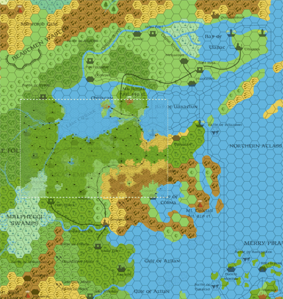
With the 8 mile grid overlaid on the 40 mile hex scale map, I noticed, because of the scale, the rivers are about 8 miles wide for the majority of their length. :D
Not really relevant, but it's just something I've never even thought about before.
Regards,
Gary

There are only a couple more Hollow World maps left to do now - Ashmorain and Shajapur from HWA2 and HWA3, and I
can't think of any others.
Regarding the rivers, that thought has occurred to me, yes. Especially on the smaller scale maps, the width of the rivers
is hugely exaggerated. Even on the large scale maps they are too thick. I've considered shrinking them down, but I
haven't tried it yet. I do want to standardise the widths at some point, though - currently on my maps there is some
variation between maps.
...the width of the rivers is hugely exaggerated.
I always assumed that the exaggeration was merely for purposes of clearity. It doesn't show any of the river's finer meanderings or width variations. I guess you could say it's a rough guide in the same manner that the hex symbols are a rough representation of the area's terrain.
That Azcan overlay map was very interesting there, Thorf. Really puts it in perspective, eh!
There are only a couple more Hollow World maps left to do now - Ashmorain and Shajapur from HWA2 and HWA3, and I
can't think of any others.
Are you also planning to do all the maps from the surface gazeteers or the Poor Wizard's Almanac?
RPGpundit
Are you also planning to do all the maps from the surface gazeteers or the Poor Wizard's Almanac?
RPGpundit
Sorry, I should have been clearer. There are still quite a lot of Outer World maps to do, mostly in the 72 mi per hex scale. But when it comes to the Hollow World, the sources are much more limited:
- Hollow World projection map, non-hex
- Northern and Southern Iciria maps, 40 mi per hex
- Azcan Empire map, 8 mi per hex
- Kingdom of Nithia Delta Kingdom and Southern Kingdom maps, 8 mi per hex
- Milenian Empire map, 8 mi per hex
- Ashmorain map, ? mi per hex
- Shajapur map, 8 mi per hex
- A few non-hex maps from the Poor Wizard's Almanacs
The Iciria map is a great source for developing the majority of the Hollow World, because it deals with so much ground. The 40 mi per hex scale turns out to be friendlier than the Outer World's 72 mi per hex scale, too.
I have great hopes that the projection map can be used to expand the Iciria map to cover the whole of the Hollow World, but unfortunately it doesn't seem to be as compatible as I had hoped. Still, it should be possible.
The 8 mi per hex maps cover only a small area of the world, but thanks to the 40 mi per hex map, they should be easily expandable.
Lastly, the Shajapur map is the only source we have for a non-Icirian area of the Hollow World, but unfortunately the hex grid is set at a 90 degree angle to the rest of Mystara's maps, so it will require some conversion. (The same problem appears occasionally elsewhere, most notably the Isle of Dread large scale maps in X1.)
I only wish the Outer World maps were as simply summed up in a few paragraphs, but the history of the world combined with the sheer number of sources makes the situation a lot more complex.
By the way, I can't check right now because I'm at work, but I don't think any of the Hollow World maps provided in the Poor Wizard's Almanacs give any new information. They tend to be useful as reference materials, though - for example I used the Traldar Kingdoms one to help resolve the continuity problems for that area on my combined map of Iciria. (The original Northern and Southern Iciria maps both show that area a little differently.)
But as far as I've seen the ONLY "changed" map of the hollow world would be to add the border and city for Alphatian Neatharum.
RPGpundit
I always assumed that the exaggeration was merely for purposes of clearity. It doesn't show any of the river's finer meanderings or width variations. I guess you could say it's a rough guide in the same manner that the hex symbols are a rough representation of the area's terrain.
I agree. You can see this in particular clarity with the 1 mi/hex map of Morlay-Malinbois in PC4: Night Howlers. The main river through there, by the large map scale, should also be gigantic, but it is pared down considerably in the 1 mi/hex format, and a lot of new tributaries (not visible on the larger scale) are also seen. Same thing occurs on the 1 mi/hex map of the Dreamlands from PC1: Tall Tales of the Wee Folk. That map depicts the southwestern edge of the Canolbarth, and has tons of little rivers and lakes that are not visible on larger scale maps.
(BTW, Thorf, I'm interested to see how/if you can reconcile the map of the dominion from CM8: Legacy of Blood with the Darokin map around the Dolos region. I've done some preliminary work, but nothing is quite satisfactory at the moment, as the moor from CM8 should not only be visible on the 8 mile/hex map, but Dolos is going to have to be moved a hex south somewhere... just mentioning it because it is close to the PC1 map, and now that you've exhausted the 8 mi/hex maps... heh, heh, heh.
The 8 mi per hex maps cover only a small area of the world, but thanks to the 40 mi per hex map, they should be easily expandable.
The Hollow World maps have been pretty consistent, I've found, as far as matching the 40 mi/hex map. Certainly compared to the outer world maps.
I've done some maps of the other regions of the HW, notably the Hutaaka Valley, or as we called it in the Hutaaka Gazetteer, the "Valley of the Dogs."
There is a problem with those maps, though- since I did them in pieces, when I was shifting hex maps to get another section, I displaced them by a hex or two- and I haven't ever gotten back and fixed it.
Lastly, the Shajapur map is the only source we have for a non-Icirian area of the Hollow World, but unfortunately the hex grid is set at a 90 degree angle to the rest of Mystara's maps, so it will require some conversion.
You can use my map of Selhomarr to map out Suridal. My map covers the central third of the continent at 40 miles per hex, as well as part of the Icirian peninsula that almost touches it.
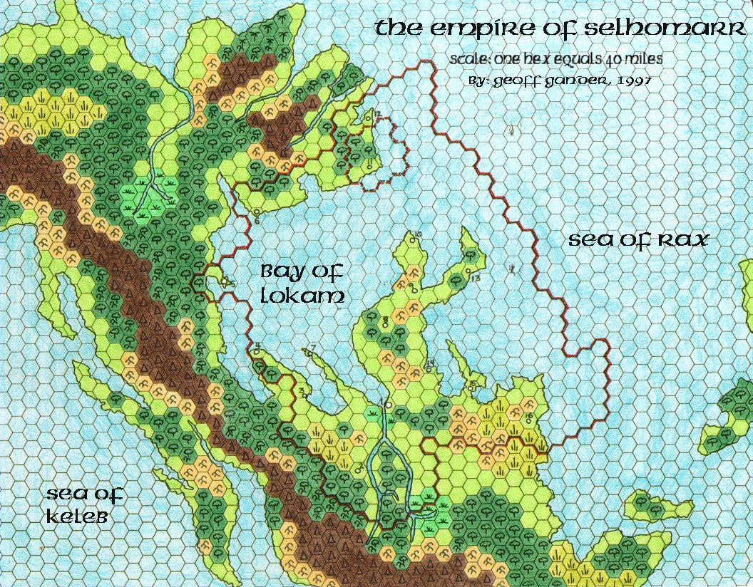
Geoff
Do you have any without gridmarking or towns?
I need to stop by here more often.
The Seabed of dread map will help me out a lot for my currenty mystara homebrew, THANKS.
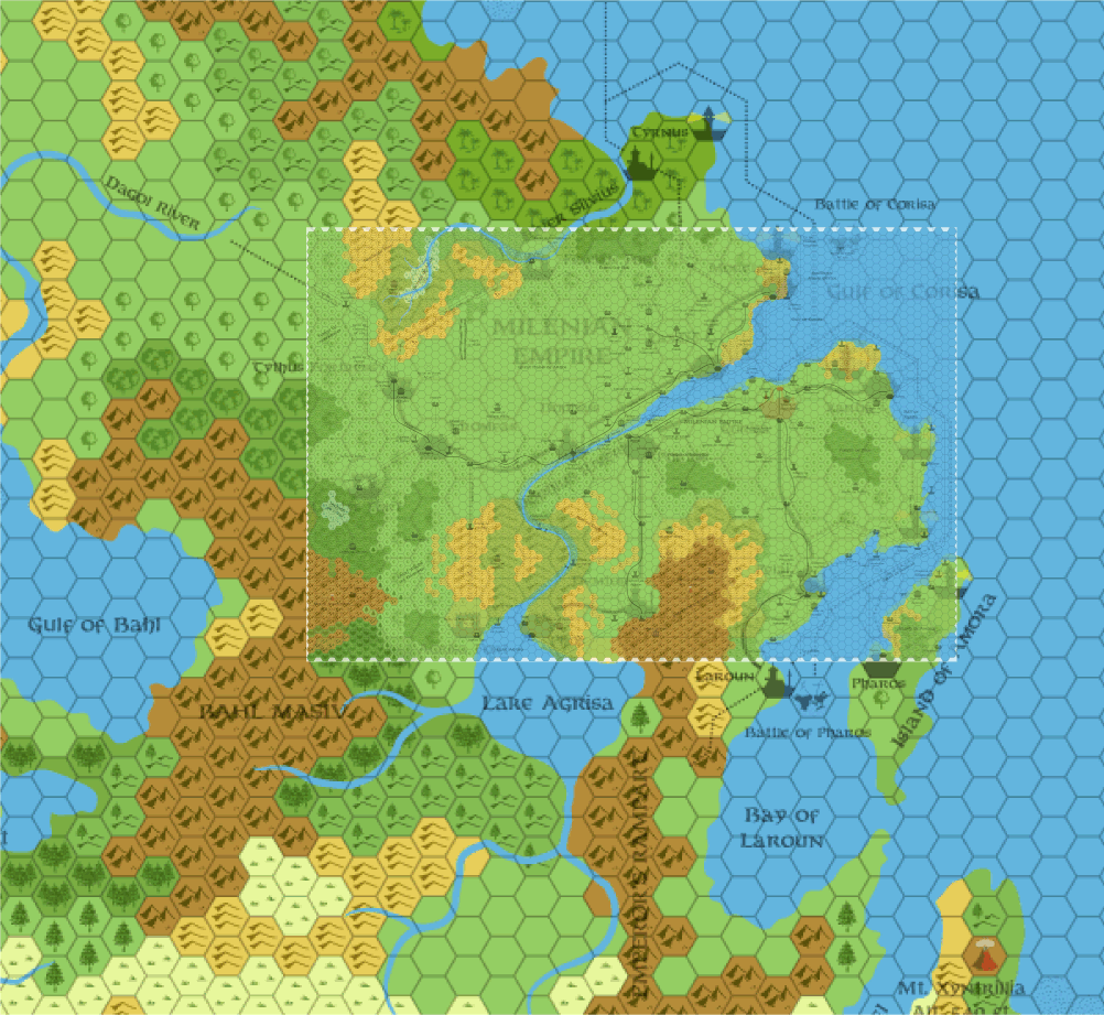
More replies later.
There is a problem with those maps, though- since I did them in pieces, when I was shifting hex maps to get another section, I displaced them by a hex or two- and I haven't ever gotten back and fixed it.
As it happens, I had already seen your very nice Hutaaka maps, but I wasn't aware of the HWR. Great work! It's really interesting how it ties in with the Lupins and Gnolls, and it pushed me to finally get round to reading the Lupin article in Dragon 237.
Anyway, I put together another overlay, this time using your Hutaaka maps. I don't see any problems with them, though. Did you mean because they overlap, or what?
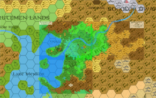
It looks like it will be extremely easy for me to remake your Hutaaka maps into a full map of the area.
Anyway, I put together another overlay, this time using your Hutaaka maps. I don't see any problems with them, though. Did you mean because they overlap, or what?
For some reason, I got it into my head that I'd messed up a bit around the island in the bay there, and threw off the rest of the maps. I guess I didn't after all, which is nice to know.
I really love these overlays that you've done- they really put things into perspective.
On another note, I do have a fourth map (of the Wulven valley) that I never did get around to posting up- because I hadn't completely developed that region. I should dig it out and see if I ever did complete it.
I'd love to see your Wulven Valley map, Andrew, even if it's incomplete. We'll have to work on some names for the unlabelled settlements, too.
By the way, I notice that you designed a new symbol. What does it represent? It looks like a mud hut to me.
Anyway, I put together another overlay, this time using your Hutaaka maps. I don't see any problems with them, though. Did you mean because they overlap, or what?
Wow! Andrew, you really did an excellent job there! Kudos to you, and I'll second Thorf on wanting to see your map (even an incomplete one).
Geoff
Anyone got any ideas? Do the gnolls prevent the dwarfs from going that way? That could work for the present, but the gnolls are a relatively recent arrival...
I'd rather find some sort of expanation rather than just ignore the trail altogether.
Hmm, I just noticed that there's a trail/mountain pass leading from the Kogolor town of Bergholm to the Gnollheim Hills. It seems to conflict with the official info on the Hutaakans, as well as the Hutaakan HWR, neither of which mention contact with the Kogolors.
Anyone got any ideas? Do the gnolls prevent the dwarfs from going that way? That could work for the present, but the gnolls are a relatively recent arrival...
I'd rather find some sort of expanation rather than just ignore the trail altogether.
This is not official but I just had this rough idea:
Maybe that trail is haunted similar to the one in LotR. It is populated by a strange evil variaty of spectres that nearly was extincted by a LG church a few centuries ago.(any ideas for details?)
Having started to like these undead, the Immortal Nyx chose to save a portion of them and transported them into this secret trail where they lurk for any travelers who dare to enter their land.
I'd love to see your Wulven Valley map, Andrew, even if it's incomplete. We'll have to work on some names for the unlabelled settlements, too.
I think those were all gnollish camps that I never came up with names for. Probably should just be named after the individual gnollish tribes that inhabit them. There might be some lupin camps, too.
I actually wanted to put more Hutaaka settlements in the valley, because it seems odd that there wouldn't be more hutaaka there after all this time, but the population figure given for hutaaka in the HW DM's guide is incredibly low, and I went with Mischa's argument that the hutaaka themselves were pretty self contained on that little peninsula there. I still think even there we should see a bit more, but...
By the way, I notice that you designed a new symbol. What does it represent? It looks like a mud hut to me.
Oh yeah- it's a mission, where the hutaaka have set up missionaries among the lupins.
Hmm, I just noticed that there's a trail/mountain pass leading from the Kogolor town of Bergholm to the Gnollheim Hills. It seems to conflict with the official info on the Hutaakans, as well as the Hutaakan HWR, neither of which mention contact with the Kogolors.
There isn't much mention of it in theKogolor HWR either. I'd assume that, given that the gnolls (as we have it) are a recent arrival, they don't conflict much with the dwarves.
Since there really isn't much in the valley, I'd guess that trail is just one the dwarves use occasionally when/if they need to trade or interact with the hutaaka. Since there is no mention of contact between them, it's probably safe to say such contact is rare, but that the dwarves nevertheless keep that route through the mountains open and patrolled.
It's probably a small valley where dwarves live- given that the Kogolor live above ground, rather than beneath it. They might have some fortresses through there that are only visible on a larger scale. Surprised I didn't actually do something with it myself, when I did the maps. I did start a couple of Kogolor maps, continuing from the valley, which I would have put a bit more detail into. I think I forgot about that trail entirely.
As an aside, I was planning on further detailing the Burrower beneath Yoht in my "Meet the Burrowers" articles on the Vaults. IIRC, the one beneath Yoht was going to be either a mutated Brain Collector Burrower or else a Deep Glaurant Burrower. I can't recall which, exactly. Pretty sure it was the former, though.
(I also plan/ned to have the two Burrowers in Nithia, the "towers" of Soth and Sekhaba, be incubus and succubus burrowers. And the cipactli beneath the Azcan lands was going to be a very interesting type of creature. I got hung up on statting them, though, because I wanted to do them in 3E style. I should just go back and do them OD&D style for now, though, just to have them done...)
That sounds like a cool idea for that trail. Maybe in the distant past there was an attempt at contact between the two but something happened; a betrayal perhaps that killed many on both sides and now the dead jealously guard the trail from 'traitors' (read as anyone) that try to use it.
It could also be somehow connected with the Burrower that corrupts the dwarves in Yoht. Though it is a bit further from Yoht, there could still be some connection. Maybe as the altitude decreases from the heights of Bergholm to the valley, the underground, twisted, minions of the Burrower are closer to the surface and more likely to hunt there?
the replica map from the Master Set, is it possible to get the Illustrator file for that? I'd like to do something with the linework and if you've already got that in the file then it can save me recreating it.
It looks like holidays as there are few answers... Lucky guys ;)
I updated my website so every Thorf awesome maps are there.
You can download zip file with thumbnails (maybe those aren't updated) and enjoy Thorf great job.
The URL : http://huguesjoneaux.club.fr/MTM/
Greetings.
Ps: I'm sorry for those who are using IE, the website shouldn't be so great. I'm working on it.
I will definately find some use for these maps in my own ongoing projects!

Any chance of a 8 mile hex map of Glantri post WotI, or least the Great Crater, sometime soon?
Regards,
Gary
Any chance of a 8 mile hex map of Glantri post WotI, or least the Great Crater, sometime soon?
Here's one that I did several years ago (1998! Yeesh...)
It's a very old palette, the colors are too bright, and it's based on the changes I implemented in the Great Crater mini-gazetteer that I did a long time ago.
I've only ever partially updated the map with my new hex templates, and I never quite finished the maps of the underground (two different levels), but it's a start. Maybe Thorf will take a run at updating this map when he finishes the rest of his official maps.
This is not official but I just had this rough idea:
Don't worry about that - every idea we have about these largely undeveloped areas is not "official", it's more a matter of trying to keep them in line with what little official stuff we do have. And even then, sometimes it's better to ignore or change the official stuff if it is unworkable.
Maybe that trail is haunted similar to the one in LotR. It is populated by a strange evil variaty of spectres that nearly was extincted by a LG church a few centuries ago.(any ideas for details?)
Having started to like these undead, the Immortal Nyx chose to save a portion of them and transported them into this secret trail where they lurk for any travelers who dare to enter their land.
That's a pretty cool idea! It would certainly prevent the Kogolors from having contact with the gnolls, lupins and hutaaka, while also presenting a very interesting adventure for PCs who wish to take that pass to get from one region to another.
The race itself doesn't have to be unique, rather it could be a community of undead with a specific culture that was in danger on the surface world. (Undead have culture?!? ;))
Actually another reason that this is interesting is that it would be nice to see some more cultures preserved by Entropic Immortals. Although preservation is somewhat against their principles, transferring entropic communities to the Hollow World would be a very good way to forward many of their plots.
I think those were all gnollish camps that I never came up with names for. Probably should just be named after the individual gnollish tribes that inhabit them. There might be some lupin camps, too.
Okay. I guess I'll remake your map and make a new thread for this subject sometime soon, and we can fill in all the missing names and stuff then.
I actually wanted to put more Hutaaka settlements in the valley, because it seems odd that there wouldn't be more hutaaka there after all this time, but the population figure given for hutaaka in the HW DM's guide is incredibly low, and I went with Mischa's argument that the hutaaka themselves were pretty self contained on that little peninsula there. I still think even there we should see a bit more, but...
I agree with you. Was the explanation for the hutaaka being so few in numbers related to the way they don't always breed true? I can't quite remember how it worked.
In any case, personally I would disregard the official figures and add quite a bit more hutaakans. Official population figures have been drastically revised before, I believe.
Oh yeah- it's a mission, where the hutaaka have set up missionaries among the lupins.
Cool. It's a nice little symbol, I'll have to remake it when I do your maps.
There isn't much mention of it in theKogolor HWR either. I'd assume that, given that the gnolls (as we have it) are a recent arrival, they don't conflict much with the dwarves.
Since there really isn't much in the valley, I'd guess that trail is just one the dwarves use occasionally when/if they need to trade or interact with the hutaaka. Since there is no mention of contact between them, it's probably safe to say such contact is rare, but that the dwarves nevertheless keep that route through the mountains open and patrolled.
I guess this would work too. I kinda liked the undead valley idea, though.
I don't suppose the Kogolors and the Hutaakans have much in common, actually, and therefore they wouldn't have much reason to stay in contact with each other. Trade is the only reason I can think of for them to interact, but maybe the Hutaaka don't have much that the dwarves would want - and I'm sure hutaakan haughtiness would not go down well with the dwarves.
It's probably a small valley where dwarves live- given that the Kogolor live above ground, rather than beneath it. They might have some fortresses through there that are only visible on a larger scale. Surprised I didn't actually do something with it myself, when I did the maps. I did start a couple of Kogolor maps, continuing from the valley, which I would have put a bit more detail into. I think I forgot about that trail entirely.
It's definitely a borderland type area for the dwarves, but in contrast with their northern border there are no major fortresses marked. I'd say that they might have a keep guarding the pass, but it should be a minor one - the safest and most boring assignment for Kogolor soldiers.
Of course, this could change with the arrival of the gnolls.
I've been planning to do a Kogolor map for quite a while, by the way. It should be a fun area to do, putting little valleys and such in among the mountains.
As an aside, I was planning on further detailing the Burrower beneath Yoht in my "Meet the Burrowers" articles on the Vaults. IIRC, the one beneath Yoht was going to be either a mutated Brain Collector Burrower or else a Deep Glaurant Burrower. I can't recall which, exactly. Pretty sure it was the former, though.
(I also plan/ned to have the two Burrowers in Nithia, the "towers" of Soth and Sekhaba, be incubus and succubus burrowers. And the cipactli beneath the Azcan lands was going to be a very interesting type of creature. I got hung up on statting them, though, because I wanted to do them in 3E style. I should just go back and do them OD&D style for now, though, just to have them done...)
Oohh, this sounds interesting. Where can I find your burrower articles, exactly? Did you do lots of stuff about them? I'd be very interested to read that.
It sounds like you have defined the burrowers as modified versions of monsters...?
By the way, biased though I am towards classic D&D, I would suggest that you forget the stats for the first pass and just do the descriptions. As far as I'm concerned the meat of any monster comes in its description, not its stats. Special abilities make less difference than you might think, too, especially since most really interesting abilities are included in the description anyway.
Any chance of a 8 mile hex map of Glantri post WotI, or least the Great Crater, sometime soon?
I've been thinking about doing that little adjustment for a while. I think I actually started on the map, actually - I remember adjusting some borders, because the dominion borders were changed in a few places for Glantri: Kingdom of Magic.
I'll try to get back to it soon. In the mean time as Andrew said, he did a very nice map of the crater.
Hey Thorf. I was wondering what program you're using to make these maps of yours and if there was a way I could get a copy? I was thinking of doing some mapping of my own.
I use Adobe Illustrator CS2 to do my maps. You can read about it here. I'm afraid that it's a rather expensive professional program, but as such it is extremely powerful.
I agree with you. Was the explanation for the hutaaka being so few in numbers related to the way they don't always breed true? I can't quite remember how it worked.
Yeah- that was the explanation we came up with to justify the low population levels.
I guess this would work too. I kinda liked the undead valley idea, though.
Could be a combination. Explorations to the south haven't encountered very much, and the additional aspect of the undead valley would simply be more reason for them not to want to explore and trade with the south. If there were something more worthwhile there, they'd try and do something about the undead.
I've been planning to do a Kogolor map for quite a while, by the way. It should be a fun area to do, putting little valleys and such in among the mountains.
Me too. The trails that are marked are a pretty good indication of where the valleys must lay at a larger scale, and it would be a pretty simple matter of filling in settlements and things along there. I think where I got hung up (as often happens) is with population figures. There just doesn't seem to be much room for "lesser" settlements outside of the ones shown, which would lead to a lot of empty space. Arrgh!
Oohh, this sounds interesting. Where can I find your burrower articles, exactly? Did you do lots of stuff about them? I'd be very interested to read that.
I've only done two so far, and you can read about them at the Vaults. There's an entry for Klarkaszh the Corrupter and D'resh the Destructor. D'resh has a direct connection to the Valley of the Dogs, as it happens.
It sounds like you have defined the burrowers as modified versions of monsters...?
Sort of. The way I have it, in life they were monsters of various statures, mostly of cultures/upbringings that were very anti-Immortal. Klarkaszh was a kopru and D'resh a carnifex, for instance, and both had reasons to dislike the Immortals and their ways. Thanatos found them, converted them to his side, and through a combination of Entropic magics and pacts with Outer Beings, created the Burrowers (the Greater Burrowers, that is).
I still haven't quite come up with a reason for him to have sicced them on the Hollow World rather than the Outer World, unfortunately. That part of the Hollow World history never really made sense, as there was nothing worthwhile in the HW to screw around with. The only beings there were the Brute-Men, and (with Geoff's additions to Mystara) the Lhomarr. So for Thanatos to unleash these creatures with the power to challenge the Immortals on an empty world... really doesn't scan.
By the way, biased though I am towards classic D&D, I would suggest that you forget the stats for the first pass and just do the descriptions. As far as I'm concerned the meat of any monster comes in its description, not its stats. Special abilities make less difference than you might think, too, especially since most really interesting abilities are included in the description anyway.
True enough. The two I have done are in the classic D&D format, fwiw. I should just sit down and do some descriptions and histories of the others that I have in mind.
I use Adobe Illustrator CS2 to do my maps. You can read about it here. I'm afraid that it's a rather expensive professional program, but as such it is extremely powerful.
Thanks Thorf. The link didn't work for me but I can find info on it with a quick search.
In any case, my brother is looking into it for me, and hopefully it'll be back up soon. In the meantime you can find all my maps on Shughuy's page at his link a few posts up this page.
Until the problem is resolved, most of the maps embedded in this thread will be offline, so please bear with me. Sorry! :embarrass
It seems my home page, http://www.thorf.co.uk, is down. It may have been down for as long as a month
Couldn't have been offline for very long. I think one of us would have noticed.
--Ray.
It seems my home page, http://www.thorf.co.uk, is down. It may have been down for as long as a month, but I've been so busy I didn't notice.
It's OK now. ;)
Regards,
Gary
I really don't know how long it has been down for, but there is actually a reason why perhaps no one noticed: the recent maps are all on a different server, because my home page server is full.
Yep, it's fixed now.......the recent maps are all on a different server, because my home page server is full.
As long as they are also kept on the Vaults, we won't loose anything. That's the most important part.
--Ray.
As long as they are also kept on the Vaults, we won't loose anything. That's the most important part.
Hehe. Don't worry about losing them, the PNG files online aren't the originals anyway, they're just exports from the Illustrator files, which I have here, with backups too.
The following Java program has this capability (although it doesn't use vector graphics so it's not as pretty as thorf's maps).
http://www.bifrost.demon.co.uk/comp/java/mapcraft.html
http://mapcraft.sourceforge.net/
Just a quick note to say that I'm not dead, nor entirely disappeared. ;)
I'm currently taking a bit of a break from mapping and stuff for the time being, but I will get back to things hopefully before too long. Lots is happening back home in Scotland right now, with illnesses and problems in the family, so I may go a little MIA for a while, but please don't worry.
I'll try and drop in from time to time to check on our progress!
Lots is happening back home in Scotland right now, with illnesses and problems in the family
Sorry to hear that, Thorf!
Best wishes,
Jesper
Hope the problems will be scattered away from your household as soon as possible, so you'll get back to pester us with your vicious posts! :P :D
Take care,
Marco
Hope everything is going well for you and your family - my prayers are with you.
Is it possible, when things are more-or-less straightened out and on the level, to get copies of the basic hexes you use in map design, blown up to about 60 pixels high and saved as bitmaps? I've got a sorta-kinda-related mapping project of my own, for which this would be quite helpful.
Thanks in advance!
Talking about Karameikos map, have you ever considered to add some of the minor villages and ruins shown in some official adventure modules?
Explicitly, here is what I found:
The village of Lunn:
X12 "Skarda's Mirror", page 42 (but also in some other places of the module)
Ashgarth was the son of a townman in the village of Lumm, a small community a few miles northeast of Kelven.
The whole village was kidnapped by Skarda some 20 years before X12 events (which is set in the 30th year of reign of Sthepen Karameikos, which means AC1000). It could be added as "ruins" or as "village" if you suppose X12 was already played and all the captives of Skarda are freed.
The village of Knosht:
GAZ5 "The Elves of Alfheim", page 41:
Boris Beerthumb is a native of Karameikos, a Traladaran. Boris was born in 965 in Knosht, a small farming village in the wooded foothills to the east of Treshold.
The ruins of Xitaqa:
B10 "Night's dark terror":
These hutaakan ruins are clearly shown on the B10 map, along with many other notes about humanoids positions and other notable sites (including the "village" of Sukinskyn).
My 5 cents, anyway.... ;)
This thread is really huge, so I'm not sure if these points were already discussed before.
Talking about Karameikos map, have you ever considered to add some of the minor villages and ruins shown in some official adventure modules?
Explicitly, here is what I found:
The village of Lunn:
X12 "Skarda's Mirror", page 42 (but also in some other places of the module)
Ashgarth was the son of a townman in the village of Lumm, a small community a few miles northeast of Kelven.
The whole village was kidnapped by Skarda some 20 years before X12 events (which is set in the 30th year of reign of Sthepen Karameikos, which means AC1000). It could be added as "ruins" or as "village" if you suppose X12 was already played and all the captives of Skarda are freed.
The village of Knosht:
GAZ5 "The Elves of Alfheim":
Boris Beerthumb is a native of Karameikos, a Traladaran. Boris was born in 965 in Knosht, a small farming village in the wooded foothills to the east of Treshold.
The ruins of Xitaqa:
B10 "Night's dark terror":
These hutaakan ruins are clearly shown on the B10 map, along with many other notes about humanoids positions and other notable sites (including the "village" of Sukinskyn).
Interesting stuff Michele!
I would add a few:
1) Haven, from B3. Although marked on several maps, it was never given a map symbol
2) Argos' Lair, from Who is who among Dragons.
3) The Village of Bywater from the Penhalgion Trilogy and Escape from Thunder Rift
4) Karameikan Armstead (IMC renamed Bronow), not to be confused with its Darokinian namesake, replaced by ruins of such in AC1010.
5)Eltan's Spring, from K:KoA
6) Grey Mountain, in Rablebb, from B4
7)Castle Caldwell
8) The Ruins of Mistlamere Castle, from tha basic set intro adventure.
Håvard
8) The Ruins of Mistlamere Castle, from tha basic set intro adventure.
By the way, the correct spelling is: "Mistlamere" or "Mistamere" (without "l")?.
The Italian translation of the Basic Set red box (single edition, very diffused) says "Mistamere".
Funny misspelling, anyway... :P
By the way, the correct spelling is: "Mistlamere" or "Mistamere" (without "l")?.
The Italian translation of the Basic Set red box (single edition, very diffused) says "Mistamere".
Funny misspelling, anyway... :P
Its probably Mistamere. The name was removed entirely from the Norwegian version entirely (along with a series of other cute spelling errors), so I'm only going with what I remembered from discussions on the web.
Oh, and another one: Stallansford from DDA1 & DDA 2, a village not far north from Penhaligon, as well as Illiana's fortress, from the same modules, located in the southeasternmost hex to the northwest of Penhaligon.
Also, it would have been nice to see a map indicating upgraded nobles after Stefan became King...
Håvard
Talking about Karameikos map, have you ever considered to add some of the minor villages and ruins shown in some official adventure modules?
I had this thought not so long ago, and began work on a 1 mile/hex map of Karameikos (in the vein of Morlay-Malinbois from PC4) to fill in exactly some of the areas you mention.
What I've found thus far is that... a 1/mi hex map of Karameikos is *huge* (or *yooge* as Donald Trump would say).
Also, that various map sources don't exactly mesh up with one another (B10, Gaz1, Expert set, and also the map in AC2: Treasure of the Hideous One, which is supposed to be set in western Karameikos somewhere).
The village of Knosht:
Missed that one, but I'll raise you the village in Treasure of the Hideous One (where Rosentos disappeared), and Eltan's Spring (from Karameikos: Kingdom of Adventure).
Oh, also Stallanford (from B11: Queen's Harvest), Bywater (from the Penhaligon trilogy), and possibly one or two others that I can't recall offhand. There are actually a lot of little homesteads and villages/towns in various products for Karameikos at least.
Also, it would have been nice to see a map indicating upgraded nobles after Stefan became King...
Oddly, it seems Stefan never got around to promoting any nobles after becoming King, at least according to K:KoA (which has everyone pretty much in the exact same positions, with the exception of Zandra Sulanov, who is promoted to Minister of War after Lucius Hyraksos' death seemingly out of the blue- and in opposition to the promotion of same to Sir Retameron Antonic in one of the PWAs- 1011, I think. The only thing I figure is that Retameron filled the spot temporarily, until it was permanently assigned to Sulanov.)
It seems strange that, at the very least, Mistress Sascia wasn't granted Luln as her barony (since she is mentioned as being under the Duke's eye for such)- after 13 years, she should have gotten something. Similarly, I wonder that other already landed nobles weren't promoted to baronies, and existing baronies upgraded in status.
Talking about Karameikos map, have you ever considered to add some of the minor villages and ruins shown in some official adventure modules?
Wonderful additions so far!
My little contribution: ;)
- Irenke, a village north-west of Penhaligon which hosts some retired adventurers, from Joshuan's Almanac;
- Highdell, the mining community situated north of Threshold, from D&D Expert set (blue box) - disappeared from later products;
- Arkayz's Manor, from B8, and the surrounding area with woods and mountains, which is said to lay north/north-east of Threshold, on the Cruth/Black Peaks range (confirmed by B1-9);
- The ruined monastery on The Hill and Guido's Fort from B5 (with Shrill River, IIRC), which according to B1-9 is set north-west of Haven;
- Elwyn's castle east of Threshold and Black Eagle Outpost at eastern border of von Hendriks' barony, both from B9;
- Sisak village, from Dungeon #24 ("In the dread of night"), located along the Westron Road;
- Sir Reynard's fief and the small town of Utica from Dungeon #42 ("Ransom"), located in the Threshold region;
- Seragrad town, located in the point there the Castellan River joins the Highreach River, from Dungeon #59 ("Voyage of the Crimpshrine");
- Bargle's Dungeon from D&D Basic set (red box), where the unnamed hero meets Bargle for the first time in D&D; probably they're located near Threshold.
Moreover:
6) Grey Mountain, in Rablebb, from B4
Are you meaning the Grey Mountain with the temple where is to be found the Rahib of B7? If so, we've also the near elven village of Kota-Hutan, where Rahasia is kindnapped in that adventure.
I think however the B7 is set east of the Duke's Road, before it begins to climb the mountains; in fact, in B1-9 says the PCs get there while travelling to Selenica, following a near-hidden path in the middle of the forests that heads east of the road (probably forested hills, according to Thorf's new map of Karameikos ;) ).
Moreover, GAZ1 says the Callarii communities are found mostly in the Radlebb Woods and in the forested hills south of Highforge, but also that many more elven villages lays in the Karameikan wilderness.
I had this thought not so long ago, and began work on a 1 mile/hex map of Karameikos (in the vein of Morlay-Malinbois from PC4) to fill in exactly some of the areas you mention.
That would be great!
Are you going to post it somewhere as soon as it's finished?Oddly, it seems Stefan never got around to promoting any nobles after becoming King, at least according to K:KoA (which has everyone pretty much in the exact same positions, with the exception of Zandra Sulanov, who is promoted to Minister of War after Lucius Hyraksos' death seemingly out of the blue- and in opposition to the promotion of same to Sir Retameron Antonic in one of the PWAs- 1011, I think. The only thing I figure is that Retameron filled the spot temporarily, until it was permanently assigned to Sulanov.)
I orginally considered this a flaw of K:KoA, but I think its better to apply your perspective that he just hasn't gotten around to it yet, by AC1013. It seems like the most likely next step though, and the fact that he hasn't done so yet is likely to make some people unhappy...
Perhaps it is a strategy to figure out which nobles are really loyal to him, after he finally realized what was going on with the Black Eagle.
It seems strange that, at the very least, Mistress Sascia wasn't granted Luln as her barony (since she is mentioned as being under the Duke's eye for such)- after 13 years, she should have gotten something. Similarly, I wonder that other already landed nobles weren't promoted to baronies, and existing baronies upgraded in status.
I agree. IMC the reason could be that he wants to give this area to one of his sons when he is old enough, to compensate for the older son (Justin?) becoming the next king. IMC, daughters cannot inherit the throne, and Adriana's marriage to Hyraksos was probably arranged to strengthen Stefan's alliances within the Traladaran population. Queen Olivia has other plans however.
Form the game designers perspective, it seems more likely that Sascia was passed over to make Halag a possible Barony to be awarded to the PCs. This is suggested quite explicitly in the adventure booklet that came with K:KoA.
I think it makes the situation quite interesting, and I imagine Sascia is now quite bitter that the King didn't listen to her even now after ignoring her pleas concerning the Black Eagle during all those years...
Håvard
elven village of Callanya
It is described in one of the PWAs (PWAIII, I think), it should be somewhere in the forest, west of Rifflian. I think it is destroyed by a forest arson in 1012DI, forcing its inhabitants to leave.
elven community of Kavva Lindnenem
She is an elven pregenerated character in M5 "Talons of Night". She comes from "a small elven community exiled in the westernmost forest of Karameikos". She also adventured in Norwold, where her mate was killed by humans.
She wears very ancient elven weapons and armory, "valued hundred of thousands of gold pieces". If these obejects come from her village, maybe this elven community is more powerful than it seems...
I know he hasn't quite worked his way to some of the smaller maps or maps from modules and such, but the map of the Domain of Fenhold from CM9: Legacy of Blood is inconsistent with the map of Darokin. The location of Fenhold, as given in the module, would place it in the same 24 mile hex that Dolos appears in on the 24 mile hex maps (in particular, the Wrath of the Immortals map I'm currently looking at).
As to how that would affect the 8 mile/hex maps, it seems that Dolos should be moved down a hex, and the hex above it changed to swampland. The trade road should be redirected southwards through Dolos (with a trail appearing in the space where it currently runs, cutting around the swamp).
This would seem to fix the problem with a minimum of fuss, and would explain why the larger (more visible) town of Dolos would appear in its current hex at larger scales (it is still very close).
(Seems to be a problem with the cartographer of Gaz11, published in 1989, not cross-checking with CM9, published in 1987.)
Updated 8-mile hex map #18 - Orc's Head Peninsula
Updated 24-mile hex map #3 - Arm of the Immortals
Replica 24-mile hex map #12 - Orc's Head Peninsula
Figured I should mention them or you may never find out! :D
Reporting some broken links from the indexed post #1:
Updated 8-mile hex map #18 - Orc's Head Peninsula
Updated 24-mile hex map #3 - Arm of the Immortals
Replica 24-mile hex map #12 - Orc's Head Peninsula
Figured I should mention them or you may never find out! :D
These aren't actually broken links. It seems that these boards have a problem with links that include apostrophes, which all three of these files do. If you manually edit the URL rather than clicking "Continue" at the "You are leaving wizards.com" page, you will see that the files are in fact present.
I agree it's a bit of a pain, though. I should probably just delete the apostrophes from the filename.
Incidentally, has anyone heard from Shughuy? His page seems to have disappeared. I was going to ask him to let me steal his HTML coding so I can update the map pages on my own - which is currently very much out of date.
While we're here, I have been considering once again the benefits of providing PDF files of my maps rather than (or in addition to) PNGs. But I don't have the server space to do both on a permanent basis. Maybe we could put them on the Vaults...?
These aren't actually broken links. It seems that these boards have a problem with links that include apostrophes, which all three of these files do. If you manually edit the URL rather than clicking "Continue" at the "You are leaving wizards.com" page, you will see that the files are in fact present.
Ahhh! Thanks, Thorf.
Incidentally, has anyone heard from Shughuy? His page seems to have disappeared. I was going to ask him to let me steal his HTML coding so I can update the map pages on my own - which is currently very much out of date.
Nope. Sorry.
While we're here, I have been considering once again the benefits of providing PDF files of my maps rather than (or in addition to) PNGs. But I don't have the server space to do both on a permanent basis. Maybe we could put them on the Vaults...?
The ones on the Vaults are PNG files. Maybe you could have the PDFs done in 'sets', like "Known World", "Alphatian Sea", etc. or something along that line. Or, organized as they are in the index; "replica 8-mile", "updated 24-mile", etc.
Actually, may I suggest that the Darokin maps automatically include the Alfheim map? the work has already been done, and it gets rid of that ugly white hole on the map.
I know that it sounds like an extremely simple and easily implemented suggestion, but unfortunately that is not the case. I have been trying to find a good way to work around the myriad problems of making maps that feature parts of other countries for over a year now, with not a lot of success.
I could of course paste Alfheim in there right now - that part isn't hard. But then I would have two versions of Alfheim to update, in two separate files. Moreover, the more hexes in each map file, the slower the editing process. Darokin is already a little slow, and it would only get worse if I added Alfheim.
I have tried linked files, but it's messy and problematic, surprisingly hard to set up properly, and still slows things down of course. I've thought about adding featureless versions of surrounding countries, as many of the Gazetteer maps themselves did, which would work, but I'm not sure I want to do things that way - and it would slow down the maps, of course.
Another solution would be just to permanently merge the Alfheim and Darokin maps, of course. In that case alone, it might work without much problems, but what about the rest of the area? I can't merge all the maps, and yet they fit together in such a way that it's impossible to have them showing in each other's files without duplicating stuff.
At one point I had a great idea, which was to make trail maps by pasting lots of linked files into a new file. That way, I could update the individual files, then clip the individual country maps from a larger image. This has been my best plan so far, but unfortunately the attempt failed when I found that Illustrator didn't like dealing with so many large linked files.
Of course some of these issues are related to my computer, so increasing my memory, for example, might help a bit. But that is not something I can do just now, unfortunately.
If anyone can think of a good, workable solution, I will be extremely happy. ;) I will continue to search, but it might take a while.
So Thorf, have you managed to get any futher with the Wendar map/Gaz?
Cheers,
LJ.
Sorry i haven't give any news from a while neither.
My website is down, cause i changed my ... (i miss the english word), you know the organisation which grants you access to the Internet (FAI in french).
Moreover, i subscribed to the topic and had no news... But, i'm back. I saw Thorf you were looking for the HTML codes. I'll try to make a zip with everything and put it somewhere you can get it. However, i think i will put back on the Internet all your files and the nice structure made once.
I'm glad to see the discussions starting again...
By the Way... Happy New Year :D
Happy New Year to you too! Nice to hear from you again.
So you changed your Internet service provider? I see.
I have been working on a little mapping again. Which reminds me - thanks everyone for the comments/suggestions/corrections in this thread on the last page. Don't worry, I haven't forgotten you completely, I'll get to instituting corrections sooner or later.
The good news is that I am getting towards finding a workaround for the problems discussed on the last page about showing neighbouring nations on each map. I hope I can get things finalised soon, so keep an eye out.
New maps will be posted to the end of the thread, but you might also want to check out the first post in the thread for updates.

Still, this map is interesting. It seems that Bruce kept most of the old landmarks and place names in his redesign.

the 6 mile per hex map of the Isle of Dread in X1.) HWA3's map has one saving grace, which is that, though
the hexes are angled the wrong way, the art is the same as normal. In other words, they just made the top
of the hexes west, rather than rotating the art inside the hexes (as X1 does...).
But I still hate it.
First, the map:

Next, here is a clear graphical rendition of why this map drives me mad - in case anyone couldn't work out
what I've been going on about.

I swear, by the time I'm finished those strange hex patterns are going to be etched into my mind. I'll probably
have nightmares about them.
In the interests of accuracy to the original maps, you mispelt "harbor" on the Savage Coast map.
Hehehe. That's the automatic spellchecker in my head at work. ;)
Take a look at the new format on the Alfheim and Darokin maps. It's extremely time consuming to do (i.e. it takes a lot of computer chugging and waiting), but the results are not bad. I will probably tweak things a bit more before settling on a final format, though.
You show a town in Alfheim named "Ainsu". I'm no expert by any stretch of the imagination, but I thought the name was "Ainsun". Which is right?
BTW, have you updated the Legend since changing your palete?
Love the new maps!
Gordon
You show a town in Alfheim named "Ainsu". I'm no expert by any stretch of the imagination, but I thought the name was "Ainsun". Which is right?
Good catch, Gordon. It looks like I made a typo on my original map, because as you say all the sources have Ainsun.
Strangely enough, yesterday I too found a similar error on one of my maps from early last year - Glantri had "Huldeain Camp" instead of Huledain Camp. It's funny that no one saw these until now, because the maps have been around for more than a year.
Anyway, corrections are always welcome. Thanks!
BTW, have you updated the Legend since changing your palete?
Love the new maps!
I don't think the Legend has been updated for quite a while. In fact I bet it doesn't even have the Milenian symbols from HWR3. I'll try and do it soon. I also should really do legends for a couple of other maps, too - I've been stalling on them for way too long.

...and added this other one...

...and this one.

The latter I have not really started to use yet, but I may decide to in the future.
You can then use the symbol originally used for "Capital" in a black rather than red color as "Large City" or "Metropolis" of 50,000+. In a case where it is also the capital, of course, then it would also be red, not black...
But it was a bit irritating having to redo all those plateaus and salt marshes. (They take hours to do. Literally.)

Please go ahead and compare the two maps, and tell me what you think.
With your cleaned and updated maps, perhaps you can switch out the symbol for the Capital of a state for the normal symbol for a settlement of its size, but colored red instead of black. Thus, you can tell at a glance that not only is it the capital, but also what size of settlement it is...
You can then use the symbol originally used for "Capital" in a black rather than red color as "Large City" or "Metropolis" of 50,000+. In a case where it is also the capital, of course, then it would also be red, not black...
I have considered doing just that. In fact at one stage I tried it out on the familiar Gazetteer maps. But somehow it changes the feel of the maps in a way that I don't like. And it makes the present capital symbol rather rare, too.
If I were mapping a new world from scratch, I would probably want to go with a system like that, but for Mystara I am sticking to the old capital symbol. For now.
I will certainly keep it in mind for a variations series, though. People seem to like having some choice, though I don't have the server space to maintain a lot of variations permanently.
Anyway, thanks for the suggestion.
Hmmm... I still wonder what stage II is...
Håvard
Lovely maps as usual Thorf! Seeing these on these boards on a monday morning made it easier to get this week started. Truly inspirational!
I concur - it even made me forget my cold for an hour or so. :D
Hmmm... I still wonder what stage II is...
Maybe an interactive map, were if you click on a place it would bring up a gazeteer type entry for it?
Anyway it's great to see new maps, Thorf. :D
Regards
Gary
Did you ever get a copy of the Baldur font from the Mad Irishman with accented characters?
If not I may just have to bite the bullet and buy and modify the existing font. I did something similar with a Dalelands font -adding accented characters and fractions etc.
Regards
Gary
Thorf,
Did you ever get a copy of the Baldur font from the Mad Irishman with accented characters?
Gary... As I fianlly crawl off to bed, you are definitely not popular with my wife tonight. Or should I say this morning.
...or at least that's as it should be - she doesn't know it's your fault, unfortunately. :P

(This one is not quite finished... Still needs a couple of trails and some tweaking.)
Check out the first page index for the rest! (And there are quite a few, though they are basically just components of this one.)
When I originally did my Princess Ark maps, I didn't have access to Red Steel at all, and although I had two copies of each map from Dragon, both were reasonably low quality scans - one from Thibault's site, the other from the Dragon PDFs. This meant that it was impossible for me to check (or indeed read, sometimes) many of the names, and so a huge number of mistakes crept in.
Amazing that no one noticed. But then again, most of them involved miscellaneous villages and other locations, so no one would notice the difference unless they did a direct comparison.
Incidentally, I actually have had the updated font for quite a while now (Patrick from Mad Irishman Productions came through for me!), but it's such a huge job adding in all those accents that I had almost nothing posted yet.
As such, don't expect to be seeing the rest of the maps all that soon, okay? I imagine there will be just as many mistakes, so the whole lot will need checked.
Well, that really is all from me. Good night!
Gary... As I fianlly crawl off to bed, you are definitely not popular with my wife tonight. Or should I say this morning.
...or at least that's as it should be - she doesn't know it's your fault, unfortunately. :P
 Oops! Sometimes I forget about time differences. :embarrass
 Its good to hear about the updated font though, I really should get round to buying it. In fact...
Regards
Gary
Its good to hear about the updated font though, I really should get round to buying it. In fact...
Ditto. Where can I get this thing?
Håvard
Ditto. Where can I get this thing?
Try here
Regards
Gary
Anyway it's only $12 or so, right?
In related news, I recently obtained a copy of Furst, which is one of the other fonts quoted on the TSR Font FAQ page. We know that the original font was Feinen Bold, but that site also lists FC-Feinen and Furst.
In any case, I am not sure about the legality of this font, since someone sent it to me, which is almost certainly not legal. But it's interesting to see the difference between it, Baldur, and the Feinen (as shown on the original maps). They are ever so slightly different. Also Furst includes a non-bold version, which I'm not sure I had seen before.
I will continue to use Baldur, though, since I know that it's legal. Well, assuming that clones are in fact 100% legal, that is... Fonts are such a tricky business, and I really don't know how the law applies in these cases.
Hmmm... I still wonder what stage II is...
Maybe an interactive map, were if you click on a place it would bring up a gazeteer type entry for it?
What indeed? ;)
Gary, your idea is not all that far off, really. But I'm thinking more along the lines of a book format than an interactive format.
Obviously, the subject involves maps heavily, but it's more than just that. :D
A word of caution - I don't think Patrick has updated the font that he has for sale yet. If you're interested, I would suggest that you send him an e-mail asking about it. It doesn't matter if you do it before or after buying it, although being a paying customer might give you more leverage. ;)
I'd downloaded the font from Myfonts just before you posted, and no it hasn't been updated yet. I've also sent Patrick an email.
Anyway it's only $12 or so, right?
or £7 in proper money. ;)
In related news, I recently obtained a copy of Furst, which is one of the other fonts quoted on the TSR Font FAQ page. We know that the original font was Feinen Bold, but that site also lists FC-Feinen and Furst.
Now if it wasn't illegal I'd...
Of course if I win the lottery then its Feinen Bold all the way.
I will continue to use Baldur, though, since I know that it's legal. Well, assuming that clones are in fact 100% legal, that is... Fonts are such a tricky business, and I really don't know how the law applies in these cases.
I think clones are okay as long as they aren't identical copies.
Regards
Gary
I'd downloaded the font from Myfonts just before you posted, and no it hasn't been updated yet. I've also sent Patrick an email.
He specifically asked me not to distribute it, or I would update you myself.
or £7 in proper money. ;)
Yes, otherwise known as 1400 yen for me. I work in pounds and yen, generally, but dollars are easy enough to work out too. ;)
Now if it wasn't illegal I'd...
I'm pretty sure Furst is a foundry-owned font, so the copy I got sent is dodgy indeed.
Of course if I win the lottery then its Feinen Bold all the way.
Gary, if you win the lottery, you can buy us a multiple user licence. :D I'll pay you back for it in the form of new maps. ;)
You might remember that we seriously discussed the possibility of buying it earlier in this thread. I'm still up for it if we can find enough people to get the price down.
I think clones are okay as long as they aren't identical copies.
I'm not so sure. At best they are probably a very grey area.
Let's face it, they definitely take money away from the original font creators. That alone makes them ethically questionable. In the end, they are copies of someone else's work.
Getting to have a look at Furst made me realise that even if we do eventually buy Feinen, we will probably be in for a let-down. The differences between Feinen, Furst and Baldur are so small as to be insignificant.
Anyway it's only $12 or so, right?
or £7 in proper money. ;)
Do you mean 10.25 ⁈ ? I'm not sure i got it ;)
By the way still awesome maps Thorf... So glad you're posting new ones. You did a great job on the 90°-turned one. Really great.
Do you mean 10.25 ⁈ ? I'm not sure i got it ;)
Hehe. Anyone else want to translate that for us? I'm sure there are people on the list who use other currencies still. ;)
By the way still awesome maps Thorf... So glad you're posting new ones. You did a great job on the 90°-turned one. Really great.
Thanks. It was quite hard work, though still pretty fun. It wasn't quite as hard as I thought it might be, although the inaccuracy introduced by the conversion is a little frustrating.
I wander which size it could be...
Go away silly idea... Go away before i'm back at home... Go away !!! :D
With the Gulf of Hule almost done, and Sind almost done too, that just leaves the Great Waste, and soon I will be able to make a series of connecting maps that run from the Western Isle of Dawn in the east to the Gulf of Hule in the west. That's going to be a pretty cool series of maps!
By the way, this is the 600th reply!

He specifically asked me not to distribute it, or I would update you myself.
That's OK - could you give us an idea of what he's added? Is it 'just' accented characters?
Gary, if you win the lottery, you can buy us a multiple user licence. :D I'll pay you back for it in the form of new maps. ;)
You're on.
You might remember that we seriously discussed the possibility of buying it earlier in this thread. I'm still up for it if we can find enough people to get the price down.
The trouble, I suppose, is that with 20ish people contributing we would then need a multi user licence. Which would bump the cose up.
I'm not so sure. At best they are probably a very grey area.
I presumed that it was OK, or Patrick wouldnn't be able to sell his clone. It's possible I suppose that he's had permission from the original creators.
Getting to have a look at Furst made me realise that even if we do eventually buy Feinen, we will probably be in for a let-down. The differences between Feinen, Furst and Baldur are so small as to be insignificant.
There is that as well.
And know I face the task of converting all my documents from Dalelands to Baldur.
Regards
Gary
Hi Gary,
Thanks for your support. I am almost ready to release a new version, so you should be able to upgrade at that time through myfonts.
Best regards,
Patrick
Regards
Gary
For those that are interested in the Baldur font, the following is relevant.
URL?
Håvard
URL?
Myfonts
or
Mad Irishman's Baldur font, more specifically.
It is http://www.thorf.co.uk/mystara/orc's-head-peninsula-8.png in the link, it should be http://www.thorf.co.uk/mystara/orcs-head-peninsula-8.png ....
I have to do new thumbnails since you updated and posted new maps... And i'm soooo glad to do it
Just to be annoying, in the first post of the topic, the 18th Updated 8-miles is a dead link.
It is http://www.thorf.co.uk/mystara/orc's-head-peninsula-8.png in the link, it should be http://www.thorf.co.uk/mystara/orcs-head-peninsula-8.png ....
I have to do new thumbnails since you updated and posted new maps... And i'm soooo glad to do it
Fixed! It was just the one link, right? I changed the filename but forgot to change that link. Thanks for catching it!
Shughuy, I would really like to copy your HTML and stuff on my site this time. We should have done it last time. Check your PMs!
Following will be the Red Steel-enhanced maps of the Central Savage Coast and Trident Bay areas. One is in progress, the other not yet started. Both will take a bit more time, though I might be able to post the former one later in the week.
I have some news: I am in the process of upgrading my web server, to give me more space and such. While this is happening, you may not be able to access some of my maps for a day or two.
After the new site is up and running, the conversion should be quite seamless, and in fact invisible to you. But the good part is that I will then be able to host more maps, and possibly other map-related stuff. Keep your fingers crossed.
In fact, I may not bother at all...

Thorf these maps are awsome,its my dreams of 20 years ago come to life. But I was wondering if you would update a map of old averoigne from X2?
Your wish is my command! :D

It's a pretty simple map, so it didn't take long - only an hour or two. Most of that was spent on rotating the symbols, since this is the first map I have done where the symbols are orientated differently within each hex.
I'm considering revising the map to include some heavy forests, as well as of course converting it to the usual flat-topped hex orientation, as I did with the Shahjapur map. It would be relatively easy to change the scale to 8 miles per hex at the same time.
Vote today! Thorf for Secretary-General of the U.N.!
lol
hey wait, the UN already has enough map makers, once my job becomes permanent then we can see about getting some more
Shughuy has been busy making a new interface for browsing my maps, and you can now find all the latest versions there.
Aside from the maps part, most of the links are still broken, but I'm going to be working on them as and when I find the time. Additionally, though I have fixed the index in the first page, the maps appearing on other pages in this thread will all be broken links until I can get round to updating the new URLs.
In the meantime, I have a little bonus test for those of you who are interested. I have uploaded the first five Gazetteer countries' maps in PDF format. These can be viewed in Acrobat Reader, and unlike the PNG files they will stay sharp however much you zoom in. Moreover, if you have Illustrator you can actually load them up and edit them there.
Please let me know what you think. If these are popular, I am considering uploading the whole series.
PDF Maps
Karameikos
Ylaruam
Glantri
Ierendi
Alfheim
Please let me know what you think. If these are popular, I am considering uploading the whole series.
Very nice Thorf, consider this one vote for uploading of the series. :D Would that just be the Gazeteer maps or all the maps you have done (eventuall)?
One minor problem is the WotC redirect page. It makes it a pain downloading the files to save. You can't just right-click and save link etc. And if you left click and load the map there is no save option under file. What I did was to copy the links to a 'dummy' post on the Enworld boards, previewed it, and then right-click and save target. There must be an easier way than that.
Thorf
You are aware that the Timeline, Projects & Articles, Characters, and Links links don't work yet? Or the Thorf & Kika and Links links on the main page.
Regards
Gary
Please let me know what you think. If these are popular, I am considering uploading the whole series.
Oh wow - now THIS is what I've been waiting for! :D
The files look absolutely great in pdf format, and as I have the full version of Acrobat I can zoom in and then save as a jpeg.
If only there was some way of getting Illustrator cheap so I could edit the files directly!
Very nice Thorf, consider this one vote for uploading of the series. :D Would that just be the Gazeteer maps or all the maps you have done (eventuall)?
I might not end up posting all my maps, due to space issues, but we'll see. Unfortunately the new style as shown on my Alfheim and Darokin PNG maps is not an option for the PDFs, so I am considering other ideas again.
Eventually I hope I can at least have a set of my updated maps online as PDFs.
One minor problem is the WotC redirect page. It makes it a pain downloading the files to save. You can't just right-click and save link etc. And if you left click and load the map there is no save option under file. What I did was to copy the links to a 'dummy' post on the Enworld boards, previewed it, and then right-click and save target. There must be an easier way than that.
If you have the latest version of Adobe Reader, there should be a "Save as" button on the toolbar within your browser. I encountered the same problem for ages on other sites, until I finally noticed that button there.
Also, you will be able to download them directly from my site in the near future.
You are aware that the Timeline, Projects & Articles, Characters, and Links links don't work yet? Or the Thorf & Kika and Links links on the main page.
Yep. I did say there were broken links still. :P But thanks for noticing. I should really get round to doing them soon...
If only there was some way of getting Illustrator cheap so I could edit the files directly!
Don't Adobe do a trial version? You'll just have to do all your editing with 30 days.
See here Regards
Gary
Yep. I did say there were broken links still. :P But thanks for noticing. I should really get round to doing them soon...
Well that will teach me to skim through the post and just click on the links. :embarrass
In regards to Acrobat Reader, I'm stuck with whatever the machine I'm working on at work has got. On the various machines in the various sites, its anything from version 4 upwards, although only one or two have version 7.
Regards
gary
In regards to Acrobat Reader, I'm stuck with whatever the machine I'm working on at work has got. On the various machines in the various sites, its anything from version 4 upwards, although only one or two have version 7.
I guess we who browse at work can't really complain to our bosses about out-of-date programs, can we? ;)
You can load AI files as PDFs, and in fact I believe that the files are basically interchangeable, but of course AI files probably won't load automatically in Acrobat Reader.
Perhaps I should experiment a bit with the options for saving PDFs. Otherwise, it may be better in the long run to save some space and upload the AI files.
I guess we who browse at work can't really complain to our bosses about out-of-date programs, can we? ;)
I suppose not.
Its just a shame that its not a design company thats looking for nice font for a new client. "Here boss, take at look at this Feinen..." :D
Regards
Gary
I suppose not.
Its just a shame that its not a design company thats looking for nice font for a new client. "Here boss, take at look at this Feinen..." :D
Hey, you're making me feel guilty! (I actually did that very thing with my dad last week... "Hey look at this font, it would be great for the title of your next guide book!" "Yeah, it's nice indeed." "There's just one problem, Dad..." :embarrass )
One last treat before I go off to bed. This file should give you an idea of the kind of slowdown you get from working with big maps.
Nithia
Also, the glaciers and sand dunes are not showing up properly - the lines on the glacier hexes should be very light, but the transparency effect is not showing up. And there should be dots on the sand dune hexes, the same as on the desert hexes. Naturally you can correct these slight problems by loading the PDF file in Illustrator.
Edit: I just uploaded an updated version, because I noticed that the palette wasn't completely up to date. Now I really am off to bed. ;)
Hope you like the way they are presented.
Let me know if you'd like another presentation.
The only issue I see with a PDF like that is printing. Most printers, including mine, won't print on paper as big as that image, and Acrobat Reader doesn't have any option that I can find for splitting it across multiple printer pages.
Gordon
For me at least, png only will do nicely.
The only issue I see with a PDF like that is printing. Most printers, including mine, won't print on paper as big as that image, and Acrobat Reader doesn't have any option that I can find for splitting it across multiple printer pages.
I see what you mean, Gordon - I can't find a good way to print in Adobe Reader either. The only viable option is printing it on one sheet, which is not all that useful, especially for big maps.
It's a shame, because printing from PDF format should yield better results than printing from a PNG. One thing you could do is use the PDF to get a much higher resolution file, probably a BMP so there's no loss of detail, and use that to print. In that way, you will be able to get a much better copy than I could ever hope to be able to post online.
In the end, you really need to have Illustrator to get the most out of the PDFs. Illustrator has an extremely powerful print menu, which allows you to split images up onto multiple sheets, among many other options. And of course you can freely edit the map too...
Regarding the pdf files, I can definitely see how they would be useful to those interested in customising teh originals or collaborating with you tomake new ones, but for me, they are basically useless. They essentially contain the same information as the png files. I don't need the extreme zoom-in ability, and others have noted printing issues.
For me at least, png only will do nicely.
Yeah, if you're not bothered about the quality, the PNGs are fine. They are done at a high enough resolution that on the screen they look great, and printing should be not bad. But if you want to print them, the PDF is definitely better - assuming you have the capability to print it.
Personally, I like to view the maps at 150% or 200% size - I suppose I have gotten used to it from all the editing. At that size, you can clearly make out the fine detail of all the symbols. (The PNGs are done at 125%, which is not quite enough to show certain symbols as they are designed to look.)
The other benefit of the PDFs is the layers. In both Acrobat Reader and Illustrator you can toggle the different layers in the PDF on and off. This could be extremely useful for DMs wishing to adjust the maps a little. For example, if you want to change the labels, just turn off that layer and put new labels on using Illustrator, or capture the map as an image and edit it in any paint program.
Thought it was suspicious at first, but it said "new", so in a couple of days I should be able to see for myself.
As a plus I'll be able to upgrade my Acrobat 6.0 standard to version 7 as well.
It helps when you're self employed and can put it under business expenses!
Edit: Nithia map, 200%, very little lag when scolling on my new laptop - stunning!
My new site is up and running! :D
Hey, this looks nice!
Will the material from your old site be brought back there, you know the one from 5+ years ago?
Oh, and the pdf maps look neat. I'd like to see them all!
Håvard
Thorf,
The only issue I see with a PDF like that is printing. Most printers, including mine, won't print on paper as big as that image, and Acrobat Reader doesn't have any option that I can find for splitting it across multiple printer pages.
Gordon
Dunno if this will help - the windows 'picture and fax viewer' that seems to come up with office or XP (for instance, if you are at work computer) has a poster-style print setting, where you can span the image across 2x2 or 3x3 sheets of paper. I discovered this quite by accident last night when trying to print a large size version of the Great Waste Map (which looks very good printed out across 3x3 sheets of letter paper, its quite large).
If you're not sure if its installed, try right-clicking one of the png's and see if its an option under 'open with'. If you're on a MAC and not PC, I got nothing.
Moreover, if you have Illustrator you can actually load them up and edit them there.
Just FYI: Font embedding in PDF only works for viewing and printing (and editing if you have the full retail version of Acrobat) within the PDF environment. If you open the PDFs in Illustrator, all instances of the Baldur font will revert to Illustrator's default font, unless you have Baldur installed on your system.
Just FYI: Font embedding in PDF only works for viewing and printing (and editing if you have the full retail version of Acrobat) within the PDF environment. If you open the PDFs in Illustrator, all instances of the Baldur font will revert to Illustrator's default font, unless you have Baldur installed on your system.
I have the Baldur font, but Thorf has the updated version with accents.
That probably means I will either not see the accents, or it will revert to another font.
Hmm, time to go see if I can get the updated version, methinks.
BTW - just had a Paypal refund for the "new" version of Illustratior on ebay. Maybe my comment that it was for business so needed to be "as advertised" had something to do with that?
Oh well, you get what you're willing to pay for, I guess.
Regarding these maps, I have taken the Red Steel additions as is for now. Obviously they could do with some development - the areas introduced on the Red Steel maps were painted with far too large a brush for my liking - but that can come later.
I also updated the Gulf of Hule map with the proper shallow and deep water, and added one of the missing trails (there are still two trails waiting to be added on the right hand side of the map).
- The Savage Coast, Central Region, 8 mi per hex PNG and PDF
- The Gulf of Hule, 8 mi per hex PNG and PDF
Please let me know if any of the links are broken. I'm not checking them myself because I don't want to waste bandwidth. ;)
) and tell you again. Keep up the good work! :DIt seems the thumbnails used for at least the first png file is not anymore up to date. Am I correct ?
If so I'll think about something to update automatically the thumbnails.
Regarding these maps, I have taken the Red Steel additions as is for now. Obviously they could do with some development - the areas introduced on the Red Steel maps were painted with far too large a brush for my liking - but that can come later.
I see what you mean - still, this is great, Thorf! You have created the map that many of us have wanted for years.
Geoff
Thorf,
The only issue I see with a PDF like that is printing. Most printers, including mine, won't print on paper as big as that image, and Acrobat Reader doesn't have any option that I can find for splitting it across multiple printer pages.
Gordon
The way I've found to print these at the same quality (as best as I can get it anyway) split over several pages is as follows (this does require Excel):
1) Open the .pdf file
2) Select the Snapshot Tool from the Tool bar at the top (Camera Icon)
3) Right click on the image, and then click the Select All option
4) Right click on the image again and select the Copy Selected Graphic option
5) Open Excel, and paste the image into a blank spreadsheet
6) Print
(This method of pasting into Excel works with all types of graphics file that I have tried so far.)
(This method of pasting into Excel works with all types of graphics file that I have tried so far.)
I didn't know about that. Does it print out at an 'original' size, such that the hexes from each map will be the same size? What I'm thinking about, is if it would be possible to print off several maps and place them together.
So providing you are patient and careful with the scissors and sticky tape (kind of like Blue Peter), you can put all of them together.
Just FYI: Font embedding in PDF only works for viewing and printing (and editing if you have the full retail version of Acrobat) within the PDF environment. If you open the PDFs in Illustrator, all instances of the Baldur font will revert to Illustrator's default font, unless you have Baldur installed on your system.
And on that theme ...
Hey Thorf - what is Baldur-italic font? Is that your beta of the updated Baldur?
When I loaded the files up in Illustrator (an older version), although it recognised my Baldur font, it said I didn't have Baldur-italic installed.
And on that theme ...
Hey Thorf - what is Baldur-italic font? Is that your beta of the updated Baldur?
When I loaded the files up in Illustrator (an older version), although it recognised my Baldur font, it said I didn't have Baldur-italic installed.
Ah... Well, Illustrator wouldn't let me make Baldur italic - I think it needs a separate font file or definition to allow different styles and weights. So, I asked Patrick to make an italic version of the font as a separate file. It's not a redesign or a proper italic set, but rather just a simple tilt of the characters to the right. (In font terms, that makes it quite a primitive construction, but it seems to look right nonetheless.)
I'm not sure if it will ever be made available, though. If you're interested, the best I can suggest is that you e-mail Patrick and ask him if he would mind sending you a copy. Of course, it goes without saying that you buy Baldur first, right? (I know a lot of you have already anyway. ;) )
I'm not sure if it will ever be made available, though. If you're interested, the best I can suggest is that you e-mail Patrick and ask him if he would mind sending you a copy. Of course, it goes without saying that you buy Baldur first, right? (I know a lot of you have already anyway. ;) )
Thanks Thorf.
I actually emailed Patrick a few days ago to ask about Baldur with the accents, and he said those of us who've already bought it will be able to download it for free from Myfonts.com when he's uploaded it, which will hopefully be soon.
I'll send him an email asking about the italic version right away!
My new site is up and running! :D
Shughuy has been busy making a new interface for browsing my maps, and you can now find all the latest versions there.
Aside from the maps part, most of the links are still broken, but I'm going to be working on them as and when I find the time. Additionally, though I have fixed the index in the first page, the maps appearing on other pages in this thread will all be broken links until I can get round to updating the new URLs.
In the meantime, I have a little bonus test for those of you who are interested. I have uploaded the first five Gazetteer countries' maps in PDF format. These can be viewed in Acrobat Reader, and unlike the PNG files they will stay sharp however much you zoom in. Moreover, if you have Illustrator you can actually load them up and edit them there.
Please let me know what you think. If these are popular, I am considering uploading the whole series.
PDF Maps
Karameikos
Ylaruam
Glantri
Ierendi
Alfheim
Thorf-
Long-time reader (been reading the Vaults since '97) & map-user here. Wanted to say that your PDFs do for Mystara what the Forgotten Realms Atlas did for Faerun. Great job!
(While you're at it, did you have any plans to make Thorf-editions of Geoff Gander's maps & Christian Constantine's maps? Gander did that huge Davania series, plus Wendar-Denagoth, plus the Heldannic Freeeholds. Constantine did Hule in 8m with detailed political subdivisions, plus that HUGE map of far-western Brun. Those guys' maps seem practically official now. Maybe time that they get the Thorf treatment?)
Thorf already has a map of Wendar up (with changing names
), I've put up an 8mph of Denagoth based in part on the old Gander map (see the Denagothian Plateau Project thread, and soon to be updated), and I've also done a composite of his Davania maps. The last hasn't be posted yet as I discovered N-S vs E-W aspect issues - but that's a post for another day.More areas will get the colormap treatment either by the great Thorf himself :D or a lesser light like me.
-OldDawg
In response the Haldemar,
Thorf already has a map of Wendar up (with changing names
More areas will get the colormap treatment either by the great Thorf himself :D or a lesser light like me.
-OldDawg
Constantine did Hule in 8m with detailed political subdivisions, plus that HUGE map of far-western Brun. ...maps seem practically official now.
I'm not fond of Christian's maps for a couple reasons: his Hule directly contradicts canon sources, and his Western Brun fills Brun up so that DMs don't have enough lee-way. IMO, it's better to use them as inspiration for a geographical map that DMs can fill with whatever countries they want, even empty space.
Great! Question for you all. What's the best program to use (is Illustrator required) & where do you get the hexes? Hope this isn't too OT for this topic.
I'm using Gnu Image Manipulation Program (http://www.gimp.org) to slowly modify some of Adamantyr/Ironwolf's maps (slow because the amount of layers I'm using is crazy). Gimp is an open source, free (as in beer) program similar to photoshop, and just about any good digital editing program can do what it does. With enough layers and copy/paste tricks, you can flesh out a lot in no time. This method is nice in that it's free, and getting a new hex symbol is as easy as a screen-capture.
Thorf's method is distinctly different though. He's using Illustrator because it allows him to make images that look good zoomed at any level (as long as you're in Illustrator; but Illustrator can save bmps or tiffs of those huge zooms). It's also handy because I think he's using a snap-in grid for his hexes, so he can move his mouse much faster and not have to worry about precision. There are some free programs that begin to do what Illustrator used to do a long time ago, but Ilustrator's king at the moment.
I've put up an 8mph of Denagoth based in part on the old Gander map [...] and I've also done a composite of his Davania maps. The last hasn't be posted yet as I discovered N-S vs E-W aspect issues - but that's a post for another day.
It's nice to be "immortalised" as a reference.
First the Mercator Projection, now the Gander map!Seriously, I'd be interested in knowing what the aspect issues are for the Davania maps. When I created them, they were designed to overlap slightly, and the model I used was the world map in the HW boxed set - it was the only one that showed vegetation zones and other features that I could use. Obviously there would be some distortions, but I would be interested in discussing this when you have the time.
Geoff

Now the 1983 map:

Very little changed - mainly just the font, village names being marked on the map, and the reefs in the east.

The fauna labels are a bit over the top, and will undoubtedly be trimmed out as more names get added. I'm considering using Dungeon 114's map as a source, but as I have mentioned elsewhere, I'm not too happy with all of the names on that map.
I also have to incorporate the detail map for the central plateau, but currently there is very little space to do so. If I remove the Taboo Island ruins symbol I could at least place the lake and the island, but it is perhaps better left to the detail map.
The major changes for now are the jungle hills and the rope bridge; I changed all hill hexes except for one into jungle hills - even the caves became jungle hill caves (which is a combination never used on official maps!). The bridge I moved so that now it actually does lead up to the plateau. I always thought it was really stupid that the bridge is nowhere near the edge of the plateau, even though it is supposedly one of the only access points.
Haldemar, sorry I haven't replied to you yet. You can get the hexes from me in Illustrator format, or download the PNG version here. Illustrator is necessary to do maps exactly like mine, but others (notably Mark, Geoff, Andrew and of course Thibault) seem to be making very nice maps without it just fine too.
More on this when I get the time.
The next thing to work on in regards to the Isle of Dread is the 24 mi per hex reworking. I'm not sure when I'll get round to doing that, and Mark may well beat me to it (which would be nice ;)).
My mapping has been on the back burner for the last few weeks, mainly due to Final Fantasy XII, the end/beginning of my work year, and my other Mystara projects, but I'm hoping to be able to spend more time mapping again soon.
Was looking for your legends on the web site, but the links don't appear to be working atm
I see the problem, I'll tell Shughuy. In the meantime, you can get to them by removing the "_00_" from the URL, or just by clicking on the links in the first post in this thread.
Wonders what stage Two is...
You might want to check the Projects page of my (still under construction) Mystara site for some hints. :D
I'm surprised no one has guessed yet. ;)
Don't recall if I've asked you yet or not, but is it an interactive map connecting to a database of Mystaran Lore?
That's not quite what I have in mind, but it could certainly be done by restructuring my project.
My current concept is more of a PDF book, complete with professional-level editing, illustrations and so on. (At the moment I am considering using a selection of photos as illustrations.)
Here is the first of these replicas, the Karameikos map from GAZ1. This map is pretty accurate, and of course it is the base for a lot of the other maps in the series. A few things were changed from this map in later versions, though: the coastlines of the islands, one hex on the far northeastern border, some of the rivers were shortened, all the rivers were later redrawn with subtly different paths, the roads and trade routes were completely redrawn (thankfully) and some new ones added, and so on.

Hence the move "back to the beginning" with recreating the original Gazetteer maps and other primary sources. It's going to take a while, but I think the end result will be worth it.
Beautiful map, as always!
One question, whenever I right-click and Save Picture As, it comes up with Untitled for the file name and BMP for the file type. Any idea why that might be?
Gordon
Beautiful map, as always!
One question, whenever I right-click and Save Picture As, it comes up with Untitled for the file name and BMP for the file type. Any idea why that might be?
Gordon, that's a bug I have encountered online sometimes too. I'm afraid I don't know the solution.
Gordon, that's a bug I have encountered online sometimes too. I'm afraid I don't know the solution.
Just out of curiosity, I tried it using different browsers. The problem occurs in Netscape and IE, but not in Firefox and Opera, so I'm thinking it's browser-related. Normally, I use IE because it seems to work the best with the largest number of sites I go to, but it looks like I should use a different one when coming here.
Gordon
so what do the other web browsers try to save it as?
A PNG file with an appropriate name - most likely the actual file name.
Gordon
Which are better? PNG OR Bitmap?
Bitmap files are uncompressed. As such, they will record every pixel and colour as is, but at the cost of a reasonably large file size.
PNG files are more efficient, providing lossless compression. There are two basic types, 8 bit and 24 bit. 8 bit limits the number of colours to give a smaller file size.
GIFs also provide lossless compression by limiting the palette, and are similar to PNGs in many ways. However, their compression often doesn't look as nice as PNG compression - something to do with the way they handle colours, I think.
Finally, JPGs (or JPEGs) give lossy compression - they throw away data in order to minimise the file size. This gives rise to "artifacts", the strange digital patterns that we see so often nowadays on the computer, as well as on digital TV channels. JPGs are best for dealing with complex images such as photos. The compression rate can be set, so they are capable of providing high quality as well as low quality, and the file size increases with the quality.
Edit: I use 8 bit PNGs for all my maps, with a Perceptual palette. Generally it works extremely well.
the X1 The Isle of Dread, making this map one of the two first ever Known World maps - the other being X1's Known World and Sea of Dread map.

I totally forgot of all humanoids labels, but frost giants.
Interesting:
Highforge area is labeled with gnomes!
Dymrak woods labeled with goblins!
Callarii & Vyalia with elves!
In later editions (as 5 Shires & Darokin Gaz) I don't remember any clue about goblins and dwarves in the Shire/Darokin border.
And where the great carovan road is (not marked in the map) here I see koblods and some goblins...
Where did eventually all these humanoids/demihumans ended?
Wasn't Threshold on this map? It is on my copy out of the Expert Set.
This is the map from the very first Expert Set, released in 1981. Surprisingly enough, it didn't have any mention of Threshold.
Compare it with your Expert Set (presumably the 1983 version or a reprint of it) and you will notice that in fact this map shows a much wider area, with some more details. It also deletes all the caves for some reason.
I will be posting the 1983 version very soon (probably tomorrow) - it's almost finished already, because it's a relatively close match with the 1981 map, so I am just tweaking the changes and cropping it.

A couple of hexes were changed around, and all of the caves were changed to plain hills. Threshold and Kelvin make their first appearances,
as does the Windrush River - the small tributary of the Foamfire River that leads to Threshold. Kelvin was spelt "Kelven" at this time, both on
the map and in the text, although the 24 mi per hex map lists it as "Kelvin", which is the spelling that was later adopted as correct.
The most surprising mistake is that Specularum is mis-spelled as "Specularium". Even more surprising is that I never noticed the mistake until
now, through all these years of reading about and playing D&D.
I wonder why they changed the map so much in just a 2 year time? Seems to me they should have just added to the one from 1981.
:D Yeah this one looks right :D
I wonder why they changed the map so much in just a 2 year time? Seems to me they should have just added to the one from 1981.
It's stranger than that... They DID just add to the 1981 map (or at least some layers of it), I believe, because if you look closely at the 1983 map you can actually see the older map's rivers looking slightly greyed out beneath the ever-so-slightly different newly drawn rivers.
(While you're at it, did you have any plans to make Thorf-editions of Geoff Gander's maps & Christian Constantine's maps? Gander did that huge Davania series, plus Wendar-Denagoth, plus the Heldannic Freeeholds. Constantine did Hule in 8m with detailed political subdivisions, plus that HUGE map of far-western Brun. Those guys' maps seem practically official now. Maybe time that they get the Thorf treatment?)
I'm finally getting to answering you in full, Haldemar. :embarrass
Eventually I hope to cover as much of the world as possible, so the simple answer is yes. However, the amount of time it takes to do accurate mapping is really quite a lot, and it increases exponentially the further you move away from the Known World and the Savage Coast.
Nevertheless, I have actually started prepping Geoff's Davania maps by putting them all together, and I will get to it hopefully before too long - although right now I am quite busy with official maps still.
Seriously, I'd be interested in knowing what the aspect issues are for the Davania maps. When I created them, they were designed to overlap slightly, and the model I used was the world map in the HW boxed set - it was the only one that showed vegetation zones and other features that I could use. Obviously there would be some distortions, but I would be interested in discussing this when you have the time.
I haven't examined this myself yet, although I did do a comparison with the original Master Set Davania, since I have it easily available. It didn't fit very well, even with stretching - but that's not at all surprising considering that your source was the Hollow World set map.
There was one mistake that I noticed, though. When joining the northeastern sections together, I noticed that one area is a hex out of phase on the overlapping section of two of the sheets. I think the area was the Jungle Coast, and it's not a big problem - you just have to choose which one to put on top.
Other than that one minor issue, though, the sheets fitted together exceedingly well, which is an amazing feat for hand-drawn maps covering such a wide area. I am even more impressed with your cartography skills than I was before, Geoff. :D
Which brings me back to thinking about something that occurred to me recently. There are a lot of things about the maps that I don't realise or notice at all until I (re)make them for myself. This is the case with official maps, as well as fan-made maps. I'm referring to small details, but also mistakes, brilliant solutions to problems, etc., that you just don't get from looking at the maps. This is I think probably the primary reason why all of us cartographers tend to work individually, quite often duplicating and remaking each other's work.
The short version: in order to understand a map fully, you have to get inside it, pull it apart and put it back together again. :D
There was one mistake that I noticed, though. When joining the northeastern sections together, I noticed that one area is a hex out of phase on the overlapping section of two of the sheets. I think the area was the Jungle Coast, and it's not a big problem - you just have to choose which one to put on top.
Other than that one minor issue, though, the sheets fitted together exceedingly well, which is an amazing feat for hand-drawn maps covering such a wide area. I am even more impressed with your cartography skills than I was before, Geoff. :D
Thanks Thorf! :D
I wouldn't be surprised if a couple of errors made their way into those maps - I don't even want to think of the calculations I made to maintain the scale ration between the HW map and what I drew. Despite all that, I'm very happy that people like them, and use them - and I am very curious to see what comes out of your efforts. The one thing I might suggest is contacting Thibault - he is currently developing integrated hex maps of Davania using Hexmapper, and he's done the western half of it already. It might save you some time and trouble.
Geoff
On the northern coast of Davania (Hinterlands area) did you use the map for DotE or PWAII? I seem to remember (from constructing my 72 mph map) that the two sources disagree on the position of this coast by a couple of hundred miles in places.
Geoff
On the northern coast of Davania (Hinterlands area) did you use the map for DotE or PWAII? I seem to remember (from constructing my 72 mph map) that the two sources disagree on the position of this coast by a couple of hundred miles in places.
I consulted both, but used PWA II - the coastline seemed to match the HW boxed set to a better degree, and the was more detail that I could use.
Geoff
Have you considered doing maps of the cities and towns of Mystara? I know I would use maps for Specularum/Mirros and Kelven as well as the other major cities and towns in the country.
--Ray.
Have you considered doing maps of the cities and towns of Mystara? I know I would use maps for Specularum/Mirros and Kelven as well as the other major cities and towns in the country.
As a matter of fact, yes. And I have been working on one in particular for the last few weeks, as a sort of experiment.
Unfortunately, I can't see that there are any shortcuts to making city maps, which means that they have to be drawn manually. Obviously this means that each map takes a long time to finish...
Hey Thorf. I was wondering when you were going to have a new map here...and I am having a problem seeing your maps of the Legands at your site. They are accessible through the boards but not on your website. I like the thumbnails to see what I am getting into :D
I'm afraid I can't say when I'll next post a map... Things have become busy at work for me this week, and I have a lot of other projects on the go too. Since I just work on whatever one feels best at the time, my schedule is a bit random. ;)
Regarding the legends, they are there, but the URL is wrong. If you delete the "_00_/" part of the URL you can see them. I haven't had time to contact Shughuy about this yet, but hopefully I can get it fixed soon.
Thanks for the heads up - it's the sort of mistake I would never find, since I don't waste my own bandwidth by downloading my own maps. ;)
Among the updates is a new map:

Also its updated version - there are only two very small corrections, as noted below.

The two changes are both spelling mistakes: Sulpher Springs and Nyniel's Geiser.
This map took a looooong time to make. It is quite a simple map overall, and in fact I did the time-consuming part of drawing in the rivers, lakes and cavern walls over a year ago. However, it includes two new pattern symbols, each of which took over 4 hours of work.
The patterns in question are the crosshatching stone wall pattern and the rocky terrain symbol. I couldn't find anything in my various Ilustrator collections that approximated these as closely as I wanted, so I did them from scratch. What this means is that I painstakingly traced the patterns from the original map, referring to different sections of the map to put together the original pattern. (The original pattern is big enough that it is not wholly visible in any one place on the map, you see.)
So the crosshatching pattern is 99% faithful to the original map. I hope I can find another use for it after spending so much time on it!
The rocky terrain pattern is based on my recreation of 15 of the 25 hexes of it which are featured on the original map. This is the only map that uses that symbol, and I couldn't see an overall pattern, so I put together my own based on those hexes. If necessary it is quite possible to add the pattern from the remaining 10 hexes at a later date - doing so would probably make the pattern look less repetitious.
It occurs to me that this is an awful lot of work to go to on these maps if I'm never going to use the symbols again. One of the things I have on my to do list is more maps like this one, showing a city and its immediate surroundings; I may have to do some experimenting with some of the other Shadow Elf caverns.
While on the subject of this map, has anyone else ever noticed that the City of the Stars is on the ceiling, and yet has roads leading to it? Moreover, shouldn't there be a celing map, too? (I may have brought this up before, possibly even in this thread...)
I don't think there was any detail given on the logistics of having the city on the cavern roof. Surely there must be easy ways to reach the roof other than climbing the walls. I would have thought that they'd have a road of some kind, because having your capital city on the roof, cut off from trade routes and so on doesn't sound very viable.
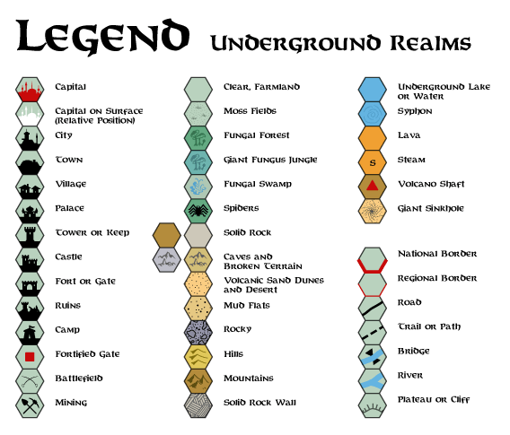
Into and out of the City
To start with, there is the pressing problem of getting into and
out of the City of the Stars itself. Skinwing flying is one obvious
possibility, but skinwings can carry virtually no cargo, so this
has limited usefulness (the army has most of them anyway). Magic is
a possibility ( being the obvious spells).
But there are still problems--what about 1st-level characters? What
about merchants with cargo to shift?
The problem is fortunately solved by the existence of what the
shadow elves call "gravity flutes," narrow cylinders of altered
gravity which exist at the sides of the Great Cavern near the City
of the Stars. Gravity flutes are not found more than 10 miles from
the City of the Stars. Shadow elves call them because they
are cylindrical in shape and because there seems to be a gentle,
almost inaudible sighing of an unfelt breeze within them. (Other
races do not hear this.)
A gravity flute is 5-30 feet wide. A shadow elf entering one can
at once recognize it by a rising of the hairs at the nape of his
neck (other races must make a Wisdom check to recognize gravity
change here unless they experiment).
When a gravity flute is entered, the wall becomes "down." One
simply steps off the floor (Great Cavern) on to the wall (which is
now the floor). When one reaches the ceiling of the Cavern (City of
the Stars), this is of course just another wall (while you are
inside the gravity flute), until you step out on to it, when it
becomes the floor.
It takes 1d20 rounds to find a gravity flute, or 2d20 rounds if
the seeker is more than 5 miles from the City, since they move
around slightly and are rarer the further one goes from the City.
Movement rate within the gravity flute is at normal speeds.
This explains how merchants get to the city on the roof of the cavern with their wares, as well as why the roads converge below the city - because you have to go to the area below the city to find a gravity flute.
- Karameikos from GAZ1
(New border) - Lower Broken Lands from GAZ10
(New border, title scroll; appears as a replica for the first time, although the changes are extremely minimal)
This post will self-destruct in one week.
Edit: Fixed the links. I hit preview halfway through writing by mistake, and it did something strange to the URLs that I didn't notice.
This post will self-destruct in one week.
lol. Unforntunately, the links don't work for me
.[EDIT] You can see the maps if you delete the last part of the address that looks like this " %5B/URL ". [/EDIT]
By the way, Thorf, I don't know if this was already discussed, but considering the Princess Ark and Red Steel maps' gap, which will be the destiny of the Keep of Vastrovek, Tower of Brugzol, Narvich and Bukovosko (between the City-States and Kladanovic)?
Well, so far I have ignored that part of the map completely. But perhaps we could rescue them... The terrain on the Red Steel map should obviously be completely ignored, but there's no reason to discard those settlements and their names completely. We might have to tweak their positions a bit, I'm not sure.
Actually though I had forgotten about them completely, until you brought them up now. :embarrass
Well, so far I have ignored that part of the map completely. But perhaps we could rescue them... The terrain on the Red Steel map should obviously be completely ignored, but there's no reason to discard those settlements and there names completely. We might have to tweak their positions a bit, I'm not sure.
At least with Keep of Vastrovek we might not have problems, it was placed very close to Kastr (in the other side of the "Yavdlom Outer Reaches" border). This seems to be the easiest one.
Narvich is definitely between Kastr and Kladanovic. Pehaps Bukovosko is close to the Throat River... And I have no idea about Tower of Brugzol... Pehaps in the Konumtali Savannah? By the way, I don't even know what inhabits this tower (pehaps hobgoblins?)

This one took quite a while - drawing in all those mountain contour lines. I'm glad that not too many maps have them! :embarrass
Incidentally, this is part of my continuing effort to finalise my updated Gazetteer series maps. Yes, that's right: it has finally come time for me to deal with the nightmare that is B10.
I made it a "Faerie Realm" sort of like Haven, except that it is never truly in Mystara, it is next to Mystara. Plarr removed it from Mystara and dropped it into the Spirit World shortly after the collapse of the Hutaakan Empire. The only way to access the Lost Valley is through the Gateway, at the end of the Firefoam Valley. It is a literal magical gateway that takes those who pass through it from Mystara to the "Lost Valley" in the Spirit World. In Mystara itself, the area of the Lost Valley is a series of tall mountain peaks and high valleys, cold and unwelcoming save for monsters and hermits. You could climb all over those peaks and never find any sign of the Hutaaka...
That's how such a big, honking valley can remain "lost" for so long...
Well, what with all the trouble the "Lost Valley" caused me in my workings with Karameikos, I decided to get rid of it... as in, remove it from Mystara.
I made it a "Faerie Realm" sort of like Haven, except that it is never truly in Mystara, it is next to Mystara. Plarr removed it from Mystara and dropped it into the Spirit World shortly after the collapse of the Hutaakan Empire. The only way to access the Lost Valley is through the Gateway, at the end of the Firefoam Valley. It is a literal magical gateway that takes those who pass through it from Mystara to the "Lost Valley" in the Spirit World. In Mystara itself, the area of the Lost Valley is a series of tall mountain peaks and high valleys, cold and unwelcoming save for monsters and hermits. You could climb all over those peaks and never find any sign of the Hutaaka...
That's how such a big, honking valley can remain "lost" for so long...
Interesting theory, though if you're going to put it in some other realm, why not use the Hollow World? Those who are able to find the path leading to the valley are actually transported into the Hollow World. Ofcourse, leaving the valley for other parts of the HW is so difficult it almost doesnt matter...
Håvard
I made it a "Faerie Realm" sort of like Haven, except that it is never truly in Mystara, it is next to Mystara. Plarr removed it from Mystara and dropped it into the Spirit World shortly after the collapse of the Hutaakan Empire. The only way to access the Lost Valley is through the Gateway, at the end of the Firefoam Valley. It is a literal magical gateway that takes those who pass through it from Mystara to the "Lost Valley" in the Spirit World. In Mystara itself, the area of the Lost Valley is a series of tall mountain peaks and high valleys, cold and unwelcoming save for monsters and hermits. You could climb all over those peaks and never find any sign of the Hutaaka...
That's how such a big, honking valley can remain "lost" for so long...
That's one solution, and not a bad idea. It certainly deals with the problem of having such a large valley lost in a world with flying carpets, flying monsters, flying ships, air cavalry, and so on.
There are other solutions, though. I think my favoured solution would be to explain the valley's lost nature with a combination of nigh-impassable mountains and covering enchantments and illusions. These could even be the work of an Immortal - perhaps Pflarr decided to hide the civilisation from the eyes of the world rather than move it completely from Mystara.
I like this solution because it leaves the valley accessible for those who know about it, without removing it from the world completely. There's definitely something to be said for having the valley exist in Karameikos - for me it adds a certain feeling of ancient history that I wouldn't get otherwise.
In any case, I am thinking of creating two final versions for the 8 mi per hex Karameikos map: one with the valley marked on, and one with it hidden from view. The Foamfire Valley of course will be marked on both.
There are other solutions, though. I think my favoured solution would be to explain the valley's lost nature with a combination of nigh-impassable mountains and covering enchantments and illusions. These could even be the work of an Immortal - perhaps Pflarr decided to hide the civilisation from the eyes of the world rather than move it completely from Mystara.
I tend to agree with this solution. I think that if Pflarr wanted to put away his surviving followers, he'd place them in the Hollow World rather than in another "faery realm". ;)
BTW, I'm looking forward to the Karameikos/B10 integrated map!
[*]Lower Broken Lands from GAZ10 Updated 6th May 2006
hey Thorf
just a little typo in this one
hey Thorf
just a little typo in this one
Thanks Shawn.
I fixed it.Regarding the B10 maps, preliminary work shows that the three hex maps in B10 do not line up properly with each other.
The size and shape of the Lost Valley are slightly different on each map.Also, the other two maps - Eastern Karameikos and the Foamfire Valley - were both done on rotated hexes. It's especially strange considering that the Lost Valley and Foamfire Valley maps are both the same scale and actually overlap each other.
In any case, the conflicting parts are not too serious, so I should be able to incorporate all the important features onto the Karameikos map.
In any case, the conflicting parts are not too serious, so I should be able to incorporate all the important features onto the Karameikos map.
I'm really looking forward to this one!
Had any thoughts on a TR map yet btw?
Håvard
I'm really looking forward to this one!
Had any thoughts on a TR map yet btw?
Your one was so good, I don't know that I need to do one. ;)
I'll probably do a hex version eventually, but I'm afraid it's an extremely low priority for me. I don't have all the Thunder Rift products, even as PDFs, and I have never been able to get hold of the actual Thunder Rift accessory. (Hence my conspicuous lack of replies in your project.)
But eventually I will get round to buying (and reading) the PDF version.

I will finish drawing in those pesky but nice-looking lines on the mountains at a later date.
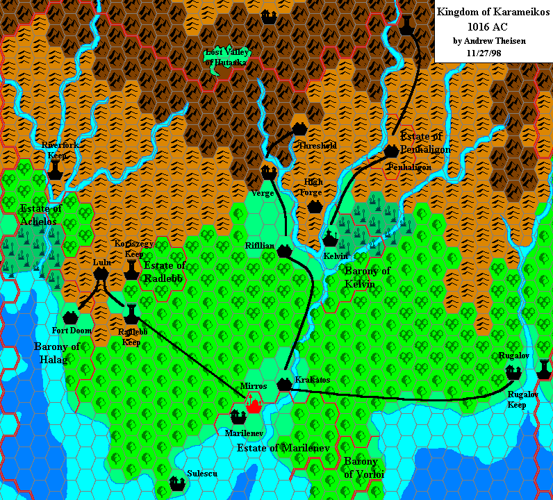
The Foamfire Valley itself is a big deal, but I personally prefer a map more like the one in B10, which, IMO fits better with the description and information of the Threshold region from the Expert set than the location of Threshold on the Gaz map- though I think we've had this discussion before.
FWIW, I came up with this version of a map to try and solve the various problems of scale and general different mappiness of the B10 and Gaz maps.
Yep, in fact your map was the first I knew of the B10 maps. I still don't have the module myself.
The Foamfire Valley itself is a big deal, but I personally prefer a map more like the one in B10, which, IMO fits better with the description and information of the Threshold region from the Expert set than the location of Threshold on the Gaz map- though I think we've had this discussion before.
I agree. The most significant point is that B10 is not alone in its portrayal of Threshold and the Foamfire Valley, but in fact it was a direct follow-on from the Expert Set maps. Add to this the map of Threshold, which remained unchanged from the 1981 Expert Set all the way through to 1994's Karameikos: Kingdom of Adventure, despite the seemingly-obvious problems with Threshold's position on a river flowing out of a lake...
Add to this our treatment of Kelvin earlier in this thread, where we moved it so that its city map would make more sense, and there is a very good case for reinterpreting the position of Threshold, and adding in the valley.
The only problem then becomes how far to move it, where to put Verge, and so on.
I assume that you know of the B10 maps on Thib's site?
Regards
Gary
Thorf
I assume that you know of the B10 maps on Thib's site?
Yes, but thanks for reminding me Gary.
Does anyone know where those maps came from? They were done using Campaign Cartographer. It would be very nice if I could get copies of the original files - especially copies that I could import into Illustrator.I do have a PDF of B10 by the way, so I have copies of the original maps to trace. But I have yet to get round to reading through it.
Thorf my game is in the year 1006AC right now, and an 8mile hex map of the crater region would be awsome. But I know your still recreating the old existing maps (like B10) right now, but do you think you might end up doing a map of the crater? :D
It shouldn't be a problem. I'll move it to the top of my list.
Correct me if I'm wrong, but I believe the only sources for the crater are Wrath of the Immortals and Glantri: Kingdom of Magic, right? It may have been in an Almanac too. And of course Andrew did a very nice map of the crater a few years ago.
My map will be based on those sources, and likely very similar to Andrew's. Let me know if there are any other sources I missed.
Are there still plans for an 8 mile/hex map of the Heldann region?
Cheers,
LJ.
WOW.
Thank you so much for all the hard work you have put into digitizing all the maps you can find. That's absolutely amazing. I was bemoaning my parents for chucking out all my old D&D stuff (including TM1, TM2 and the gold Immortal box set), but having such an excellent set of maps available online is a great resource. Kudos and keep up the good work!
Thanks,
Gary
My mapping files are released under a Creative Commons license, which basically allows anyone to use them as long as they give me proper credit. For more information, check the link on my site.
I wonder if and how these features could fit on the map of Karameikos:
-Any official placements of adventures marked with a bullet point like is done on the black & white Expert set map.
-The official boundaries of the Gnome-Kingdom of Highforge
-The official boundaries of the Elven-kingdoms within Karameikos
-Reconciled locations from AC2 adventure "Treasure of the Hideous One"
-Details from DUNGEON magazine adventures. For example, the area along the Westron Road from issue #24
-Reconciled locations from the novels.
-At least on the vicinity map of Threshold (the one based on B10), including symbols for the Caves of Chaos and Caldwell's Castle to the west of town, and Castle Mistamere north of town - maybe at the end of the road.
-For that matter, I wonder how many other of the adventure locales, such as Stefan's hunting palace from Skarda's Mirror, or the Sukisyn homestead from B10, can or should fit on the 8-mile hex map, and what symbols would be appropriate.
Shane
I wonder if and how these features could fit on the map of Karameikos:
We (i.e. LoZompatore, Havard, and me) had already suggested some enhancements to Karameikos' map on page 19 of this thread. However, I think it would be rather difficult to add all of them without increasing the scale of the whole map (perhaps drawing some zones in the '1 hex = 1 mile' scale - that would be the point with Threshold area).
One more question about Threshold area: what are the right sizes of Windrush Lake (the lake of Threshold)? According to the non-hex map included in the adventure booklet of KKoA, the lake seems as large as an 8-mile hex!
Could it be represented in the '8-miles per hex' map of Karameikos?Second - after the praise
- is there any chance we could get a single HUGE map merging together all the 8 mile hex maps - at least those of eastern Brun (something like TM1+TM2)? The problem with 1 nation = 1 map is that whenever you want to play stuff that's happening over a border (say, a war!), hopping from one map to the other and back is a somewhat frustrating experience.I haven't seen Thorf around in a while (probably busy with RL. Doesn't he know that Mystara takes precedence over everything else? ;) ), but I found some map issues the other day and thought I'd see what everyone else's thoughts were. (I seem to recall there was a Map Problems thread separate from this one, but danged if I can find it.)
Anyway, the main issue is Ierendi Island. Gaz4 mentions that Port Siers was destroyed when Mount Haumea erupted, but the Trail Map has Mount Makalaui right next to Port Siers. Given that none of the volcanoes were named on the Gaz4 map, and the later description in Gaz4 of the Makalaui Crater, I think that Mt. Haumea should actually be the name of the volcano near Port Siers, and that Mt. Makalaui should really be the volcano currently named Mt. Kununuroa. (In which case, there is no such volcano as Mt. Kununuroa- again, these were all named after the fact, as they have no names on the map, and only in the text.)
Alternatively, I suppose we could just assume that Mt. Haumea is another volcano located near to Mt. Makalaui, but not visible on the 8 mile hex map (but on a larger scale map it would be).
In any case, I note that Thorf's Ierendi map is missing the volcano hex for Mt. Makalaui near Port Siers.
Also, Thorf, on the Thyatis map, you have Halathius in northern Thyatis marked as a Duchy, when it is actually a County.
Where did the Fort Marny appear to that map?
Another thing is why you have seen it necessary create a separate marker for the fen in Fenhold. Why wans't the swamp or bog feasible in this case?
Where did the Fort Marny appear to that map?
This comes from GAZ14 Atruaghin Clans. They needed a fort in that part of Darokin due to the aggresivenessof the Tiger Clan just over the border.
Atlas of Mystara
Please come and join me and many of the other contributors to this thread as we discuss this mammoth new undertaking.