
Alphatian Undersea
by Hausman SantosI was that days joining the suggestions of all (thank you for the collaborations) and I tried to do a fast map of Alphatian Trench area between Aquas and Sundsvall Maelstrom (southeast Alphatia) in a scale of 24m / hex.
To do this map I used as reference the map WotI (1010) and the map PWA3(1012 - Alphatian sea).. both are in a scale of 72miles / hex... then I caught the map of Alphatia (DotE) and I checked the area that formed the islands and I made a zoom. I noticed some important things that should consider in the map:
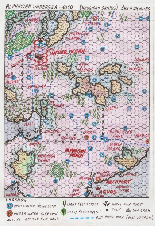
Alphatian Trench: in agreement with PWA1010-1012 (atlas Aquas: notable sites) this to a mile to the Aquas north (I put some few miles)and it's seen as the largest trench of every Mystara... to a length and wide that shelters everything that once day was the Alphatia continent (including the ruins of the cities). so I did include the old borders of the continent inside of the trench.
Colonies of Aquas: in agreement with PWA1010, Aquas began explorations for colonisation to the north of Seashield (Archport was the most logical point), like this, I include on the close ruins of Aquas, some of the native of Seashield to represent that expansion and exploration attempt (mermen, triton, sea giant, nixies...).
Naval Ruin Ports and Undead: the port cities that had ships would have formed this cemetery of ships (with treasures in the place and died) forming a style as lost treasures and ghosts of the sea.
Behemoth's Cave: as seen in PWA1010 the team of exploration found the cave near the northern of Aquas (that makes to believe me that it would be in the Alphatian trench) and they still saw him leaving the cave for they haul sea. I put it in secure one distance holds of Aquas, but it could be in another place also close of Aquas to the north.
Golems Around Fort Lines: I like the golems idea that Khuzd spoke, I believe that in the period of the war many golems also had been mobilised for military places to facilitate heavy services, to provide materials or local, auxiliary in the load of things, like this the forts and military posts would be a good option of them in the map. it would be interesting the idea of you see them ties providing the military bases against intruders today.
Wyrds Northwest Sundsvall Maelstrom: in this point, it begins the ruins of the old kingdom of Shiye-Lawr, in this place, some banshee and wyrds would be logical option.
Underocean Borderlines: In agreement with Underocean Timeline, the capital of the tritons would be to 100 miles to the north of the maelstrom (with communities to the west, east and south of the maelstrom) the line of the borders would be a suggestion in agreement with the geographical description (I still didn't read any description of the atlas of Underocean). The creation of the kingdom dates in 1010, then I include it on the map.
Devilfish south of Underocean: Devilfish are mentioned in the Underocean timeline in what will generate a war against the tritons of Underocean (it also mentions the city of Aquatic Beholders, but the city was not included in the map due to his geographical location: somewhere between the island of Aasla and Monster Island). even after the war (with the departure of the devilfish), some devilfish could have stayed in the ruins to the north of Mt. Thera.
Velya & Blackheart liches: It includes in the map some velya between the islands of Aasla and Arogansa (thank you Hĺvard for the suggestion). I left the Blackheart liches (suggestion of GP, thank you) for a work more elaborated in Blackheart (future map).