
Arcania project
by PeetMy original discovery of the "Known World" was back in the early 1980s when I got the original Expert set and module X1. I was immediately enchanted by the map of the Known World and its descriptions of the lands therein (I actually didn't know it was called "Mystara" until recently). It was immediately obvious to me that this would be a great "natural" world for a D&D adventure. The mapping system was easy to duplicate, and the world had a certain logic to it that was appealing. The various nations had reasons for existing and relationships existed between them that could provide the basis for adventures. I certainly believe that the Known World is superior in conceptualization to Faerun, and far better than Greyhawk. It wasn't until Krynn that TSR got its head together and created a product that had more to offer in it, but consider the vast amount of resources poured into the Dragonlance line and you will see that it was inevitable that Krynn would be something great. And yet... Krynn was a specialized world, with very specific themes dealing with the aftermath of catastrophe and the loss and regaining of hope and faith. It made for a great campaign, but if you wanted a more generic campaign without those themes, you needed something more generic. So the Known World still stood forth as a decent place to put your campaign.
I was aware of the subsequent material published for the setting but as a kid I never had a lot of money for gaming. Then I and D&D parted ways back in the late eighties as I switched to other games. So X1 sat on my shelf until I recently dusted it off and looked at it again.
While I always appreciated it, there seemed to me to be a few problems with the world, and I figured it might be fun to re-do things a bit.
Now I know that some of you guys have put a huge amount of work into the world of Mystara as it is, and what I am doing here probably won't be compatible at all with what you guys have. But nevertheless I figured I would share on the off-chance that people might be interested.
-----
So here are the things I am addressing with this project:
1. Scale
The original map from X1 shows a variety of nations in what looks like a wide variety of climates. It looks like you have a cold north and a hot south. But actually the scale of the map makes it not a very large region. Either the world of Mystara is much smaller than Earth or the entire map is set in the warm temperate and subtropical regions.
I think that the original intent of the map was that the map would stretch from the subarctic to the tropics. The Heldann Freeholds are described as being "like Iceland" and I think it was envisioned that they were at a similar latitude as Iceland as well. With the bottom of the map having jungles on it (such as the Isle of Dread) that would constitute a wide range of climates.
Now I know that there have since been a bunch of things published about lands off the original map, like Norwold and Wendar, which extend the continent up into the far north. I think that someone at TSR realized that there was a scale problem, and rather than trying to make a correction they just rolled with it and added more land. But I think this diminishes the flavour of the original map.
My solution is to change the scale of the original X1 map from 24 miles per hex to 60 miles per hex. The map is 72 hexes high which makes the total distance 4320 miles. I envision the top of the map to be at around 55 degrees north latitude and the bottom of the map to be approximately the equator. That distance on Earth would be about 3950 miles so we're in the right ballpark - this would make Mystara slightly larger than Earth, or I could shave off a bit and say the Equator runs through the Isle of Dread instead of being to the south of it.
2. "Scandanavia"
The coastline of Vestland and the Soderfjord Jarldoms seems to be drawn with Norway as an inspiration, with the coastline littered with fjords; one town is even called "Soderfjord." But a fjord is created when a glacier digs out a trench as it descends from the mountains into the sea. When the glaciers melt a mountain valley called a fjord is left behind. But in Vestland and Soderfjord, the mountains are far away and the coast is adjacent to a broad plain. This means that the inlets along the coast are not fjords at all; they are simply bays.
In order to preserve the Norwegian "flavour" of these regions I decided to have the mountains stretch all the way to the coast, making these inlets into actual fjords.
Doing this also resolves one other geographic anomaly, which is the altitude of the Ethengar Khanate. The altitude of the coastline is all the same; that is, sea level. But if you go inland up a river, every point on that river will be uphill, a higher elevation than anywhere downstream, because water flows downhill. If you follow the Streel River up into the Khanate (follow the easternmost branch), you will see that the source of the Streel is only one hex away from the coast in northern Vestland. In order for that to be the case, not only does the land need to plunge downward sharply over that hex to return to sea level elevation, but it has to do so in a way to prevent the Streel from just flowing down the nearby hills and to the coast one mile away. Putting a range of mountains along the coast would accomplish this.
3. The "Empire" of Thyatis
Thyatis is described along the lines of an imperialistic state along the Roman model. And yet, Thyatis has no real natural enemies on the map. While they may need to guard their northern border against raiders from Ylaruam (a region which would never be worth conquering by the Thyatians because it is a desert), they otherwise have little need of a standing army and seem to lack the aggressiveness that kind of state ought to have.
Now I know that once the world was expanded the Thyatian Empire was spread overseas to include huge areas (relatively speaking) on the Isle of Dawn and elsewhere, but if Thyatis was capable of conquering those huge areas why does it have so little territory on the mainland? They even gave away their westernmost province to one of their dukes who wanted to go on an ego trip. If Thyatis could conquer half the Isle of Dawn they surely could have taken Minrothad and Ierendi, and perhaps marched past the Malpheggi swamp to take Darokin.
Thyatis is also described as having a strategic location along a "canal" (though it looks like a natural waterway to me) but on the map from X1 if you wanted to avoid Thyatis you could simply spend a couple of extra days going around the cape by boat. I wanted to increase the "strategic value" of Thyatis' location.
Since I do like the idea of the Empire of Thyatis and wanted that Idea to work better, I decided to give Thyatis some more natural enemies, and put the extra land needed to create it at the end of the big Island south of Thyatis (which is unnamed on the map). This basically forms the western end of a new continent, making the Thyatis passage the only way to travel from eastern sea to southern.
4. Ylaruam
The Emirate of Ylaruam is another region that I like the concept of. It isn't especially original but its basis on Earth cultures makes it easy to populate with details.
Yet it bugs me that the Arabs live right next to the Vikings.
Culturally this seems like a very bizarre clash. Climate-wise this seems kind of strange too. While the Emirate is placed within a clear rain shadow caused by mountain ranges, this creates some additional problems. If the prevailing winds are from the west or south the Ylaruam will indeed get little rainfall, but then neither will Soderfjord or Vestland. If the winds come from the north then Soderfjord and Vestland get rain but then Thyatis should also be desert. It seems unlikely that Ylaruam would be the only arid country in a region surrounded by moist ones.
The easiest thing to do was to move Ylaruam. Since I was already creating a new Eastern continent I decided to move Ylaruam there. The region where Ylaruam was would have to be populated with more European-like nations. This also helps the issues with Thyatis (above).
5. The Lands of Chaos
Though there's no actual campaign world introduced in the original basic set, the "Background" section in module B2 Keep on the Borderlands has this to say about the world:
The realm of mankind is narrow and constricted. Always the forces of Chaos press upon its borders, seeking to enslave its populace, rape its riches, and steal its treasures. If it were not for a stout few, many in the Realm would indeed fall prey to the evil which surrounds them. Yet, there are always certain exceptional and brave members of humanity, as well as similar individuals among its allies - dwarves, elves, and halflings - who rise above the common level and join battle to stave off the darkness which would otherwise overwhelm the land.
This is a really great intro and after seeing it you want to jump right in and battle some orcs. It's a great "feel" for a campaign world.
But in order for that to work there have to be significant areas of the map that are held by the forces of chaos. This doesn't really seem to be the case; humans "and their allies" have filled up all available space, leaving only the broken lands as a home for orcs, goblins, trolls and whatever else, since it seems like the Broken lands aren't actually worth anything.
Where is Mordor? Where are the dark empires or barbaric lands full of monsters threatening to overwhelm civilization? There don't seem to be any. Human civilization seems pretty well secure.
I decided that the territories of chaotic creatures needed to be expanded to pose a genuine threat to civilized folk. Of course, in the case of barbarous monster-infested regions, there is no reason why a Lawful nation would need to recognize its sovreignty and large areas of monster infested areas might be claimed by civilized lands even if they don't police them (much like Karameikos). But there needs to be a lot more "room" for chaotic creatures.
-----
Okay, so those are my goals. I've downloaded Hexographer and I've started working on a new map. This version of Mystara I'm calling "Arcania" as a way of distinguishing it. I'm happy to post it here if people are interested.
Right now I am learning to use Hexographer and am starting to get the hang of it. I am still trying to figure out how to make a coastal hex that is half water and half land; I have drawn the coastline of the mainland but when I try to put stuff in the hex it shows on both sides of the coast. Am I supposed to use the line function to draw in more ocean?
So far this is what I've got for the area where Ylaruam used to be. I'm liking the way the coastline turned out. I still have some islands to do and the coastal terrain issue needs to be finished when I figure out how to do that.
I am aware that the original X1 map was never meant to be a "world map." How could it when land trails off two edges? But I do think that the original map was meant to stretch from Equator to near Arctic and the designer didn't check his scale - he just assigned an arbitrary number which seemed reasonable for play scale but turned out to be less than half of the comparable area on Earth. So if you are using my adjusted map scale then the "known world" takes up a much much larger part of the continent of Brun. So there is no Wendar or Norwold in Arcania because the Known World map now covers up those areas.
I do know about the other continents Davania and Skothar though that is probably beyond the scope of what I am doing here. I am likewise not using Alphatia or the Isle of Dawn. In particular I am only drawing on the original map for geographic resources. In my mind the Isle of Dawn and Alphatia were created because of the problem with Thyatis that I listed in my original post - they existed to make Thyatis into a genuine "Empire" and to give Thyatis an enemy to fight. I honestly haven't read anything about those areas and if I do read things I like about them I may steal them. But right now I am just not worrying about them. I have enough to do already.
I know about the whole Hollow World thing too and it is a neat idea, but I don't really know anything about the hollow world aspect aside from the fact that the inner world seems pretty savage... which is par for the course since the clear inspiration for the Hollow World is Edgar Rice Borroughs' Pellucidar series, and Pellucidar was quite primitive. No reason to say that Arcania is not also hollow but that's another thing I'm not going to worry about.
Maybe Mystara doesn't have such a good and evil focus, and I am totally for settings with moral shades of grey and imperfect cultures. But the background passage from B2 was really compelling and I do like the idea of the "precarious security" that it suggests. The idea that the heroes might be forced to save the world even though most of the world does not exactly deserve saving is a decent basis for a story. So I am ramping up the power of the chaotic demi-humans and their evil human allies.
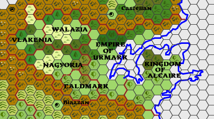
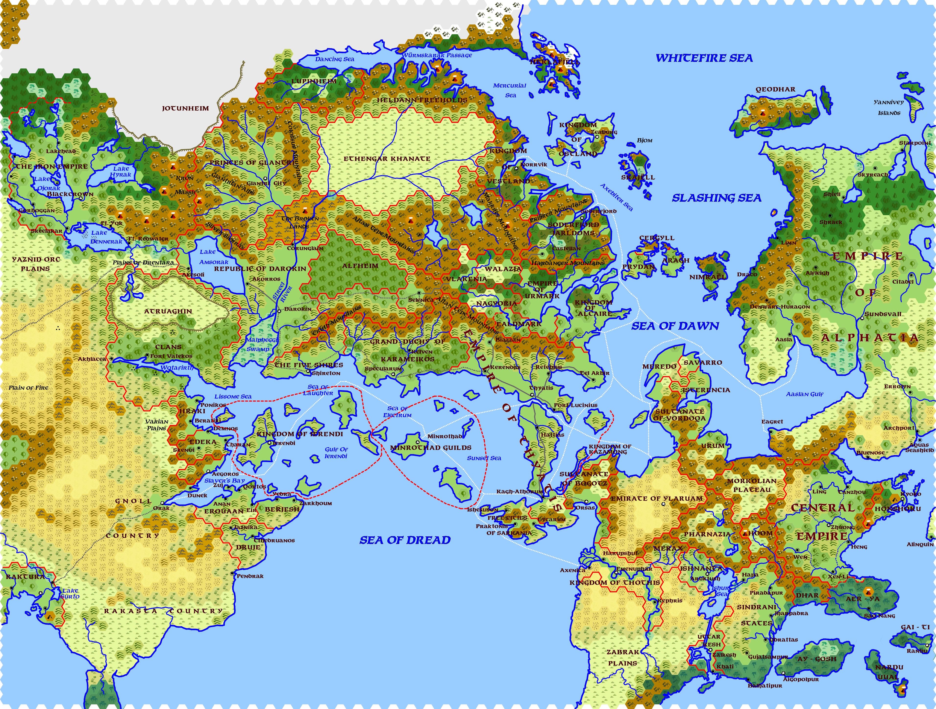
As far as basic GazF info on the countries on the map above, here are some details:
Regional info: The region is divided culturally into two regions, east and west.
The inhabitants of the Eastern part are related to the "northmen" and their original settlement area was the area around Castellan. They spilt into two groups, one migrating northward and forming the "northmen" cultures, while the other group moved south (who became collectively known as the Koromani) into modern-day Urmark. As they moved south they came into contact with the northern fringes of the Empire of Thyatis, which at the time controlled Alcaire, Ealdmark, Nagyoria, and southern Urmark. Thyatis had conquered the primitive Gadali and Cemiri people who lived in those regions. The Koromani gradially exerted pressure on Thyatis as their population grew, and frequently the Thyatians would bribe one tribe of Koromani to fight the others. Eventually during a period of Thyatian corruption and dissolution the Koromani entered the empire and took over Alcaire, Urmark, and Ealdmark. Many Koromani settled in the Northern reaches of Thyatis and some even tried to attack the capital, though none were ever successful.
Kingdom of Alcaire - (based on medieval France) Alcaire is the most "civilized" nation in the region, and is united under a fairly strong King, though many powerful vassal nobles rule the various parts of the kingdom. Alcaire adopted many of the traditions and institutions of the Thyatians, whose remnants made up the literate class in early Alcaire. Alcaire is a powerful and growing nation and many believe that its star may eclipse that of Thyatis soon.
Empire of Urmark - (based on medieval Germany) Urmark is a collection of petty Kingdoms, Duchies, and Counties who are technically united under an emperor who leads the nation when exposed to external threats, but practically speaking the Emperor of Urmark has little actual power beyond his immediate domains, and the lords of the various estates mostly do as they please. Because most of Urmark was never a part of the Empire of Thyatis, the literate influence that partly defined Alcaire was never felt here. Urmark is seen as more primitive than Alcaire, though this is most notable in the areas of Law and the Arts, in which Urmark seems much less refined. Technologically the Urmarkers are at no disadvantage against the Alcairi.
Ealdmark - (based on medieval Austria) While the people of Ealdmark are largely of the same stock as those of Urmark, they have a much more artistic bent thanks to their Thyatian influence and the nation is known for its music and architecture. This is not to say that the Ealdmarkers are effete - they have often been ravaged by the Ethengari and Nagyori, never mind having to wage war periodcially against various lords of Urmark. While technically Ealdmark is a part of the Empire of Urmark, Ealdmark is a large enough domain that the Emperor has little sway there, and recently Ealdmark has become allies with Nagyoria; the two royal lines have intermarried. With Nagyoria as a staunch ally the nation of Ealdmark can afford to ignore the Empire of Urmark when it suits it.
------
The western half of the region is dominated by the influence of the Ethengar Khanate. Periodically, people from the Ethengar Khanate would move down the pass through Rockhome, and while the dwarves of Rockhome often trade with the Ethengari and charge a toll for travel through the pass, when large armies came south they would simply shut their gates and let the Ethengari pass by, knowing that they had no skill at siegecraft and posed no threat to the dwarves. While not as large as Ethengar, the lands of Walazia and Nagyoria possessed decent grazing lands for the herds of the Ethengari and made a decent "headquarters" for the Ethengari while in the region. The Ethengari periodically raided Thyatis and other regions in the area. Other Ethengari went west through the pass to the Selenical region, and a few even went through the passes in the Cruth mountains into Karameikos. The inhabitants of this region are considered to be ignorant and superstitious by Easterners, but then there are plenty of wild areas where many dark things could lurk.
Nagyoria - (based on medieval Hungary) Nagyoria was the primary headuarters of Ethengari groups and as a result the Nagyorians have significant Ethengari blood. The times when Ethengari chiefs used Nagyoria as a base and threatened Thyatis are remembered fondly and many Nagyorian children are given the names of the great Ethengari Warlords of legend when they are born. Nevertheless, despite a strong cavalry tradition Nagyoria is an agricultural region like any other in the region, but the Nagyori do not reject the brutal and the savage the way other nations do. The nations of the East look down on the Nagyori a brutish and ignorant people, but they still fear the Nagyori cavalry.
Walazia - (based on medieval Poland) Walazia is another region that was frequently dominated by the Ethengari, though the Ethengari rarely used Walazia as their central "base," preferring Nagyoria for that. As a tributary nation to the Ethengari the Walazians were often oath-bound to their overlords, and the Walazians value honor very highly. They traditionally refuse to break their vows, even when it is in their interest to do so, and many other nations consider the Walazians to be stupid for the lengths they seem willing to go to fulfil their oaths. Much of the history of Walazia contains stories of how various Walazians were trapped or tricked into making oaths which were not in their interest. Walazia is often under pressure from Urmark, and many Urmarker nobles see the invasion of Walazia as a good way of expanding their domains; some of the Eastern reaches of Walazia are dominated by Urmark. Like the Nagyori, the Walazians are seen by easterners as ignorant and superstitious, but Walazians are much more open and willing to deal with outsiders.
Vlakenia - (based on medieval Transylvania) Vlakenia was often a region where Ethengari armies passed through on their way south from the passes of Rockhome, and the people of Vlakenia sometimes submitted to the invasions sullenly, and at other times resisted fiercely. The rugged nature of Vlakenia helped them in this regard, though they were often defeated by the superior numbers of Ethengari. Vlakenian leaders have a reputation for brutality, a price the Vlakenians have paid to have lords capable of leading them against the mighty hordes of Ethengar. But even this was not always enough, and it is said that many Vlakenians made pacts with dark forces for aid against the Ethengari. While a Vlakenian village may seem like any other during the daytime, at night the Vlakenians bar their doors securely and do not travel outside after dark. They tell travelers tales of Werewolves, Vampires, and other fell creatures that roam the lands at night, and implore such visitors not to go out after dark.
OK, here's another image.
This one shows the area covered by the original X1 map in red, and for comparison the approximate area of the Arcania map in light blue.
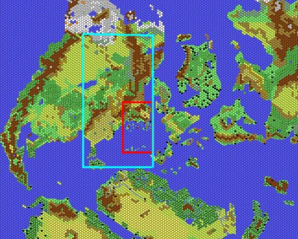
As you can see the area is much more significant.
I think I want to retain the overall shape of Brun so I might add a large land mass south of the Atruaghin clans that connects to the main continent off the map to the West since that region (the Sind desert?) would now show up on the map otherwise and this would distort the shape of the continent if I left it out. I don't want it to get too close to the Thanegioth Archipelago though so I may crop that little peninsula (Serpent Peninsula?) or move it further west.
Actually now that I look at it I may have to shuffle the Arcania map a bit to the east to avoid the Serpent Peninsula and leave more room for that the Sind desert area. Though if I use Sind I plan to move it off of Brun and to the East somewhere.
Here's another one... it's ugly and muddy but it illustrates the point.
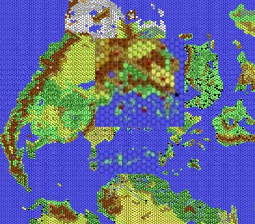
I pushed the area east a bit so as to leave some room for the Sind Desert, which some of the Arcania map will have to be edited to include. I may turn much of the Sind Desert area into savannah and make it a home for the Rakasta. The eastern coast is pushed out and overlaps with the Isle of Dawn, which I am redoing anyway (sort of). The Thanegioth Archipelago now goes right from the Serpent Peninsula to Ochalea(?) so I might move it a bit to fit those in.
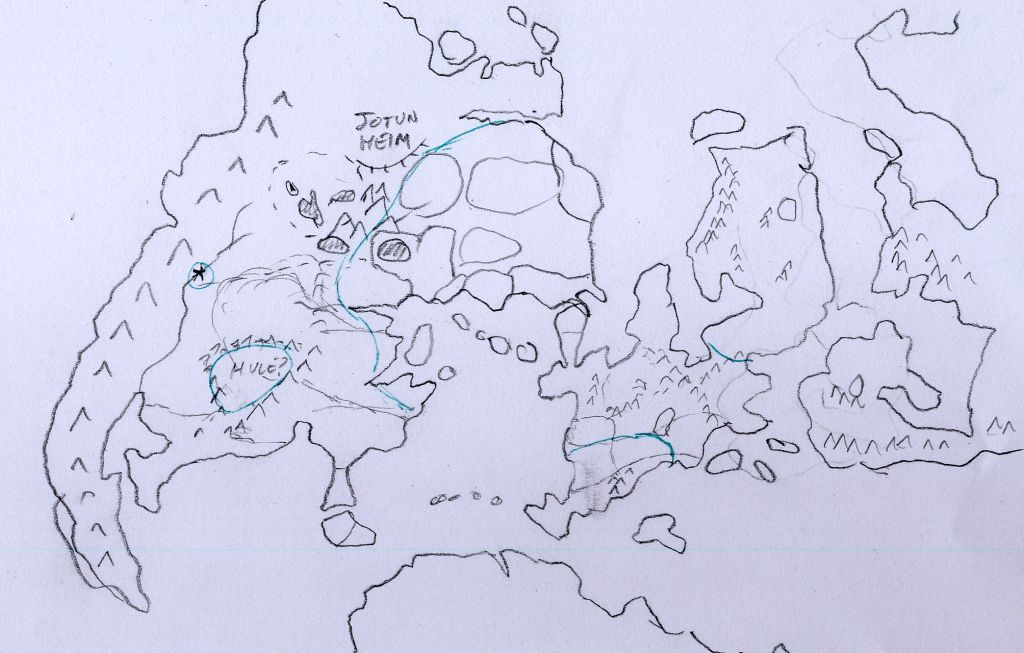
OK, here's a quick rundown on the increased chaotic forces at work in the known world area.
I don't think this disagrees with Canon that much.
Jotunheim - exactly what it sounds like, a land of giants. Since it's in the far north it's mostly frost giants with a smattering of other types. Also white dragons, lots of trolls, and any chaotic demi-humans that like the cold. The wizards of Glantri periodically have to fight them off, and arrogantly assume that they will always be able to do so, though sometimes they only manage to turn back the hordes by the skin of their teeth.
Western Incursions - off the western edge of the map I am envisioning two major chaotic groups that threaten the known world. One will be a savage horde of barbaric people, probably with lots of orcs, which seeks to simply plunder and destroy. The other will be an organized and oppressive state often known as the "Iron Empire" that seeks to enslave and conquer. Part of my idea is that the Atruaghin Clans were once much more civilized but retreated into barbarism in order to survive the attacks of these cultures, fading into the hills and forests and only fighting by ambush. The Republic of Darokin constantly has to be on the lookout on this front also. Slavers from the Iron Empire are always looking for more slaves, and they may trade with some of the southern nations that have the institution of slavery.
I haven't decided if Hule will exist and if it will be off this edge of the map or not. From the descriptions in X5, Hule didn't really sound that scary. If I do use Hule I think I'll have to jazz it up a bit.
Central Barrier - it seems to me that the arm of the Altan Tepe mountains that runs north of Alfheim ought to be overrun with orcs and other demi-humans of the same groups that inhabit the broken lands; not only are these areas adjacent but it seems like Darokin (who supposedly owns them) has no ability to actually enforce anything up there. The demi-humans probably avoid the Khanate as once they get out in the open they will likely get ridden down, but in the hills and mountains they have some cover.
At the south end of this range I envision a fallen dwarven city of Rockhome that is now inhabited by chaotic demi-humans.
Kobold Kingdom - centred around the volcano in the middle here is a kingdom of kobolds. Though they are small they are organized and numerous and therefore they are a greater threat than might seem at first. Another fallen city of Rockhome would be the capital of the Kobold land, and there may be dragons of various types ruling the kobolds.
Southern Wilds - the area in the upper Duchy is pretty wild, as are the Cruth mountains. I don't think this differs much from canon. The elves of Alfheim keep the trail to Selenica clear but beyond the trail all sorts of critters seem to have the run of the place. The positioning of the Keep on the Borderlands so fr into the mountains seems kind of strange to me as the keep is not really "defending" anything so far up the river as it is basically completely surrounded by hostiles. Is this Basic D&D's Den Bien Phu? I would be inclined to move the keep downriver towards the more forested areas, which also matches the terrain around the keep in the original module.
At this point I've basically decided to put a limit on the range of Human civilization on Arcania. Essentially the "Known World" will be the Known World because it is the range of the human race. The areas to the West of the map will not be inhabited by humans (with the possible exception of Hule) and Brun will mostly be the home of various goblinoid races.
The subcontinent (which occupies the same basic area as the Isle of Dawn but is way too big to just be called an Island) will be dominated by humans, but lands to the East such as Alphatia and Belissaria may or may not... probably not. If I do use Alphatia in Arcania I think I will emphasize that they are a non-human race; though similar to humans they will be noticeably different. On Skothar anything will go - no humans there at all.
The northern coast of Davania as well as the tropical ends of Brun and the subcontinent will be dominated by conventional Lizard-Men. The jungle inhabitants will be pretty primitive but in the interior of Davania in the warm temperate region there may be some more advanced Lizard-man cultures.
The area north of the Serpent Peninsula will be savannah and will be inhabited by nomadic Rakasta. There may be some concentrations of more "civilized" Rakasta here and there, as described in "Rage of the Rakasta," but the canon description has them as nomads. I can envision a Japanese-inspired culture that is also nomadic, so that's what they will be like.
There may be isolated pockets of humans here and there but overall once you get out of "human territory" you won't see them any more.
OK, I did up a sketch map of the area around the known world. It's ugly but it gets the point across as to what I'm trying to do.
Thyatis is roughly in the middle of the map. The nations of the known world are mostly marked out with vague borders.
As you can see the Isle of Dawn has been substantially increased in size in the lower portion, which has been widened. Ochalea and Alphatia have been connected via land bridges. I did this by increasing the distance between Skothar and Brun a bit to make room. I suppose I need to come up with a new name for the land mass that comprises the former Isle of Dawn, Alphatia, and Ochalea. It's pretty much a subcontinent at this point.
Ylaruam will be on this land mass on a plain adjacent to the bay between the two peninsulas on the northern part of the Isle of Dawn section (not the Alphatia part). This part of the land mass is quite dry, naturally. The Thothians will be there too, though on the west side of the Isle instead of the east side. Since Ochalea ought to be tropical jungle considering the latitude, I moved the Ochalean culture to the area where the Thothians originally were. The Sind are on the other side of the mountains to the west. I hate having nations based on India and China being so small compared to their Earth counterparts, but I didn't see a lot of choice there, and I doubt most campaigns would remain in those lands for long.
You will note the green lines surrounding the known world area and the lower part of the subcontinent. There's also a green line around Hule and a little city in western Brun. This is the extent of human habitation in Arcania. Everyone beyond this will be demi-humans of some sort. Many will be savage, though some will be enlightened and civilized. Depends on where you are. Davania will be the primary home of the various reptilian races, though some have come north. Skothar will likely be the home of a variety of insect races like the Thri-Kreen, though Skothar's a big place and they won't be the only ones there.
I'm still not entirely decided as to what I'm doing with Alphatia. It would be a shame to throw away all that material but I don't think I can use the material straight. First of all, I have more of a "natural" history in mind for Thyatis, with the current Empire of Thyatis being only a shadow of its former glory. In Arcania The Thyatian empire once ruled all the southern coast all the way to Darokin and all the islands of Ierendi and Minrothad, along with a sizable chunk of the subcontinent. In the description in X1 it is described as being similar to the Byzantine Empire, so that fits more with the description.
My idea is that since the Alphatians are actually from another world they won't be entirely human, though like Elves and Dwarves they appear similar to humans. Since they have an affinity for air and the sphere of thought I am imagining them to be much like the Slyphs in Pathfinder and they have used their magic to dominate the indigenous races of the region. The pale-skinned and copper-skinned Alphatians may actually be different subspecies.
Here's the southwestern part of the map:
I haven't filled in any of the land areas here but west of Ierendi there sill be free cities along the coast and mostly desert inland.
Here's the southeast:
You can see the new position of the Emirate of Ylaruam now.
All right, I filled in the details on the land side of the southwest map.
Figured out how to do shapes to fill in the coastline and managed to figure out the scale of Alphatia relative to my rendering of Brun.

The West:
The Iron Empire
This region is an oppressive state run by hobgoblins, with Thouls among the ruling class. Also there are Fire Giants but their numbers are relatively small. The Iron Empire is so known because of their intense production of iron goods; iron is mined in the hills near Lakehead and shipped down to Blackcrown, where coal is mined in the hills nearby. Goblins make up much of the lower class, and humans are kept as slaves. Periodically the Iron Empire raids the Republic of Darokin for slaves and in the long run they hope to conquer the Republic.
Yaznid Orc Steppes
This region is controlled by wandering tribes of nomadic orcs. Mounted on horseback as well as on the backs of other animals, the Yaznids often raid the Republic of Darokin, but they generally prefer to sell their captives to the Iron Empire. However, they sometimes attack the Empire as well, and also raid the Atruaghin clans to the east.
Eastern Deserts
Though sparsely inhabited the Eastern deserts are homes to tribes of nomadic orcs, gnolls, and Ssisthik (sp?). A caravan route runs from Akesoli through the desert, and ends at the "Golden City" (off the map) - a city so named not because it is made of gold but rather that it is rules by a council of Gold Dragons. Though the desert is inhabited by hostiles the passage is safer than going through the much more numerous Yaznid Orcs to the north.
Orak
The city of Orak was once a human city but was overrun by gnolls centuries ago. Since then the gnolls have repulsed several human attempts to retake the city. Much of the city is still populated by human slaves who perform most of the menial work. The city is defended by one of several nomadic tribes of gnolls that live in the area. By ancient custom they may "camp" at the city for only so long and must spend the rest of their time in the desert; this prevents the gnoll tribes from getting "soft" with civilized living. The gnolls are always willing to buy slaves from merchants and as a result the adjacent bay has gained the name "Slaver's Bay." A caravan runs from Orak to the nation of Raktura across the desert.
Raktura
This land is inhabited by Rakasta. Unlike the nomadic Rakasta that inhabit the nearby savannah (as the Rakasta are described in X1), the people of Raktura are civilized and their country is similar to medieval Japan (as are described in Rage of the Rakasta). However the land is much warmer than Japan, being in the tropics. The caravan delivers many exotic goods to Orak which would be at greater risk if they went by sea, having to traverse the Serpent Peninsula.
Erouaan, Berjesh, & Druje
These nations do not have a central government and are composed of individual free cities. The subsist on fishing, dry agriculture, and trade, and are known as a region that produces olives, figs, oils, and other fine goods. They trade in slaves with the gnolls and both gnolls and rakasta are a common sight in these regions. They were once a part of the Empire of Thyatis but the Empire abandoned this region long ago. There are some cultural differences between the regions but they are not that obvious to outsiders.
Hraki, Edeka, and Aegoros
These regions are meant to be analogous to ancient Greece. Most of the region is controlled by independent city-states, though Aegoros rules what is more realistically called a Kingdom. Though once these cities were controlled by the Empire of Thyatis they reverted to independence after the Thyatians no longer had the resources to patrol the region. Prior to the Thyatian period the foremost cities in the region were Ierendi and Tharan. They fought a great war and in the process the Peninsula of Ierendi became an island. Hraki differs from Edeka mostly in that the Hraki are more accustomed to raids from the barbaric peoples from the west.
Vakian Plains
These plains are inhabited by human nomads much like Cossacks. Their range has shrunk as the desert encroaches from the west, and they are constantly struggling with gnoll raids. This has made them a very hard people.
Atrughin Clans
South of the firth the Atrughin clans have more territory; along the forested south coast more people of the Children of the Turtle live, but south of that live the Children of the Coyote. The Children of the Coyote are an analog of the Apache and Navaho peoples. They are warriors, but respect cunning more than strength. With the desert full of gnolls, orcs, and ssisthik, they know that life can be a constant battle for survival, and they must be smart as well as strong in order to survive.
Hey, guys. It's been a while... I've been occupied with a variety of things including running my homebrew variant of B4 using my homebrew BECMI rules. But I've kept chipping away at it.
I noticed that this thread has made it's way to the vaults of Pandius! Yay, me! I will have to get things going here.
So I am almost finished the map, aside from the northern reaches (Borea, etc.) which includes Jotunheim, a land dominated by Frost Giants. Also there will be neanderthals who hunt on mammoth-filled plains, criyons, and so forth.
I'm pretty happy with it and feel that I'm in the home stretch here.
So a few notes"
Taresia is the name I've given to the subcontinent that includes both Alphatia and my expanded Isle of Dawn. The southern half (the Isle of Dawn section) is much wider than the original IoD and includes a variety of human cultures that comprise a part of the "Known World" section of the map.
My backstory here is that after the Rain of Fire, the surviving human population in the north, centered on Blackmoor (I am assuming this region has the highest human population density on the planet at the time), suddenly found their homelands had moved north and were now in the polar region. These humans would have died out had not a group of immortals (it would be unclear which ones at this point) gathered a group of faithful humans and brought them to the warm region of upper Thothis (or perhaps Merax). From this region the humans of the "Known World" spread outward into the various ethnic regions we see today. Other pockets of humans exist that are not descended from this group but for the most part they are chaotic and hostile to outsiders.
So some noteworthy spots on Taresia include:
Kagh-Athorum is a major city and ancient rival of Thyatis, conquered by Thyatis long ago in a series of wars that changed Thyatis from a regional power to a major one. Kagh-Athorum is actually a melding of two cities (Kagh and Athorum), each of which was on the opposite coast from one another. Only a few miles apart, the cities built a pair of great walls that blocked off the Hattias peninsula from Sarkania, allowing transport from the Sea of Dread over land to the Sea of Dawn, and restricting land access from mainland Taresia to the north. Kagh-Athorum is the Arcanian equivalent of Carthage.
The Free Cities of Sarkania were once a part of the Empire of Thyatis but with the withdrawal of legions to fight the Bogotz this area declared its independence from Thyatis, and the Thyatians could do little to prevent it. No direct earth equivalent, though the peninsula itself is reminiscent of Asia Minor.
The Sultanate of Bogotz is ruled by a group of nomads who originated in the Morkolian Plateau. They migrated to the north and west, and influenced by the Ylari they invaded Thyatian territory and now occupy the pasture lands of eastern Sarkania. There is still a Sarkanian underclass that is ruled by the Bogotz tribe but intermarriage is gradually producing a new ethnicity. The Sultanate is equivalent to the early Turks, the Seljuks and the Sultanate of Rum.
The Kingdom of Kazamong is a sliver of land that is still ruled by Thyatians, but having been cut off by the Bogotz and offered no support by the Empire, Kazamong has had to fend for itself. The nation pays tribute to the Bogotz. Kazamong is the equivalent of Trebizond on Earth.
The Emirate of Ylaruam is pretty well-known but I moved it from it's original spot to here so it can interact with cultures that ought to be its neighbours.
The Kingdom of Thothis is the Arcanian analogue of Egypt, though unlike Medieval Egypt the ancient religions still hold sway here so it is more reminiscent of Ancient Egypt than medieval Egypt. The Thothians consider themselves to be the source of human culture and civilization.
The Zabrak Plains are a wild region inhabited my nomadic peoples, most of whom are not humans, including many Gnolls and other humanoid species. There are no significant human cultures south of here; they are all non-human south of this point.
Merax is an isolated kingdom that also claims to be the origin of the human race and its culture. It is a semi-civilized region that benefits from the overland trade routes connecting Thothis and Ishnanta, since there is no safe sea route connecting these two. As a smaller nation Merax has often been conquered by other nations and is more preoccupied with defending its borders than acquiring territory. Merax is kind of a conflation of Armenia and Mer�e on Earth.
Ishnanta is an ancient nation based on Mesopotamia and is reminiscent of Ancient Babylon and Sumeria. At some point in the ancient past the ancestors of this nation (or perhaps members of some other race) cut huge channels connecting the Ishur Sea to the Belissarian Sea, preventing the Ishur Sea from drying out and also allowing maritime trade from Ishnanta to reach the ocean.
Pharnazia is a semi-isolated plateau that is home to a civilized nation which once ruled an Empire that stretched to the sea. It is the equivalent of Medieval Persia. Pharnazia has been conquered by the Morkolians in the past but is currently independent.
Hoom lies in the highest altitude region of the central mountains (I haven't named the mountains yet) and is inhabited by relatives of the Morkolians. Most are primitive herdsmen and hunters but a large number of monasteries exist, set up here for the sake of isolation. Hoom is difficult to find a way into but is most easily accessed from the east. Hoom is the Arcanian analogue to Earth's Tibet.
Sindrani States are the equivalent of the Sindhi in Mystara and are analogous to earth's India & Pakistan. The region is made up of a variety of independent cities and principalities, though they share the same culture and language.
Uttar Kesh is arguably the most powerful of the Sindrani States, and it controls the canals that allow access from the Sea of Ishur to the ocean.
Dhar is a hybrid state between the Sindhi and the Morkolians and is the equivalent of Earth's Burma/Myanmar.
Aer-Ya (which in Mystara would have been Aeria, but I wanted the name to sound more "Asian" and also I connected it to the mainland) is a tropical region that has recently come under the control of the Central Empire. It is the equivalent of Medieval Vietnam, Laos & Cambodia.
Ay-Gosh, Nardu Uual, and Gai-Ti are islands who are influenced by the nearby cultures on the mainland; Ay-Gosh is reminiscent of Indonesia, while Gai-Ti is reminiscent of Thailand. Nardu Uual, the most remote, is perhaps reminiscent of New Guinea.
The Central Empire calls itself this as it considers itself to be the most important (and thus "central") part of the world and doesn't consider the rest of the world to be of any particular importance. Its land is intensely irrigated and its three main rivers are connected by a network of canals, facilitating trade by canalboat throughout the nation. The Central Empire is arguably the most powerful human empire in the world, though it concentrates its efforts on developing itself rather than conquering its neighbours, which it only occasionally does to deal with neighbours who are a nuisance or to give the army something to do. The Central Empire is the equivalent of Medieval China.
Honshoku is separated from the Central Empire by a narrow but tall mountain range, which has kept the region isolated. Nevertheless the tribes that occupied Honshoku, impressed by the culture of the Central Empire, decided to deliberately emulate the Empire's culture. However the Empire of Honshoku has developed a noble warrior caste with rigid concepts of honor and duty, to a much greater extent than the Central Empire, and the smiths of Honshoku are known for their swords of exceptional quality. Honshoku is the Arcanian equivalent of Medieval Japan.
Note: the state of Raktura in the west is modelled on the culture of Honshoku but is populated by Rakasta; the Rakasta migrated there by ship after suffering from racial discrimination in Honshoku and other regions.
The Morkolian Plateau is inhabited by the Morkolians, relatives of the Ethengari, and periodically their population reaches the point where they must either starve, fight amongst themselves, or expand, and at these points a large group of Morkolians typically rides out to find a new land to conquer. In the northern mountains there is an ancient gate built long ago by the elves that allows instantaneous travel from the plateau to the Ethengar plains, though this gate is not always active. In this way tribes of Morkolians have migrated north to become the Ethengari
Urum is a semi-civilized nation dominated by a Morkolian tribe that conquered it centuries ago; prior to that it had a hybrid Ylari/Thyatian culture. There's no direct earth equivalent but you could use Azerbaijan or one of the central Asian nations as a guide.
The Sultanate of Vordoqa is an Ylari state built on lands once ruled by the Empire of Thyatis, though the locals had thrown off the yoke of Thyatis long before. Once a part of the Emirates of Ylaruam, the Sultanate has little in common with the nomadic ways of Ylaruam and became independent several hundred years ago. Though it has been at war with the nations to the north for a long time, the Sultan is always more concerned with the possibility of Morkolian invasion from the south. The Sultanate is the Equivalent of the Umayyad Emirate which ruled most (the southern 2/3rds) of modern Spain/Portugal in the middle ages.
The nations of Meredo, Savarro, and Isterencia are what remains of the culture of the Vordoqa peninsula before the Ylari arrived. Hanging on to the tip of the peninsula, these nations have been struggling with the Sultanate and have gradually fought their way back to controlling most of the northern part of the peninsula. These nations are equivalent to the nations on Earth that would eventually make up Spain and Portugal on Earth, such as Aragon, Castile, and Leon (with Savarro being the nation that will eventually become the Portugal-analogue).