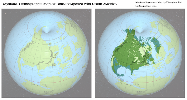
A straightforward comparison between Brun and North America
by LoZompatore.Of course the similarity between the two continents is a well known one, Mystara's map being inspired by Jurassic Earth map of 144 million years ago and so on.
Anyway, I just noticed that is very easy to match the coastlines of the two continents when both Brun and North America are represented through an orthographic map projection. Thorf kindly provided the community with such a map for Brun a few years ago, while the same for North America is widely available; so here is the neat comparison between these two landmasses:
(click on the image for a larger view)
Just for the fun of it, the Known World would correspond to the East Coast region going from Philadelphia to New Brunswick, with New York firmly in the Atruaghin Lands and Glantri City somewhere south of Ottawa. Thyatis City, Karameikos and the Five Shires would all be underwater, just offshore the coast of Maine.
Of course climate zones would not correspond to the real world, because - as you can see from the comparison above - Brun is tilted clockwise with respect to North America by some 20°, pushing all locations of North America's Eastern Coast farther south on the map of Brun (and the opposite is true for the Western Coast: the Sylvan Realm stands at an higher latitude than the corresponding region in Canadian British Columbia).
I am wondering if such a comparison may be useful to introduce some real-workd-inspired details to the rather blank map of Brun (fan material not considered, of course). Some examples might be:
- A long escarpement (or a set of shorter escarpments) in north-eastern Brun following the contours of Hudson Bay
- Low-lying plains in Northern Brun at the locations corresponding to the north-central lakes of Canada
- A stretch of North-South elevated terrain in northern Norwold corresponding to Baffin Island
- Vast expanses of shallow waters offshore the Orc's Head Peninsula and protruding toward the center of the Izondian Deep (the latter covering the Yucatan penisula)
- Several additional small islands north of Frosthaven
- Swamps / basins north of the Black Mountains, corresponding to the westernmost Great Lakes (Superior, Michigan, possibly even parts of Huron)
- The northest part of the Icereach Range (all mountains north of the Great Bay to Frosthaven) is possibly made of not-so-tall mountains, as they lay on the "lowlands" where the real world Hudson Bay is located
- Some long North-South parallel valleys (or a single wide valley) may exist on the western part of the Arm of the Immortals north of Aeryl and Eshu, corresponding to the Gulf of California
Following this approach, geographic details taken from the real world North America are potentially endless.
Hope you may take inspiration from this and enjoy!
