
Caerdania Gazetteer, version 1.0
by Simone NeriFOREWORD: The following material is incomplete and represents a first draft of an attempt to write a gazetteer of the region. It still lacks places and NPCs descriptions. Most of what's already written has to be revised and expanded further. At the moment I have written a rather complete timeline, a short general description of geography and of the government, and the beginning of the description of Ailthan region.
As you will see reading what follows, I've used materials taken from some other authors, in particular Andrew Theisen, which did the first accurate description of this region, and other authors of the Mystaran Almanac as well (Marco Dalmonte Furmenglaive's entry, among others). A special thanks to all of them is due.
I apologise for my English is not all that good, but I hope it's still readable and enjoyable.
****************
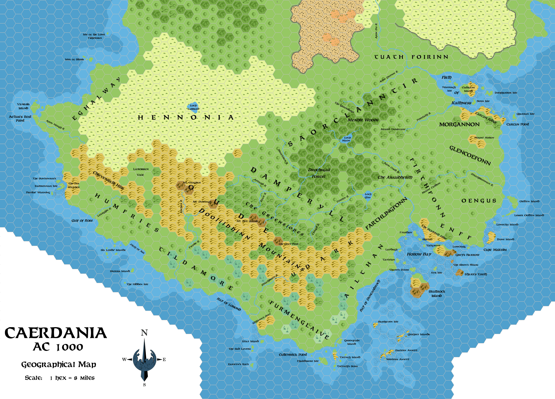
Caerdania is the area that includes the southernmost tip of the Isle of Dawn, south and east of Hennonia. The region, today, is better known for hosting the County of Furmenglaive and the Barony of Caerdwicca, two important dominions of the Thyatian Empire, but in older times it has been the seat of an independent kingdom and its culture has peculiar traits in respect of other peoples of the Isle of Dawn. Today Caerdania is famous as a lonely and sparsely-inhabited region, for its quarrelsome clans - proud warriors and skilled seafarers and pirates - and for its dark past of evil presences that have left a lasting mark on its history.
The following material only cares to detail the Caerdania geographical area - that is excluding Eghalway, Hennonia and anything north of them. Most of the information given here take into account some of my other works published on the Italian MMB, that eventually will be translated in near future - mostly the articles Thyatian Demography (featuring a Thyatian timeline and a chronology of Thyatian emperors within - both of which differ somehow from James Ruhland's version found at the Vaults), History of the Thyatian Government and Ethnographic History of Mystara.
Culture
Basically, the inspiration of Caerdania comes from real-world Scotland and in many ways the timeline follows the main hints of Scottish history, with the Thyatians loosely playing the English part and the Alphatian the French one. Obviously, Caerdania's culture incorporates elements from Aelann (sort of M-Picts), Thyatian and Ostlander ones. The resulting mix could be defined as a late-middle age version of the "Scottish Highlander Vikings" mentioned in M5 - living in a subtropical climate.
Languages
Main tongue of Caerdania is Caerdan (a sort of Scottish Gaelic part of the Goidelic language family); nobles and peasants alike speak it. Thyatian is also spoken by upper classes and in urban areas; it's the official tongue of the government (it's the tongue used to write laws, documents and so on). Alphatian is also spoken, mostly in larger communities which have trading relationships with the Alatians. Trade and meetings with Ochaleans or Nuari are almost always done using Thyatian.
Population
I still have not delved much into Caerdan population issue. As you'll see from the following timeline and descriptions, I think that the inhabitants listed in DotE and official modules (PWAs) are too few for an area put in the middle of south-eastern trade routes and inhabited at least since a thousand years. Moreover, the canonical absence of relevant posts and harbours between West Portage and Furmenglaive or Caerdwicca is senseless, considering the presence of neighbouring Ochalea and Pearl Islands dominated by the Thyatian Empire since AC 0. Therefore, I think that Caerdania should have a higher population in regard to what's listed in official products; this, in my view, justifies the presence of a higher number of villages and towns. This is not to say that Caerdania is like Darokin; it's still a sparsely populated region - but a populated one indeed.
Regarding settlements, all the villages you see indicated in the maps should have between 500 and 1,000 inhabitants; indicated towns should have between 1,000 and 4,000 inhabitants each. A higher number of smaller hamlets should dot most regions of Caerdania.
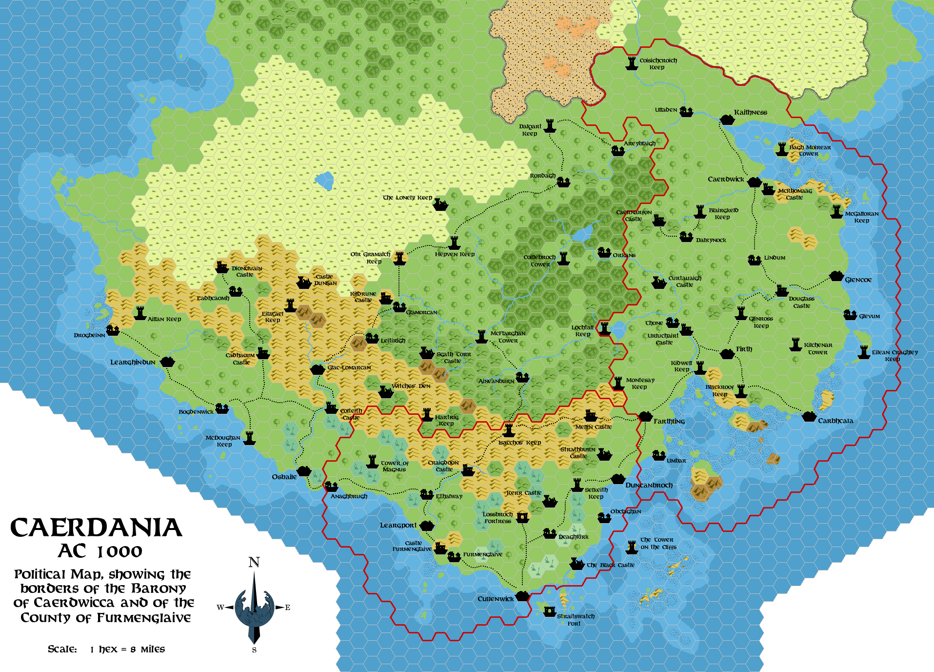
Government
When talking about administration, there are two autonomous political entities in this region: the Province of Meridiona, which includes central Caerdania and the Barony of Caerdwicca; and the County of Furmenglaive. Both those administrative divisions answer to the Thyatian Empire which dominates them.
The Province of Meridiona is ruled by a Governor-General sent by the emperor of Thyatis. It resides at Grosmouth, north of Hennonia, and administers central Caerdania through his officials - Legates, Quaestors and Procurators. Legates command the military forces stationed in the province (they're auxiliary forces, not imperial legions - Meridiona is not a target of foreign attacks), the Quaestors collect taxes for the imperial treasury, and Procurators watch on public order, lying dawn the law and local matters. All these officials are usually assigned to one area of the province, but tend to stay at Grosmouth, or in the place they've chosen as their residence for most of the time. The Governor-General leaves the province administers herself autonomously for anything that's not of imperial interest - that is apart from taxes collection, internal order and defence.
Today, local power in Caerdania is found in the hand of landed nobility as it used to be in ancient times. Landed aristocracy fills the ranks of the clanheads and it's the richest class of the country. The highest title is that of thane, followed by baron and earl (the latter of Northman origin). The titles' pyramid has widened and complicated with the annexation of Caerdania to the Thyatian Empire and the addition of Thyatian titles (like the same 'baron', and moreover 'landed knight', 'count' and 'duke') to local ones; the most prestigious nobleman of the region is in fact the Count of Furmenglaive, followed by the Baron of Caerdwicca. The latter title represents a type of "baronate" different from the native one, and of much higher rank because granted by the Thyatian Senate or Throne; it represents the lowest step in Thyatian landed nobility's rank ladder - but because of this it surpasses in importance and prestige the smaller Caerdan "baronates".
In the past, noblemen have always ruled as they pleased within their lands; the Caerdan crown was satisfied of the way things went on as long as the nobleman paid due tributes to the king's coffers and gave his liege some aid in wars. As there never was another class that could oppose the power of the great noble landowners, their power has gradually increased to the detriment of peasants and small landowners; peasants without land were slowly reduced to the rank of serfs, and only in border areas small landowners have managed to survive with some success. The lack of important cities has forbidden the birth of a middle class that could break the noblemen's supremacy.
With the introduction of Thyatian law in Caerdania, many serfs has been included in the slave class, and this has hugely strengthened the nobles' control on their subject - and this also explains the favour with which thanes have welcomed the annexation of Caerdania to the Thyatian Empire. Freemen were included in the citizen class theoretically endowed with voting rights but practically excluded from participating in elections because of their rather low income.
Caerdania doesn't have a tradition of elected officials or magistrates; only recently the Governor-Generals have managed to impose the duty of electing at least the Quaestors which lay down the law and the officials of villages and towns (called "sheriffs"). Noblemen have not resented these developments, because they make up the largest part of the peoples rich enough to participate in elections.
Single noblemen are advised by councillors and functionaries of various types chosen by themselves; most common ones are seneschals (charged with the administration of the nobleman's direct holdings or with ruling duties when the nobleman is away), castellans (charged with the maintenance and the defence of castles) and bailiffs (local administrative officials and tax collectors). Ruling staffs of the Baron of Caerdwicca and of the Count of Furmenglaive tend to be more numerous and complex; each of those dominion rulers holds moreover authority over a number of lower-rank vassals, which send them tributes and assist them during wartime.
HISTORY
PART 1: Ancient Caerdania
- Before BC 3,000: At this time the Isle of Dawn is inhabited by descendants of ancient human tribes of Asyidhi stock, which have spread over a vast part of the central and south areas of the large island. These tribes have migrated from Skothar after the dawn of man, travelling through (and settling) Bellissaria and the Alatians, and have reached the Isle of Dawn's shores around BC 8,000-7,000.
Other copper-skinned human tribes - descendants of the ancient Oltecindian migrations (around BC 30,000-20,000) that headed from Skothar to Davania - inhabit mostly the forests and wildernesses of the southern Isle of Dawn; many are conquered and assimilated by the later Asyidhi, but some manage to preserve their independence, fighting bravely or retreating on the Great Escarpment.
Rockmen, araneas, small tribes of giants and feys are other possible inhabitants of the pre-cataclysmic Isle of Dawn. - BC 3,000: The Great Rain of Fire. Mystara's axis shifts and the Isle of Dawn moves to milder latitudes, its northern part becoming gradually habitable while its southern one falling into the subtropical climate area. Land bridges linking the Isle of Dawn to the Alatians, Ochalea and Alphatia begin to collapse because of earthquakes and disappear under the waves within some centuries.
- BC 2,900: After the Great Rain of Fire, Caerdania is inhabited by human tribes of hunters-gatherers of Asyidhi stock. The legends of their descendants will tell they had been led here after a great cataclysm by the hero Eithlann, and that's the reason why these tribes will later be known to the Caerdas as "Aelanns" (a misspelling of the name of the eponymous hero). It's possible that these legends have some truth, and that the Aelanns be a tribe of Asyidhi previously living on Aegos or on Ochalea, which soon after the Great Rain of Fire migrated in the southern Isle of Dawn. Anyway, the Aelanns soon adapt to live in the subtropical forests of Caerdania, and in surrounding plains, coasts and steppes.
- BC 2,200: Perhaps fleeing competition with other tribes, a group of Asyidhi tribes moves to the Known World through the Redstone landbridge. They settle in the great basin of a large river, north of the Taralai lands and Taymoran and elvish holdings. They're the ancestors of the Nithians.
- BC 2,000: It's a time of migrations and invasions for the Isle of Dawn. From the west, through the Redstone landbridge, come from Brun the Albans, a Neathar-descended human branch, whose ancestors have settled among elves in Genalleth. These numerous peoples spread all over the northern and western areas of the Isle of Dawn, settling in the lands around those belonging to Asyidhi tribes or fighting and assimilating them when lands aren't enough.
Almost in the same time, Antalian-descendent tribes called the Helska come from Norwold and settle in the northern Isle of Dawn, fighting against the newly-arrived Albans. These wars cause a series of people movements, that pull the southernmost tribes of Albans in the lands of the Aelanns.
While first contacts between Aelanns and Albans had been peaceful, now the Albans invade the lands of the Aelanns from the Shadow Coast, beginning a time of tribal wars in this region. The Aelanns gradually lose terrain against the more numerous and aggressive opponents. - BC 1,900: After a century of tribal wars, Aelanns manage to preserve most of their lands against the Alban tribes, that now call themselves the Caerda. The Caerda settle in the forests of modern Meridiona north of Hennonia steppes; they call their southern neighbours Aelanns (as said above), and their lands "Aelannia". Aelanns continue to live in Aelannia (where there are sedentary tribes) and Hennonia (where they continue to live as nomadic hunter-gatherers).
- BC 1,500: Bronze is introduced among Aelanns; their culture develops peculiar features, but is influenced also by the Caerdas' one, and is characterised by standing stones, funerary mounds and by fortifications (broch in Caerda language - they're low tower with round basis) built on hilltops.
- BC 1,400: Starting from some brochs, expanded to become small fortified villages, the first native kingdoms of Aelannia are born.
- BC 1,200: First contacts between Aelanns and Nithian traders and seafarers; they probably introduce iron technology among Aelanns.
- BC 1,150: In those years the Nithians begin to penetrate more deeply into Caerdania, founding their first trading posts of the coasts of Humfries, Tildamore and Hennonia regions. Even if these settlements are only small waystations used to trade with the Aelanns and as stops toward other explorations and colonisations, they'll be instrumental for the future Nithian conquest of the Alatians and of Thothia. The Aelanns establish an advantageous trade with the Nithians, selling slaves, timber and herding products for manufactured goods, tools and weapons.
- BC 1,100: The Nithians conquer Thothia and found there a colony; other colonies are founded in the Alatians in following years. The rise of Nithian presence in this area brings an increase of the contacts with Aelanns, against some kingdoms of which the first border skirmishes occur.
- BC 714: The explorer Khendaras is the first Alphatian to circumnavigate the Isle of Dawn and to leave in the record of his expedition (the work known still today as The Periple) a description of Aelannia's peoples. The circumnavigation of Khendaras, even if the same voyage had already been completed by the Nithians, is considered the first navigation around the Isle of Dawn because all the discoveries of the Nithian civilisation and been lost with the later erasure of the Nithian Empire from historical memory done by the Immortals (BC 500).
- BC 698: Civil war breaks out in the Nithian Empire following the secession of the Nithian dominions located on the eastern shores of the Isle of Dawn, headed by the pharaoh of Thothia. Aelanns are recruited by both parties as mercenaries; the lining up of this or that Aelann kingdom with Nithia or Thothia determines jealousies and rivalries even in Aelannia.
- BC 608: Near modern Bogdenwick, in Tildamore, a great battle is fought between Nithian and Thothian forces; the Thothians can count on the alliance of many Aelann kingdoms; the battle is a decisive Thothian victory and ultimately turns away from Aelannia the Nithian presence. Afterwards, Thothians retreat, preserving a feeble alliance with some of the more influent Aelann kingdoms, while the Aelanns' reaction brings to the destruction of Nithian outposts in the area and to the almost complete erasure of any trace of the Nithian culture in this region.
In Aelann - and Caerda afterwards - mythoi this event is remembered as the final battle of Aelanns and their allies against the evil invader King Thanos (an imaginary name, probably remembering that of the Immortal Thanatos, favoured deity of the Nithian pharaoh at this time).
PART 2: The coming of the Caerdas and the Alphatian invasion
- BC 523-514: A confederation of Caerda tribes coming from modern Meridiona and headed by the chief Ardhan mac Gabrán, invades Aelannia occupying and settling a vast area of the country, including the modern regions of Humfries, Tildamore and Oude. These tribes form the Caerda kingdom of Dál Arden (a term probably drawing from the ancient Caerda for "land of Ardhan").
- BC 500: The end of the Nithian Empire and its erasure from the memory of the living, decreed by the Immortals, haven't great consequences on Caerdania; histories of past relationships with the Nithians become myths shrouded in the fogs of epic tales.
- BC 490-480: Around these years the small Aelann realms, which since decades suffer continuous attack by the Caerdas of Dál Arden, decide to unite in confederation, electing a "High King of the Aelanns" which rules - effectively only in times of war - over the other Aelann dominions, each of which continues to have anyway its ruler. In the following decades many wars between the Aelanns' "kingdom" and that of Dál Arden will break out.
- BC 470-430: In those decades many frequent trade relationships take place with the Alphatians, which sphere of influence is widening to include the Isle of Dawn thanks to the gradual decline of Thothia. While wars between Aelanns and Caerdas of Dál Arden continue, the kings of Dál Arden launch also naval attacks in Ochalean and Alatian lands, coming to be known and feared as pirates and raiders.
- BC 424-390: Under King Comgal the kingdom of Dál Arden reaches its greatest extent, ruling also over modern regions of Udark, Furmenglaive and Damperyll. Toward the end of his reign (BC 395), Comgal suffers a bad defeat against the tribes of Hennonia and then loses control of northern Humfries and of Oude.
- BC 390-371: The new king of Dál Arden, Dungal, son of his predecessor Comgal, expands even more his kingdom, conquering Aithlan and taking personally part to various raids against Alatian and Ochalean coasts. Alphatians, interested in the preservation of their control over the Alatian region and in the defence of the trade between these islands and their empire, start to prepare an expedition to reduce the peoples of Aelannia into submission.
- BC 370-365: The Alphatian general Zentharas leads and expedition against the Aelanns; Alphatian superiority is soon evident during the fights and the conquest is slowed only by the difficulty to advance in wild areas, almost-unknown to the Alphatians, as Caerdania is. In BC 366, in the battle of Mount Hoban, Aelann forces are forced into battle and seriously defeated by the Alphatians. The Alphatian Empire however is not interested in the conquest of the whole region, which don't have any economic importance; thus, general Zentharas grants to the Alphatians the domain of eastern coasts (modern Firthfonn, Morgannon, Glencoefonn, Oengus and Enff), building a bridgehead from which to intervene against the Aelanns when needed. In the following year (BC 365), Zentharas defeats at sea the Caerda fleet of Dál Arden and threatens the kingdom of invasion, getting a tribute in exchange for peace.
- BC 360-340: In those years the Alphatian power over eastern coasts of Caerdania strengthens with the building of some outposts and fortifications, and the appointment of unscrupulous Alphatian governors that brutally oppress the population, sending part of it into slavery in other provinces of the empire and plundering at their whims the weak surrounding Aelann kingdoms. The only Alphatians that comes in this far region are the governors, the garrison mercenaries and their commanders. The kingdom of Dál Arden and the Aelann confederation nevertheless preserve their independence, even if only as vassals of the Alphatian Empire.
PART 3: The birth of the Kingdom of Caerdania
- BC 318-317: Cáedrad mac Ciláenn, king of the small Aelann kingdom of Mordriu (located in modern Oude), inherits from his mother the kingdom of Dál Arden and moves with all his forces to conquer the other Aelann kingdoms, which then unify to defend themselves under the leadership of High King Talorcan VIII. The Aelanns are defeated in the battle of Deltenstan (BC 317) and Cáedrad invites to the peace talks to be held at Thone King Talorcan VIII and the chiefs of the most important royal families; there, he has all of them killed and invades what remains of the Aelann realms, conquering them with ease.
- BC 317-305: Rule of Cáedrad mac Ciláenn, which is crowned in Thone "King of Caerdas and Aelanns". Within a few years the new king eliminates all opponents still resisting him in Aelannia and then reigns over an unified country. Under his rule, the even stronger presence of the Caerdas leads to the "Caerdisation" of the Aelann culture; Caerda language becomes the official tongue of the kingdom, which begins to be called with the name "Caerdania" (the name this region is still keeping to this day). Within decades, the name "Aelannia" falls out of use and the inhabitants of this region begin to call themselves "Caerdans".
Cáedrad leads many expeditions against the Alphatians, attacking their holdings on the Caerdan eastern shores and launching raids against the coasts of Aegos and Ochalea, but suffering also counterattacks by Alphatian governors, that even manage to penetrate into the heart of his kingdom (even if without durable consequences). - BC 277: Thyatian seafarers reach Caerdania for the first time; they establish the first trade contacts with Caerda kings of this region and carry out pirate raids against the Alphatian holdings.
- BC 58: Findláich mac Coluim, thane of Morgannon, which family has been persecuted and humiliated by King Bethlad of Caerdania (BC 64-58), decides to avenge himself against his liege: he rises against the king, defeats him on the battlefield and has him killed, taking the crown for himself. Prince Crinán, son of Bethlad, takes refuge among the Alphatians.
- BC 58-41: Rule of Findláich mac Coluim. The new usurper king rules tyrannically, killing without second thoughts all his opponents, until rebellion spreads in Caerdania. Alphatians, in the middle of their political decline and not interested at all in local matters, only after many years agree to support the rightful heir to the throne, Prince Crinán. He, supported by Alphatian forces, invades Caerdania, defeating Findláich in the battle of Barnalaine (BC 41) and besieging him in his castle at Craggandich. During the final assault, Findláich is killed in combat and the prince is crowned Crinán III, new king of Caerdania (he'll rule until BC 6).
Unknown to all, the usurpation of Findláich has been secretly financed and spurred by the Thyatian Ordo Magna, the secret organisation born in Thyatis during the Alphatian occupation and vowed to free the motherland from Alphatian clutch.
Following the defeat of Findláich, the Alphatian Empire decides to send Thyatian mercenary forces in this region to keep order and defend the new king. This way, in following decades, the Ordo Magna infiltrates deeply in this strategic region, allying itself with nobles and lords displeased by the current rulers of Caerdania. - BC 2-0: Thyatis fights the Struggle for Freedom against the Alphatian Empire; the war upsets almost all the Alphatian Empire when many revolts - most of which have been spurred by Thyatians - break out in different areas of the empire.
Caerdania is also dragged in the war. There, many thanes lead a rebellion against King Domnall Bán III (brother of Crinán III), and the uprising is immediately supported by Thyatian mercenary forces garrisoned in Caerdania. Domnall Bán III flees among Alphatians, while the Thyatians put on the throne an Ordo Magna's creature, Edmund I mac Finns. The forces of the new king and of his supporters swiftly subdue the few allies of Domnall Bán III which still support his cause, and wrest control of the country from them.
King Edmund I declares immediately war against Alphatia, siding with Thyatis and its allies, launching raids against enemy shipping and pulling Alphatians away from the Strait of Furmenglaive. - AC 0: The Treaty of Edairo ends the Struggle for Freedom. The Thyatian ruler, King Lucinius Trezantembium, proposes to King Edmund I to take part in the new Thyatian league to be formed together with other countries that successfully rose against Alphatia (first and foremost Ochalea and the Pearl Islands). Edmund I is instead convinced by the Ordo Magna and by general Zendrolion Tatriokanitas, thanks to a mix of blackmail and persuasion (the Ordo Magna actually has him in its fist - in fact Edmund manages to hold the throne only thanks to the plots of this secret society), to support the conspiracy aimed to the assassination of King Lucinius; in exchange for his support - and for the assignment to Thyatis of the regions of Humfries, Tildamore and Furmenglaive -, Zendrolion assures him about the independence of his country.
The plot of Zendrolion succeeds and he's crowned first emperor of Thyatis; his propaganda has effectively prevented any form of true opposition, and those rising their heads anyway are swiftly silenced. The new Emperor Zendrolion I grants to Edmund I the throne of Caerdania and the independence of his kingdom, with which he signs a "perpetual" alliance. Areas of Caerdania ceded to Thyatis are organised in the Province of Caerdania and put under the authority of a military governor.
PART 4: The mac Finns dynasty and the Thyatian dominion
- AC 0-33: Reign of Edmund I mac Finns. The Caerdan king takes as wife Martiana, a Thyatian noblewoman with an Ochalean mother; the queen plays a central role in the introduction of the advanced Thyatian civilisation in Caerdan society, under many aspects still primitive and barbaric. Edmund settles his residence at Thone, which will become the capital of Caerdania.
- AC 64-83: Reign of Alexander I mac Finns. Alexander is a great admirer of Thyatian culture and imports in Caerdania's administration many advanced elements inspired to the Thyatian model. The Thyatian tongue begins to spread in Caerdania, even if Caerdan one continues to be prevalent. The king, as sign of friendship also because of the help given to the empire in its war against Alphatia of AC 69-73), receives from the Thyatians money and technical resources to build new strongholds, infrastructures, roads and bridges.
- AC 118-124: At the death of Alexander II Caerdania falls in a dynastic crisis; the only heir of the king is his daughter, Martiana, which is still very young. The thanes set up a regency council, but the authority of this assembly is contested and many other noblemen ignore it at all, behaving as independent rulers and threatening to break up the kingdom.
Thyatian Emperor Alexis I, interested in preserving the control of the strategic region of Caerdania, offers to the regents the marriage of his son, imperial Prince Leontius, with the heir to the Caerdan throne, Queen Martiana; however, during the trip toward Thyatis City, the ship of Martiana is hit by a storm and the queen disappears under the waves (AC 124). - AC 124-128: The government stays in the hands of the regency council, weaker and weaker and lacking real authority over the kingdom, that starts to break up. Many thanes by now behave like independent rulers, ignoring completely the council's authority and taking advantage of the lack of a king to look after their personal interests. Feuds and internal strife break out between enemy thanes.
- AC 128-131: The Thyatian Empire, fearing disorders and the loss of its influence over the area, intervenes to defend its own interests in Caerdania. Thyatian forces penetrate in Caerdania, forcing the regency council to declare the imperial Prince Leontius, son the Emperor Alexis I, "Protector of Caerdania" and arbiter of the situation.
In AC 129, Leontius succeeds to his father of the imperial throne of Thyatis and leaves the Caerdan situation in the hands of a Thyatian governor. A faction of the nobles starts to ask Thyatis the choice of a new king for Caerdania, to put an end to the disorder that reigns in Caerdania at the moment. In the following year, war breaks out between Thyatis and the Alphatian Empire (AC 130-136), and this diverts Leontius III's attention from Caerdania.
At the end, to prevent the Alphatians to take advantage of Caerdania's disorders, Leontius III decides to call a meeting of the thanes at Caerdwick (AC 131), in which the Thyatian governor, charged with full powers by the emperor himself, proposes as new king the nearest heir of the mac Finns dynasty, Malmore Kilconath. In spite of many thanes' doubts about this choice, imperial pressure makes sure that Malmore is crowned king of Caerdania. - AC 131-135: Reign of Malmore Kilconath. The new king is a puppet in Thyatians' hands; he's always accompanied and controlled by imperial functionaries, which treat the thanes in an arrogant way, never losing occasion to remark the superiority of the empire in regards to the thanes and to the king himself.
Intelligent and thoughtful, Malmore sees in the alliance with Thyatis the only way for Caerdania to survive as an independent kingdom, and, out of love for peace, suffers humiliations both by the Thyatians, which consider him a feeble man, and by his noblemen, which despise him.
After some years, a clique of Caerdan thanes decides to ask support for an uprising to Alphatia, and the empire agrees. Malmore, in order to keep some control over the country - which is mostly hostile to him -, agrees to sign the treaty of alliance with Alphatia (AC 135).
Thyatian forces however defeat the Caerdan army at Umbar, and in the battle Malmore himself is taken prisoner. At Cullenwick, Malmore is forced to abdicate in favour of the Thyatian Empire and is led prisoner in the jails of the Thyatian capital (he'll be freed in AC 141, but will be forced to stay in the capital, without chance to go back in his homeland). - AC 136: Thyatian forces, after the removal of Malmore and after the end of the war with Alphatia, crush once and for all the Caerdan rebellion, putting to death the thanes which are held the worst responsible of the uprising and of the country's betrayal in favour of the Alphatians, and destroying some strategic castles. Caerdania is occupied and pacified, the whole region annexed to the Thyatian Empire and divided into two more provinces, Cardania Ulterior and Aelannia - the existing province of Caerdania receives the surname of Maritima to distinguish it from the former of the two new provinces. In the following years, the country is put under a harsh military control. Caerdans harvest the wish of independence but, lacking a strong guide, in those years they settle under Thyatian dominion.
- AC 150-250: In this period the Thyatian dominion over Caerdania stabilises thanks to the favours that thanes and clanheads receive from Thyatian government - generally the gift of new lands and the granting of Thyatian citizenship to themselves and their families. They're still kept out of imperial administration, as well as the larger population is negated the rights of Thyatian citizens. At this time, many Caerdans are reduced into slavery by their patrons and sold because of their debts.
PART 5: The Wars of Independence
- AC 280-300: Thrills of revolt run stronger in Caerdania because of the ruthless taxation and of the indifference of Thyatian governors in front of the needs of the populace; the country's resources have been systematically plundered by the empire and Caerdan thanes and clanheads have been constantly scorned by the arrogance and the greed of the governors.
Agents of the Storm Soldiers, secretly intent in preparing a coup to seize the empire, stir up the wish for freedom and justice of the Caerdans in order to cause an uprising in this area. - AC 300: In a village of Oude, Offclyde, an uprising breaks out when the wife of a young nobleman, Arthgal Reamharmath, is raped and killed by a Thyatian officer. The revolt quickly widens to include neighbouring communities, which choose Arthgal as their leader and form an army. Many thanes, in the hope of riding the revolt to recover the control of the country, support Arthgal.
- AC 300-312: The First War of Caerdan Independence (AC 300-332) begins. Under the skilled and charismatic guide of Arthgal, the Caerdan rebels put the Thyatian garrisons to harsh tests, ultimately forcing the governors of Aelannia and Caerdania Ulterior to retreat in Caerdania Maritima. Thus Arthgal manages to conquer the whole Caerdania and to obtain the alliance of many other thanes.
To quell the rebellion, Emperor Alexian II sends reinforcements to the armies of his governors in Caerdania from Ochalea and from the Isle of Dawn. The Thyatian army is however badly beaten by the Caerdans led by Arthgal in the battle of Loweskyle Bridge (AC 302). After this success, the Caerdan forces invade the Province of Caerdania Maritima, seizing the whole region. At Duncanbroch, Arthgal is crowned by the council of the thanes "Warden of Caerdania", but he's immediately clear about the fact that his major interests go more toward the defence of common folks than toward the defence of the thanes' privileges.
Determined to crush the rebellion, Emperor Alexian II sends a strong imperial army from the motherland, led by general Leontius Kelthemodorus, to reconquer Caerdania. The cunning Thyatian general takes advantage of the dissent of some thanes - jealous of the favour of which Arthgal benefits in the eyes of common folks and fearing to lose the privileges that until now the Thyatians had granted to those belonging to their class, in the case of a Thyatian victory - to put Arthgal on the defensive. Kelthemodorus thus secretly bribes some thanes with offerings of lands and money, then penetrates with the imperial army deeply into Caerdania, occupying Duncanbroch and heading toward the north-east. Arthgal, with a large army, meets him at Farthling but, during the battle, the bribed thanes betray him leaving unexpectedly the fray and the Caerdan army is defeated (AC 304). Arthgal manages by chance to prevent his seizure by the Thyatians.
The defeat of Arthgal allows the Thyatian army to re-establish order in the country, mostly thanks to the fact that many thanes now side again with Thyatis, and those that doesn't are hit by seizure of their lands or execution. Arthgal, with a group of supporters, goes underground, continuing to wave guerrilla against the Thyatians and letting the legend of his actions grow in the whole Caerdania.
As time passes some noblemen, judging the decision to stay under Thyatian Empire awkward, take arms against the empire again and give one more time their support to Arthgal, putting themselves under the leadership of two descendants of cadet branches of the old mac Finns dynasty: Cynan Thynn and Maelduin MacRhun. Thus the fire of rebellion sparks again.
In AC 311 Arthgal is finally seized by Thyatian authorities, brought to Beitung and executed - but this event doesn't stop the rebellion, which now is led by the two heirs of the mac Finns and widens again, forcing the Thyatians to retreat from the Province of Aelannia. However, harsh contrasts manifest between Cynan and Maelduin over who of them has more rights on the crown of Caerdania; the issue is bloodily resolved when Maelduin manages to have his rival killed and goes to Thone, where a small assembly of few thanes crown him king of Caerdania (AC 312). Maelduin hires an army, but few weeks later is defeated by the Thyatians at Gothven and has to retreat in the Province of Aelannia. - AC 313-320: The revolt of Hattias, the following death of Emperor Alexian II and the civil war within the Thyatian Empire (AC 313-320) give new impetus to the rebellion of Caerdania led by Maelduin, which gathers even more followers, also among the thanes - now that Arthgal is dead, they no longer fear to lose their privileges nor the control of the country.
By AC 320 Thyatis keeps only Caerdania Maritima and a couple of castles in Ailthan. The weak rulers that have succeeded in Thyatis City during the civil war have managed to send only few reinforcements to the Thyatian troops fighting in Caerdania; a new offensive of the Thyatian army is nevertheless stopped in the battle of Broch Fyrth (AC 320), in which Maelduin manages at the end to obtain a victory over the imperial army.
Strengthened by the victory, Maelduin gathers a new assembly of the thanes at Duncanbroch. This time noblemen from all the country are present and he's crowned king of Caerdania as Maelduin I. The Thyatian Empire refuses to acknowledge the authority of the new king, which by the way immediately asks the support of the Alphatians, which at the moment are involved in a war against Thyatis (AC 316-328), that are more than happy to send him reinforcements. - AC 320-333: Maelduin continues the war against Thyatis on Alphatia's side, attacking Caerdania Maritima now only poorly defended, and launching raids even against modern Meridiona and areas of the Alatians islands under Thyatis' control. Maelduin tries to publicise among the people of Caerda ancestry (including those of Meridiona) the idea of a "Great Caerdania" - an unified kingdom that will reunite the Caerda people under a single banner. However, the Caerda peoples of southern Meridiona, too much Thyatianized and loyal to the empire, are not spurred by his claims.
Thanks to Thyatis' involvement against Alphatia, Maelduin can dedicate himself to strengthen his position in Caerdania: the thanes held responsible of supporting the Thyatians, or the moderate ones that according to Maelduin's view haven't given an adequate support to his cause, are persecuted with tributes, fees, seizures and convictions. Many of those noble families (among which there's the Thynn family) flee from Caerdania, seeking refuge in Ochalea, where they receive lands to settle from Thyatis; many others stay in Caerdania, where they're forced to suffer revenges and retaliations by the king or by rival thanes.
In AC 328 the war between Thyatis and Alphatia comes to an end, but in Caerdania the Thyatians maintain by now only few fortified positions in Caerdania Maritima. After few more years of skirmishes, the new Thyatian Emperor Alexandrion I decides to put an end to the Caerdan issue (given the bad situation in which Thyatis has found herself after the civil war) and agrees to acknowledge Maelduin I as king of Caerdania with the treaty of Cullenwick (AC 332), which de facto ejects Thyatian presence from the lands south of Hennonia, giving MacRhun rulership over whole Caerdania. However, Alexandrion I obtains to have in the treaty a clause allowing the exiled noblemen (those wishing to go back home) to be back in Caerdania, and preventing the king and his allies more convictions against those thanes.
Maelduin I dies the following year (AC 333), leaving the throne to his five years-old son, Dunmail II. - AC 333-339: Reign of Dunmail II. The newborn kingdom of Caerdania has immediately to pass through a time of troubles, in which rulership is given to a regency council which rules in the name of the young king. In AC 337 the clanheads of families fled in Ochalea during the persecutions of Maelduin I launch an expedition (with silent Thyatian support) to support the claims to the throne of the son of Cynan Thynn (the rival to the throne of Maelduin I killed by him in AC 312), Edoard Thynn. The invasion force, thanks to a plan accurately prepared before, gets the support of many noble families persecuted under Maelduin I, and obtains some successes, including a great victory at the battle of Pafflin Bogs. Few months later, however, the forces of the thanes loyal to Dunmail II lay an ambush to Edoard Thynn's army at Oddam, north of Farthling, routing it and forcing Edoard to seek refuge in Ochalea again (AC 337).
There, Edoard asks Thyatis for open support. Alexandrion I decides ignore the treaty of Cullenwick and to recognise him king of Caerdania in exchange for the transfer to Thyatis of the old Province of Caerdania Maritima and of the submission of Edoard as vassal of the empire, and sends the imperial army in the region.
The Second War of Caerdan Independence begins (AC 337-362). Thyatians immediately obtain a crushing victory over Caerdans at the battle of Benlagh Hill (AC 338), following which loyal supporters of Dunmail II bring the young king and his court in Aegos, where the Alphatians give him hospitality as king in exile. Supported by the Thyatian army and by a small part of the thanes, Edoard Thynn gathers the council of the thanes at Thone and is crowned king of Caerdania (AC 339). - AC 339-365: Reign of Edoard Thynn. The new king declares void at once all grants made by Maelduin I in favour of his supporters, makes seizures against those who benefited from them and gives lands and titles to the few Caerdan nobles which support him (and which are the same that were persecuted by Maleduin I); he gives Thyatis, as promised, the old Caerdania Maritima and declares himself a vassal of the empire.
Excluding that of his nearest allies, the support of Edoard in the country is scarce, and weakens even more when Alexandrion I, pressed by the Senate (tired after years of excessive expenses caused by the civil war and by the long struggle against Alphatia) and having reached his aims, dismisses most of his forces stationed in Caerdania. Edoard's position becomes swiftly more difficult and even worsens when a feud breaks out between him and some of his allies, in particular Girig MacDonald, over the transfer of some lands in Udark; the faction loyal to Dunmail II becomes more and more threatening, and Edoard prefers to retreat once more in Ochalea, where he possesses some lands, leaving the rulership of the country to his faithful lieutenant, Lulach Duffscone (AC 339).
The Thyatian Emperor Alexandrion I, fearing to lose the lands assigned to the empire by Edoard in case the rebels get the upper hand, prepares a new invasion of Caerdania, this time charging of it the imperial forces stationed in Ochalea (the Senate doesn't allow him the use of more money to hire a new army, and he's obliged to feature this war as an internal rebellion instead of a war against a foreign enemy). The Thyatian army lands in Furmenglaive, penetrating deeply inside the country, but it doesn't manage to force the rebel army to battle (AC 340), and so, within a season, it goes back to Ochalea.
Immediately after the departure of the Thyatians, loyalist forces attack the weakened Caerdan army led by Duffscone, defeating it in the battle of Murrlean (AC 340); Duffscone himself is killed during the fight.
The situation seems to precipitate when the Alphatians show the intent to intervene to support Dunmail II and bring him back on the throne. Alexandrion I, which since some years is coveting and carefully planning a war against Alphatia to reclaim provinces on the northern Isle of Dawn lost during the war of AC 316-328, takes the chance of the Alphatian support given to Dunmail II to convince the Senate of the need of this war, and starts to recruit a new imperial army to be used on the Isle of Dawn.
Meanwhile, the Thyatian emperor orders to the imperial naval forces quartered in Ochalea and Pearl Islands to launch swift raids against Caerdania, ravaging the south-eastern coasts of the region (Morgannon, Glencoefonn, Oengus and Enff) with the aim to discourage there a possible Alphatian landing in favour of Dunmail II (AC 341); loyalist forces retreat inland. At the same time, Alexandrion I has a series of strongholds built in areas of Caerdania under Thyatian and King Edoard's control, in the hope of strengthening once and for all the Thyatian grasp on these lands. King Edoard returns in Caerdania and settles his residence in Firth (AC 341).
As the new war against Alphatia in the northern Isle of Dawn outlines at the horizon, Alexandrion I doesn't want to waste money anymore on the war in Caerdania. He defends the country with mercenaries and auxiliary troops, and he gives command of them to Thyatian generals, trusting not so much the authority of the still weak King Edoard. The support of which Edoard benefits inside the country is all but worsened by this lack of trust; many nobles abandon his cause while Thyatian forces carefully defend only Caerdania Maritima; at the end Edoard controls nothing more than his keep at Firth and his dominions.
When in AC 343 war finally breaks out between Thyatis and Alphatia, Thyatian support to Edoard's cause weakens even more. Unforeseen difficulties on the northern front lead Thyatis to move in other areas a large part of its forces still stationed in Caerdania, charging the governors of Ochalea and Pearl Islands of the defence of the region. King Edoard, feeling himself in danger, leaves Firth (AC 344) and flees again in Ochalea; the town falls into loyalists' hands (AC 345), which then penetrate also in Caerdania Maritima, officially a Thyatian dominion (AC 346), thus reconquering the whole Caerdania.
The situation stalls for some years, with the two empires involved in other areas. Finally, the loyalist thanes convince the Alphatians to finance an expedition of the young Dunmail II in order to set him on the throne again. The aim of the expedition is Ochalea, where a Thyatian army and King Edoard are stationed - the defeat of both will determine the definitive collapse of the Thyatian power in the region. However the expedition is badly-prepared and resolves in a disaster at the battle of Chengdu Reefs (AC 353): Caerdan and Alphatian forces land on Ochalean shores, where they're engaged and turned back by the enemy while their fleet is attacked on all sides and destroyed. His army annihilated, Dunmail II falls prisoner to the Thyatians, which hold him as hostage in Ochalea.
So, with a small number of Ochalean and Nuari forces, King Edoard is able to invade Caerdania again (AC 354), but the Thyatian troops, following the orders of Alexandrion I, mustn't push themselves beyond the reconquest of Caerdania Maritima; thus, apart from the conquest of some small villages and forts belonging to Caerdania proper, the invasion meets few successes. After the capture of Dunmail II, the loyalists' leadership passes to Maelduin MacConnad, chief of an important Caerdan clan and nephew of Dunmail II, which in the course of the following years (AC 356-361) gradually manages to recover lands from King Edoard and his few forces.
This time it seems rather obvious that King Edoard's cause is doomed and that he doesn't have any more support among Caerdans. Moreover, the very long war against the Alphatian Empire has left Thyatis in lack of money and forces, so that its involvement in the war has slowed to the point of allowing the Alphatians to retake many holdings on the northern part of the Isle of Dawn. Because of this, eventually Alexandrion I persuades King Edoard to abdicate in his favour - something that he does with great pleasure, retreating in his Ochalean lands (where he'll die in AC 366); Alexandrion I agrees to free Dunmail II and to acknowledge him king of Caerdania in exchange for a ransom to pay with the transfer of Caerdania Maritima to Thyatis and with a tribute to be paid for ten years. Peace is thus re-established in the area after nearly a century of wars (AC 362). Some years later a peace treaty is also signed between Thyatis and Alphatia (AC 365).
PART 6: The Kingdom of Caerdania under the MacRhuns and the MacConnads
- AC 365-380: Reign of Dunmail II MacRhun. The capital of the new kingdom is set in Duncanbroch. Caerdania is troubled because of taxes imposed by the king in order to pay the tribute to Thyatis; the payment is interrupted many times, but at the end it's paid off wholly in AC 378. Some years before that, Dunmail II had to suppress an uprising of some nobles (AC 370), displeased by the wish of the king to cede the throne to a Thyatian candidate after his death as payment for the remaining part of the tribute; among these rebels there was also Maelduin MacConnad (viable candidate to the throne and leader of the loyalists during the past wars), which was jailed. The king dies without male heirs, and the throne passes to his nephew Maelduin II Mac Connad, nearest relative of the dead king, which is freed by other noblemen.
- AC 380-399:Kingdom of Maelduin II MacConnad. His reign is rather peaceful, also because the king is a rather inactive character. Various skirmishes against Thyatis take place in the years AC 389-397, and they intensify in the last years of Maelduin's rule, when the Thyatians manage to sack the Caerdan capital Duncanbroch; soon after, the imperial forces are defeated at Ethwy (AC 397), and peace is re-established. At the death of Maelduin II, the kingdom passes to the second child of the king.
At this time, the administrative reform of the Thyatian Empire begun by Emperor Tiberian III takes place, and is continued by the following Emperor Gabrionius I. The Province of Caerdania Maritima is thus divided into the two Provinces of Furmenclavia (modern Furmenglaive) and Caerdania Maritima (modern Tildamore and Humfries), which are included in the Diocese of Bosphora Australes ("southern straits"), which in turn is part of the Prefecture of Ochalea et Perlarum ("Ochalea and Pearl Islands"). - AC 399-415: Reign of Maelduin III MacConnad. A weak king, he gives the control of the kingdom to his son, Prince Dunmail. He has to bear another Thyatian invasion in AC 408-415, during which contrasts emerge between Prince Dunmail and his uncle Angus; Prince Dunmail is then mysteriously assassinated (AC 411). Caerdan forces which have invaded Furmenclavia to sack Thyatian lands, are seriously defeated at the battle of Yeaverdon Hill (AC 411). Fearing for the life of Godric, the other son of him, King Maelduin III sends him to Aegos in secret, but the Thyatians discover his attempt and intercept the prince and his bodyguards, capturing them and holding them captive (AC 414). Maelduin III dies soon after because of grief, while the newly nominated regent, his brother Angus MacConnad, signs a truce with Thyatis.
- AC 415-446:Reign of Godric I MacConnad. The new king is a captive of the Thyatians, and stays so for fifteen years because of the refuse of the regent Angus, his uncle, to pay the ransom due to the empire. At the death of him (AC 429), eventually the thanes supporting Godric manage to pay the tribute to Thyatis, and the young king is freed; Godric is finally back in Caerdania in AC 433. He rules with an iron fist, persecuting the members of his family that have supported his uncle Angus and renewing an alliance with the Alphatians to defend himself from Thyatis. During his reign the first spreads of lycanthropy and vampirism happen in south-western regions of the country and in the north - perhaps caused by contacts with Minrothaddan traders - and they cause dismay, fear and violent reactions among the population.
In AC 446, the king is assassinated by a group of his relatives led by Dugald MacConnad (uncle of Godric and descendant of Maleduin II and of his first wife); the assassination is part of a feud broken out between the king and the descendants of the first wife of Maelduin II. Caerdan authorities pursue the peoples responsible of the plot, sentencing to death both Dugald and his grandson. - AC 446-470: Reign of Godric II MacConnad. Son of the predecessor, he rises to the throne when still young (he has seven years) and the government goes in the hands of the regents belonging to the Strathburn family, which are called "the Black Strathburns" because of their always gloomy and stern mood. The regents show some sort of tolerance toward cases of vampirism and lycanthropy - and this lead many peoples to suspect that some members of their family are affected by those curses. In AC 458 Godric II is declared of full age and begins to fight the Strathburns in the attempt to free himself by their influence; accused to host lycanthropes and vampires among their ranks, the Strathburns have to fight the king in a civil war (AC 461-464), after which they're thrown out of the country, their lands seized by the king. The Strathburns take refuge among the Thyatians, that grant them lands and authority in the Caerdan areas under their control, enraging Godric II. The king launches an attack against the Thyatians in AC 469, but during the siege of the Lossbroch fortress he's killed by a disintegrate spell cast by a Thyatian wizard. The Caerdans retreat, re-establishing peace (AC 470).
- AC 470-497: Reign of Godric III MacConnad. The new king is young (ten years old) and regency is assumed by the Douglass family. Once he has reached full age (AC 478), Godric III tries to diplomatically approach Thyatis by stirring pirate raids against Alphatian shipping and signing an alliance with Thyatis in AC 483, which makes him very unpopular.
Some time later a feud breaks out between the king and his two brothers, accused to practice necromancy; pursued, the two princes try to flee: one is assassinated, while the other, Alexander, takes shelter among the Furmenglaive family, in Thyatian lands. Enraged, Godric III then denounces and declares void his alliance with Thyatis. Alexander invades Caerdania with Thyatian support and enters a league with other rebel nobles within the kingdom; after a brief war (AC 489-491), Godric III is taken prisoner by his opponents and jailed in Duncanbroch castle. Alexander assumes the leadership of a regency council and a new government is formed, but the Thyatian army retreats soon after from Caerdania because of the lack of money, leaving Alexander in a weak position.
Bribeing the members of the new government, Godric III manages to flee from Duncanbroch dungeons in AC 492 and to rebuild his support in the country. Alexander takes shelter among the Thyatians again (AC 493) and tries to launch uselessly another invasion of Caerdania, but he's assassinated some time later in Caerdania Maritima.
Godric III resumes the power again and persecutes those that opposed him; he also continues senselessly to try to rebuild his alliance with Thyatis. His unpopularity rises until some rumours saying he's a lycanthrope spread; then many nobles rise against him, defeating him in the battle of Kyleburn (AC 497). Godric III is killed in the fight and a great purge of true or said-to-be lycanthropes follows in all Caerdania. The second son of the king, Prince Godric, has participated to the uprising against his father and thus is considered a viable heir to the throne.
In this time the Thyatians, wishing to reinforce their links with the noblemen native of this areas of the Isle of Dawn, where the spreading of lycanthropy and vampirism are causing many troubles, grant the title of comes ("count" - a military title at this time) to Caerdan noble families of the Provinces of Caerdania Maritima and Furmenclavia (AC 495). In the latter region, it's the already powerful family of the Furmenglaives (of ancient baronial rank) to be granted that title; there, Baron Iorius I Furmenglaive builds the imposing and gloomy Furmenglaive Castle, destined to become the pin of Thyatian power in this area in the centuries to come. - AC 497-522: Reign of Godric IV MacConnad. The new king is young (fifteen years), but soon it's clear he's a skilled ruler: he renews the old alliance with Alphatia, but with a clause saying the alliance will only trigger if its members are attacked, and not if one of them attacks a neighbour. Thyatians are assured by the king that they'll not be attacked if they'll not attack Caerdania. After the end of the war between the two empires (AC 497-509), from which Caerdania has managed to stay out, Godric IV begins a cultural modernisation of his country, inviting Thyatian, Ochalean and Alphatian sages to his court and becoming a patron of sciences and arts. Godric does also his best to built a true fleet for his kingdom.
His otherwise peaceful reign is undermined only by trials against those that are said to practice black magic, or to be vampires and lycanthropes; the king forms a corp of hunters and inquisitors specialised in finding them and bringing them before justice - it's called the "Silver Blades". Among the members of the Silver Blades there's a Caerdan priest of Ixion, by the name of Eochu Monck, which promotes a new faith devoted to fight undead and black magic, which he names the "Maul of Darkness" (AC 517). The order soon gains some following in Caerdania; followers of Monck begin to call themselves "Monckians". - AC 522-538: Reign of Godric V MacConnad. Still young when his father dies (he has thirteen years), he's practically a captive of his relatives, which control the regency council. Freed from their influence (AC 528), he takes the reins of the kingdom, behaving in a wicked and harsh way - he sells the properties of the kingdom to relatives and favourites, takes advantage of accuses of lycanthropy and vampirism against his opponents to have their goods seized, and lives a dissolute life.
Godric V takes as wife an Alphatian woman belonging to a powerful Alatian family, Chendhara, and in AC 535, against all suggestions of his noblemen, he takes a sum of Alphatian money to support the Alphatians against Thyatis. He's asked by the Alphatians to launch an invasion of Caerdania Maritima and Furmenclavia. After many insistences on Alphatians' part and doubts on the king's one, Godric starts the invasion, but the Caerdan army is lured into a trap and disastrously butchered by the Thyatians in the battle of Egan Fields (AC 538). The king dies on the battlefield, leaving as heir only a still-young daughter (five year old), Hethylia, which is put under the regency of her mother, Queen Chendhara.
PART 7: The Red Death, lycanthropy and the Dark Years
- AC 538-551: Regency of the Queen-mother Chendhara. The regent calls in Alphatian aid to face Thyatian invasion, bringing in Caerdania imperial and also Ostlander mercenaries; the arrival of those mercenaries, that show little or no respect for Caerdan subjects and continually raid the lands of the thanes they pass through, causes the nobles' anger against their queen; Thyatians stir up disappointment among Caerdan nobles and invade the country occupying some border strongholds in Oude, Udark and Ailthan (AC 539).
Fearing the worst, Chendhara sends her daughter Hethylia in Aeria to shelter her and continues meanwhile the war among ups and downs. Some years later the Thyatians sign a peace treaty with Alphatia (AC 543); Chendhara also rushes to re-establish peace with the Thyatian Empire on the basis of before-war situation and granting some border lands to Thyatis. The foreign mercenaries hired by the queen, however, pretend to be paid; lacking necessary cash money, Chendhara grants them many crown lands within the country, causing serious feuds between them and Caerdan nobles.
Things in Caerdania worsen also because of the spread of Red Death, a tremendous plague that hits the south-central Isle of Dawn and also this region (AC 545-547); peoples die in thousands. The behaviour of Chendhara - which surrounds herself with Alphatian councillors and leaves the thanes out of the government management, and which practices Alphatian customs the Caerdans consider weird (as having more than one husband) -, pushes the noblemen into rebellion (AC 549). Chendhara asks again for Alphatian support, while the rebels, led by McRhomaag and Furmenglaive clans, do the same with the Thyatians - both parties send mercenaries and money.
Queen Chendhara seems anyway to get the upper hand and penetrates in Furmenclavia, besieging Castle Furmenglaive itself; she's however forced to retreat when a plague of undead hits suddenly Caerdania behind her army: the dead have risen from their graves and have begun to lay waste to Caerdan villages (AC 550). Tragic is the happening of Logdendal village, in Udark, where the whole population is butchered by zombies and then eaten by the ghouls following their host.
Unknown to most, the undead plague is caused by the actions of the cultists of the Black Prince (Immortal Orcus), among which there's also Baron Magnus Furmenglaive. Since years this gloomy wizard is going on with arcane and forbidden researches in his laboratory, located in a tower in the Udark region; he has come in contact with the Black Prince and his followers, and has since delved in horrible activities like necromancy and demon summoning. When the war against Queen Chendhara begun, Magnus took advantage of the chaotic situation to cast his "final" spell with the support of Orcus' cultists: a wave of entropic energy that rose the dead from their graveyards to crave the flesh of the living.
The backlash of the Magnus' spell draws him into an entropic outer plane and gives birth to a curse doomed to transform all his descendants into werewolves (including his son Iorius II, which at the moment is besieged within Castle Furmenglaive by Chendhara's army); another side effect of the spell is that the planar fabric of this region comes closer to that of some entropic plane: this'll cause the periodic opening of planar gates leading to dangerous and evil planes of existence, which in the course of the following centuries will make this region a dark and gloomy place, and a hiding for creatures of darkness.
The unexpected spread of undead has many both Thyatian and Ochalean religious orders engage in a true crusade to purge this evil from Caerdania; these religious orders send their members in Caerdania to stop the undead plague. Thanks to the intervention of some adventurers (a mixed group of Caerdans and Thyatians belonging to the Maul of Darkness), which discover the hiding place of Orcus' cultists and defeat them, the undead plague is finally stopped (AC 550-551), even if in the following decades - as Red Death itself - it'll resurface again, nevertheless with reduced strength. Many followers of Orcus flee in modern Septentriona and Meridiona.
In the middle of the chaos caused by the plague and by the undead invasion, Queen Chendhara finds herself in an even weaker situation - a large part of the country has been ravaged and uncontrolled bands of her mercenaries are doing the rest, sacking desperately all the villages they reach in search of food. Furmenglaives and McRhomaags, backed by Thyatis and by the Monckians, ask to the queen to abdicate the throne; Chendhara agrees and goes to Aeria in exile, passing the throne to her daughter Hethylia (AC 551). - AC 551-569: Reign of Hethylia. The young queen is put under the protection of a regency council and is rarely seen in public.
The followers of the Lady of Darkness (Immortal Nyx) take advantage of their rival followers of Orcus' defeat to try to seize power in wretched Caerdania. Unknown to all, they manage to infect Queen Hethylia with the plague of vampirism (AC 555) and infiltrate their members within the regency council. Last pockets of undead are eliminated from the country (AC 551-558) - actually the followers of the Lady of Darkness make sure that intelligent undead are given secure shelter and reunite them in hidden communities, strictly under their control. Moreover, followers of Nyx are responsible for the spread of vampiric blood among humans, favouring matings (forced or unaware) of human women with creatures of darkness. These matings give birth to half-blood creatures, humans in all respects save for the gift (or curse) of supernatural powers; they're the "dhampirs" or half-vampires.
Followers of Orcus are harshly pursued and persecuted by the new government, which accuses them of the disasters that befell on the country.
The queen takes many husbands to her side, which however end mysteriously assassinated one after the other... Even some villages are preyed upon by vampires and other creatures of darkness, and underground groups given to the hunt of vampires and lycanthropes form - and are severely censured by the queen as subversive groups. Monckians are also harshly persecuted and the Maul of Darkness is forced to go underground and act in hiding.
Furmenglaives and McRhomaags, supported by other families, ask again support to Thyatis against the queen. Thyatian forces intervene once more (AC 560), occupying the capital Duncanbroch and forcing Hethylia to flee. But disagreement breaks out among the thanes over who to rise to the throne; the confusion induces the Thyatians to retire toward Furmenglaive.
At the same time, Chendhara also comes back from Aeria with an Alphatian army and fights successfully her daughter's opponents (AC 561-563), obliging the Furmenglaives to flee from Duncanbroch and persecuting with bloody anger the McRhomaags and other families; many exiles and survivors of the pursued clans are given shelter by Thyatis, while many rebels and peoples sentenced to death disappear mysteriously in the dungeons of Duncanbroch castle, where the queen-mother and her daughter have again established their seat.
Hethylia seems again in full grasp of the country, and begins to rule in a bloody way, always advised by the followers of Nyx, which gradually come out in the open. Suddenly the queen-mother Chendhara flees from Duncanbroch (AC 564) after having discovered that her daughter is an undead, and goes to Aeria, bringing with her the little more than ten years-old son of Hethylia, Dyodres, to which the queen gave birth with an Aerian noble, Tephanar, her first husband, before she was infected with vampirism.
In the following years Hethylia builds a reign of terror, using undead troops and followers openly to keep her hold on the population and vampirising with the aid of the followers of Nyx many clanheads of the noble families. Temples of Nyx rise in Duncanbroch and in the most important communities, and become the seat of dark practices devoted to undeath.
Clerical orders of Thyatis and Ochalea, as well as Monckians in exile, denounce openly the pit of blasphemy and unholyness in which Caerdania is falling; Thyatian Emperor Wien Lin-Dieu, a priest of Ochalean origin, promotes a crusade to support the wretched Caerdans, and he manages also to convince the Alphatians to take part in it, with the agreement of restoring Prince Dyodres, son of Hethylia, on the throne (AC 569) one Hethylia is defeated. The crusading army, made up by these unusual allies, invades Caerdania and a long war begins, recorded in histories alongside Hethylia's kingship as the "Dark Years". - AC 570-576: The Dark Years. Crusaders penetrate in Caerdania from south-east and south-west, and are welcomed by the population; supporters of Hethylia, contrarily to what the crusaders expected, are not few - noblemen charmed by the vampire followers of Hethylia, thanes controlled by the cult of Nyx and peasants forced with violence and blackmail to obey her.
Many atrocities are done by one part or another in these years, and many battles are fought by the crusaders against the undead armies of Hethylia and of her Nyx-worshipping followers. Many adult dhampirs - the first generation of these creatures - turn against the bloody rage of Hethylia, and some manage to win the diffidence of the Caerdans and become heroes among them while fighting against the undead. Other dhampirs, instead, prefer to side with Hethylia, fearing anyway a sentence to the stake if the queen is defeated.
At the end Queen Hethylia, defeated in the bloody battle of Henwick (AC 575) and then besieged in her castle at Duncanbroch, manages to flee inland together with a few followers, while many others, taken prisoners, are slaughtered or burned at the stake; even many dhampirs are killed outright in the course of this vengeful purge. The McRhomaag clan puts itself at the head of the purge and becomes the leader of the "crusader" thanes.
While the McRhomaags-led purge continues, Queen Hethylia comes back from the wooded inland regions with a new undead army, which she has obtained allying herself with the cult of Orcus, that had been her enemy until now. In the battle of Atholl Woods (AC 576), while the undead armies of the vampire-queen are fighting the crusaders, Hethylia is trapped with magic and captured by an adventuring group led by a powerful dhampir, known only as "D" (the yearly celebration of this battle is still celebrated today in these lands). After the crusaders' victory over the undead army, the queen is brought to Duncanbroch, where she's publicly destroyed with beheading and burning.
PART 8: The last Alphatian kings
- AC 576-612:Reign of Dyodres I MacConnad. As promised, the Thyatians accept to recognise Dyodres king of Caerdania, in exchange of land grants to the McRhomaags and other families that have showed their friendship toward Thyatis in the last years and have taken part in the crusade against Hethylia. At the same time, Emperor Tiberian IV grants to the Furmenglaives the hereditary title of counts of Furmenclavia (AC 578).
The country witnesses a slow and gradual rebuilding, but the demographic growth is difficult in this ever economically depressed area. King Dyodres is a devout follower of the Maul of Darkness, which is officially allowed back in Caerdania, and many peoples belonging to this order receive important charges and command seats; they impress a severe control over the moral life of the population. Many Caerdan nobles are indignant by this, because their rank is ignored in the assignation of titles and charges, and political responsibilities are given to men that, according to them, have no rights to rule them.
The tax-rising policy enacted by Dyodres I to refill the state's hollow coffers makes the disappointment of the thanes grow, and they protest formally against the king during many councils and assemblies; the king answer their protest by having them interrogated and humiliated by the clergy of the Maul of Darkness.
In the war that breaks out between Thyatis and Alphatia (AC 586-606), King Dyodres I tries to intervene against Thyatis in the hope to reunite the nobles under his banner thanks to a victory. However, his naval expedition aimed to an assault on Ochalea doesn't manage to do anything of note, and comes back at home after having suffered serious losses. The noblemen are furious, mostly because the king, needing money for the war, has risen to an even greater level the taxation and this weighs even more on their even more hollow purses. Therefore many of them begin to take secret agreements with McRhomaags and Furmenglaives, leaders of the party favourable to the Thyatians. During the war, moreover, Caerdania is attacked more than once by groups of Ostlander raiders, that have ravaged the coasts; and a new wave of Red Death hits the region in those years (AC 595-597). - AC 612-629: Reign of Dyodres II MacConnad. Son of the preceding, he's impetuous and impassioned. Dyodres II has to face immediately the opposition of nobles, which protest against him because of his father's policy. Without being able to realise the true causes of the disappointment, he continues to oppress his opponents using the followers of the Maul of Darkness like his father did, thus alienating from himself once and for all the thanes' sympathies.
In AC 624 the McRhomaags and the Furmenglaives lead an uprising against the king; Dyodres II asks the thanes to aid him, but almost all nobles not openly set against him refuse. The king is forced to enact seizures to put together enough money to hire an Ostlander mercenary force. But in the battle of Goddram (AC 624) those mercenaries are routed and even switch sides, allying with the rebels, which occupy Duncanbroch and take the king prisoner.
A regency council - controlled by the McRhomaags - is formed to discuss the future of the country; the regents decide to use the Ostlander mercenaries to repopulate depressed regions of Caerdania, granting them lands in eastern areas of the country.
However, when it becomes clear that the aim of the regents is to make Thyatis arbiter of Caerdania's future, some thanes rise with the aid of the Maul of Darkness, and aid Dyodres II's flight from the dungeons of Duncanbroch (AC 626). The king leads an army hired by his noble allies and by Monckians, and tries to make a coup against the regents, which however defend Duncanbroch successfully and call in other mercenaries from Ostland with the promise of new land grants. The war continues for some years (AC 626-628), until Dyodres II and his few lasting followers are defeated again at Yollar (AC 628).
Dyodres II, while fleeing toward the country's coasts, is taken prisoner by chance by a Thyatian patrol and handed over to the regents, that imprison him and accuse the king and the Maul of Darkness to have troubled the peace of the kingdom. The Maul of Darkness is commanded to dissolve itself, and Monckians forced to choose between abjuration or exile from Caerdania.
Any support from the nobles lost, Dyodres II is obliged to sign a document where he grants his rights on the Caerdan crown to the Thyatian Empress Valeria II in exchange for his life; he's then banished from Caerdania forever. Dyodres II settles to live in Aeria, where the Alphatians continue to support him as candidate to the Caerdan throne in exile (AC 629).
PART 9: Thyatian Caerdania and restoration attempts
- AC 629-642: Empress Valeria II acts immediately to transform Caerdania in a proper Thyatian holding: the region, together with the two Provinces of Caerdania Maritima and Furmenclavia (detached from the Diocese of Bosphora Australes, which is united with the Diocese of Ochalea Mediana and now called Ochalea Orientalis) is transformed into a new Diocese of Caerdania, formed by the provinces of Ailthan, Damperyll, Furmenglaive, Glencoefonn, Firthfonn, Saorclanntir and Tildamore - called officially with their Caerdan names for the first time. Caerdan noblemen are chosen each time as procurators and counts to administer these provinces; also at diocese level, even if the vicar and the duke are always sent by Thyatis, the Empress try to have local nobles participate in the diocese's rule. Many clans receive Thyatian citizenship and the empire, in exchange for an oath of fealty on their part, promises its aid for the rebuilding of the country. To Ostlander mercenaries are granted lands in various provinces of the diocese, and some of them are also granted baronial title according to Caerdan tradition. McRhomaags' dominions are enlarged as well as those of the Furmenglaives. The empress also tries to promote a certain level of tolerance, allowing exiled Monckians to be back at home, but with prohibition not to form ever again the order of the Maul of Darkness.
During a new war between Thyatis and Alphatia (AC 637-640), Alphatians tries to bring Dyodres II back again on the Caerdan throne, funding an expedition led by him (AC 638-640); many proudly-independent Caerdan clans, mostly those inhabiting inland areas, support him and hire an army to aid Dyodres. Their army is however defeated by the Thyatians (AC 639) and the cause of Dyodres II collapses when, after his useless landing at Caerdwick, his fleet is pulled off course by a storm and intercepted by the Thyatians, which sink it at the battle of Thanos' Crown (AC 540). Dyodres II manages again to flee to Aegos.
In those and later years (AC 630-660) a large immigration of Northmen from Ostland happens, following the mercenaries that came there and were granted lands before them. Beyond repopulating some depressed areas and to be available as mercenaries and soldiers, those Ostlanders also add to the maritime and pirate culture of Caerdania, introducing in the local tongue and culture many northman elements (many present-day words and names are descended from northman ones, as well as the title of earl, descended from the northman jarl). - AC 650-680: The reign of Thyatian Emperor Gabrionius II brings some changes in Caerdania. First of all he finally grants Thyatian citizenship to all inhabitants of Caerdania, in the hope to successfully keep Thyatian control over this troublesome area (AC 658); this act is welcomed with favour not only by local noblemen, but also by the common folks.
Moreover, Gabrionius II promotes the administrative reorganisation of the empire, with the aim to decentralise civil responsibilities and reduce the treasury's expenses to maintain the bureaucracy and the army. Caerdania is divided into three Themes (Caerdwicca, Farthlingfonn and Furmenglaive), each ruled by a strategist; the three themes fall under the authority of the Exarchate of Lower Aurora. Local nobles are organised according to the hierarchy thane-baron-earl, in order to cover the whole country with a net of reciprocal oaths of fealty. The thanes, which already in many cases were granted civil and/or military responsibilities, now acquire full control of their lands and of their subjects; they've only to answer to the strategist and to hire a number of auxiliary troops according to their possibilities. - AC 666: Caerdan independents organise a new uprising against the Thyatian dominion, while Elshentar, son of Dyodres II, tries to land in Caerdania with a fleet - prevented to land by the Thyatians, he retreats to Aegos. Anti-Thyatian revolts break out in some areas of Caerdania, while an earl, Malcom Thalway, leads a rising of many clans and manages to conquer Firth. After some successes that worry the Thyatian government, Thalway is defeated in the battle of Gyllard and his uprising dies with him.
- AC 670: New attempted anti-Thyatian uprising in Caerdania, supported by the Alphatians, that however ends immediately on the battlefield.
- AC 684-685: New spread of Red Death in Caerdania.
- AC 697-699: During another war between the two empires (AC 697-704), the Alphatians prepare a new expedition to bring on the Caerdan throne the great-grandson of Dyodres II, Jarinal. After some successes at the beginning, always supported by part of the rural population and of the lower nobility, the expedition is disastrously annihilated by the thanes, united in their support of the Thyatian strategist, in the battle of Ulladen (AC 699). Jarinal flees again in Aeria, but his family will never again be supported in the attempt to retake Caerdania for herself.
PART 10: Caerdania in the modern age
- AC 708: A source of lycanthropy is discovered again, this time in the village of Rordagh; a new apocalyptic scenery is feared, like the one that happened two centuries ago. Squads of hunters belonging to the Silver Blades are unleashed in the whole region to put up these foul creatures.
- AC 729: In the village of Cromburgh the fury of lycanthrope and vampire hunters causes a tragedy when fifteen dhampirs and simple peasants, suspected to be creatures of darkness, are executed by burning. Now even some families that supported the crusades decades ago and traditionally have fought the forces of darkness, like the Furmenglaives, take the distances from the hunters' worst excesses.
- AC 730: The members of the squad of hunter held responsible for the Cromburgh massacre all die in weird and seemingly casual circumstances one after the other; rumours say that they've been hit by a mysterious and vengeful "curse of the dhampirs", aimed to avenge their kin slaughtered the last year.
- AC 731: After two decades of efforts to fight lycanthropy, many peoples realise that the problem cannot be solved in a sparsely-populated land like Caerdania is. Therefore, severe laws are issued against lycanthropes, vampires and those practicing black magic, but these laws also forbid to kill anyone suspected of belonging to one of these categories if lacking a trial before local noblemen. Thus necromancers, vampires and lycanthropes continue to find shelter in less-inhabited and wild areas. Moreover, a decree is issued that, while protecting the lives of innocent ones, strongly discriminates dhampirs, putting them on the fringe of society and forbidding them to settle in human villages.
- AC 738: Last spread of Red Death in Caerdania.
- AC 750: To this time, many dhampirs have become rogues, forbidden by the law to settle in Caerdan communities. Often they're pursued in secret by vampire hunters and other fanatics. However, because of the rumours about the "curse of the dhampirs", they always manage to find hospitality and food - even if not friendship - inside peasant houses, as the common folks fear that the curse of their kin could hit them also if they mistreat a dhampir.
- AC 770-800: During this period of heavy political disgregation and weakening of the Thyatian Empire, feudalisation also happens in Caerdania; the thanes are the one that take advantage from it, gaining even more political and military power and weakening the lower nobility further.
- AC 907-908: During the so-called Bogs War between the two empires (AC 904-912), Alphatians send an army to attack the southern provinces of the Isle of Dawn, held by Thyatis. They manage to obtain some successes in the beginning, thanks to the support of some local noblemen that wish to weaken the McRhomaags and the Furmenglaives, loyal supporters of Thyatis. After many skirmishes, a great battle is fought at Bloody Hill (north-west of Duncanbroch) between a Thyatian imperial army (including a large number of Caerdans, Ochaleans and Nuari) and the Alphatian army; the battle is a true slaughter and causes horrific losses on both sides, even if at the end the Thyatians hold the field. Rebel noblemen make peace with Thyatis immediately (some are nevertheless executed and their lands seized, others flee, still others are pardoned) and this front is ultimately abandoned for the rest of the war by both empires.
- AC 912: Einar McRhomaag, by a great extent the most powerful clanhead of Caerdania and lord of many holdings in Glencoefonn, Oengus, Morgannon and Firthfonn, is granted by Emperor Gabrionius IV the title of Baron of Caerdwicca within imperial hierarchy, with authority over many other lords and a large degree of autonomy in respect of the exarch of Lower Aurora, thanks to the services given to the empire during the Bogs War against Alphatia. This puts the McRhomaags in a higher position as to other Caerdan thanes, making them second in importance only to the Furmenglaives.
- AC 960: The baron of Caerdwicca, Darragh McRhomaag, grandson of his predecessor Einar, fights in the liberation of Thyatis City side by side with Thincol during the Alphatian Spike Assault, and dies in the fighting. His son Malachy succeeds him as baron.
- AC 963: The County of Furmenglaive is inherited by Phileus, son of the preceding count. He marries Lyra MacLaud, a Caerdan noblewoman coming from Tildamore.
- AC 965: After the end of the war against Alphatia (AC 959-962), the Thyatian Emperor Thincol rewards the baron of Caerdwicca, Malachy McRhomaag, for the sacrifice of his father, granting him an enlargement of the lands subject to his authority to include part of Saorclanntir, Farthlingfonn and Tuath Foirinn. Thincol proceeds also to enact an administrative reorganisation of the empire, eliminating themes and entrusting himself to feudal lords - by now overly powerful -, and establishing some few new, vast imperial provinces in areas bordering enemy nations, suffering from internal troubles or more sparsely populated.
This way, Caerdania finds itself divided into three parts: its southern tip and surrounding lands (Furmenglaive, Udark and Ailthan, with the old capital Duncanbroch) belong to the County of Furmenglaive, formally autonomous; the east (Morgannon, Glencoefonn, Firthfonn, Oengus, Enff, Tuath Foirinn and part of Saorclanntir and Farthlingfonn) belongs to the Barony of Caerdwicca, within the new Province of Meridiona; the rest (Humfries, Tildamore, Oude, Damperyll and what remains of Saorclanntir and Farthlingfonn) to the Province of Meridiona itself. - AC 976: Under the pressure of Thyatian authorities, the laws discriminating against dhampirs are abrogated in the Province of Meridiona and in the County of Furmenglaive; they stay in force in the Barony of Caerdwicca and in other lands belonging to more conservative Caerdan thanes.
- AC 993: The Barony of Caerdwicca is inherited by Uthgaard McRhomaag, son of his predecessor Malachy.
Timeline of Caerdania's rulers
Mac Ciláenn dynasty
Cáedrad I (BC 317-305, king of Mordriu and Dál Arden since BC 318; 'king of Caerdas and Aelanns' from BC 317)
...
(Various kings until BC 64)
Duntholl dynasty
Bethlad I (BC 64-58, grandson of his predecessor Crinán II)
Findláich mac Coluim (BC 58-41, usurper)
Crinán III (BC 41-6, son of Bethlad I)
Domnall Bán III (BC 6-0, brother; contested since BC 2)
Mac Finns dynasty
Edmund I (BC 2- AC 33, usurper; supported by Thyatis)
Bethlad II (AC 33-43, son)
Edmund II (AC 43-57, fourth son)
Dunmail I (AC 57-64, third son)
Alexander I (AC 64-83, grandson)
Crinán IV (AC 83-102, brother)
Bethlad III (AC 102-114, son)
Alexander II (AC 114-118, son)
Martiana (AC 118-124, daughter; under the authority of a Regency Council)
Regency Council (AC 124-128)
To Thyatis (AC 128-131, protectorate under Imperial Prince Leontius Isauricus)
Malmore Kilconath (AC 131-135, distant relative of the Mac Finns)
To Thyatis (AC 136-332, contested by uprisings from AC 300 on)
MacRhun dynasty
Maelduin I (AC 312-333, descendant of the Mac Finns; crowned AC 312, acknowledged by Thyatis AC 332)
Dunmail II (AC 333-339, son; under the authority of a Regency Council)
Edoard Thynn (AC 339-362, usurper descendant of the Mac Finns; supported by Thyatis)
Dunmail II (restored) (AC 362-380)
MacConnad dynasty
Maelduin II (AC 380-399, nephew)
Maelduin III (AC 399-415, second son)
Godric I (AC 415-446, second son; prisoner of the Thyatians until AC 433, kingdom under the authority of a Regency Council led by his uncle Angus AC 415-429)
Godric II (AC 446-470, son; under the authority of a Regency Council led by the Strathburn family AC 446-458)
Godric III (AC 470-497, son; under the authority of a Regency Council led by the Douglass family AC 470-478)
Godric IV (AC 497-522, second son)
Godric V (AC 533-538, son; under the authority of a Regency Council AC 533-528)
Hethylia (AC 538-576, daughter; under the authority of a Regency Council led by her mother Chendhara AC 538-551)
Dyodres I (AC 576-612, son)
Dyodres II (AC 612-629, son)
To Thyatis (from AC 629 on)
CLIMATE AND GEOGRAPHY
Caerdania occupies the southernmost tip of the Isle of Dawn. On the south-east and south-west, the region is bordered by the sea, and the dangerous Straits of Barbarossa divide it from Ochalea and Aegos. On the north-west, the vast steppes of Hennonia divide Caerdania from the forests of Meridiona, while on the north the border is marked by the slopes of the Great Escarpment.
Mountains and Hills
Caerdania seems to be mostly plain, hosting only one large hill chain, Doolilbhinn Mounts, in the west-central area; nevertheless, the region is in many places marked by low hills, which here and there give to the viewer's sight the imagine of a rather rolling landscape. Both the main hill chain and the smaller hills are generally low but rather jagged, rocky and impassable.
Doolilbhinn Mounts (literally the "Gloomy Peaks Mountains" in Caerdan) represent the largest chain of the region. Their name is due to the stormy cloud that frequently stop east of its peaks, obscuring the landscape for those that watch from the western coasts. Quite devoid of trees and woods of their south-western slopes (except for some areas), the Doolilbhinn are rather low (their medium height is about 1,000-1,150 feet), but in the highest points of the chain they're full of rocky peaks, sharp rocky points and steep slopes. Most of the chain is covered by meadows, pastures and grassy expanses; its north-eastern spurs, which are not by chance known as the Greenslopes, are instead covered by woods and forests. Many small-flow creeks and brooks descend through all this chain to pour in larger rivers; here and there the dales between the hills are pointed by small pools and lakes. The highest peaks of the Doolilbhinn chain are Mount Crughan (3,514 feet), Mount Dorragh (2,540 feet), the Ben Gormas (3,228 feet) and the Grey Peak (2,592 feet).
Furthermost spurs of the Doolilbhinn are called Chlevenlia Hills, which divide Eghalway from Humfries; they traditionally formed one of the borders of the old Kingdom of Caerdania. Drier and rockier than the Doolilbhinn, Chlevenlia reach toward the sea, where they form on the coast a headland called the Sea Sentinel, in front of which a dangerous expanse of sea reefs stretches.
The reliefs found near some locations of the coasts are also worth mentioning; there, they form steep cliffs and forbid mooring; this happens mostly for Carcan Ridge on the Firth of Kaithness, and for The Scarred Hills on the Hollow Bay. Most sea areas near those points are filled with sea reefs, islets and shallow rocks that dissuade anyone to pass through them with aboard a ship.
Plains and Moors
Caerdania hosts vast areas of plains, mostly along border regions of the country, as coasts and eastern and north-eastern areas. Most of the plains, above all in eastern and north-eastern areas of Caerdania where sheep herding is one the main activities of local folks, are used for the herding of sheep. In Farthlingfonn, Ailthan and along south-western coasts farming prevails, while herding avails itself of hill pastures. Sparse groves point here and there these plain expanses, broken by small ponds. The regions of Furmenglaive and Tildamore features the presence of many still water pools, home of mosquitoes and other vermin, and sometimes also of more dangerous creatures; only the bravest among native folk go here to fish, because the mist that usually engulf these moors gives them a grim.
Woods and Forests
The heart of Caerdania, the regions of Damperyll and Saorclanntir, is occupied by an expanse of great woods and forests. Generally these woods are formed by great trees typical of the temperate regions, like oaks and pines, flanked by trees native of hotter regions. Thicker forests are formed by high trees that reach 50'-100' in height and whose foliage forms a roof that lets very few sunlight pass through to hit the undergrowth lying beneath; this type of forest is typical of central regions, while the woods of the Greenslopes are more similar to those of temperate areas, with lower trees and a mixture of deciduous and evergreen trees.
The Arsaidhfrith (the "old forest") is an area of ancient and giant trees, grown thinner with time because of the coming of man in these areas. There most large and wide trees can be found, but their position, rather sparse in some stretches, gives also way to a flourishing undergrowth. This forest is the one most settled by Caerdans and the one where men have penetrated more deeply.
The Menhir Woods are a thick tangle of trees of various sizes, most of which are very high; in this area the undergrowth is rare, because of the little light that passes through the forest's roof; creepers and lichens are its main vegetable inhabitants. The name of this forest comes from the number of ancient monoliths and standing stones that lie within it; many of these could trace their history to ages before the Caerda came there from the north. Still today some monoliths are centres of local druidic circles.
Drochsgail Forest (that is the "forest of evil shadows" in Caerdan) is the thicker and gloomier forest of Caerdania. It's made up of dense and crowded trees, and the underbrush if filled with plants and lichen which have adapted to live in the shadow of their larger neighbours. Many swampy pools point this place, making it unhealthy and gloomy. The bleak fame of this forest is due to the numerous wicked creatures that hide within it since the terrible Dark Years. This area of Caerdania is only sparsely populated.
Rivers and Lakes
Caerdania is crossed by some great rivers and by a multitude of brooks and creeks (called "burns" in Caerdan). Almost all waters spring from the Doolilbhinn chain, except the large Afon Du (the "black river"), which comes dawn the top of the Great Escarpment and empties in the Firth of Kaithness. Afon Du is a large river and is navigable until Croisichroich Keep; past this point is impossible to go up the river, because of the cataracts that mark the waters' descent from the Great Escarpment. A tributary of Afon Du is the Afon Gwynn (the "white river"), a smaller waterway that irrigates the plains of northern Caerdania.
The longest river of the whole region is Afon Coed (the "wood river"), which course - narrower than that of Afon Du - runs from the Doolilbhinn to the Hollow Bay. Afon Coed owes its name to the many plant remains - branches, logs and bushes - that its course pushes toward the sea after having picked them up while crossing the Drochsgail Forest. The river is navigable for almost its entire length, even if only small river boat are allowed to do it; it's therefore the main (in fact, the only used) way to cross the Drochsgail Forest and to go from Damperyll to Firthfonn and Glencoefonn. The Afon Coed shares with the Afon Du and the Afon Gwynn a name in ancient Caerda tongue it has kept from ages gone, more similar to the ones of northern Isle of Dawn.
Among other rivers worth mentioning are the Towley, a tributary of the Afon Coed, and the waterways that spring in the Doolilbhinn to empty in the Sea of Dread, like the Strathburn, the long Twyde and the Learghin. The flow of these rivers is not very large and they tend to be navigable only for part of their course- and even so mostly in winter, when their flows are enlarged by rains.
Even if Caerdania isn't an area of great lakes, many small lakes and pools (called "lochs") are spread in the whole land; usually they're small low ponds with boggy borders, but some of them tend to be deeper. The lakes touched by the main river of the Caerdan hydrographic system are rather clear and rich of fish; on the other hand, the lonelier ones are more similar to marshes, filled with vermin and unhealthy air. The two main lakes of Caerdania are Loch Maen (the "lake of stones", so called because of a strange and ancient monolithic stone found on an islet in the middle of it) and Loch Glas (the "green lake"), both located in the central region of the country.
Coasts and Isles
As already said, Caerdan coasts tend to alternate plain areas with stretches of steep cliffs; it's difficult if not even dangerous to find natural mooring areas in these regions, given the number of reefs and shallow rocks with which Caerdan seawaters are filled. Many small islets are found off-shore the Caerdan coasts, last remnants of ancient landbridges that linked the southern Isle of Dawn with the Alatians, and which sank thousands of years ago. The islands tend to be drier and less fertile than the mainland, and generally their borders are more jagged and unwelcoming than those of near coasts; an example of this are the isles of the Hollow Bay, which stand out as rocky spires from the waters, and in particular the largest of these, Skullrock, famed shelter of local pirates. An exception to this rule are the isles of Oeldyn and those of the Firth of Kaithness (especially Cladakye, the largest one), which are covered of flourishing meadows and grassy expanses.
Bays and gulfs of Caerdan coastline (usually called "firths" in the local tongue) are usually the threatening home of reefs and shallow rocks, a danger for all those seafarers that don't know these waters so well; that's why most passers-by seafarers tend to land only in known harbours.
Climate and Winds
Caerdania is located much more south of the Known World and benefits of a subtropical climate, where temperature changes are nevertheless large enough to make the difference between summer and winter be felt; generally the temperature goes from peaks of 91-93 degrees (33-34°C) on the coasts in midsummer, to a minimum of even 37-39 degrees (3-4°C) in winter on the Doolilbhinn. The climate here tend to be rather dry, because this region is swept by strong winds that often blow from east or north-east toward the Equator, and which sometimes transforms into violent gales in summer and autumn. Precipitation is frequent but, given the continue change of the weather, they don't usually last too much; in spring and autumn brief but frequent drizzles prevail, while in summer and winter they tend to give up to violent storms.
REGIONS AND SETTLEMENTS
Since ancient times, the Caerdas that settled down in this region were divided into clans, that is groups of broad families more or less related one another and answering to the most influent or powerful family head. Each clan had its own allies and rivals among other clans, and proudly kept its traditions, its customs and its historical record. The existence of those clans and their rivalries are the main cause of the weakening of the old Kingdom of Caerdania in front of its stronger neighbours, and they're also what shaped other peoples' rather true view of Caerdania: a land divided in innumerable clans, holdings and houses, torn apart by internal strife among clans and family feuds. Even if this fragmentation has weakened with time and with the annexation of the region to the Thyatian Empire, it stays the important element which has rendered the single areas of the country one different from the other.
AILTHAN
Description: Ailthan is one of the most settled regions of Caerdania, the one that has been for a long time the hearth of the kingdom and which hosted its capital Duncanbroch. Today the region falls under the authority of the Count of Furmenglaive, but local nobles have kept strong at least some of their independence. The region is mostly plain and devoid of woods, a great deal of its lands have been farmed or pastured and the properties of great landowners prevail. Many brooks come down from the Doolilbhinn, forming pools and swamps in various location of Ailthan. A great number of castles built in the most different ages is scattered in this region; some of them are still inhabited by important families, while others fell into ruin - this region has long been the border between the Thyatian area of Caerdania and the native independent kingdom, and this explains the high number of keeps dotting this region's landscape.
Important Families: Bhárghan, Callan, Dunismore, Eriksson, Furmenglaive of Lochan, Keith, Laigh, McHarran, McRose, Tregennium, Tromblay, Uglaith, Vormanios.
Places of Interest:
- KerrCastle: This complex of ruins is rather old and was built at the time of King Alexander II (AC 116), when one of the king's advisers, Hugh Vilaard, rose the first buildings of this castle. Hugh was considered a powerful sorcerer and necromancer of his time, able to summon demons; according to the legend, as this area was only sparsely populated at his time, Hugh would have summoned an horde of demonic creatures, which would have built the castle according to his commands. Adventurers that penetrated in the castle's dungeons did found indeed traces of strange symbols, unusual for Caerdan arts of the 2nd century AC - a proof that the first castle was built by someone else. After the extinction of the Vilaard family in AC 195, the lands and the castle passed to the Kerr family, which inhabited it until AC 672, when the last of the Kerrs died without male heirs; after his death, the castle was abandoned and still stays so today.
This is explained by another legend, according to which the builder of the castle, Hugh Vilaard, would have given to his descendants a magic pear able to grant prosperity, if kept untouched, to all the inhabitants of the castle which would have come after him; the pear was then sealed in a magical silver box and put hidden in the castle's dungeons. After him, the Vilaards and the Kerrs effectively prospered, their riches grew and they fulfilled important charges at court and in the army. In AC 646, however, the wife of the last young heir of the Kerrs, during her first wedding night, out of curiosity went to explore the castle's dungeons and managed to open the silver box in which the magic pear was enclosed; finding it irresistible, she gave it a bite: the pear turned immediately into stone. In the following twenty-five years the fortunes of the Kerrs crumbled one by one, the young wife which had bitten the pear died amidst atrocious sufferings while giving birth to an hideously disfigured son which was later burnt by witch-hunters, and the corpse of the Kerrs' last heir was found torn to pieces and charred within his castle in AC 672. Since that time the building has fallen into ruin and is shunned by everyone; the few brave individuals that have ventured within it claim that in the castle's dungeon the silver box can still be seen, as it is the stone pear of misfortune, bitten, within it. - Duncanbroch: This ancient town has been for a long time (from AC 378) the capital of the Kingdom of Caerdania and the main city of this region; after the transfer of Caerdania to Thyatis, former crown lands of this area have been granted to the Counts of Furmenglaive. Duncanbroch is a fortified village with a population of 2,460; it has an elongated form, settled on the coast in the shadows of the powerful Duncanbroch Castle, which rises on a rocky promontory aside the town. The loss of political prestige following the transfer of the kingdom to the Thyatian Empire marked the decline of the town, which left the role of destination of local maritime routes to Cullenwick; nevertheless, Duncanbroch still remains one of the main towns of Caerdania, seat of a well-attended local market where goods from neighbouring rural areas are sold, mostly wool and sheep dairy products.