Situating CM8 "The Endless Stair" in Glantri
by Demos SachlasI recently took another look at this module, and wanted to add my thoughts regarding another potential location in Glantri.
The [Outer World] Glantri, 8 miles per hex thread has a couple of ideas:
Zendrolion wrote: The module's suggested location is "on a road somewhere on the Principalities of Glantri, at least four days' ride from Glantri City". On the Italian MMB we thought the best location for the module (which should be set around the AC 840s, as there are clerics around in Glantri) could be in the forested slopes of the Wendarian Ranges, north of Aalban or Bergdhoven. The historical events told in the module and regarding Baron Elktazar and other characters should have instead happened around AC 550, still in this same region.
Cthuludrew wrote: Regarding Daelzun's Rest, in my own campaign, I set this region ... in the forested hills to the southeast of Malinbois/northeast of Sylaire. I have to check my timeline, but I didn't set the history of Baron Elktazar nearly as far back as they suggest, either. Rather, I had him as one the many rulers in the area prior to the Light of Rad decision that excluded non-wizards from rulership. If I can find it, I'll dig up the map I made of the region (it was at 1 mi/hex, made precisely to fit with the PC4 map).
A third option involves a "lost" trade route - one that was depicted in the D&D Expert Set "Lands and Environs of the D&D Wilderness" (see below, bottom) as well as X11 "Saga of the Shadow Lord" (top, upper margin of the "Lands and Environs" map is indicated by a red line):
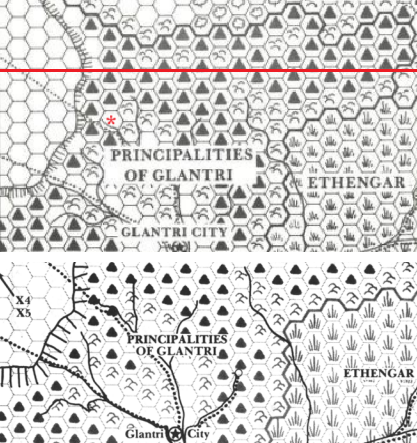
The northern trade route did not appear in GAZ3 "The Principalities of Glantri", possibly because it was not as well traveled. (Note also the blank hex in the map from X11 "Saga of the Shadow Lord", indicated by a red asterisk).
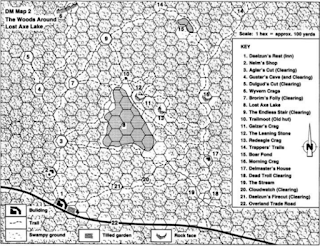
The map from CM8 "The Woods Around Lost Axe Lake" covers a small area (about 2000 x 3000 yards, less than 2 square miles). A standard 8 mile hex contains 55.4 square miles, so if it were not for the trade road, the map could really be situated anywhere.
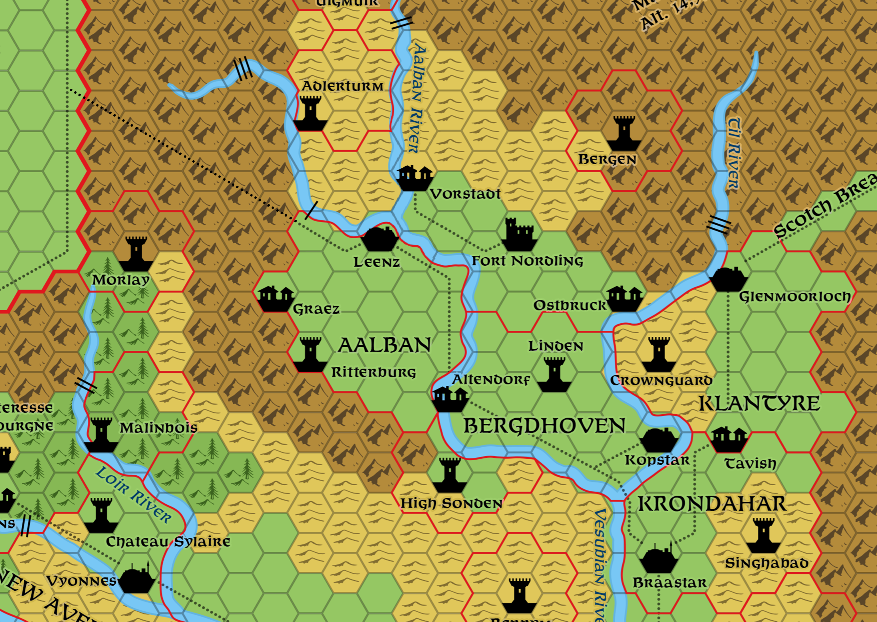
By extending the road from Leenz through the mountains to join the main trade road going north, we create a fitting location for Daelzun's Rest and "The Woods Around Lost Axe Lake", perhaps halfway along this route (I've added a dotted line to Thorfinn's latest map):
CM8 states that the area around Daelzun's Rest was ruled by a Baron Elktazar some 300 years earlier (prior to the formation of the Principalities of Glantri in 858 AC). His large realm contained "vast forests, rocky crags, and small farms, a loyal land under the Baronís even justice in a land of many small baronies and landholdings."
The northern Vesubian river valley (encompassing modern day Aalban and Bergdhoven) could represent Baron Elktazar's domain (there might have been greater forested areas, which were cleared to create more farmland).
CM8 also states that the Baron reigned from Moonkeep "a many-towered fortress atop a rocky crag (it is up to the DM to decide if Moonkeep has vanished entirely, is an explorable - i.e., dungeon - ruin, or still exists, perhaps under a different name, as an inhabited stronghold)." Perhaps Fort Nordling is the 300+ year old Moonkeep?
Lastly, the presence of a clerical sect doesn't bother me too much, since the module takes place on the fringes of Glantri, and it could always be a secret sect/cult.
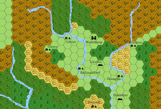
Continuing this line of thought, I flipped open my copy of "Dragonlord of Mystara" (1994) by Thorarinn Gunnarsson. The book is set in AC 500 (200 years before the rule of Baron Elktazar).
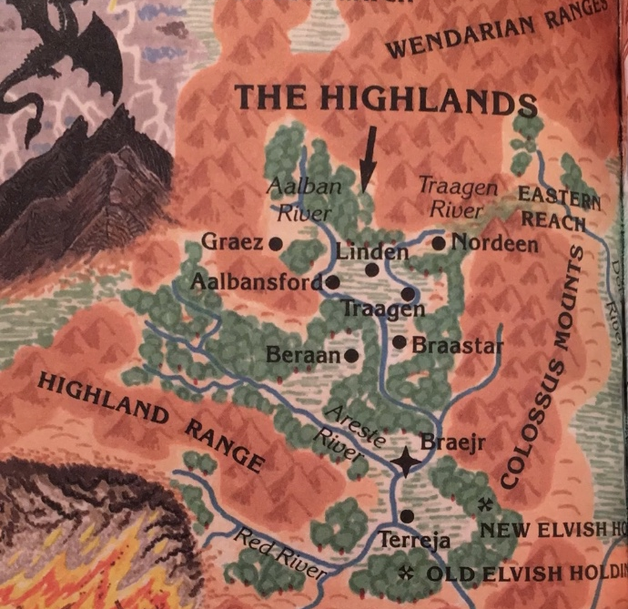
Key: Aalbansford = Altendorf; Beraan = Berrym; Braastar (unchanged); Braejr = Glantri CIty; Graez (unchanged); Linden (unchanged); Nordeen = Glenmoorloch; Terreja = Erendyl; Traajen = Kopstar
Locations that don't appear on the map from "Dragonlord of Mystara" include the town of Leenz in Northern Aalban, Fort Nordling, and the villages of Vorstadt and Ostbruck. The northern portion of the Aalban river valley is depicted as heavily forested, fitting the description of Baron Elktazar's land of ""vast forests, rocky crags, and small farms".
A map of "The Highlands" in AC 700 could include the "many-towered fortress" of Moonkeep in the location of Fort Nordling, and a village in the location of the town of Leenz (along with the trade route over the mountains to the northwest). Lands held by the House of Lindon would represent the southern boundary of Baron Elkatazar's lands.
Those 1 mile hex maps are gorgeous, although I don't think I'd have enough time to work on a comprehensive map of the region circa AC 700 in the time I've got to complete my submission.
In the meantime, I mocked up a draft on the free version of hexographer:
