
The Duke's Road Pass Trail Map
by RobinIn the fashion as I did earlier Trail Maps through the Broken Lands this is the thirdof a series of Four Trail Maps based in Karameikos.
I used all canon and several fanon sources detailing this. As according the discussions and faint canon descriptions I placed Highdell here and Not NW of Threshold. That region is Sir Reynald, as per Dungeon Adventure. So I broke and seperated some fanon to accomodate both these locations more detail.
In Karameikos there are officially four passes over the Northern Mountains (Black Peak, and Altan Tepes) leading into Darokin or Ylaruam
These are the Dread Pass Trail, the Smuggler's Pass, The Duke's Road Pass and the Castellan/Yebedeska Trail
There is only information on this map as registered by those walking there.
The following italic informative text is enscribed on the back of this map,
This map can be bought from any offical location along the way, in Kelvin, Specularum, Thyatis city, Ylaruam City and all Darokin cities for the price of
Cost 35 Crona (GP) to 55 GP depending on seller/trade.
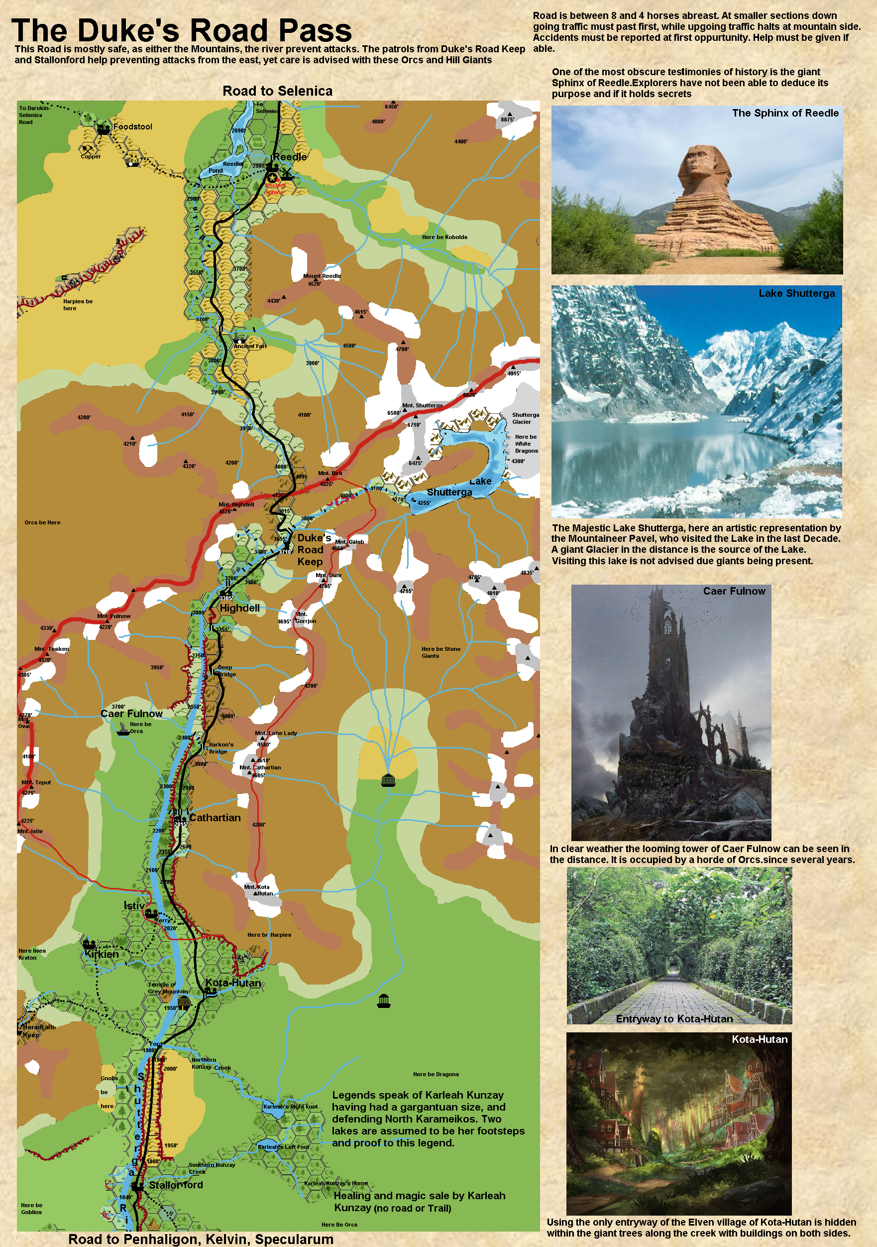
This is the latest edition (1000AC) of the Duke's Road Pass.
It explains the region between Stallonford in Karameikos and Reedle in Darokin.
The road begins at 1845' altitude in Stallonford.
The village has a silver class Inn; the Hungry Halfling, owned by Janu, an old friendly halfling. Dalmarak the Dwarf is the local smith, for arms, and armor, as well as any other metal crafts rquired. Going north two miles, then goes up the cliffs north of Stallonford to 1880'. over a 200 yards steep climb of 35' high.
The road follow these hills over about 8 miles, climbing slowly from 1880' to 1910' altitude then goes slightly down to the Northern Kunzay Creek where it crossed a minor ford.
Here is also a major ford over the Shutterga at 1900' towards Kirkien and Haradraith Keep. This ford is generally 2 to 3 feet deep, yet in spring and after thunderstorms may be impassable due incresed depth. Use the Istiv Ferry North in these cases. Beware There are Gnolls on the otherside.
The road continues 4 miles further north and diverts eastward from the river, circumventing the Grey Mountain.
Legends say this mountain was tossed here by a vile and powerfull sorcerer using some ancient spell of immense magnitude. There is now a temple of Ilsundal.
The road still slowly climbs through the Hills until it crosses a granite and marble adorned bridge over the Kota-Hutan creek at 2055' altitude. There is a small road going 300yards eastward into the forest covered village of Kota-Hutan itself. Kota-Kutan has a Silver Inn named Illasyael, where pries are average, quality is good. Materials bought here are however 50% more in cost and standard contruction time. Don't be hasty, it will be fully ifgnored, and may even slow the process more.
From Kota-Hutan the road leaves the hills coming into a grassland aside the Shutterga at 2000' altitude. The road is just 5 feet above the river, and with seasonal flooding this grassland may be flooded 1 to 4 feet deep up to the road.
After 5 miles along the river Mount Kota-Hutan in the east comes closer and with a sharp cliff decreases the width of available space between the river and the mountain. Beware. The grassland area as well as the hilly area here is often under attack by Harpies. At least have all guards be prepared accordingly (Plugged Ears, or silence spells, and missile weapons).
Here at an altitude of 2020' is a medium ferry over the Shutterga River towards Istiv and Kirkien (5sp/wheel/leg. 25.000cn max ferry load)
From the Isiv Ferry the road continues 5 miles north through forested hills a few hundred yards wide on eitherside. At an altitude of 2350' the road goes up the mountain the edge of the cliff in to an alpine meadow. this is a very steep cliff. The local dwarves have created a chain link system in the centre of the road to prevent sudden accidents and help the draft animals in their duty. The chain is almost 2 miles long and is controlled by a mechanism at the top altitude of 2680'. When the chain is in action wait until the wagons meet at an end. The meadows and 8 horses abreast road enable save passage there. Be careful. Use only the hooks every 100 feet on the chain, remove any caught debris mud and snow from the chains and chain guley, lead the wagons over the chain and attach hooks to centre front axle of wagon going up, or centre back axle when going down. Do not attach more than 2 wagons, or a heavier total load than 80.000 cn. The chain helps yet accidents still can happen. disembark from any wagon, controll animals from aside. Often local dwarves are willing to help for a flat fee of 5 gp/wagon(no refund on accidents)
Riders can climb this climb with some difficulty, having a riding skill certainly helps.
From there it is only 2 miles towards Cathartian at 2815' altitude with the river below at 2200' altitude.
Cathartian Holds a Caravanserai for 30 wagons, and has a Silver Inn Called "Mediocracy" by Julliard Tamaskin a Traladaran former adventurer and a Copper Tavern (Named "Watering hole") which can (and often does) harbour 500 people. The sevices are meager at best, and it is rumoured the Iron Ring takes a charge in the profits. Guards from Duke's Keep have a small contingement (10) here in case of fights and other irregularities.
From Cathartian there is about a mile farmlands until crossing a 10 horses abreast ancient Dwarven bridge over a creek with rapids below and a warterfall east from Mount Cathartian.
After this Dwarven Bridge the road continues another 5 miles slowly going up.
The nest point is another Dwarven bridge of the same features. at an altitude of 3325' while the cliff opens up due a creek passing and at a mile NW enters the Shutterga at 2400' altitude. There are some minor fisher trails through this forested and Alpine area towards the river. In summer Cathartian Youngsters frollick around this bridge (called Harkon's Bridge). From Harkon's Bridge in the far west Caer Fulnow can be seen in clear weather. many Orcs of the Severed Goose tribe live there.
After Harkon's bridge the road goes into the mountains proper for 6 miles climbing to 3720' onto yet another Dwarven Bridge (now 5 horses abreast) called Deep Bridge. The creek passes at least 200 yards below this bridge.
A 700 yards further you see the road comes within a 100 yard of the edge enabling a view in the Shutterga valley dow to 2750' where the river rushes by. Last year Prolaps the Dwarf and Enikin Tarsa fell off this cliff plunging into the Shutterga. The water deposited them 5 miles south at the feet of the Creek at Harkon's Bridge. They did survive...barely. So be aware.
From the Deep Bridge the road curves east back into the mountain maintaining an average altitude of 3400'
After 3 miles a valley with another creek cuts the way, sloping half a mile north and a 100 feet down, the road enters a 400 yard long 6 horses abreast Dwarven Bridge which enters the opposite mountain there.
Within the mountain a decending dwarven tunnel has been carved, curving slightly, extending just over 1.2 miles ending at 3350' on the otherside.
The road continues to Highdell for another mile.
Highdell at 3305' altitude is a roadside village stretching for almost 300 yards along the road. Most buildings are placed against the mountain, and some minor farming is done on the downsloping hills towards the Shutterga at 3200' altitude. The region has been several times under attack by Black Peak Stone Giants as well as Frost Giants from the Shutterga Glacier. Some buildings thus reflect damages accordingly.
The Pick & shovel is a silver Inn patronned by Sharrlaya Dancingblade with silver standard prices. There is a Chapel to Halav, a fortified keep-like tower, and a nearby Dwarven cave shrine to Kagyar for Dwarves. The 900 residents of Highdell are a mix of humans and dwarves. A small selection of gnomes and hin make up the numbers. The Highdell Market (at Lunadain and Soladain only), a dwarven maintained smithy, an alchemist and a warehouse make this a good frontier town. The Keep-like tower is holding a small contigment of soldiers as the nearby Duke's Road Keep provides firther defensive measures. 244 troops (the able-bodied militia men and women/dwarves and human together from the village are trained once a month for 3 days) use this tower in the center of the village as a means to defend the village.
At river level there is a wooden bridg4 used by farmers to acces the fertile lands on the otherside of the river.
From Highdell you climb again slowly for 4.5 miles till you reach the Duke's Road Keep. From here all patrolls and defensces are regulated. This structure is as being military not regularly accesible to passinf travellers. There is a prison for misdemeanors, yet any imprisonment deemed worthy over 1 week is send in cage to Specularum or Kelvin. The Keep is at 3710' altitude and the river passes by below at 3655'.
A mile north of the Keep is a Karameikan-Darokin mutual construction (with dwarven aid) of a 8 horses abreast stone bridge over the Shutterga. The 300 yards long bridge slowly climbs and enable easy acces to the Road up the mountain.
Beyond the bridge you are at 3700' altitude and the curving road enables the steep long climb in an acceptable fashion up the mountain. the whole road towards the top is 4.5 miles and goes from 3710' to 4135' altitude. The highest location holds a Darokin-Karameikan Borderstone with rough distances towards major settlements marked on it.
From here the road no longer curves wildly but enters a sleep long slope on the otherside of the mountain over alpine meadows after 2 miles of mountain. After 11 miles the alpine Meadows give way to Forested creeks and hills. There are some ruins of an ancient fort visible half a mile east from a simple stone 4 horses abreast bridge.
Another 10 miles goes to a similar 5 horses abreast stone bridge. You see mount Reedle in the east.
3 miles north of this bridge the Reedler Sphinx is visible and another mile gives acces to Reedle itself.
Most of the caravans that travel through Reedle are too large to stay in the village proper. Instead, they camp outside the village in partially fortified campgrounds surrounded by wooden palisades and earthen ramparts. The gatehouse is manned at all times by 2 members of the Watch, often assisted by trusted adventurers who earn a few gold pieces per week for their troubles.
Reedle has the Golden Goose Public House, which is a Copper Tavern.The Dancing Hobgoblin is a copper Inn. The High Creek Brewery is a location to acquire fine apple cider liked by Elves(Helpful in trading communications). The DDC, and House Hallonica are active in this village. Offensive and intrusive spellcasting is illegal.
Merchants and travellers beware , this map does not contain all information