
Thoughts about Ennaej
by Robin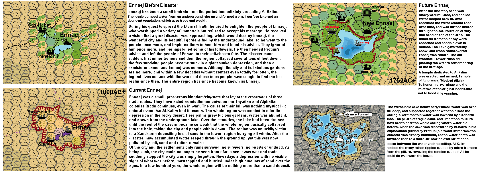
Using the discussion above
For those unknown;Ennaej is an Obscure location In Ylaruam Known World Mystara, and is only cannonnically found on the cover of Gazetteer 2 (see here; upload.wikimedia.org/wikipedia… above the female dancer)
i created the region described using Geoff Gander's excellent description.
Quote Geoff Gander; Now then, how big do we think Ennaej was? Personally, I think the town sat in an oasis of one 8-mile hex, and the underground lake may have had enough water in it to irrigate another one or two hexes. The town may have controlled one of two villages, as well. (the rest of his text is used in the text of the maps above)
The only difference I did make was not making Ennaej a part of the escarpment which collapsed, but placed in a depression left over by the Mogreth Era Ice Tidalwave which shaped the whole Ylaruam region.
I did prefer this mostly due the Icewave being too large and too strong to enable such a section remaining, while a depression created by sinking water directly after was more logical. Also fanon locations of Nithian mining and the Ruins of Mogreth Gathol on the edge of the escarpment made this solution better.
This version also does best fit with the works of Simone Neri on the Atlan Tepes Mountains
Also if it had been a collapsing escarpment segment it should be closer an hence obstructing the forming of Nithia as shaped by the various fanon. And if it had been a seperate escarpment segment, even if it had been collapse , it would leave begind remnants visible from a distance. As Ennaej was placed only a 16 miles away from the Oasis of Sulba, such remnants would still give a prominent clue where Ennaej is to be found. The way I resolved it with a sinking area and covering with sand, even being within a single mile from the collapsed area , would not reveal the area, the ruins or else.
It is now more than possible people could travel through this region along the edges of the depression without becoming aware it has been a fertile area known to be the Emirate of Ennaej, only seeing a mostly sandfilled depression best not traverse through due "sinking in sand dangers".
20-07- 2021 Added the underground cave and the 1742+ map of the region where over time the depression filled with sand was slowly refilled by water, becoming a very fertile oasis, giving new life to Ennaej.
This cave was collapsed mostly, the entrance tunnel giving way to an inundated area underneath the collapsed ceiling. Over time this would become filled with fine muck, sand and further collapsed material, forcing the water to rise, penetrating the surface after centuries. in 1000AC only the most northern tunnels are still accessible, yet reveal no interest. The tunnel may be a hiding place for creatures like snakes and bats.