
Relief map issues +/- drainage & rooftops
by Kilr KowalskiI was thinking about rooftop and underground means of travel through Specularum.
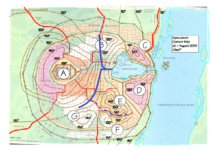
I definitely think that on the whole open sewers in the streets etc esp in the older parts of the city is the right "look" for the place. However I was also thinking about clandestine pathways through the city. On that score I looked through the relief map of the city and noted some really important buildings are now in regions which are gulleys and low points between the hills. Of particular note are
-South end: granaries, magician's guildhall and library
-Church of Traladara, The district admistration buildings, the temple of chardastes and library, all of the street of dreams
-north end: northern westron alley
I'm wondering if we can solve the problem of flooding in these buildings with some drains under some of these areas. The problem being that these areas elevations are ~110-120' and the water level is 90' when not in flood. but if we can presume a 5' high passage 15' below the surface these drains would still have a gentle grade into the bay. They would also work like trunk sewers and form a basis for some clandestine transit throughout the city without turning Specularum into one great big mega-dungeon.
I don't know if it would have been a priority of the thyatian rulers to have put one of these drains under the old town or the nest
but if there ever was a flood and cholera this might be a good motivator for "public health reasons"
in any case I have jotted in these suggestions to the relief map (the dotted line is if there was a corresponding Nest "branch")
EDIT: going through some old notes you guys made
Ville Lahde wrote:2) The Great Irrigation Channel and the Suicide of the Guardians (see "Elder Guardians" in the scenario)We actually discussed this earlier in the other thread. The notion is that in order to combat the droughts an irrigation channel was dug
in order to channel water to the northern fields. The preferred route would be (due to dramatic reasons in the scenario, and in keeping
with the contour-map of Specularum): Westward from the Hightower - Turn north towards Lesser Merchant District - Turn
northwestish towards present-day FQ in the middle of the Lesser Merchant District. Thus the marketplace where the Elder Guardians
appear would fit smack in the middle of the northern marketplace.
Since the scenario has the bridge and the channel also as a social class division line, we might place this event after the migrations of 750
AC, and the two northeastern hills might be (fittingly) the stronghold of the Radus, and the economic seat of power in the city. Digging the
channel itself might be one of the great PR stunts of the ascendant Radus after 612? (It would also fit the fact that the channel was
dug to combat the problem of dry wells.)EDIT: The channel was obviously filled later, but I have no idea as of the date and reason. Or: perhaps it was done during Stefan's construction
projects - Foreign Quarter too over many of the older fields, and the northern areas were devoted to the Hunting Guild? So intensive irrigation
was no longer needed.
Maybe it was filled or just covered over. In any case, the rubbish & detritus in a filled channel may have been easier to excavate at a later date, especially seeing the path is fairly similar.
Finally: if I get the time i will look at the district maps in regard to rooftop travel, some regions of bricktop, the north end, southend
and merchant quarters, and almost all of the old quarter and the nest could have secret but well worn rooftop "roads" for the city's thieves.