
The Great Crater and Underneath
by RobinI created the following maps.
The Information I used to create them is from some canon and most from Andrew Theissen
As I couldn't find complete maps about these underground regions, I created them according Andrew's Notes.
I also used some of the map by Sean Meaney.
Although I have edited these maps by normal geological effects of an impact by meteor,
and by the well done illustration of explorers at the crater's rim in the AD&D Glantrian gazetteer.... revealing that the rim and crater are very steep. See also tiny picture here
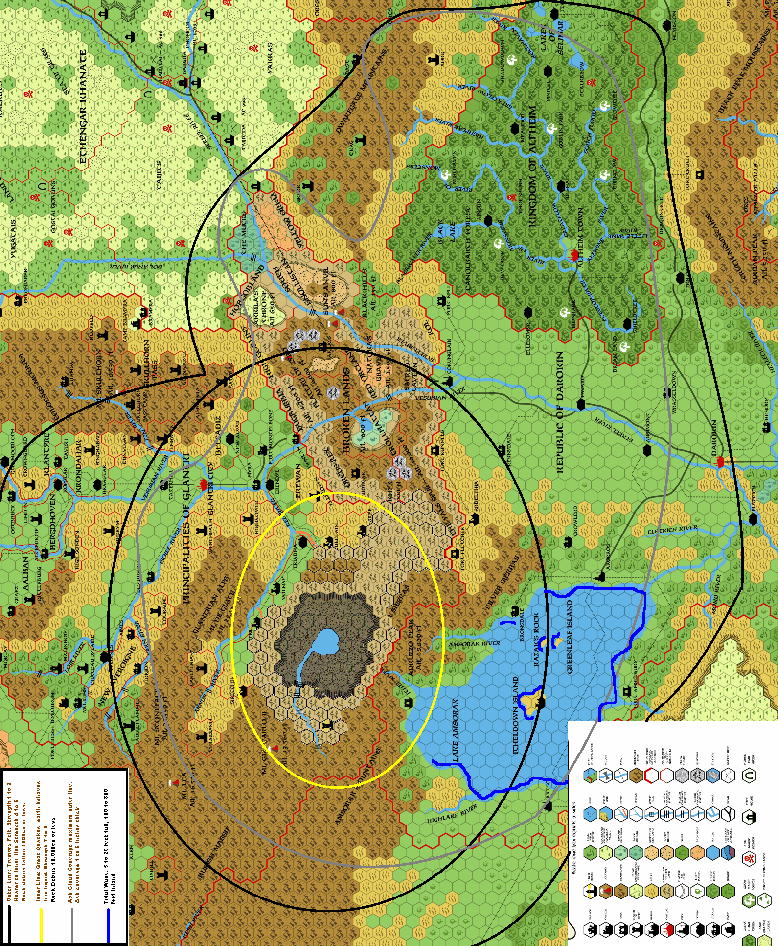
In the Wrath of the Immortals a great Meteor descended from the sky destroying a part of the Silver Sierras on Mystara. This was between Glantri and Darokin, and created a new and extended area of Broken Lands.
But nothing was explained of the impact itself.
This map is a feeble attempt to clarify this. Remember, due to the Skyshield of Mystara, the meteor was lessened in impact strength, otherwise it would have been a Global destroyer.
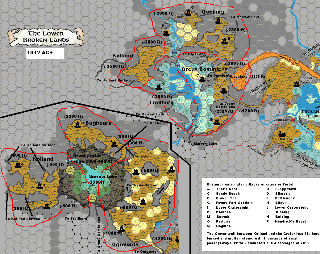
The Lower Broken Lands 1012 AC
These are the Eastern Broken Lands (the original) after the Great meteor impacted the area. Clearly can be seen the tunnels leading west towards the great crater and thus the western Broken Lands.The red blocks are closed gates (underground blockages by fortresses). originally these were humanoids, but since the shadow elves discovered and reconquered aengmor...aka oenkmar, they have chased most humanoids out of the areas north and west of the lava rivers.
The Kolgate and Kol-edge gate are completely sealed of by Shadowelven stonemagic.
Bugburbia, High Gobliny, Hobgobland, Yellow Orkia and Kol are fully under control by Shadow Elves. They have closed off most passages crossing the lavarivers.
Orcus Rex, Is still mostly under control by the different species of Orcs, hence the only castle still not destroyed is within that region, as is Trollhattan, mostly an uninteresting fungalswamp, but many trolls left the area and moved west. Troll Gate and the gate to Orcus Rex are heavily guarded.
Ogremoor and Redorcland are actually a buffer zone, and controlled by neither race. However, both races keep their patrols.
The Shadow Elves have not discovered the Humanoids Sacred Cavern. and some powerful humanoids still recide there.This map was adjusted from a map by Thorfinn Tait based upon Canon matter concerning Mystara.
The Western Broken Lands 1012 AC
This is my map of the caves being created by the great meteor, in and under the Great Crater.
generated by the impact, of the meteor.In effect one of the cells of the megalith (the planet see my blog ; here and here) completely collapsed, the sides of stone melted, and fused everything together. some parts were pushed up, to the side or was compressed down. Together it created a completely new environment on Mystara.
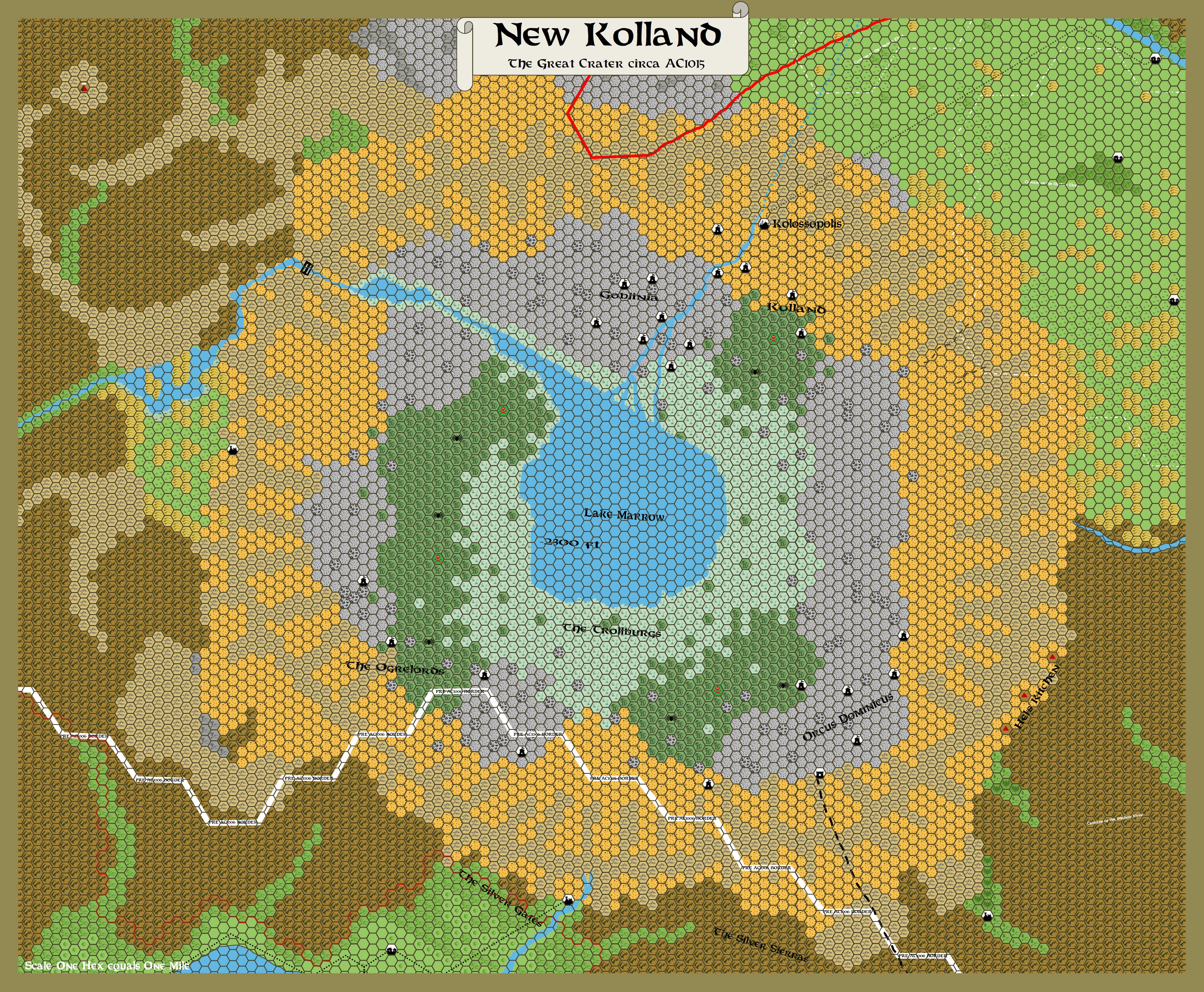
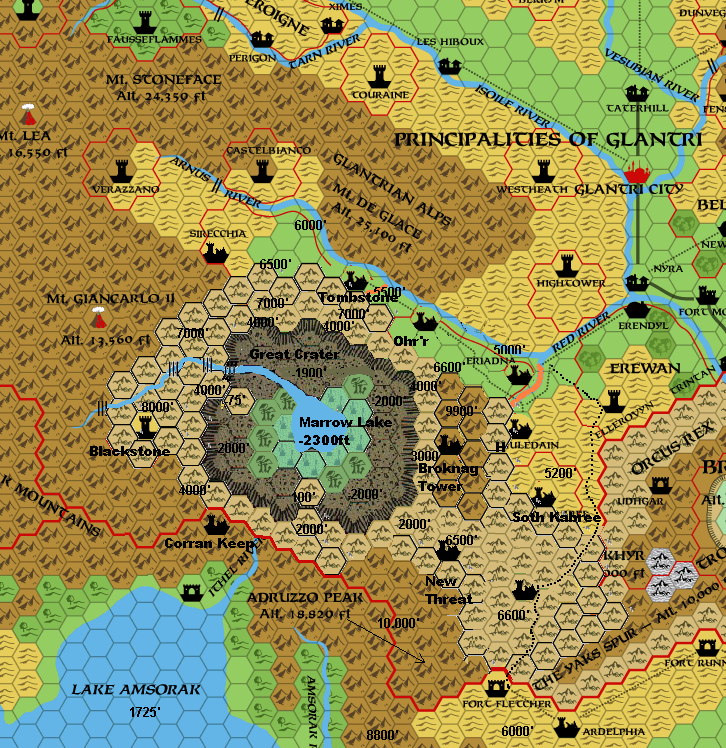
The Great Crater of the Western Broken Lands on Mystara now with better altitudes.1015 AC+; The Great Crater (edges 4000 feet high, followed with a bumped hill of 7000', slowly decreasing to the areas around) with Marrow Lakedeep down surfaced at -2300 feet, emptying in deeper caves.
Two collapsed edges (West and south) give –more or less—easy access to the crater’s bottom.
The orange rivers are dried up rivers. These may still be flooded in the wet seasons (Spring and Autumn)
The unamed Ruins in the South are the former Camp Huledain, now renamed Celedyl. The area bolsters new growth of plants by unknown sources, and will soon be overgrown hills instead of Broken lands. How far this effect will stretch is unknown.
As these are to be intended to be used in another chapter of the Monster Manual, I need some of your input.
The maps are based on some of the Canon and some Fanon found here on the Piazza.
The text I compiled from different sources sofar is as follows;
The Great Crater 1007 AC +
1006 AC Summer The Master of the Desert Nomads has been defeated. His forces retreat into Sind and tighten their grip on that unfortunate country. Atzanteotl, disgusted by the Desert Nomads’ inability to get the job done, washes his hands of the whole affair. As a final defiant gesture, the Master formally curses those who have defeated him.
To everyone’s surprise, the curse has an immediate and deadly effect. Only a few days later, an enormous meteor (a remnant from the former 5th planet) smashes through the skyshield and slams into Northern Darokin/Southern Glantri, the Silver Sierras. The impact destroys an entire range of mountains, creating a crater dozens of miles in diameter. The resulting earthquake knocks down buildings as far south as Akesoli, and can be felt in Glantri and Darokin City in Glantri, the Principalities of Blackstone and Caurenze are devastated, as is most of Darokin north of Lake Amsorak. The cloud rising from the impact is larger than some countries. Stretched by the last western winds in the season, the cloud covers all of southern Glantri and Northern Darokin out as Fareast as the middle of Alfheim. The immediate loss of life is tragic, but Glantri Survives. However, the impenetrable cloud stays in the air for days, blocking out the sun. When it finally starts to settle, ash covers everything, killing plants and fouling drinking water. Together the cloud and the ash have a catastrophic result on both countries, ruining the harvest and threatening famine for the upcoming winter. Popular opinion in Glantri credits the attack to Alphatia; the Glantrians vow to make the Alphatians pay.
This event surprises the Master as much as it does everyone else. The immortal to blame is not Loki (bozdogan) nor Atzanteotl, who know better than to risk the punishments sure to follow such a blatant act of direct Immortal interference once the immortal Council of Intrusion tracks down the perpetrators. Instead, it is Alphaks, whose love of big explosions and mass destruction had finally got the better of him. He diverted the meteor from its regular path and aimed it at Darokin; the only reason it did not do even more damage was his desire to make the Glantrians (descendants, like the Alphatians, of some of his ex-followers) suffers as much as possible. This crater its debris was scattered over an area of 500,000 million square kilometers and rock fragments ejected over 497 miles away. The ash colored the sky orange for weeks up to 4000 miles away, and had great impact on weather patterns for the coming year.
The Meteor approached from the North West to Western (NW to W) side in a relatively angle of 48ş, creating a directional force on impact all around, but primarily Eastwards, pushing the area up and eastward. Thus enlarging the Broken Lands, and destroying the area in between.
The Glantrian Principalities Blackstone and Caurenze are devastated, as is most of the area north of Lake Amsorak. The cloud rising from the impact is larger than several countries. Stretched by the last western winds of the season, the cloud covers all of southern Glantri and Northern Darokin out as Far East as the middle of Alfheim. The immediately loss of life is tragic, however, the impenetrable clouds stays in the air for days, blocking out the sun. When it finally starts to settle, ash covers everything, killing plants and fouling water. Together the cloud and ash have a catastrophic result of crops of both Glantri and Darokin, ruining harvest and threatening famine for the upcoming seasons. Even the Elven hometrees seem to be –though slightly—affected, and are stalled in fruit and leave growth.
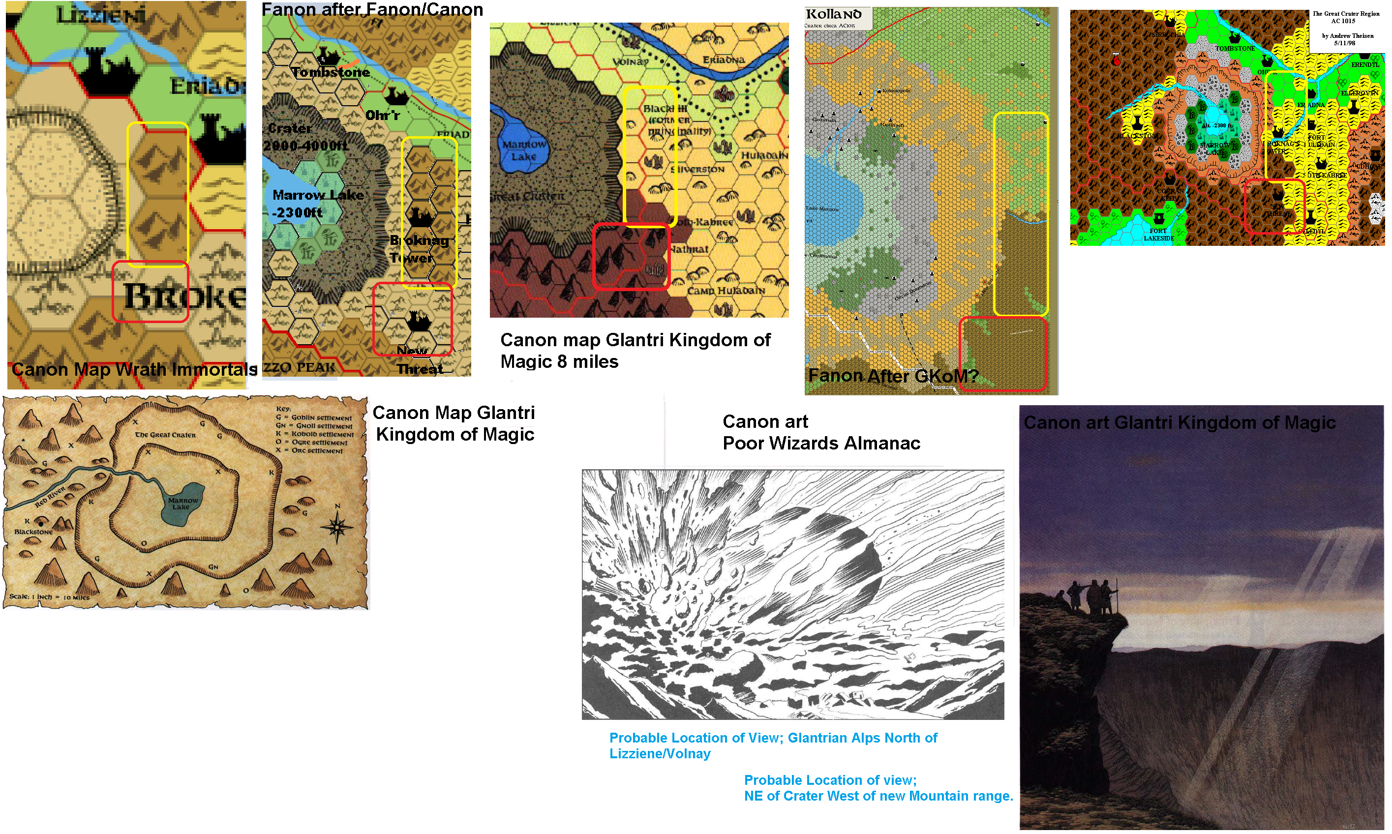
As a research tool for the creation of the 1 mile hex map of the broken lands, this is a combination of all visual sources I could find of the Great Crater that cannonically dropped down on Mystara.
Important notice is the fanon 1 mile map showing NO mountain ridge (in the Yellow lines) on the NE, while canonically it does,
Also the canonicallly broken lands area in the SE is mountain in the 1 mile map (red lined)
Also as looking at the art of the Crater, the edges are much, much sharper, i.e, cliff-like than the 1 mile hex map presumes to be,
My opinion as thus is that the 1 mile map (though very very nicely made) has its major flaws, though also its major charm.
As for the creation of the 1 mile hex map of the Broken Lands I try to stay as close as canon as possible, but I surely want to add as much fanon too.
The canon sources are from GAZ3-TSR2511-AD&D2-Mystara-Glantri Kingdom of Magic and TSR 1082 - Wrath of the Immortals.
The fanon map left from Pandius was probably created from the 8 mile hexmap in GAZ3-TSR2511-AD&D2-Mystara-Glantri Kingdom of Magic
The 8 mile hex map on the right is created by myself several years ago. It is created from the 24 mile hexmap from TSR 1082 - Wrath of the Immortals, the 1 mile hexmap from GAZ3-TSR2511-AD&D2-Mystara-Glantri Kingdom of Magic, trying to compensate the differences. The 1 mile fanonmap, I was unaware of at that moment.
The Art from Gaz 3 reveals the craters steep angles, while the art from the Poor wizard almanac reveals the angle the meteor slammed into ..This must have been as it was seen from the north looking south. This one also shows the angle of impact, anfd the logical creation of the Eastern New mountains (where silverstone existed) due pushing up and forward all matter.