
After finally having had a chance to read the third novel in the Quest Triad, by Douglas Niles, I have taken some time to re-think my approach to adapting the Lands of Karawenn, the setting from those novels to Mystara's Norwold.
Lands of Karawenn
by HåvardTHE MAP
The first problem encountered was the map. Some of the criticism received earlier was that my previous maps imposed too many changes in the geographical features of the CM1 map. With my new attempt I have decided to tilt the Karawenn Map slightly and move the region to the western edge of the Great Bay as suggested by Old Dog. One advantage this has is that it allowed me to align the Trollheight Mountains with the Jotunheimr Hills:
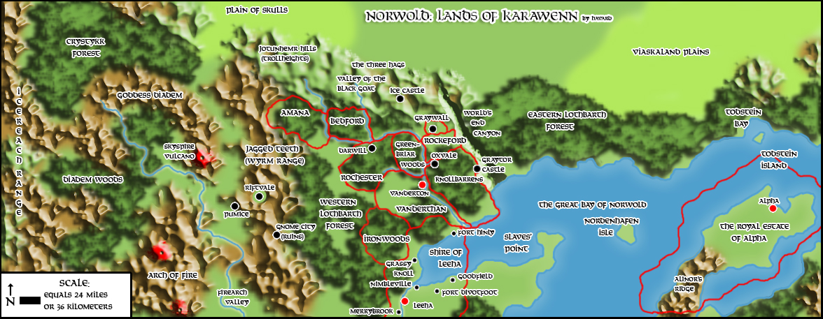
Not counting settlements, the only alterations on the geographical features of the canon maps are the River Tanyv (Running through the Karawenn Region) and the World's End Canyon. I'm reducing the latter to a mere canyon that may have some magical effects to the somewhat bizarre "End of the World" phenomena described in the books.
Map Locations
• Vanderthan - The southernmost of the Realm of Karawenn. Vanderton is its capital.
• Vanderton - The capital of Vanderthan
• Rochester - The Realm west of the Greenbriar Forest, north of Vanderthan and east of Bedford. Home of the Blue Gorgon.
• Bedford - The Realm west of Rochester. Famous for its weavers. Once plagued by Goblins.
• Rockeford - A Duchy north of the Knollbarrens. Secretly allied with Trolls against Vanderthan. Home of the Bull Troll.
• Trollheights - The hills north of Karawenn. They are home to Dwarves, Trolls, Yetis and other strange creatures.
• Knollbarrens - A hilly region in the eastern part of Vanderthan.
• Oxvale - A farming village in the Knollbarrens. Its inhabitants, known as Darymen was once known for their courage and heroism during the Trollwars.
• Graywall - The largest dwarven settlement in the region.
• Graytor, Castle - A legendary castle, built by Giants who once lived in Karawenn, now in ruins on the edge of the End of the World Canyon. It is where the artefact known as the Source Lodestone is located.
• Tannyv River - The river running through Karawenn.
• Tannyvheights - area south of the Greenbriar Forest
• Ice Castle - Home of the Yetis.
• The Three Hags - Rocky formations resembling three old women.
• Greenbriar Forest - A woodland area which is home to a community of Shiye elves under the rulership of the Kippican Clan.
• Vale of Strength - magical area, created by the elves. Now the home of Elkhorn and his Sprites and other Fey companions. Located south of the Knollbarrens.
• Glade of Wisdom - magical area, created by the elves. Now a home to Sir Ira Hsiao and possibly others of his kind. Located in the Knollbarrens.
• The End of the World - A vast canyon creating a natural eastern border of Karawenn.
• Amana - The lands of Earl Terrence. Home of the Black Stag.
• Icepeak Mountains - mountains north of Amana.
• Riftvale: A valley which is home to Fey, Fauns, Centaurs and Gnomes. It has recently become a place of refuge from those fleeing from the dragon Xtan.
• The Gnome City: A Ruined Gnome settlement, destroyed by the dragon Xtan.
• Skyspire: A volcano and the lair of the red dragon Xtan.
• Darwill: The capital of Rochester
• Pumice: A dwarven settlement. Its leader is Dargan Greataxe.