
Karameikos: Kingdom of Adventure Art Compilation
by RobinThis compilation of pieces of art from the Karameikos Kingdom of Adventure by TSR/WOC is only made to resarch areas of interest in my mapping process.
The original artists are; Daniel Frazier, Eric Hotz, John and Laura Lakey, Walter Valez
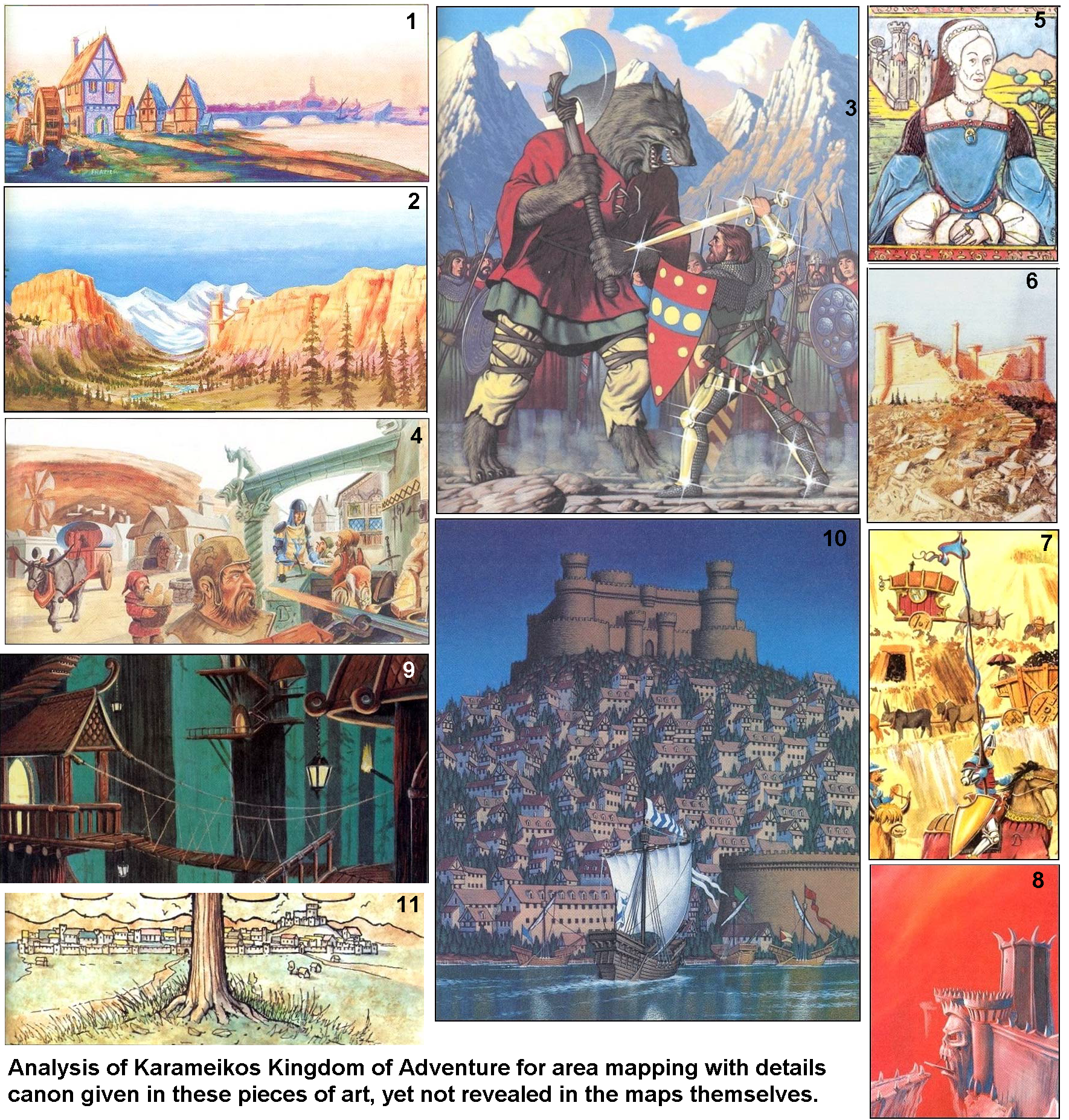
1=Location Analysis. Threshold
Source; Karameikos Kingdom of Adventure Main Book page 3
Accompanied description;
This watercolor shows a view of the town of Threshold from the northern tip of Fogor Isle, looking south into the city itself at dusk. The skyline is dominated by the bell tower of the town hallDetails Revealed; The town mill is a water mill, not a wind mill, the northern bridge (and hence the souther bridge as well) is of a simple multiarched stone construction not allowing ships to pass. The town hall is the highest sturcture, yet an equally high vague rectangular tower with an arched opening high up, cloaked by the evening mist is visible just outside the town walls on its western side
Conflicts; No description of such a tower is mentioned, nor revealed on the canon(as well as fanon) maps thus far. however, KKoA is placed in 1010AC, and a tower may have been created recently, and the open arch may even reveal it is not finished as of yet.
Resolving; I will mark the tower a mile west of the town using a tower symbol, labelling at under construction
2=Location Analysis. Cruth Lowlands
Source; Karameikos Kingdom of Adventure Main Book page 5
Accompanied description;
Most of Karameikos is wilderness, in particular the western portions where the desolate Cruth lowlands sprawl at the feet of the Black Peak Mountains. This empty, beautiful land is prowled by powerful monsters, including many ogres and giants. This region also serves as a home to wizards and other individuals who value their privacy.
Details revealed; White peaked mountains in the distance a waterflow bearing valley with steep sides not to far away from eachother and pines forested hills, as well as a tower on the westerns side of the eastern mountains.
Conflicts; The descriiption reveals this is the Crutch Lowlads, south of the Cruth Mountains in west Karameikos. Canonically there is no such detailed area.Following the X1 6 mile hex maps of the region there is only one such location possible which falls within the parameter of measurement derived from the rees as well as the tower.
Resolving; Following these all combined I require a tower (mage tower or keep) to be placed just south of the location where the Magos river leaves the mountains
3=Location Analysis. Battlefield of Halav
Source; Karameikos Kingdom of Adventure Main Book page 9
Accompanied description;
The Traladaran hero Halav, his magical bronze armor glowing, engages in a final battle with the leader of the Beast-Men. This piece is rendered in the New Karameikan style of art, stressing a realistic approach to portrayal and scene, as well as a focus on active subject matter.
Details revealed;A rocky underground with snowpeaked dark spure mountains on the background. These can be the mountain spires soth of Threshold east and west of the Waterolde/Widrush river; aka Mnt Ben Dalen, Mnt Zadreth and Mnt Chryspatitos. This would place the most prominent battle of Karameikos in the norther region of Highforge
Conflict; Even though the proximity of the mountains are close, the description as well as the art do not really reveall this eact imortant location. The traladarans would know and remember such a location over hundreds of years due its significance. Memorial structures would certainly be placed close to the battle field to remember the victory and the fallen
Resolving; Looking at the map thus far I compiled I create a barren rocky region south of Mnt Zadreth (so close to Threshold) where I can place a battlefield symbol as well as a monument symbol near it, which then will conform to the illustration canon
4=Location Analysis.Highforge/Eveskar Cave
Source; Karameikos Kingdom of Adventure Main Book page 23
Accompanied description;
The community of Highforge, a city where gnomes and dwarves predominate, is the starting point of the annual Gnome Caravan. These demihumans, who prefer living underground, built the major portions of the city primarily into the hills behind the “outer” city. The Gnome-King of Highforge, Dorfus Hilltopper, recognizes King Stefan’s sovereignty but holds ultimate power among the town’s inhabitants.
Details revealed; The location of Highforge is revealed as a single large Cave opening going into the hill with some structures in front of it, where trade takes place.
Conflicts; The current fan maps of the region or Eveskyr (Highforge main location) do not reveal such a cave.
Second; These fanon maps do not reveal such a large cave opening on neither map
Resolving; In my opinion and to stay as close as possible to the canon as well as the fanon is to place a settlement, however small next to a cave opening. The best location for this is in the 3 caves close to Eveskyr, enabling underground transit between the large Cave opening and the underground town of Eveskyr, and place a village there(naming it in Gnomish; "The Market".
The regional fanon map does not reveal a Cave and settlement on or close to eachother
So another solution would be to move Eveskyr 1 hex north against the caves or add a cave north off Eveskyr to enable this start location of the Yearly Caravan to be possible as canon describes
7=Location Analysis. Gnomish Caravan
Source; Karameikos Kingdom of Adventure Main Book page 104
Accompanied description;
The annual pilgrimage of the Gnome Caravan, bearing ore and finished goods, treks southward from Highforge into the human lands. The caravan leaves on the 1st of Thaumont each year, arriving in Mirros by the 11th of that month.
Details revealed; This caravan reveals Coal, a zigzag road over a mine
Conflict; I can't find a zigzag trail
Resolving; Adapting a single road away from Eveskar accordingly adding these details
5=Location Analysis. Marilenev Castle Ruins
Source; Karameikos Kingdom of Adventure Main Book page 79
Accompanied description;
Lady Magda Marilenev’s family perished in rebellion against Stefan, and she remains an outspoken critic of the king. Her portrait, rendered in the classic Traladaran style, shows the lady before the family manse, a deteriorating pile of stone.
Details revealed; This picture reveals a ruined castle must exist in the estate of Marilenev
Conflicts; Where is this located??
Resolving; not as of yet. It must be a really large castle, yet I can't determine its location as of yet within the Marilenev Estate...any suggestions???? I have on the east of the River and Specularum/Mirros a few unnamed Mansion ruins, and on the west of the river in the hills there are some unnamed/unidentified ruins, yet nether of these feel good. A castle should have some prominence,,,, yet Where!!!!
6=Location Analysis. Koriszegy Keep
Source; Karameikos Kingdom of Adventure Main Book page 86
Accompanied description;
Situated in western Karameikos, the toppled stonework of Koriszegy Keep remains shrouded in myth and legend to this day. Once the home of a powerful Traladaran family, it now is said to be haunted by the living dead.
Details revealed; A square/rectangle keep with 3 of 4 towerrs remaining, and a single chimney is all remaining of the main interior structure. There is no gate/gatehouse visible, if so existing it should be on the left wall(close to the Chimney) and be thus small to be obscured by the other wall from this direction. The place where the corner tower is collapsed. There is a 15 step stairway leading to this tower map of stepstones only a mere twice as wide and deep as each elevated step( estimated maximum 1feet high, 2 feet deep and wide) amongst many stones spread around. it ends lower at the hill where more stones are found. This stairway clearly was buld later.
Conflict; none
Resolving; It gives some more details of the structure other than those given in Gaz1. map wise it details a passage leading from the one of the corners, yet this is too large scale it is not required to detail on the map. I did however reveal a trail to the keep.
8=Location Analysis. Fort Doom
Source; Karameikos Kingdom of Adventure Main Book page 114
Accompanied description;
The main gate of Fort Doom, previous home of Ludwig von Hendriks, looms over the nearby town of Halag. When the fort fell to halfling invaders, they bypassed the gate house entirely, instead mining beneath the more vulnerable eastern wall.
Details revealed; The picture reveals a grotesk gate and tower in an extended wall (vaguely behind the gate also.) A Drawbridge in the facial gate leads over a crevasse to a cliff road. The description reveals that the gate is NOT on the eastern side. The red color is presumably made due the fires of war with the Halfling Invaders.
Conflict; The area is canonically described as a mere hill
Resolving; A cliff side must be added to the Keep...This is possible on the south as the east /north has a its own gate according DDA3-Eye of Traldar maps of the keep revealing a secondary gate. I already had two routes to the keep all i need to add is an escarpment
9=Location Analysis. Callarii Elven Settlements
Source Karameikos Kingdom of Adventure Main Book page 116
Accompanied description;
Elf lands are not defined by borders in the human fashion, but by the very presence of this ancient people. In the heart of the Radlebb Woods, the arboreal settlements of the elven peoples are a refuge for the lost and hungry.
Details revealed; The existence of Home trees and elven homes within these trees as well as bridges between them
Conflicts; None, just an addition
Resolving; I already Implied these using this information. However, not all elven homes are within the trees, most villages are ground bound.
10=Location Analysis.Mirros/Specularum
Source; Karameikos Kingdom of Adventure Main Book page 127
Accompanied description;
This depiction of Mirros was commissioned by the Thyatian Emperor. The assigned artist never made it west of Rugalov, and this piece of art tends to exaggerate on certain details (such as the size of King Stefan’s Castle and its height above the surrounding territory). However, it does successfully capture the feel of Karameikos as a wild, powerful, and strong nation.
Details revealed; Mirros/Specularum is build on the river on a hill
The city is more realistically revealed on page 99 at the bottom of the weapon shields; Here number 11
Conflicts; The water and the structures do not really align according the canon map of the city. The view is south so the water must be river, which means there should not be mountains on the background. The page 127 was already described as being faulty, so no high hill
Resolving; Forget the mountains(making these clouds), keep the hills low on which the citybwas build (already done)
10=Location Analysis.Castle of Three Suns
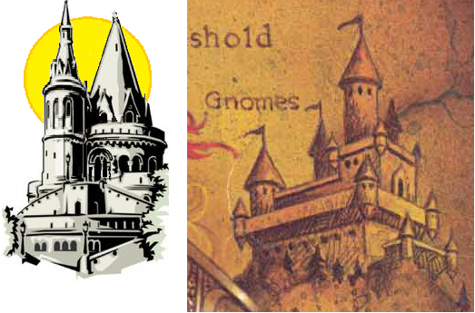
Source; Cover Gazetteer 1 Grand Duchy of Karameikos
Accompanied description;none
Details revealed; The castle of the Three Suns was right in front of our noses all the time. By knowledge from fan sites I collected this;
DJ Heinrich did use the Gazetteer in great detail to use as a base to write his Penhaligon Trilogy. The castle of Three Suns was based liiterally on the castle illustration on the cover of Gazetteer 1
. Here displayed with my earlier image revealing the 3 suns idea by breaking with two towers. In the cover illustration by Clyde Caldwell the second tower is visible just behind the castle.
Conflicts; none
Resolving; Done, using Sturms 3.2 mile map, yet I need to add an escarpment on the east side
Btw have you noticed that Milo Korrigan (picture page 90)resembles Harry Potter, and his uncle resembles Rubeus Hagrid?? Another example of movies used to depict Karameikan personality; Others were drawn from Soaps.,,yes soaps like; As the World Turns, Dallas, Dynasty, etc. ...and yes I viewed Soaps...I am not only nerdy and a freak but also a geek >
Btw I require some help and any suggestions are more than welcome (especially on the red text subject)