
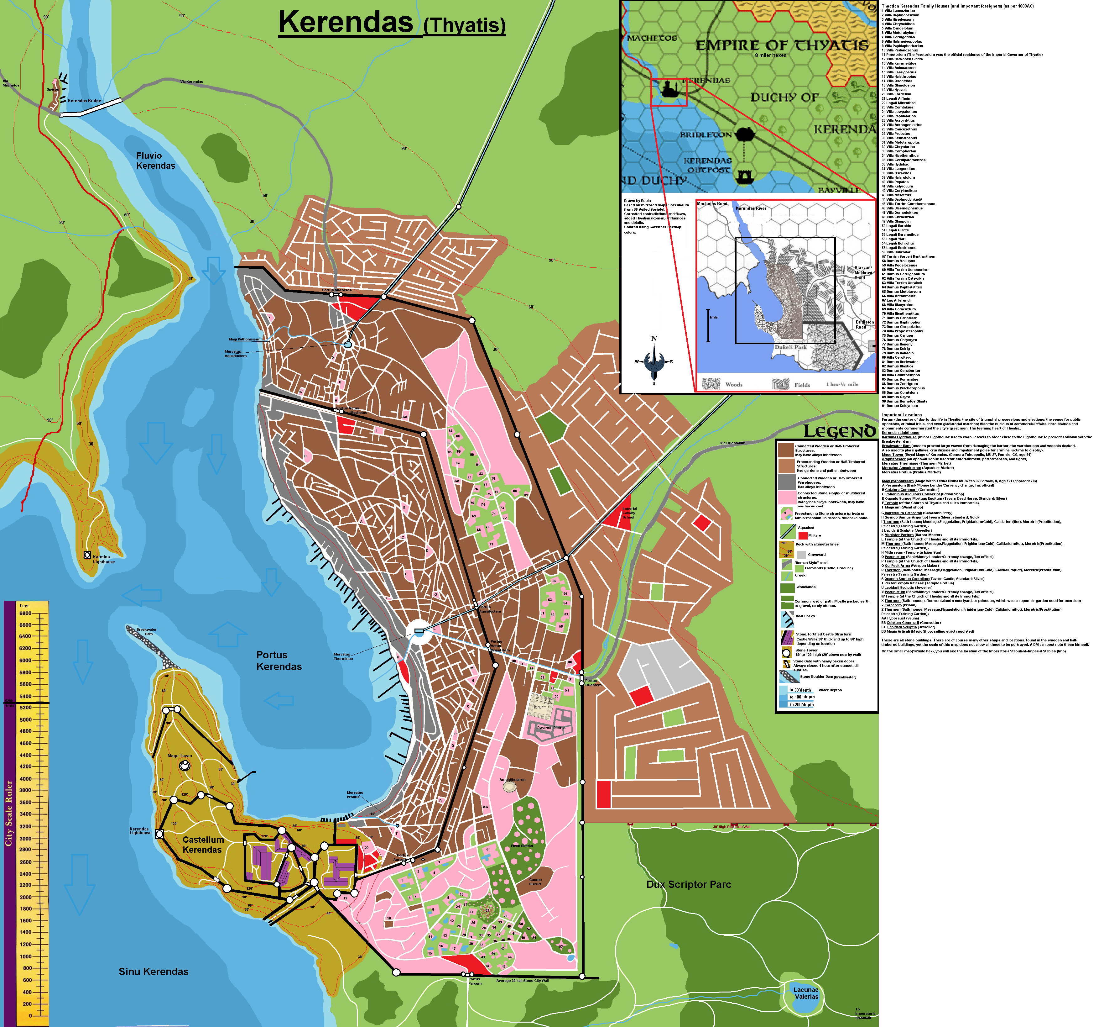
City of Kerendas
by RobinThis is the City of Kerendas from the Thyatis Duchy of Kerendas as per Gazetteer maps and Dawn of the emperors boxed set.
This city was unmapped thus far. As with my mapping of the city of Machetos, I use the map of Specularum as per B6 The Veiled Society Adventure myself.
Why?? because I found it a real pity, this map was shoved into the corner of oblivion due the Specularum remade map which since then became the map to refer to.
After some digging deeper into this mostly grey-scaled map on the inside cover of the adventure , I noticed the adventure itself has some serious differences between the 0,5 mile hex map and the main map. Especially in the 'New City" and the city walls. Also the main map did not use the settlements outside the city walls noticed on the tiny area map in the beginning of the adventure. The ruler to measure distances was even placed somewhere else.
So I mirrored the map, began imposing colors from the Gazetteer maps to define terrain. Made lines and walls clearer. Defining sorts of structures (Wood/Half-timbered, Stone, etc)
So now I had to readjust the differences, where I decided to take precedence over the larger scaled city map, and imposing the smaller scale where material was missing.
Doing so succesfully I imposed Thyatian structures as additions and Thyatian nomenclature (Latin). Adding some further detailing conforming to the terrain.
The map suddenly became beautiful, in my opinion instead the grey scaled version of the map as per Veiled Society.
Adding Thyatian family names (as per DDA1) and important location descriptions in Latin. The Map is now a useful source.
For more information read Dawn of the Emperors.
Dawn of the Emperors Players Handbook page 6 wrote:
The Kerendan Plains
The western region of mainland Thyatis is called the Kerendan Plains. This is the flattest, richest land in Thyatis. Here are the best farmlands and pastuage, well-watered by runoff from the Atlan Tepes Mountains. Many Caravans pass through, bound for Thyatis City and beyond.
This is the best horse breeding country in Thyatis. Kerendan horses are przed all over the continent, and Thyatian and Ylari horsebreeders keep up a fierce competition as they try to breed the world's most wondrous steeds. These plains are also the seat of Thyatis' cavalry. The city of Kerendas is home to the great Thyatian cavalry officers' training school (Note from me; One just outside the city, another nearby, between Kerendas and Bridleton, see picture below).
...
Kerendas is the area's largest city, a thriving seaport and trade city with a long distinguished military tradition. it is thought to be less decadent than the Imperial capital, and Kerendans pride themselves on being stronger, faster, and less dissapated than citizens of Thyatis City.
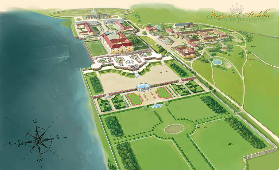
This wonderful map style picture is made by Abosz007, and perfectly details the Imperial Stables close to the Thyatian coast, between Kerendas and Bridleton. (only ignore the background lable of Pirates, and turn the compass 180 degrees )
I tried to incorporate all these aspects in the map using colors, labels and such.
13-05-2021 Added location of the Nearby Imperatoria Stabulant (Imperial Stables), after the works of Abosz007, with minor changes; turn the compas 180 degrees, remove the pirate label, adjust to Thyatian (Roman) time/lifestyle, the underwater area would be suitable for Seahorse training...A defensive and scouting subdivision of the Thyatian army holding Merrows and Soldiers using water breathing magic.
I really hope you like it, I love how the end result with the colors came out, yet I can still see the original map fromn hence this map came.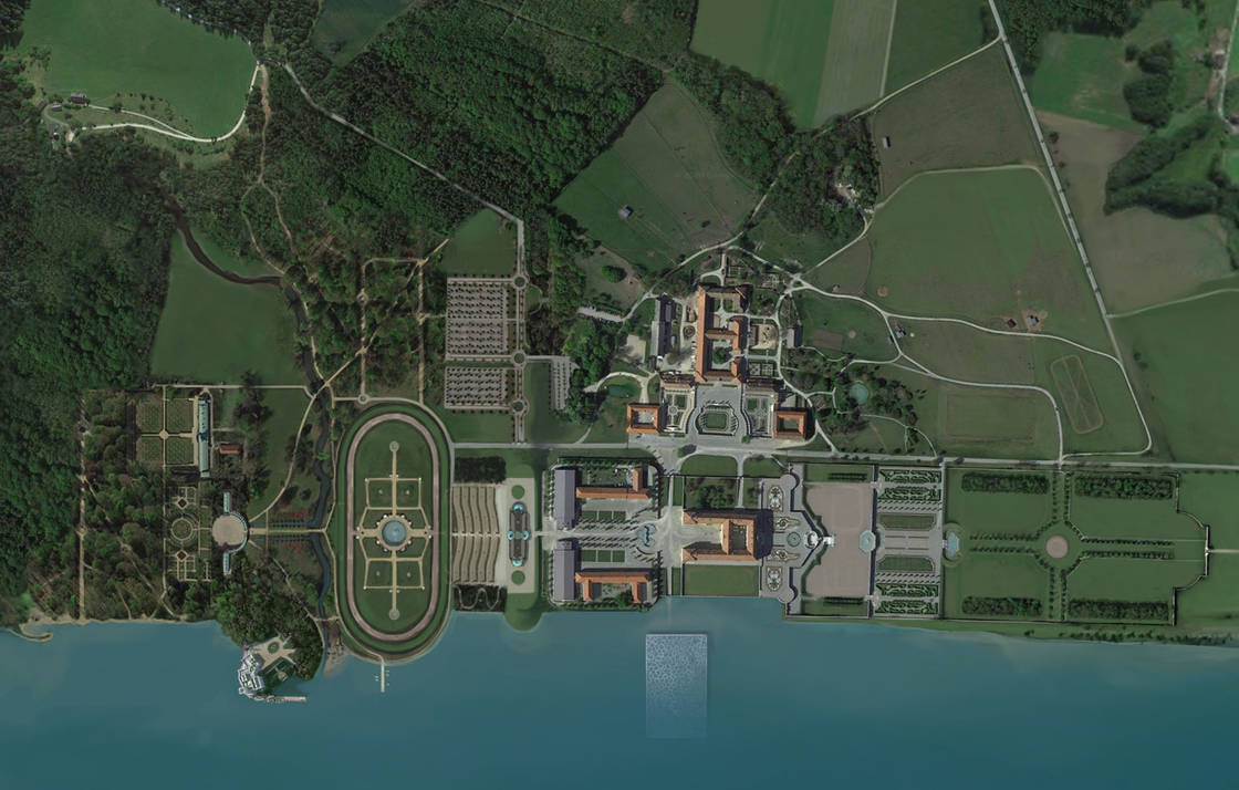
Picture manipulation by RPS Admin