
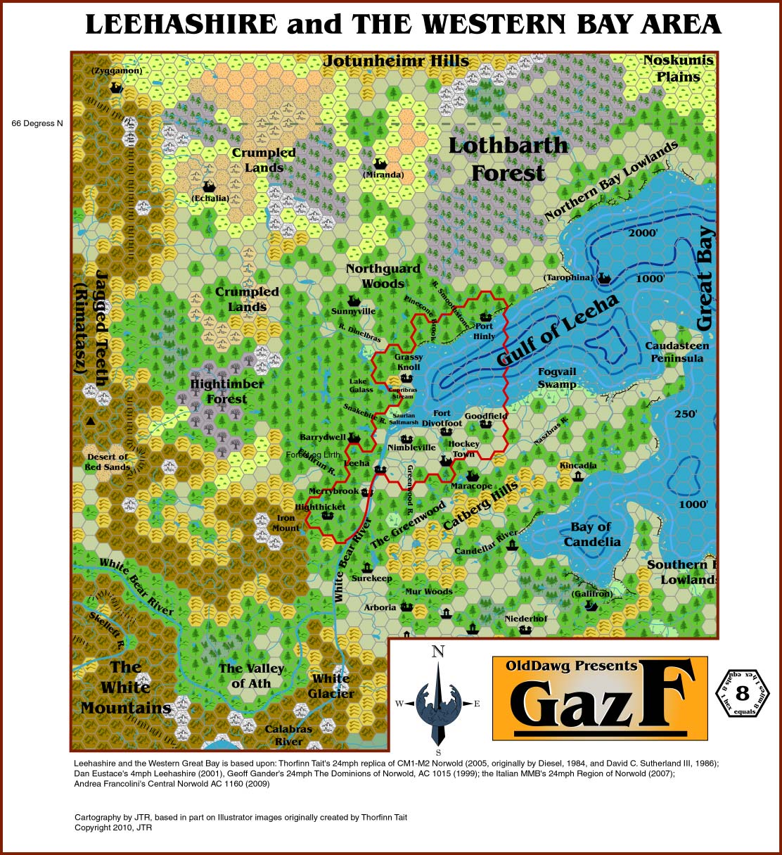
Land of Leeha
by JTR from Threshold Magazine issue 7by JTR
The Land
Leeha and its fellow halfling holdings are situated around the westernmost extent of the Great Bay of Norwold. It is a beautiful region of gently rolling hills, forested plains, and meadows populated by the shortfolk, sedentary and semi-nomadic humans, and scores or hundreds of humanoid and giant tribes.
Most of the area is part of the Great Bay’s Coastal Plain
Lowlands, which extend over 150 miles westward. The Lowlands normally
run from sea-level to 150 feet in elevation, but the western portions
reach 200-300 feet before yielding to the hills and mountains of the
Icereach. In addition, cliffs line several segments of the coast, and
local rises and depressions are common.
Map of Leehashire and the
Western Great Bay
http://pandius.com/leeha_gazf11.jpg
The southern and western Lowlands are moderately fertile. There is a
healthy glacial deposit layer on the surface, and the soil is capable
of sustained agriculture. The lowlands south of the Catbergs are
particularly rich, but the capabilities of the local humans are too
primitive to make much use of them. The northern Lowlands are much
less supportive and yield only a subsistence-level of productivity.
The most notable feature of the Lowlands is the narrow Caudasteen
Peninsula that curves out into the Bay. The halfings control the
region of the peninsula north of the Catberg Hills. The eastern tip
has a very sandy soil, and its coastline is steadily eroding without
adequate coverage by trees and grass. Near the middle of the
Caudasteen, fields, meadows, and short-cycle farmland replace the
cattails and scrublands. The farms along this fertile strip generate
sizeable crops, and the halflings tend to imported fruit trees that
are kept in special baffler orchards that partially deflect wind and
precipitation and trap heat.
Snow tulips are a flower unique
to Leehashire, blossoming in both summer and first spring (see
Climate and Environmental Notes). They appear in a variety of hues
that form intricate designs, with colors ranging from snow-white to
yellow, orange, pink, red, and deep blue.
Hills and Mountains
High elevation terrain brackets the Gulf region on all three sides.
The closest of these formations are the Catberg Hills along the
southern end of Leehashire. The Catbergs are a minor ridgeline on the
Caudasteen that makes a useful natural marker for the halflings’
borderland territory. The Hills are a conglomerate of sandstone and
shocked quartz whose formation is relatively recent – an
extrusion dating to the destruction of Alphia1.
Its elevation varies between 300 and 760 feet.
The Catbergs are infested with goblins and hill giants. Orcs are also present to a lesser extent, but that population is still recovering from its defeat at Lake Glasst. Furthermore, there are a number of wildcats, pumas, and ebon tigers in the Hills for which the region took its name.
According to the barbarian nomads, the northern Jotunheimr are an ancient haven of giant clans (hill and frost) and unallied humanoid tribes (mostly trolls, bugbears and orcs). Like the Catbergs, these hills are a mixture of sandstone and shocked quartz, but within its caverns are also deposits of lead, coal, and a strange powdery mineral which the locals know to give off a strange sickness. The elevation runs from 210 feet in the east to 1300 feet in the west.
The Icereach Range is a complex and daunting system of mountains to the west. It is often subdivided into several smaller systems, beginning on the Denagothian Plateau in the distant south and ending just short of the frigid waters along the continent’s northern coastline.
Those mountains north of the White Bear River are called the Rimatasz (literally, the Jagged Teeth). The major divides exceed 9,000 feet, but even the unstructured south tops 8,200 feet. The southern peaks block the strong and chilly northern winds, so the surrounding foothills and lowlands suffer less from the snow blizzards so common to the rest of the area; however, these areas are at risk for avalanches.
Platinum exists in the northern third of the Rimatasz, silver and electrum are plentiful in the middle, and gold lodes are common in the south. The extreme southern end of the Teeth is ruled by Kiriakiss, a huge female red dragon. She is served by hill giants, orcs and goblins.
South of the White Bear are the White Mountains, one of the largest sub-divisions of the Icereach. These mountains continue into the south and west for many leagues, and the local mountains surpass 16,000 feet. A few mountain giants live within the obscured highlands, but frost and fire giants are more common. The White Glacier is an ice covered valley that opens out to the northern face of the eastern mountains. These mountains are particularly rich in gold and precious stones, but the local dragons are extremely territorial. Humans and halflings alike have tales of parties that ventured too close to the peaks near the White Glacier and suffered a cruel demise at the claws of the beasts.
There are also dozens of migratory dragons in the White Mountains that fly down into the White Bear River Valley and the lowlands south of the Catbergs during late spring and summer, although those that stray into Kiriakiss’s domain are typically slain by the large female.
Finally, the Crumpled Lands are fractured terrain between the Jotunheimr Hills and the Rimatasz that were produced during the destruction of Alphia. The southern portions of this feature have been slowly eroded down to undulating hills over the centuries, but the north still bears its jagged scars. Both rock and sand deserts fill much of the span between the Crumpled Lands and the hill country, but some grassland and woodlands have taken root. This region also contains lowland glaciers whose migration speeds decelerated over the past millennium. Today their edges are shrinking annually.
Forests
A thin woodland system covers the Lowlands well into the mountain foothills. The densest area is directly west of the halfling settlements. The trees are broken frequently by small meadows, glens or herbaceous fields. In addition, thousands of small lakes are scattered about, testifying to the historic presence of glaciers.
The Greenwood consists of the forest tract north of the Catberg Hills. Currently the only concern for travelers is the abundant wildlife, but in times past, the Greenwood has been the site of many battles with the Catberg orcs and their allies. The Greenwood is considered the halflings’ borderland territory.
The woods of the White Bear River Valley (Ath) can be particularly thick, with a multitude of young trees crowding the river shore. There are areas of older and larger trees further upriver and in the highlands of the Rimatasz.
The woodlands due west of the Gulf are traditionally thought of as two or three distinct forests. The Hightimber is the forest between the Rivers Dinelbras and White Bear. Its oldest section is directly north of Leeha, and little underbrush save moss and a carpet of needles can be found between the tall evergreens. The remainder of the southern forest is thick with smaller trees and ground cover comprised of thickets, brambles and ferns. The Hightimber continues up into the Jagged Teeth, but a recent forest fire left millions of acres of land burnt. It is doubtful that this section will recover, and hardy grasses have already colonized some of the exposed areas.
The Hightimber continues above the River Dinelbras under the name of
the Northguard Woods. This is a young stretch of woodland, and the
small trees are densely packed as they compete to establish
themselves. Travel is very difficult through the tangle, but the
trees form an important protective barrier. These woods and the lands
beyond are mostly unexplored wilderness
Near the source waters
of the River Smoothstone, the forest undergoes a significant
transition to a sub-arctic taiga. To the halflings this is still a
continuation of their Northguard Woods, but to the barbarians and
elves it is the Lothbarth Forest. Wildlife is uncommon in this area,
giving the Lothbarth an eerie, empty feeling.
Surprisingly, there are hardwoods west of the Lothbarth. These areas experience an unusual warming air mass originating from Kaarjala, a land well north of the Great Bay. Barbarians commonly encamp here during the summer months.
Waterways
The Great Bay of Norwold dominates this region of the continent. Before the the Great Rain of Fire, the Bay was comprised of several different large inland lakes. Its current appearance is a product of rising global sea-levels and the earth-shattering magic of Alinor. Harbor seals, belugas, and even the rare wayward sperm whale have been spotted in the Bay’s open waters. The waters are rich with sardines, squid and other life.
The western extreme of the Bay is the Gulf of Leeha, which the halflings refer to as the Abbatarth Sound. Most of the Gulf was once above sea-level, but the destruction of Alphia collapsed the plain and tore open a deep chasm into which the sea poured. The Great Bay’s deepest point (2,674 feet) exists in the Gulf midway between Port Hinly and Goodfield.
“Abbie” and “Bailey” are the Great Bay Monsters, legendary creatures of the Gulf waters around Port Hinly. The local Harborhin treat the monsters as either a joke or with the utmost seriousness. Ships that fail to return to port are blamed on “Bailey,” while those that safely came back to port were under the protection of “Abbie.”
On the opposite side of the Caudasteen Peninsula is the Bay of Candelia. Prior to Alphia’s fall, this was a large freshwater lake. The regional destruction opened the lake to the Bay’s salt water, which killed the local fauna. Many of the migratory dragons that venture out of the White Mountains lek here. Aerial tumbles are a common sight as each breed in turn enters its mating cycle. In most years, one or two white dragons will attempt to establish a permanent dominion around Candelia during the winter when the rest of the flock returns to the mountains; however, it has been over a century since a given dragon held the Bay for more than a decade.
Today, the Gulf and Candelia both have ample fisheries and lobster beds. Ice can form over the surface during winter time. The northern Gulf coast is guaranteed some coverage, but the warning sign for the great freezes comes when an ice bridge connects the northern coast to the tip of the Caudasteen.
Ice bridges also isolate the Bay of Candelia around the same time, but the middle of the Bay remains ice free for all but the harshest winters. Many beluga pods take sanctuary here at that time, but the natives – and some wildlife predators – have learned how to use the ice openings as a means of surface whaling.
The White Bear River is a major waterway that leads high up into the western mountains. The river continues for over 400 miles further west into strange barbarian lands. It is navigable for most of the year. The cold river is deep and slow moving as it passes through the shire. In some places, the river can be over a mile wide, depending on the season. The banks tend to be fairly steep as the river winds through the upper valley, but it is not so in all places.
The Skelleft and Calabras Rivers are large tributaries of the White
Bear that drain the great glacial lakes further south. Their routes
are more difficult to traverse, with numerous rapids and stone or ice
bridges reducing clearance. Of the two, the route of the Calabras is
the more dangerous.
After the White Bear clears the mountains
it is joined by the Highthicket and Fishrun. Some stretches of these
rivers also contain significant rapids, so exploration of their upper
limits must be done with canoes and rowboats that can be carried
along the shore.
The Greenwood River originates deep in the Catbergs and flows through the forest and across farmland before joining the White Bear just north of Leeha. At the other end of the Hills, the Naszbras River travels through the fields just south of the shire. It terminates at the desolate Fogvail Swamp on the Gulf coast.
On the Gulf’s western shores, the Snakebite River sports an assemblage of poisonous serpents unusual for this climate. The snakes hibernate most of the year, but starting in early summer, they rouse and disperse throughout the Hightimber, aggressively hunting small prey and each other. The Snakebite finishes its course in a marshland (the Saurian Saltmarsh). Hin rarely travel here, but they tell stories about the fierce Children of the Dragon (lizard men).
The River Dinelbras is an important navigational marker for overland travelers. In addition to dividing the Hightimber from the Northguard Woods, the Dinelbras has a number of tributaries that segment the northwestern forest.
The Cupribras Stream is a minor waterway connected to Lake Galass near Grassy Knoll. Many of the Snakebite’s dispersing serpents end up here. Additional minor rivers include Pinecone Brook and the River Smoothstone.
There are lakes, brooks, and rivers throughout the greater region, particularly in the area south of the Catbergs. Of these, the Candellar River is the most noteworthy. Its southern and northern banks are split between humans and humanoids, respectively and delineates the Caudasteen from the south.
Other Locations
Fogvail Swamp is a dark and murky place on the Gulf’s southern shoreline. It is often shrouded in mist, and few dare enter. Pits of quicksand are interleaved with peat bogs, and all manner of denizens lurk behind the swamp’s twisted and stunted trees. Nearer the coast, the swamp converts into a salt marsh with stagnant water infested with insects.
The Saurian Saltmarsh is a small marshland at the mouth of the Snakebite. It is the home of cold-adapted lizards that are generally active only from late spring to early autumn. They then go dormant in large colonies after the first frost and hibernate through winter.
The Kingdom of Alphia left ruins at several sites in the region, including Galifron, Echalia, and the now-submerged sea port of Tarophina. In addition to these sites, traces of Alphia can be found at other minor locations.
Likewise, Miranda and Zyggamon are remnants of Blackmoor culture. Human barbarians now use Miranda as their summer gathering point, ignorant of the locale’s ancient history.
Hockey Town, Barrydwell and Maracope were halfling communities destroyed by fellow hinucks, frost giants and Catberg orcs, respectively. Frost giants are also blamed for the destruction of Sunnyville, but elder halflings know that cannibalism was to blame. The hinucks avoid these sites.
Surrounding Lands
The Coastal Plain continues to the south and to the east unto the mountains of the Wyrmsteeth Range, forming Norwold’s Southern Bay Marches. The Alphan Peninsula is still further east. If one journeyed beside the peaks holding the White Glacier, he would eventually pass through a gap in the ranges and reach the edges of the Icereach Barbarians’ territory. From there, the Denagothian Plateau is accessible.
The Icereach Range grows ever more impressive as one travels west. One of the Range’s greatest features is the Arch of Fire – a great flow of elemental fire and lava tearing through the sky. The 300-foot wide tube of fire travels 75 miles between its anchoring volcanic gates, and it gains an additional 6 miles in height. The Arch can be seen up to 72 miles away at night, 48 miles in daylight. The lands between the volcanos are true wastelands criss-crossed by lava and with huge lakes of fire at their bases. There are many caverns in this area, and some lead into deep fissures. Bands of fire elementals are common here.
The nearby portion of the White Bear is surrounded by swamps, and there are barbarian lands further upstream. In the latter area is the Leehan Trail, an overland route around the mountains that leads to the remote Kingdom of Ghyr. All of these features are known to the more experienced Leehan explorers. Less well-known is the Desert of Red Sands tucked away alongside the Rimatasz. This desert is dangerous to all life as it is littered with a red ice-like substance that dehydrates whatever it comes into contact.
Northeast of the Lothbarth are arid grasslands of the Noskumis Plains, on which dwell nomadic barbarians and humanoids. This is part of a larger territory known as Viaskaland, and beyond that are the Autuasmaa Plain and the Kingdom of Kaarjala.
Finally, there is the large island of Nordenhafen in the Great Bay 70 miles due east of the Caudasteen. The island has little to show save scrub and grasses, yet a few dozen families eek out an existence by fishing the local waters.
Climate and Environmental Notes
The western Bay has unusual seasonal patterns with two springs and winters, and a summer whose temperature spikes to levels more appropriate to a tropical locale. These climatic oddities come courtesy of the Great Sampo, an artifact that keeps the Kingdom of Kaarjala from freezing over2.
First winter normally begins Tembiir3 15, with the temperature averaging 11° F (-12° C). Easterly winds pull moisture off of the Bay to generate 4.5 inches of mixed precipitation per month. The temperature declines 1 degree (F) every two days into the season until Dauntil 6, when a massive heat front moves out of the north and settles over the Gulf. Temperatures climb 5 degrees (F) per day for twelve days and then holds steady through the winter solstice (Dauntil 28, 4 hours of daylight). This run up is First Spring, and it is the best time to pick snow tulips.
At the start of the new year, temperatures plunge 7 degrees (F) a day as a regional Carnot Cycle is unleashed that draws all heat north to Kaarjala. Currently, the drop levels out at -21° F (-30° C), but that bottom lowers 1 degree every 15-20 years. Leeha is buffeted by chaotic winds from all directions. Rain and snowfall total 26.8 inches per month. In addition, late Nor’easters pick up floe ice in the Bay and scour the landscape.
Second Spring starts 70 days later on Odelin 15. The thaw starts three weeks prior, gaining 3 degrees a day until temperatures naturally vary between 30-45° F (-1 to 7° C). The rivers swell from the melting snow, and flash floods are common. This period lasts 10 weeks through the solstice (Mithintle 28).
Summer lasts 8 weeks (Goldaun 1 – Fyrtal 28). Temperatures rapidly reach 65-95° F (18-35° C). The temperature spike is a consequence of the Sampo’s venting. The period is muggy, with rain and hail common.
Autumn (Aumbyr 1 – Tembiir 14) has cool, refreshing winds from the north and east. Cloud cover is common, and the temperature hovers comfortably between 55-70° F (13-21° C).
1 The alphatian kingdom founded in Norwold by Alinor, as explained in “The History of Leeha” by JTR, page 25, in issue #6 of Threshold magazine and in “A Traveler’s guide to Norwold” by Simone Neri in this same issue.
2 See GazF10, The Kingdom of Kaarjala.
3 The Hin of Leeha use the same calendar as those of the Five Shire. See GAZ8, The Five Shires, Dungeon Master’s Booklet, page 15.