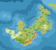
Ochalea, 8 miles per hex
by John CalvinMaps
Map of Ochalea, 8 miles per hex by John Calvin, August 2013 (Work In Progress)
Comments
This map of Ochalea is based off of maps created by Thibault Sarlat and Giampaolo Agosta (which in turn are based on a map by James Mishler).
Sources:
Outer World: Ochalea and the Pearl Islands, 24 miles per hex
Unofficial Maps:
Ochalea, 8mph by Thibault Sarlat, Ochalea Geographical by James Mishler, Ochalea Political by James Mishler
Notes on Ochalea
As of now, I can't find the original James Mishler Map - I'll keep looking, but if someone can throw up a link I'd appreciate it.- The text on some of the earlier maps is hard to read - right now I'm going through the Ochalean Gaz to try and fill in the blanks.
- The ocean contours are mostly my creation - I am currently working on the contours for the entire Sea of Dread in a separate project (yet to be released)
To Do List
- Add rivers.
- Continue to fill in labels pulled from other maps.
- Add in the cliffs on the northern tip of the island.
Add in roads.- Incorporate smaller island chains from the Mishler maps. May necessitate changing the ocean contours.
- Add sea trade routes.
- Add reefs.
References
- Ochalean Maps
- Ochalean Gaz by Giampaolo Agosta (pdf compiled by Alex Boucher) - the map in this pdf appears to be scaled at 12 mph even though it is listed at 24 mph
Thanks to: Thorfinn Tait, for providing some wonderful graphics to use in all of our mapping projects, and James Mishler, Giampaolo Agosta, and Thibault Sarlat for their work on previous maps.


