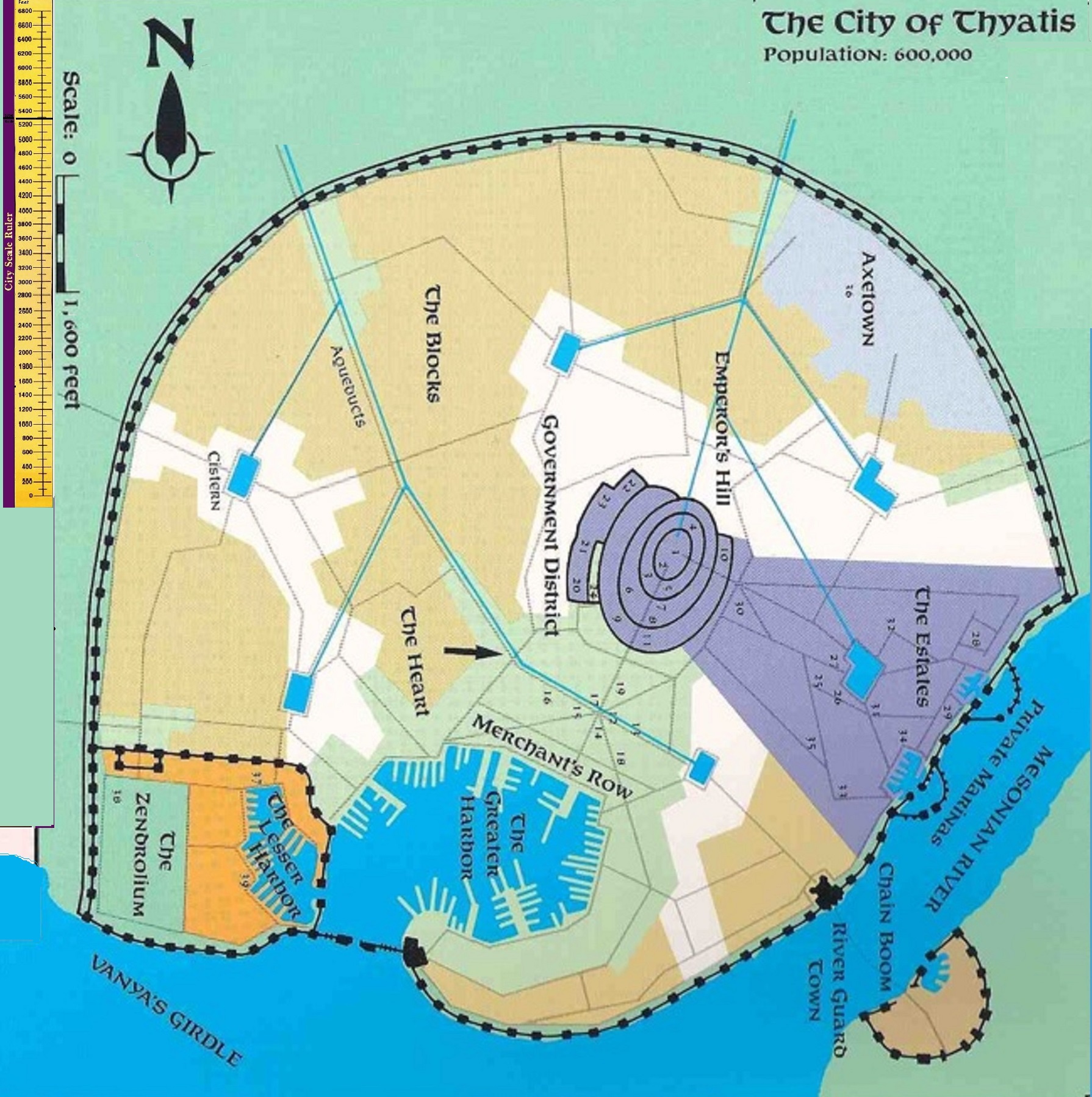
Thyatis City map
by RobinAs to this canon Thyatis City map
First problem; Logic and gravity dictates for Aquaducts to function a water source must exist higher up. The only higher regions of Thyatis are North, while Thyatis City lies at the mouth of the Mesonian River in the South.
To the southwest as the canon map dictates is an aquaduct coming, and another one to the Northwest. As a stand alone map based on Roman architecture Ok , yet Thyatis City is a part of a functional world, where magic does exist, yet not all is magic, and most is similar to Real World Earth, as such the same laws of Physics do apply.
As such there is NO Southwest source of way nor altitude (and as such no logic) to these Aquaducts.
Secondary problem is the scale of the map, (even if taking into account multi-tiered buildings are used) in reflection of the canon population of 600.000 (and later canon sources even much more), in an area of less than 2x2 miles.
Third problem with the Thyatis City and Thyatis country map is the coastline and River, which large contradict each other in the city location. The Thyatis country map also gives a road entering the city from the west after being merged together shortly before the city, one Northeast and another along the coast Southeast. None of these are possible when interacting with the canon Thyatis City map. Even if resolving the River width of the Country map, the roads and bridges cannot be resolved while staying in canon.
Fanon (Ramelin) added even a northern lesser road while staying further to canon, which is only logical as being the Capital
I checked and puzzled for a solution of this problem (made by two separate very good artists without awareness of the other's work in reflection to logic and physics and cooperabilities), without altering too much of the canon sources, and came up with the following solutions;
1 Turn the map Clockwise, so the the Canon West now becomes North. The Aquaducts originate now from the higer areas, as gravitationallt required. The Rotation also places the four Thyatis City Roads along the Thyatis canon roads, West, Northwest, North and East (which beyond the Mesonian River (using a rather massive bridge) can split going South east along the coast and East
2 Increase the scale to "1 inch = 1600 feet" instead 1000. This allows for even the higher numbers given to be a crowded (as per canon) city while still being functionally (as per canon). and the city becomes almost 3x3 miles.
3 The Mesonian River branches out, in several arms (as many rivers in Real Life also do) and a Rivermouth tidal swamp or mud area is created in between. The arm coming along Thyatis city is the one use for traffic as it is the widest and most table. The other waterways will then contribute to the canon country river mouth.
as such we will get the following revised map, which will much better fit to the Canon Thyatis country map (soon coming up in 1 mile hexes as well)
So Thyatis Central became another hex map on my list to finish
At least the City is now fit in correctly
Hope you like it thusfar
