
Ur-Carnifex Tribelands, 8 miles per hex
by John CalvinMaps
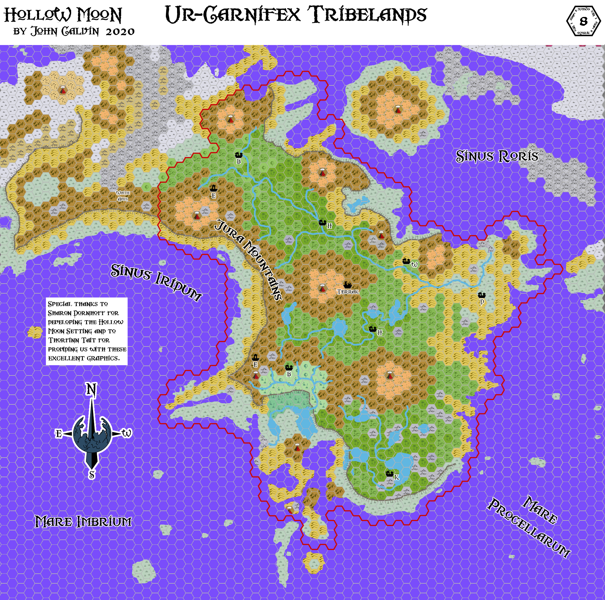
Map of the Hollow Moon, Ur-Carnifex Tribelands, 8 miles per hex by John Calvin, November 2020 (Work In Progress)


Comments
I've been wanting to work on this map for a very long time. There are probably extensive changes coming, but I need a starting point before delving into to many of the details.
Sources:
Inside Matera: The Hollow Moon by Sharon Dornhoff
Hollow Moon: Nearside, 40 miles per hex
References
Thanks to: Thorfinn Tait, for providing some wonderful graphics to use in all of our mapping projects, Sharon Dornhoff for developing the setting.
From Hollow Moon Cultures: Ur-Carnifex Tribelands
3) Vegetation on the plateau is a mixture of dense, shoulder-high bracken and cycads, and stands of slim tropical trees and palms; the latter tend to cluster along the banks of this sodden land's hundreds of creeks and rivers. The central portion of the Ur-tribelands is sunken several yards below the plateau's rim, forming a shallow series of long, narrow lakes that teem with fish and crocodilians.
4) Bejmat - Terrain: Rivers, riverbanks and the surrounding forest-strips; live in palm-thatched wooden huts, mounted atop poles in the middle of the river for defence, and keep their manwuk-herds corralled on sandbars when they're not on hand to watch for rustlers.
5) Dubi - Terrain: Flat brushlands of sago palm, bracken and cycads; build lodges for males and for ceremonies on the ground, but live in defensible stilt-houses* of wood and thatch that rise dozens of yards into the air Numbers: 8000+
6) Ebelamga - Terrain: Cliffs and jagged foothills of the Juras, where they abut on the plateau, and other free-standing rock ridges; Ebelamgas have no permanent residences, but camp out on ledges or mountain meadows for a few nights, then move on
7) Hsthkek - Terrain: Deepest patches of tangled, impenetrable forest, usually along streamsides too narrow or fast-flowing for the Bejmats; villages are mere camps, with only fire pits, crude manwuk-corrals, and a single "male's lodge" erected from palm fronds, but shamans reside in elaborate thatched huts in which shrines for idols are adorned with tribe-members' shed skin-scraps and past sacrifices' split-open bones
8) Kasepauk - Terrain: Central freshwater lakes of the plateau, usually only 4-6' deep, plus the surrounding lakeshores; Kasepauk villages lie inside crude palisades of palm-trunks, and consist of one communal lodge for each male-kin coalition, plus a larger "males' lodge" and individual huts for Big Leaders (if any) and one aged female soothsayer/seer
9) Waknavesu - Terrain: Hills and other dry elevations with loose, arable soil (rocky hills are Ebelamga territory), much of it divided into regular plots and seeded with sago or tuber-plants; enclosed in stockades with real gates, and sturdily constructed using wooden pegs, Waknavesu villages consist of slat-board huts and lean-tos for families, corrals and pens of A-frame fencing for livestock, and immense split-board lodges for unwed males, all built of bare, unadorned wood and devoid of carvings or any other trace of personal expression
2) Situated along the northern flank of the inhospitable Jura Mountains -- a jagged, impenetrable maze of sheer, razor-slim rock ridges, dotted with steaming volcanic vents -- the brushlands and palm-forests of Matera's Ur-tribelands shouldn't exist at all, outside the subtropical Midlands ... let alone, 800' above the iced-over surface of arctic Sinus Roris! But between the elevation of the Ur-Carnifex's last worldly refuge (altitude, in the Hollow Moon, keeps regions AWAY from the crystalbarrens' chill), and the continual warm mists and intermittent rainfall which those numberless steam-vents spill down from the mountainsides, this verdant plateau is an island of wet, temperate springtime in a sea of dry, sub-zero desolation. Enclosed on its long southern face by the Juras, and ending in treacherous cliffs which overlook Sinus Roris to the north, the Ur-Carnifex homeland is virtually inaccessible from the world outside; only the rocky, crumbling cliff-face at the westernmost end of the plateau, or the Qaurikka-held glaciers of the frigid eastern slopes offer possible routes of entry ... or of escape, from the tribelands' carnivorous inhabitants.