
Locations on or close to Mount Dread
by RobinOk analyzing First Quest to determine all locations on/close to Mount Dread.
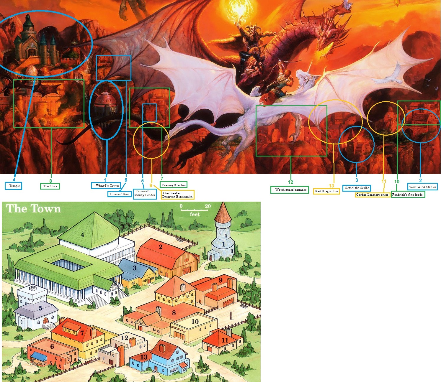
1 Wizard’s Tower, 2 West Wind Stables, 3 Sethel the Scribe, 4 Temple, 5 Foxworth Money Lender, 6 Thieves’ Den, 7 Evening Star Inn, 8 The Store, 9 Ore Breaker.Dwarven Blacksmith, 10 Fendrick’s fine foods, 11 Cordac Leatherworker, 12 Watch guard barracks, 13 Red Dragon Inn
The Town analysis; At first It is not a town nor a City, even though both these terms are used in FQ…it is a village, as determined by the estimated population and the number of buildings.
The Temple was probably the first building here, maybe at he same time as the Wizard’s tower, then a store and other structures followed. As there are no typical residential buildings it can be assumed all the people live in the assigned buildings with their family members, all working on the same. As it was originally most logical first a temple/cloister the amount of cleric, monks and nuns should be high. As the population was added to sustain these monks the military importance of the location became evident and a barrack/simple fort was added to the community. All in all estimated there are three general groups; The clergy, the military, and the population. Each of these groups are roughly 50 people up to a maximum of about 80, making the total population between 150 with an average maximum of 240, making an average total of 200 logical.
The in FQ supplied map of “The Town” is displayed as if on flatlands, while the text suggest it is on hills, or even mountains close to Mount Dread. The old Castle of Demara is several miles away yet can be reached by walking in a day (FQ page 10), which would be about 12 miles from the town in hilly area and about 8 miles in mountainous area. As the castle of Demara being within a day’s walking distance, and the last adventure is placed ON Mount Dread which is a large area, it thus actually places (due the walking distance) “The Town” in either a valley (mostly hills), or on this mountain.
As the second adventure the manor on the hill is "far outside of town", and on a hill, the foothills of the mountains seem to be best fitting.
The 3rd adventure is actually in “The Town” as the large hammership lands in town. This can be a real landing, yet also a embanking, while still remaining afloat, enabling the needed repairs done with ease. If really landing (ie on its bottom) a wharf deck would be needed, to repair sections on the bottom, as such is not available in this settlement, an embanking would seem more logical. Especially in the light that “The Town” is most probably in a valley or on a mountain(side), making floating embankments possible. As being lawful spelljammer captain, an embankment would also not damage farmlands close to the town, especially if needing the supply/tools/manpower to help...all reasons to embank rather than land.
This all in all makes the given map of "The Town" feeling flawed. Yet there is no real problem as the FQ also gives the illustration of Jeff Easley; Siege of Lord Eyrie's Crag, as if befitting here. it in fact gives actually a more functional and reasonable picture of “The Town”. Here the designated areas as given in the FQ box yet now on the art itself.
The depicted battle could easily be from the evil humanoids within Mount Dread. I have read a fanon suggestion that the evil mages is a Lich, which sounds reasonable given the background. And the suggested extra lower levels give enough space to have evil dragon minions for the humanoids (under control, trained or subdued by the humanoids an/or the leader which might be the mentioned lich).
When adding all this information, together with the X1 map, and the given location of Mount Dread as per canon,
Mount Dread is located on the border of Darokin and Karameikos about 16 miles west of Mount Pavel in the Black Peak Mountains
As Mount Pavel is on the northwest of the Foamfire Valley and south of the Lost Valley, we then can assume Mount Dread is west, on the eastern side of the valley through which the Achelos River comes out of the Mountain. (which can just be seen in the maps here left high of each map.
This does seem a logical location, and the valley can even be attached to a pass to Darokin, giving a logical/political/military reason for the canon description of the Ruler of Karameikos (be it King or Duke depending on the year) to raise Military in this region, beyond keeping the humanoids down.
Though seeming more logical to use the suggestion based on all the hints in FQ, any DM may still prefer to use the canon map, which with some serious map tweeking is also possible on the very location.
Any suggestions to this research is welcome.