
Mystara on the map of Flanaess
by RipvanwormerI had the idea of mapping the Known World nations on to the map of the Flanaess from the Greyhawk setting to make more room.
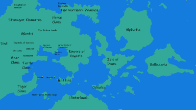
Wendar: Corresponds to Blackmoor
Ethengar Khanates: Corresponds to the Tiger and Wolf Nomads
Horse Clans: Correspond to the Rovers of the Barrens
Broken Lands: Correspond to the Bandit Kingdoms/Horned Society/Iuz
Glantri: Corresponds to Perrenland/Highfolk
Republic of Darokin: Corresponds to Bissel/Gran March/Veluna/Furyondy/Dyvers/Ket
Sind: Corresponds to the Plains of the Paynims/Dry Steppes
Elk Clans: Corresponds to northern Keoland
Bear Clans: Corresponds to the Yeomanry/Geoff/Sterich
Turtle Clans: Corresponds to southern Keoland and the Hold of the Sea Princes
Tiger Clans: Corresponds to the Amedio Jungle
Alfheim: Corresponds to Celene
Rockhome: Corresponds to the Lortmils/Principality of Ulek
Ylaruam: Corresponds to the Bright Desert
Thyatis: Corresponds to the Great Kingdom
Hattias: Corresponds to the Scarlet Brotherhood
Karameikos: Corresponds to southern Nyrond
Five Shires: Southern Nyrond, just west of Karameikos
The Northern Reaches: Corresponds to the Thillonrian Peninsula
Heldann Freeholds: Corresponds to Stonefist
Then I just added Alphatia, Ochalea,the Isle of Dawn and so on to the east.