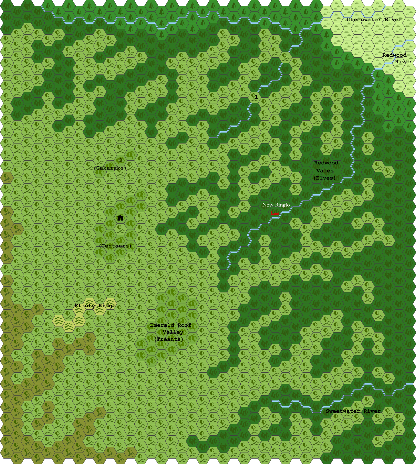
Map
by WingofCoot3rd version of the map
Changes -
Labels:
"Redwood" instead of "Westryn"
Moved the "Gakaraks" label
Features:
Added Sweetwater River (name taken from DA4 map) - also some changes to the shape of the two southernmost valleys
Trimmer back the mountains a bit, and changed them to "Forested mountain" hexes
Reshaped the Flinty Ridge, and changed it to "grassy hills" hexes so it doesn't look so barren
Added "camp" icon to the Centaur valley
--
Elevation notes
Highest peaks of Flinty Ridge 2500'
Higher peaks outside Flinty Ridge 2200'-2300'
Main level of uplands 1900'-2000'
Edge of uplands 1800'
Elven Vales ridge tops 1600'-2000'
Emerald Roof Valley floor 1600'-1800'
Centaur Valley floor 1500'-1600'
Evershadow Forest valley floor 1400'
New Ringlo 1000'
Redwood River valley mouth 800'
The mountain hexes to the southwest rise up toward the central mountain spine of Jomphur. These are not considered part of the Sylvan Highlands. The truly high mountains of the central spine are far off this map.
--
Flinty Ridge: This area includes the highest elevations of the Sylvan Highlands proper, up to 2500', and these hills are more rocky and steep with sheer cliff faces, an abundance of large boulders, etc. There are limited places for trees to take root. Even in the flatter areas, there is a surprising lack of trees - the area is predominantly grass and shrubs, even though it is far below treeline. It is similar to the southern Appalachian balds.
These hills have a number of caves, which serve as lairs for saber-toothed cats, cave bears, and rock baboons.
First draft map of the area - still working on names for all the features. This is just the terrain so far, at 3 miles per hex.
The mountains in the southwest and the grasslands in the northeast are not part of the Sylvan Highlands proper.
The Sylvan Highlands covers about 110 miles north to south and about 80 miles east to west, slightly less than 9,000 square miles (About the size of Wales or New Hampshire). The Redwood elves inhabit less than half of this total area.
The western/southwestern half of the Sylvan Highlands plateau is mostly uplands with isolated higher elevation valleys containing predominantly oak or oak-hickory forest. This area is primarily home to those sylvan creatures which wish to distance themselves from the primary elven population centers, such as blink dogs and actaeons, and those which would be highly dangerous to the elves, such as gakaraks.
The eastern/northeastern half of the plateau is deeply dissected, being composed mostly of elongated, steep-sided valleys at a lower elevation (containing pine forest) separated by relatively narrow ridges (covered with oak-hickory-pine forest). This area also includes hills which are separated "islands" of the plateau, often arc- or horseshoe-shaped when viewed from above.

