
It Started with a Single Hex-Map
by Geoff Gander from Threshold Magazine issue 5It Started with a Single Hex-Map…
by Geoff Gander
Fall 1996:
I was starting my final year of undergrad and had been a member of the Mystara Mailing List (MML) for a number of months. I had made a few posts, such as the original timeline of Varellya (my first contribution to the Vaults of Pandius), and was following most of the active threads, even though my campaign at the time did not end up using most of what I was reading. It was a heady time—the Internet was still a new thing for me and the Mystaran community was still in its infancy. It was a free-for-all of ideas because all we had at that time was the “canon” rule set; everything beyond the Known World and Alphatia was pretty much a blank slate. Good quality scans of maps simply did not exist, mapping software like Hexmapper had not been invented yet, and Thorf’s great mapping project1 was beyond even our wildest dreams. We were still discussing whether we could convince TSR to bring back Mystara.
Then, as now, much of the discussion on the MML focused on the Known World. This was, of course, sensible because that region was detailed in published materials and it was the one thing that united us as fans. But every so often I looked at the world map in the Hollow World boxed set, and the map of the Sea of Dread that came with the 1011 AC edition of the Poor Wizard’s Almanac (which detailed the northern coast of Davania), and I began to wonder. Wouldn’t it be great if we could someday map out Davania to the same level of detail as TSR had done with the Known World? I thought of the interesting land forms that could be created… the opportunities to create new cultures… and I grew excited at the prospect of stepping over the metaphorical border and exploring. And so I decided to do it myself.
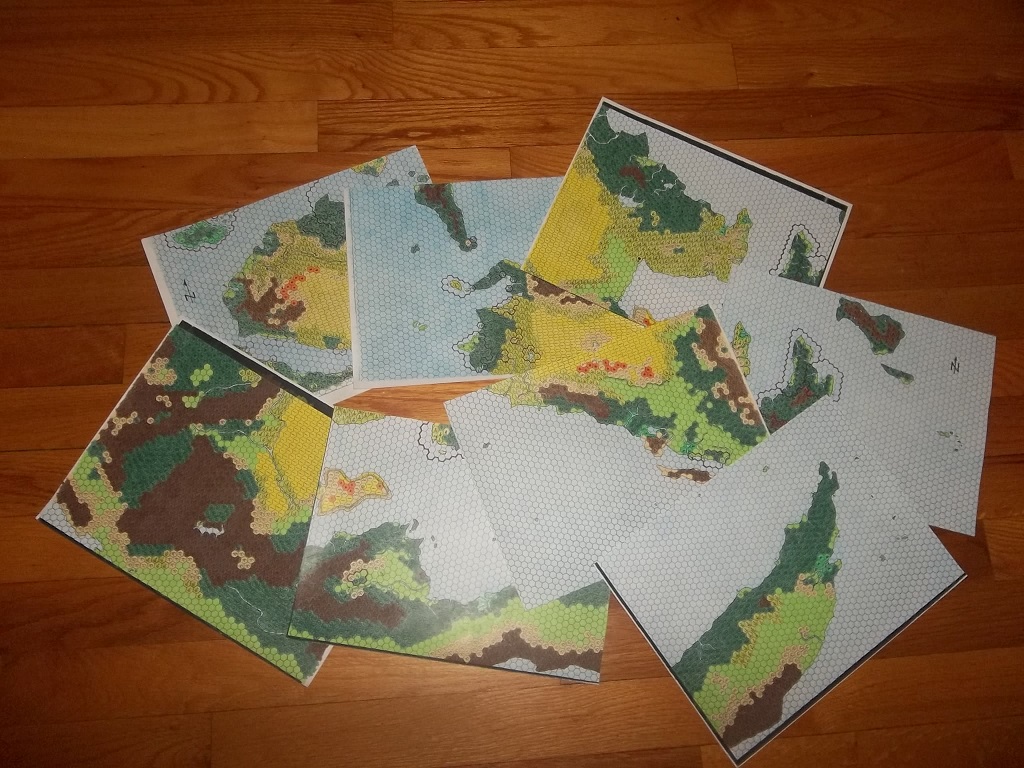
The first map was of the Adakkian Sound region. It was the hardest one to do because I knew all the other maps would be based off of it, and any error would only be magnified over time (I had already decided to map out the entire continent), but I saved myself a lot of pain by setting the scale at 72 miles per hex and basing it off of the map from the Poor Wizard’s Almanac. But what would I do once I ventured off the official maps? The only thing I had to guide me was the Hollow World map, and I developed a formula to convert the distances between the two maps. The rest of it was eyeballing to make sure the contours, major rivers, and vegetation zones of the hex map matched those of the Hollow World map. Amazingly, I managed to recreate the coastlines in larger form with only a moderate amount of cursing. I then headed west to map the southern shores of the Izondian Deep, and then eastwards to the Isle of Cestia. At the same time, I put down numbered markers for interesting places I had planned to develop later. Some of them, like the major settlements of the Adakkian Sound and Cestia, were fleshed out to at least a basic level of detail. Others, such as those of Izonda and the places in the far south, were developed by others.
The process of mapping was painstaking. In addition to drawing coastlines and rivers I drew each of the hex icons with a pencil—every tree, every reedy swamp, every mountain and hill on all of those maps. And then once I was finished I inked them all. Each map took a couple of hours to do in this way, and I hadn’t even started colouring! Ah, colouring… that was both fun and frustrating. Once I had gone through my pencil crayons to determine which shades I was going to use (making sure to buy spares in case a particular shade went out of stock) I set to work. Each hex coloured took me one step closer to bringing Davania to life, but it was a delicate affair because I had to make sure I used the same amount of pressure when I was colouring - I wanted the hexes to match as perfectly as possible.
I was mapping Davania, on and off, from 1996 until 1998. Each time I completed a map I scanned and emailed it to Shawn Stanley for inclusion in the Vaults of Pandius. I remember following the MML (and TSR’s Mystara Message Board) threads closely to see what people thought about this project of mine. While I don’t remember too many people chomping at the bit to run campaigns there, there was a fair amount of appreciation and interest in the work. But ultimately the work was done, and aside from mapping Denagoth and Heldann my hand-drawn mapping days had come to an end. But my Davania maps were not about to be forgotten.
Not long afterwards I ended up getting involved in the Mystaran Almanac during an expansion period. The editors wanted to cover more territory—including Davania—so I was offered the chance to manage it. I started up a project team, portioned out regions covering thousands of square kilometres each to eager fans, and let them go wild. I have to admit, I felt powerful. Here I was, overseeing the development of the largest continent on the planet, free to craft master storylines as I saw fit, and no one else seemed to mind because what my team got up to usually had little or no impact on the rest of the world. We pretty much did what we wanted, within reason, and I think that open atmosphere that we all agreed to foster is part of what helped create the rich mixture of cultures our community’s version of Davania exemplifies today. Naturally, we used the maps as our guide, and someone people really got inspired.
Davania Maps
“I’ve got an idea for crab-men,” Francesco Defferrari told me once, and he dumped a mini-gazetteer for Tlik’kkil, the Haven of the Crab-Men in my inbox.
“Sounds cool, go ahead!” I replied. Who was I to stand in the way of creativity? Besides, it was thinking outside the box and that’s what I decided Davania should be about. Francesco delivered, and so did Alex Benson (the Divergans), Jeff Daly (the Kwythellar Elves), and Ethan Denault (Thimhallan and technomancy). I did my share as well—mainly in detailing Kastelios and the other Milenian city-states, and of course crafting the Mystaran Almanac storyline concerning the Heldannic campaign in northern Davania, which did result in some major changes to how the Order was structured and how it operated. And as we continued our work for the Mystaran Almanac a wonderful thing happened: People in the broader community began to think about Davania. It had finally moved beyond the terra incognita at the bottom of a campaign map; it was becoming a place to visit, or even to stage campaigns. People also began creating their own maps, using mine as a base. The maps had truly acquired a life of their own, which is what I wanted in the first place. Looking back at what has been produced by the community over the past 18 (!) years, it truly has been an incredible journey—and to think it may have all started with a single hex map.