
Map of Threshold, research and compilation
by RobinOk the research on Zadreth triggered another research on the conflicts of the canon maps of Threshold from the B10- adventure and the Bluebox map (on which all later maps were based), as well as the ommitance of canon locations of one map/source on the other maps.
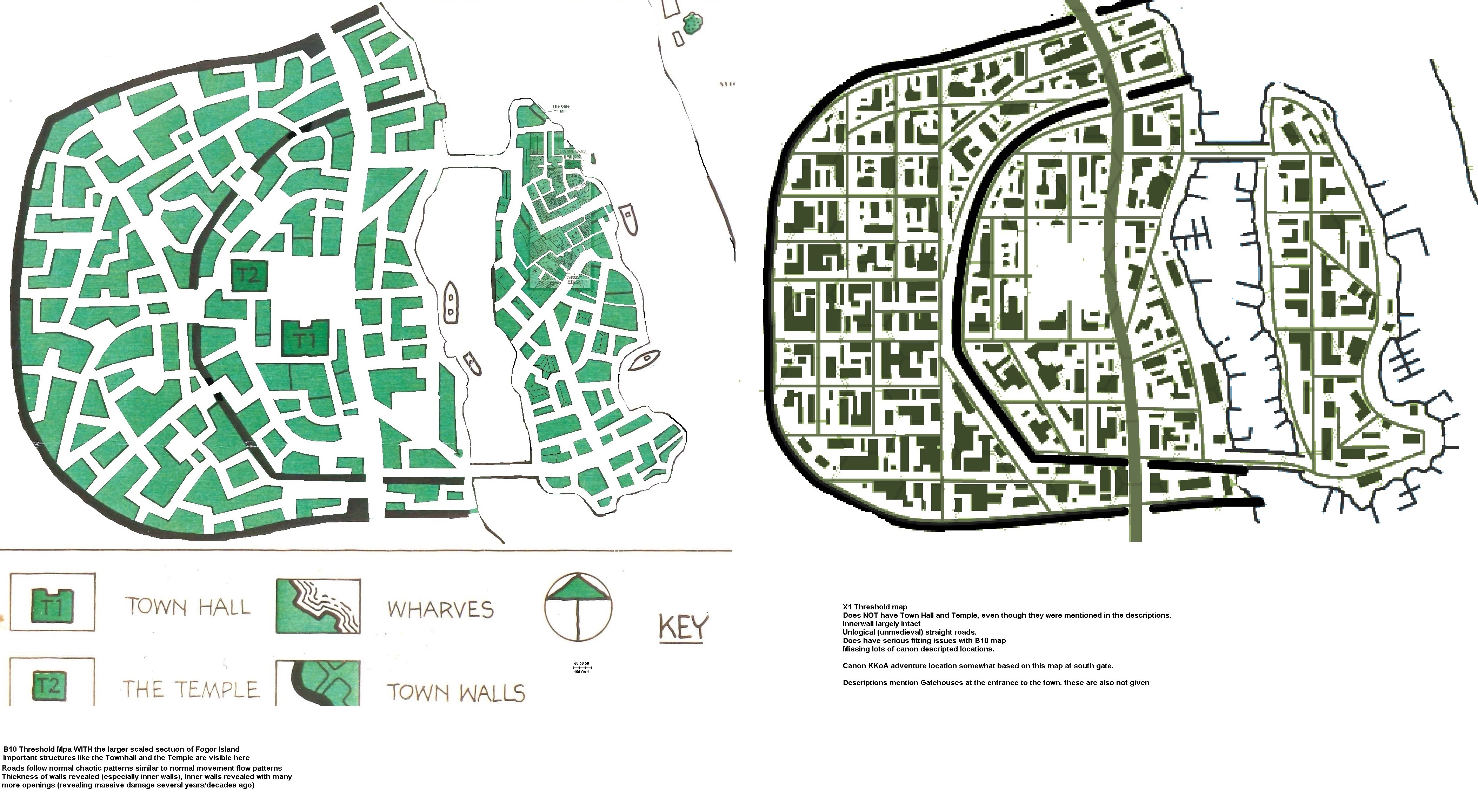
B10 vs Blue Box differences
I had to clean up the streets of B10, as these were also green. I also added the much larger scaled map of a section of Fogor Island as per same adventure.
This was somewhat tricky, as the streets did not really match. Using the rule that greater scale give more detail, I readjusted the roads were required using the small Fogor Island as a base,
Also The Fogor Island map has a clear detailed scale due the Crossed Swords Inn and Wererat Hideout maps of 10' scale rectangular grid.
B10 has much wider streets (this helps in the Law of Threshold not building within 50' of another building)
B10 Fogor Island is much more build against eachother (contradictionary to the law, which suggests these are much older.
B10 Fogor Island also clearly reveals several yards, which would help contributing to said law
B10 reveals ships between the bridges, revealing either these can be opened or can be crossed underneath.
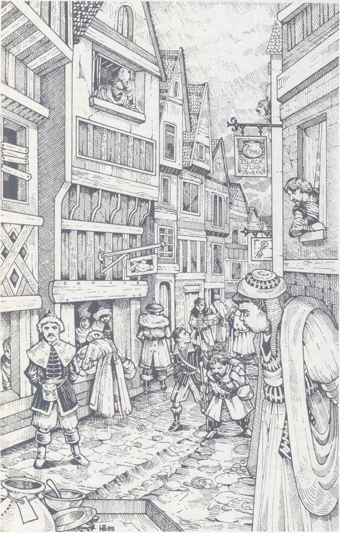
B10 clearly reveals the Town hall, which is also spoken of in Gaz1 and KKoA, and even revealed in illustration of KKoA see here; #1
The Townhall is clearly visible the highest building with a sort of tower on top.
That same illustration reveals at least the Northern Bridge is a solid stone bridge which can be crossed mast down or low vessels only and cannot be opened.
That same illustration reveals the old mill
That same illustration also reveals most buildings are half-timbered houses. the Text of B10 reveals most houses are made of wood, so that fits the profile of a crowded old settlement on Fogor Island
Visible on the B0 map are the inner and outer walls which are very wide, revealing these as a pallisade embattled earthen wall
B10 reveals the Temple as also a large structure. Both these are in the texts revealed as Stone structures suggesting a much older age.
The faith of Sherlane Halaran is defined as Church of Karameikos, suggesting the temple is reconverted, this is possible after desecration(war/fire). As the major populace is still adheringb to the Church of Traladara, several Shrines and hidden temples will exist in the city. Enforcing a faith would lower credibility to the Baron, so he accepts these grudgingly.(He most certainly will be aware of these existing, and might even know a few where.
There is some fanware, that the Temple will be returned to the Church of traladara after the Baron Halaran gets sick in 1008AC during the War /conflict with thyatis. This will certainly increase the followers of the Church of Traladara and lower those of the Church of Karameikos. This will be the first sign of a possible religious war coming up.
B10 reveals several walls on terrain patches, yet no structures.(beside those on Fogor Island and the two stone structures.
B10 reveals a great open place in the centre, a minor open place close to the southern inner walls, and another close to the river nearby. There is also a rectangular one North of the temple within the inner walls
B10 reveals in the outer city 7 open places; small rectangular south, somewhat north cupshaped, a small rectangular west, and one within the inner wall opening west, On the past NW from here is another somewhat rectangular open place. at the north is a very large open place, and against the northern wall a small rectangular one
B10 streets are a normal medival town chaotic in direction
In B10 the inner walls have 4 extra openings; SW medium widt, W very wide ..suggesting this may have been a gatehouse once), NW wide, and NW small. all these reveal this wall has lost its functionality, possibly in a war, where these parts of the wall were destroyed. Only the small opening in the NW may have been recently created as it is just a street width, and the walls is further intact there
There are at the outer wall two solid structures, and the Gaz1/X1/KKoA texts suggest these are gate houses, so the walls can be close if need be.
Blue box reveals roughly the same Shape
and it is clear Geoff Wingate made B10 based on this map (which is somewhat older)
Blue box shows thinner streets, more straight/rectangular. within these are several structures, some of a weird groundfloor shape, as well as several oddly small
The outer wall is a bit more straight in the west yet follows the same as B10 elsewhere, and holds openings at the gates and enter the river somewhat
the inner wall is much more different, as it has in B10 4 other openings which are not given here. There are no gatehousaes visible like as in B10
Blue box reveals several jettys along Fogor Island as wel as the river shore of the town proper.
B10/Blue box conflicts
B10 has Temple, Town Hall, natural streets, historic damages, most detail on a section of Fogor Island revealing history
Blue dbox has many structures, which were detailed by fans here;
Streets and Blue box structures do however conflict, and the overlap reveals many difficultis
Both the B10 and the Blue box map reveal conflicts with the 50 feet law, and so it can be assumed that structures being part of one larger structure still count as one.
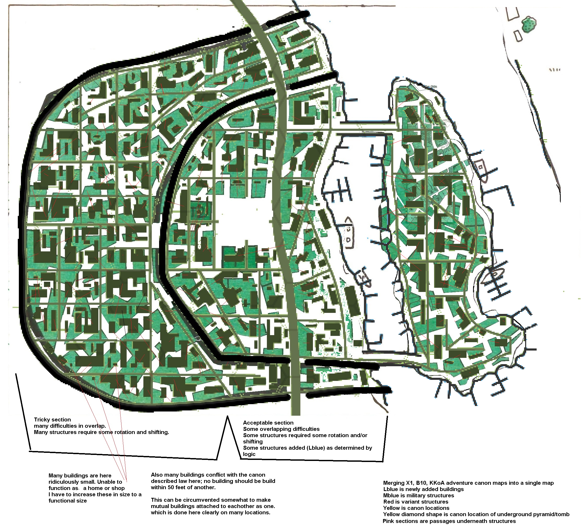
How to resolve.
As B10 has No structures it is best to try to impose Blue box structure upon that map. taking precedence to B10 given structures.
Many structures of Blue Box require some rotation and/or shifting (see thin red lines on the overlap map), especially in the outer Town. in the inner town most strcture do fit, however the missing town hall and temple decree some shifting. also several ridiculously too small structures(unable to function as a home/shop in any way) do not fit a bustling town and are thus subject of some minor resizing and/or reloocation
Introducing the map of the adventure in Threshold from Karameikos Kingdom of Adventure where the south part of the Town is detailed following the Blue box map as a base.
Folloowing all this canon material the threshold map B10, Blue Box does not fit the canon combined.
So both maps have to be merged complemening eachother where required
The Third map, is a merging of the two overlaid maps, with the additional information from KKoA illustration #1 and the KKoA adventure on the Key-Hamintep Tomb ended up as a total merging of all canon matter thus far. I also kept the textual information intact in the map, as well as faint historic references. This includes the local law of no building within 50; of another structyure, as well as the much more crowded Fogor Island according B10 picture (see below) and the text, which on Fogor Island at least, refrain mostly from the 50 feet rule.
I merged these maps together as one
Medium Blue are determined military structures
Yellow are specific canon locations and are labelled as such
Red are the structures from the redbox on the B10 map
the yellow diamond shape is the location of the underground pyramid of the KKoA adventure
The river sides to the town proper are using the redbox line, giving slightly more coast in the south
Fogor island's coast is using B10, yet with Blue box jettys.
As the Blue box uses way les structures as B10 on Fogor Island, the B10 map is used as a base and the Blue box structures are added were possible without conflicting. As several of these block streets, some redirecting and reorientation has been done.
Due to the shifting, turning and relocation within the map, some open spaces came to be where logically a structure should exist. these I have added (Light Blue)
Pink segments are structures where you can pass underneath
The sandy color are market places or larger open places.
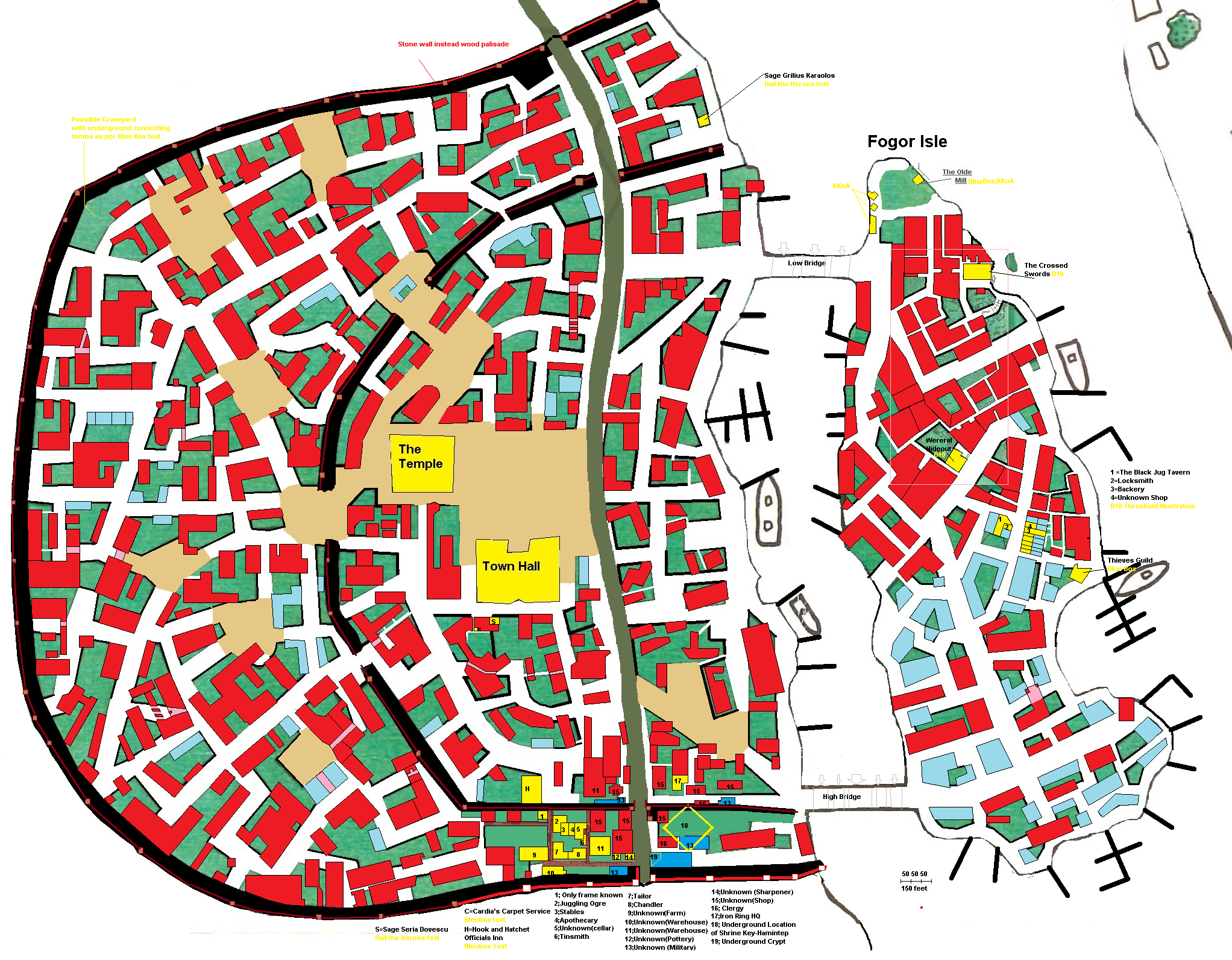
10-11-2021 Had to update the map to insert the information gained from the B10 Threshold Illustration on page 34
12-11-2021 Added several textual locations form the Red and Blue box. Added wall information and detailed wall and gates, added Hail the Heroes textual Locations
02-07-2024 After a remark the yellow text were illegible
I added background colors fo land and water
I also added the location for the Manor of Merrik Halaran (aka also the house of Alienne and Aleena Halaran) which is in Ochalean architecture.
Merging all this together, and with the Zadreth information compiled and created (including excell file) , and all other information fanon I came on this interesting set of Knowledge and history
Lugsid
-900AC Razed to the ground by Thyatians
Why did they do this over-destructive behavior?
This is beside Zadreth the only location where they did so.
Most possibly and logically Lugsid was under attack by the Thyatians.
A large group of its population resided on Fogor Island, where they could not really be attacked.
The remaining population (all of fighting capabilities remained in the small Town to defend.
The Town walls where Earthen pallisaded walls with on two or three locations openings closed by a gate.
The Bridges to Fogor Island were burned.
There was no weir, dam or other bridges over the river, and the river ran free and uncontroolled.
The large pier on Fogor Island suggest a ferry did exist to the other side of the river.
During the attack/siege (with no siege equipment) the town stood up against a Centurion (100 men)
Lugsid was described as having 500 population, 50% female(250 each), 25% too old or young(65 female, 60 male).
Estimating 10% of the able women(18) were willing to fight(half of which on Fogor Island), and 10% of the capable men(19) were stationed on Fogor island we have a total defensive force in the city of 171 men and 9 women for a total of 180 defenders of Lugsid.
And on Fogor Island there will be 232 women of all ages, and 60 too old or young men defended by 19 men and 9 women.
The better armoured and weaponized Thyatians with a Centurion (100 men and 1 Leader) would thus have to battle 180 defenders behind an elevated pallisade wall. That was most likely a long and arduous fight with lots of losses on both sides.
Eventually the vessel Proximus under the Hattian commander Dunkelwald, arrived upstream at Lugsid after a succesful attack on Halavos(today Kelvin) to aid the Thyatian attackers.
Unknown to anybody, they brought with them the Black Plague.
Momentarily disembarking south of Lugsid, they infected the Thyatians, and these infected the defenders of Lugsid in melee attacks. about a 40 defenders fled to Zadreth and Fogor Island, unknowingly spreading the Plague
The Proximus tried to attack Fogor island from the water, yet after several succesful sneak attacks, they were forced off the island and had to go further upstream to prevent a defeat and sinking of the vessel.Here they entered the Lake Windrush, discovered Zadreth, and attacked there instead. The plague already affecting both Lugsid's defenders as well as attackers the local commander decided to burn the village instead to prevent an overall disease running rampant. The order was also give to commander Dunkelwald, and both Lugsid and Zadrethwere destroyed in a few days. The defenders succeeded however to sink the Proximus, and when the few survivors of Zadreth later reached Fogor island, the Thyatians already had invaded lugsid. They killed all defenders, burned all buildings and tossed all infected ones (even those of their own) into the fire. They did not attack Fogor island as the river prevented access without bridges or the Proximus. Amongst the survivors on Fogor Island were clerics of Lugsid as well as Zadreth and these suceeded to quench the plague. The Thyatians all died. And when the survivors on Fogor Isle ventured amongst the burning buildings all they could do was to toss these bodies into the fires as well. The total body count in Lugsid was devastating however, and no more than about 100 men and women of all ages remained. These kept living on Fogor Island, while the razed town of Lugsid with only the Town hall and the temple remaining within the damaged town walls, was a stark reminder of the battle, until much later Sherlane Halaran came with a troop of soldiers. Unexpected and unable to resist, the inhabitants of Fogor Island accepted the new ruler, who besides strict and of another faith, was as benificial as possible.
Amongst the burned town remains new buildings were created. And later even outside the remaining walls of Lugsid, and he named it Threshold...for the town had been on the Threshold of Death. To keep infection chances as low as possible he ordered no buildings to be build within 50 feet from another, as well as flushing the sewer using a few water elementals. The plague did not return.
Today the town is rebuild, 5000 people currently live and work here, most Traladaran offspring of the Fogor survivors, as well as about 25% Traladaran-Thyatian Mixed, 5% demihuman, and 10% Thyatian. The Church of Karameikos is ordained by Sharlane Halaran, now Baron of Threshold, in the old temple repaired and altered to the new faith.
Threshold today
Clearly visible are the old town walls of Lugsid with several openings as being the inner walls of Threshold. The stone build Townhall and Temple still stand, with several repairs done. On Fogor island most of the original Lugsid buildings still stand. And while Threshold is more open, Fogor isle is more crowded and close together with only a few wider streets and more smaller streets.
Threshold build new houses around the old Town and erected a new earthen Pallisade wall as defence needed to repel humanoid attacks. Several farmers, loggers and fishermen live outside the town yet in case of an attack are welcomed within the town walls. On a few places the pallisade wall is already replaced with stone walls on the outside of the earthen wall, making a more steep and resistent defense. The Northgate is of stone in 1000AC, and the southgate in 1009AC. The Stone walls will be finished totally in 1014AC. (such structures take a lot of time and materials to build, are expensive, and income generated in Threshold is only a low amount above whats needed to sustain the population)
Ok, I hope you enjoy this research and compilation. As you see I tried to use anything canon and some fanon as one.
Of all the buildings from the Blue boxed set, non is removed in the proces, many are relocated nearby, and turned in some angle to fit the streets. at best and still following mostly the 50' rule
I Share this today after a frustrating week (working on these maps to calm down)as my BFF still makes no contact due her personal issues, and I am afraid due my depression to make contact. However, even if the answer is a dead end, we must talk...else I will lose myself completely due lack of resolving one way or another...so that's my goal in the upcoming time, to enable that to happoen. Cross y'r fingers for us please.
I have updated the final map, using the canon descriptions and fanon chosen destinations(as canon did not hold any better description on these) and Placed Cardia's Carpet Sercvice, The Hook & Hatchet Inn, placed gates as tex desribed and made the townwalls pure black. Where the Palisade wall is replaced with stone wall on the elevation, these are a red lines and red/white rectangles for towers. The Brown line and rectangles are still wood in 1000AC. As described above.
Keep in mind these are elevated pallisades walls, and the town's side functions also as a walking path for soldiers (in peace time many townspeople regularly make a walk on the wall path. There is however a restriction by night and wartime to do so, except soldiers and officials.
with some fortifications embedded

Here the updated map
It now holds all canon material (KKoA, Expert Set, Basic Set, Gaz1, HtH, B10), which was canon mapped, described, pictured.
The work of 42rolls of ductape on Threshold based on the Expert Blue box map is still possible. As I have only shifted, rotated and rarely really relocated most structures there. So with some puzzling by the DM, binding these together, you can fill in most usage of the town.
The small illustrations of Elmore, I could not enter, as the description is not purely designated as Threshold, and does not really give placement suggestions, making them easily placed at many locations on the map.
I think this is the best solution to the various canon sources merged together in a single source, instead conflicting eachother
One issue remaining
The 50' seperation from another structure law.
This law was imposed by Baron Sherlane Halaran. Yet het took this job somewhere in the 980 AC years. As Threshold was created soon after 900AC on the ruins of Lugsid, this law did not exist yet. It can best be assumed that most buildings within the Lugsid area were build before this law was created, and thus all buildings are closer than expected. On Fogor island, most buildings are from the lugsid era predating 900AC, and thus are literally build against eachother. As Fogor island was very defensible, it was the highest populated Lugsid area.
The Threshold expansion began as texts described in a few years before the Thyatians invaded(so 960-970AC) and the outer walls date from this time, and this is still a long period before the law came to be. that means even in the outer Threshold expansion area, many buildings can be build against eachother.
New buildings after Sherlane Halaran imposed the law (somewhere in 980-990AC)are indeed 50' away from any other building.
That said, with the possible rise in population in the upcomming decades and space limitations within the walls, this law is the first to fall, out of necessity.