
Escape from Thunder Rift: The area of The Chase
by RobinAccording to the adventure in DMR1 DM Screen the Escape from Thunderrift, the Dimensional Pool enabled character to come AND go from Thunderrift. It also says that the pool they arrive in Karameikos is NOT magical. So it needs other ways to make the travel possible...probably it is controlled from the Dimensional Pool in Thunderrift.
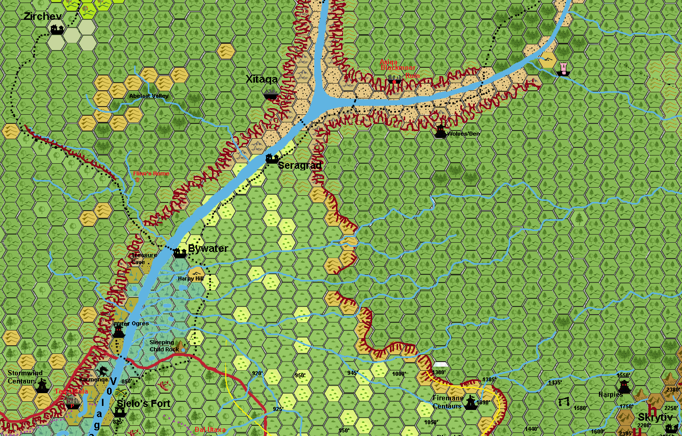
The text to read to the PC's on page 19 &20 follows the map given there to some degree.
Strange rock formation resembling a sleeping child and a pond and a faint trail leading into the woods surrounding the glade, small sunlit glen on top of a hill, variety of trees surround the glade, --is the environmental information gained from this.
Reflecting this to the X1, Gaz1, B10 maps. The pool is placed just within the northern edge of the woods
To make all the maps fitting the two southern hills/rock on the DMR1 map has to be converted back to B10/X1/Gaz 1/Penhaligon Trilogy(PHT) map information; meaning the SE rock becomes grasslands and the SW rock becomes moor (as the Gaz1map and even the PHT maps reveal this as an Northastern extension of the Kelvin Moor.)
The 2nd location on the DMR1 map (harpy hills/lair is a single hill described as such in the text, yet it lies on the edge of the moor as per Gaz1/B10 map
The DMR1 map has more flaws as the Northern Rocks are according B10/X1, Gaz1 a singular cliff, hence the redline becomes the top of this cliff. as the DMR1 also speaks of a ford to the otherside, while PHT state the same to the hillands NW of Bywater. This reveals the DMR1 as the opening between the two northern rocks and is further supported by the PHT sources.
And also makes the compas orientation of the map Nort being to the top of the map
Following the DMR1 map further we have Bywater at this ford. (the extra Bywatermap of this adventure does only vaguely resemble the original PHT Bywater map, and has even the current totally off ; it is actually the otherway around going from right to left ie; ne to SW.And the river is NOT the Castellan River but the Volaga/Highreach River, as can be seen from theGaz1/B10 and PHT maps.
Following the DMR1 map further the trail follows the river upstream on the southern shore. The DMR1 text reveals this as foothills while the gaz1/X1, B10 map reveals these as graslands; best to make these grassy hills so both canon sources are correct. The greenery/bushes spoken on page 26 is a very local set of bushes and no need to map.
Then there is a fan addition Sturm's 3.2 mile hex map) Seragrad. As it is not mentioned on the canon sources, I deem best to move this away from the trail, so it does not conflict canon, yet still adds to the map.
The B10 map reveals the cliffs at the Volaga Castellan river merging (where on the otherside of the river also the ruins of Xitaca are located hidden in the steep cliff crevaces). The trail goes along the edge of the eastern cliff passing the wolves den of B10 map, leading to the ruined tower of DMR1
The orc attack is of a small group of orcs, possibly the Yurilivsky orcs from Sturm 3.2 mile hex map. and might be relared to the same orcs of the PHT map in the "orc attack"marked location. They might also belong to Greastongues's tribe yet this may be the same as Sturm named.
The trail continues along the B10 cliffs and the Volaga River locating the Wizard's tower of DMR1 at its end.
All in all the section has become as followed;
I will insert this section in the main map later.
My opinion on the DMR1 author(s); they have minor knowledge of Mystara/Karameikos, nil knowledge of B10, and probably has not even read PHT (or only skimmed it). The knowledge of orientation and mapping is way off the canon sources. Rivers flow different directions, are straightened, wrongly named, hills are placed as if logs were dropped and all detail of earlier sources is mostly ignored.
The artist of the PHT maps has used the Gaz1 and probably the X1 maps, (as the light forests and forested hills of the Gaz1 readjusted and Gaz1 are not used but the grasslands and bare hills are used instead.) The problem with these maps is that they resemble the canon foundation of X1/B10, yet placement of locations is hard.
To the Gaz1 and Gaz1 readjusted maps the following; the X1 map had a 6 mile hex, and gave the map great detail. The B10 map of 3 miles brought even more detail, and was the first were the Kelvin Moor was mentioned. The graaslands were were they had been on X1. The Gaz maps use another scale of 8 maps, and hence removed a heck of a lot of details used in X1 and B10, yet it place the Kelvin Moor, and brought more detail. however, the grasslands of X1 and B10 were suddenly lightforest, and many hills were forested hills. The graas turning into lightforest is a clear mistake. The detail missing due hexscale variation is something totally overseen, especially as this 8 mile map was used by both canon anmd fanon hence on. and just proagated the mistakes. Detail of valleys, river flows had been altered and just on later maps as if right were actually flawed....how great these maps are...but still.
The Gaz1 readjusted was based on gaz1 and actually only increased the amount of forested hills, with again some river shifting.
The fanbased maps of 3.2 miles per hex tried to bring mor detail where based on gaz1 and/or gaz1 readjusted , and while trying to bring more detail...they had not used the x1 or B10 maps (as Sturm acknowleged) to return to the original detail and created detail on their own imagination.
The greatest problem thus in these maps is again a river shifting, and mistakes of the valleys and mountains as per X1.
Fan maps going even further, increased these flaws even further. a clear example are the location size and shape of the Lake at Threshold and the rivers and hills close to Kelvin. no source is equal the Threshold lake especially not. the B10 source gave this lake a small surface, while later sources increased its size. as the only detail map of this lake is the redboxed map of threshold revealing the lake's southern edge, either source seems to be flawed and right in this case.
I hope my work here on this will illuminate/clarify and merge this without too much disruptions on either source.
Even though this map(section) will receive more details like altitudes, and such later, it can already be used in the DMR1 adventure to replace the map given there and being compatible with the canon sources and fanon sources.
See also Thoughts about Bywater.