
Mapping Wetlands
by Sven JeskeI use three different categories in my maps:
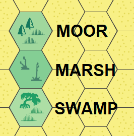
Now, this is not chiseled in stone, (and definitely not scientific at all), but roughly I use them as follows:
MOOR is found in highlands and colder climates - think Scotland, they have lots of this. May, or may not, have evergreen vegetation.
SWAMP can be found in the warm to hot climates; think mangrove swamps in southern Florida.
MARSH is somewhere in between.
Now, in a second perspective, I use it as an indicator for "danger level" ... that is, in a Moor area, I may designate the innermost and therefore most dangerous parts as "Marsh". And in a Marsh area, the innermost and most dangerous parts may get the "Swamp" symbol.
And in a third and totally unrelated perspective, I am trying to make the map somewhat aesthetically looking ^^