
Adding details to the Crossdawn Road, East Portage and West Portage
by LoZompatoreI share my own view of the Crossdawn Road between East Portage and West Portage (and surroundings). I feel that the whole concept of a long caravan slowly pulling a seagoing ship over a cross-empire road in a bandit-infested land is nothing short of awesome to let players have some fun in this part of Mystara.
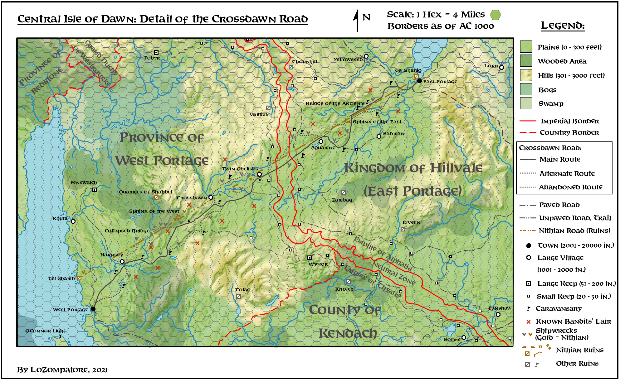
So, here is a more detailed map of the whole route, with the addition of several elements to add details and ideas useful for creating adventures and one-shot events.
The map below is sort of an experiment of mine, to see if if was possible to quickly create a realistic-looking map, at the same time conveying more details with respect to the standard hexgrid symbols at the same scale.
Just in case you are curious, here is how I created this picture (with GIMP).
First of all, I wished to keep things simple and just stole from real world maps. :mrgreen:
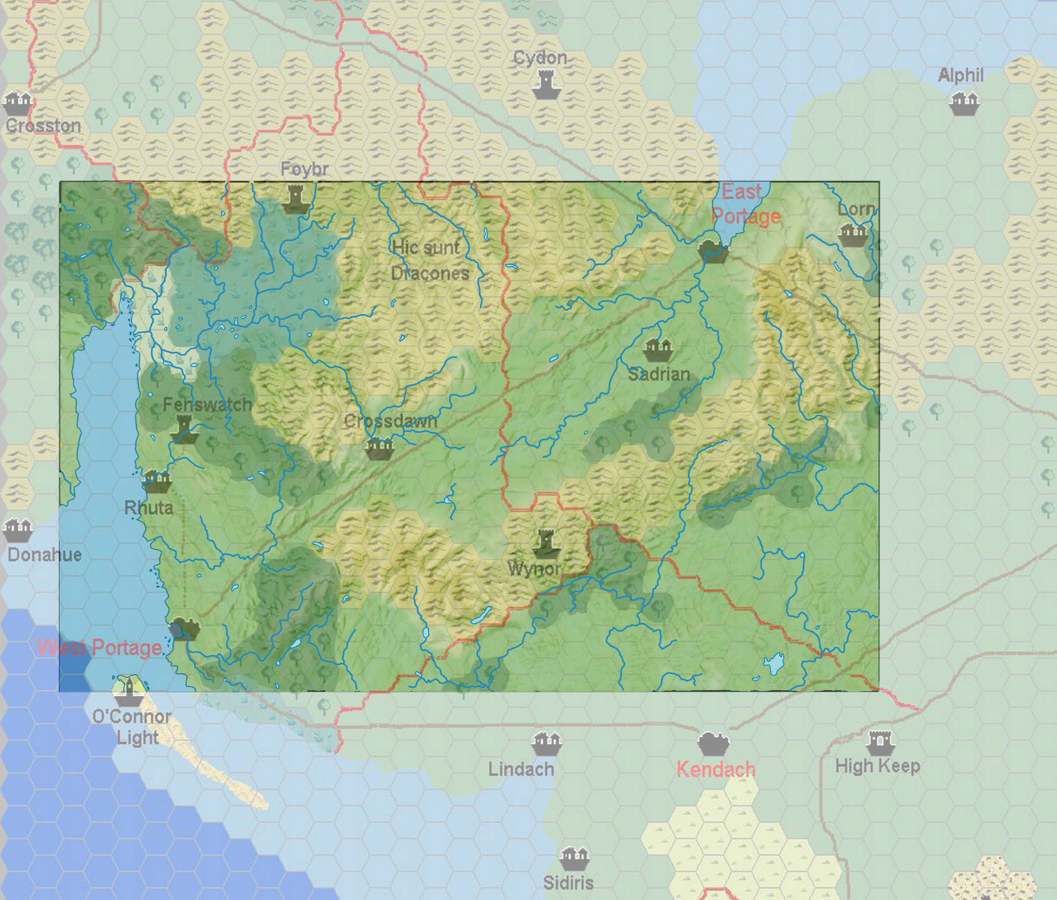
The basic elevation layout of figure above was made by copying/pasting selected hilly and flat areas from a random physical map of Wales (any other digital real world map showing a mountainous region should work as well ;)). The clippings were then arranged / rotated to match terrain from an excerpt of this 8 miles/hex map by Sturm, as you see in the comparison below:
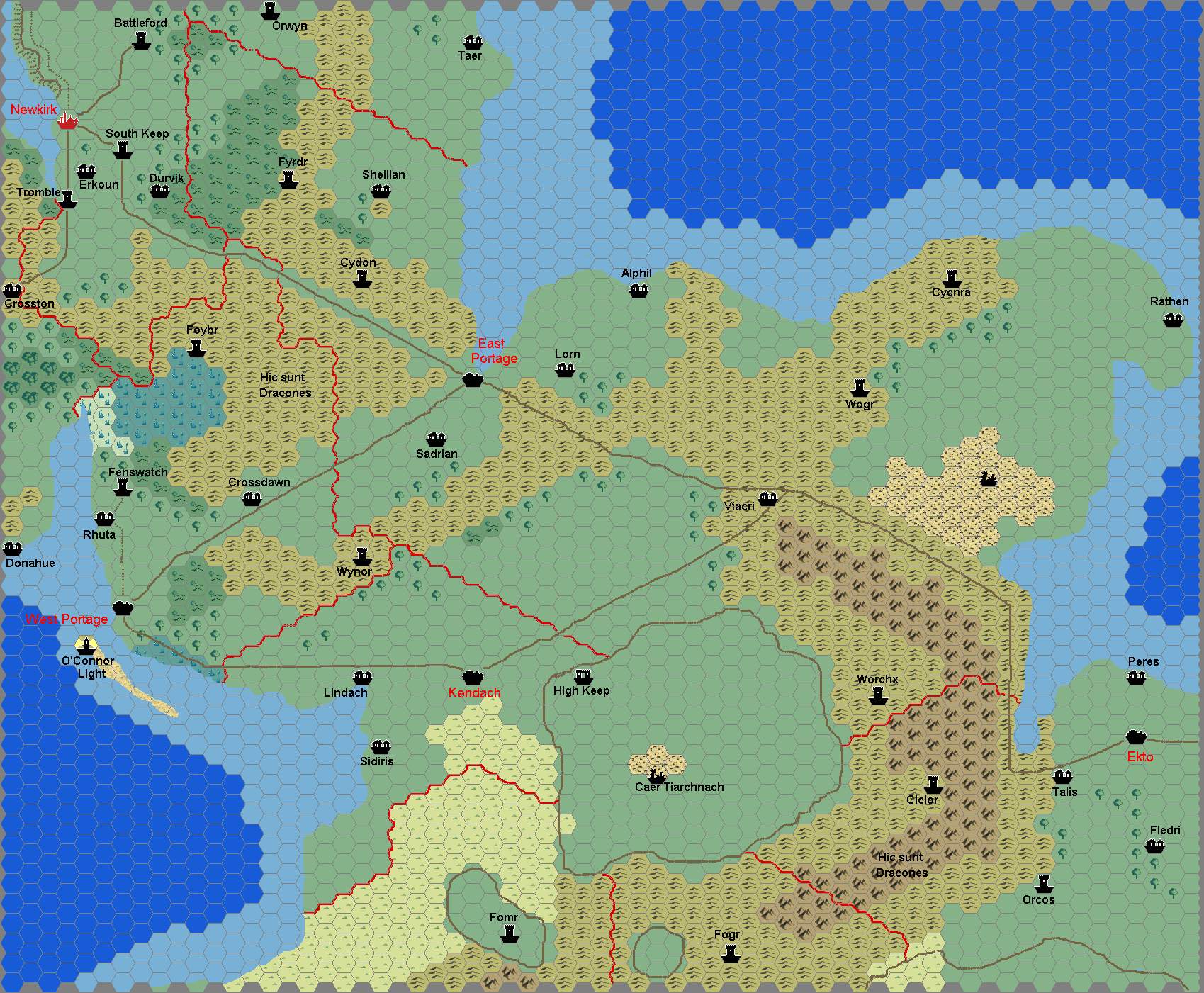
Once the whole area of interest was covered with clippings I used the "smudge stick" tool on GIMP to remove irregularities and sharp borders. It works well if you set a brush size around 5 points and move the stick on both sides perpendicular to the irregularity, trying to round smudges and keeping the original shaded areas as much as possible.
Rivers and lakes were extracted from the clippings ("select by colour" tool, with a generous colour tolerance), moved to a separate layer and rearranged, deleted or redrawn to better suit the Isle of Dawn local geography.
Then I added other layers for settlements, ruins, roads, borders, labels, the hexgrid, etc. This part is pretty much standard mapmaking, with the bonus of having some fun in drawing roads and borders wich avoid (or follow) natural features and elevations.
Finally, forested areas, bogs and the swamp are just other demi-transparent coloured layers following the same borders of the 8 miles/hex Sturm's map.
I selected an hexgrid of 4 miles/hex as a compromise between a very detailed map and the need to show in the same picture the whole 150 miles-long Crossdawn Road.
It took me around three days to complete the whole map, including all additional layers, from scratch.
I leave the GIMP file available for download here (zipped, around 11 Mb) in case you wish to edit/customize the map. Feel free to modify it as you please. :D
Said so, let's go back to the Crossdawn Road.
Canon details about the region are sparse but congruent and summarized as follows:
1) The route connecting West Portage to East Portage is called "Crossdawn Road" in TM2 map and represented with the "Road" symbol. According to a table in TM1 the trails on the Isle of Dawn are of "Fair" category while roads are of "Partial" category, meaning that only sections of the Crossdawn Road ending or starting at settlements of 15'000+ people are paved, while the rest of the route is treated as a Good Trail. According to TM1, a Good Trail is large enough for 12 horses abreast, and bridges (or easily fordable rivers), water sources, minor caravansaries, taverns and camping sites are common. The road is patrolled 1-2 times a day. A caravan of any kind and size may be met 1-2 times a day.
2) Large amounts of goods and small to medium-size sailing ships are moved along the 150 miles-long route between East Portage and West Portage (DotE DM's manual pages 71 and 72, DotE Player's Guide to Alphatia page 11, VotPA Part 12 pages 41 and 43).
3) The Crossdawn Road is described as a "trail" in DotE (pages 72 and 73) and M5 (page 45), while the end section of the road crossing East Portage from the gate to the sea is paved (VotPA Part 12 page 43). Compare also with point 1) above.
4) Most of legal trade between the Empires of Thyatis and Alphatia takes place on the Crossdawn Road (DotE Player's Guide to Alphatia page 11)
5) As of AC 1000, the dominion shown on the Alphatian side of map above is a Kingdom called Hillvale (or Highvale in a map of the Isle of Dawn shown in Dragon Magazine #165 page 44, but again called Hillvale on page 102), as per DotE page 72 and the abovementioned Dragon Magazine issue. Following the events of the Wrath of the Immortals the king surrendered to Thyatian armies in return for Ducal status in the Thyatian Empire (see for example PWAII page 97).
6) As of AC 1000, the dominions shown on the Thyatian side of map above are a Grand Duchy (Westrourke) a County (Kendach) and two Provinces (Redstone and West Portage) as per DotE pages 72-73 and Dragon Magazine #165 clarifications (page 102). During or after the events of the Wrath of the Immortals Redstone status is changed to County and West Portage status is changed to Barony (see for example PWAI pages 71 and 88).
7) A ship can be unloaded in East Portage or West Portage, its goods moved to the other town by caravan along the Crossdawn Road and then loaded on another ship of the same line (M5 page 45, DotE DM's Manual page 22, PWAI pages 29 and 88).
8) The cost of carting goods on the Crossdawn Road as described in point 3) above is greater than the cost of shipping the same goods around the Isle of Dawn between East and West Portage, but it saves time (PWAI page 88 and DotE page 70) and is safe from pirates and bad weather (M5 page 45). Eastbound fees are higher then westbound ones due to West Portage politics (and intrigue) with bandits (see M5 page 45).
9) Movement of seagoing ships across the Crossdawn Road is described in VotPA Part 12 (pages and 41 and 43) as follows: "Several medium-sized ships were being pulled out of the water and loaded onto large wooden cradles. Scores of logs placed ahead and under the ships allowed the massive hulls to move forward, pulled by hundreds of draft horses. The ships were to be slowly dragged 140 miles overland in this manner until they reached West Portage, on the opposite coast of the narrow Isle of Dawn.... Elephants and a number of other large creatures were also used as draft animals, depending on the ships. Heavily armed caravans lead the ships, often followed by impressive baggage trains and other travelers."
10) Goods reaching East Portage from the west are usually moved to Ekto-Trikelios-Edairo, or Dunadale, or Aasla (DotE page 22). From GAZ 9 trade map Dunadale imports Tea, Coffee, Ivory, Grain and Vegetables, Glassware, while Aasla imports Preserved Fish, Monsters, Rare Books, Precious Metals and Silk. Ekto exports Steel (M5 page 45, DotE page 70, PWAI page 29) and Trikelios exports Ships (M5 page 45, DotE page 70, PWAI page 85). Both of them likely exports Grain and Vegetables (PWAI pages 29 and 85) but their imports are unknown. Thothia likely exports food (Rice and Wheat, see PWAI page 80) but its imports are unknonw.
11) The whole Province of West Portage has poor farming land (PWA I page 88) so it likely imports any kind of food.
12) The Guilds of Minrothad handle silk trade through West Portage along the Crossdawn Road (to Aasla, see point 7) above), according to DotE page 73.
13) The whole Crossdawn Road is infested with bandits; many of them are secretly controlled by the townsman of West Portage and the local Thieves' Guilds (M5 page 45 and DotE page 73)
14) "Short border wars often break out between Westrourke and Dunadale, or East and West Portage; on the few occasions of all-out war on the island, every Thyatian city will fight every Alphatian city." from DotE page 74.
15) A neutral strip of no-man's-land separates the Empires of Alphatia and Thyatis between the dominions of West Portage and East Portage (DotE page 107).
16) Cults of fanatics of ancient Thothian (Nithian) overlords (dead or undead) exist in East Portage (VotPA part 12, pages 43-44).
17) The king of East Portage has friends among Thyatian merchants so he is closely guarded by the Alphatian crown for fear of treason (DotE Player's Guide to Alphatia page 11). Compare also with point 5) above.
Taking all of this into account I added the following remarks and details to the region:
A) The ancient Crossdawn Road of the Nithians:
Elaborating on quote 16) above it looks like that there was a Nithian settlement close to modern-day East Portage. This likely implies that an analogous settlement close to West Portage also existed, and also some kind of road connecting them. Let's say that such a connection made sense only some time after the establishment of the large colony of Thothia, to ease trade and transfer of people with the metropolitan territory of Nithia. Let's say that the ancient Nithian Crossdawn Road was established around BC 900.
According to HWR2 the Nithians commonly used hover-chariots and hover-boats to swiftly move bulky goods and troops over water and land (se HWR2 Player's Manual page 46 and DM's Manual page 35) but, to properly operate, these levitating vessels must be in range of a Nithian pyramid to collect its mystical energy as motive power.
Here I assumed that, instead of pyramids scattered in the wilderness all along the road, the Nithians actually made the very stones of the road able to collect Pyramid Magic, delivering it to the hovering vessels. This had the double advantage that only Nithian vessels were able to use the road at the maximum possible speed, and that the Nithian vessels on it cannot deviate from the limestone path without plummeting to the ground and crashing. This solved potential issues like mutiny or hijacking along the route.
So the Nithians used powerful magic to build a straight road of limestone slabs connecting two coastal settlements not far from the current towns of West Portage and East Portage. Elegant, single-arch stone bridges crossed the major rivers of the area, while three major landmarks were built along the route:
- A couple of high obelisks at mid-route
- The statue of a sphinx facing west quarterway on the western leg of the route
- The statue of a sphinx facing east quarterway on the eastern leg of the route
All stone necessary to these constructions was taken from the Quarry of Shabhet, on the western side of the road.
I named the two settlements to the western and eastern coasts Tel Gharib and Tel Shariq, respectively. I assume these were actually Asyian settlements, connecting them to my Nithian Mandates theory (available here), but feel free to assume they are proper Nithian towns if you like.
I assume that the whole 160 miles-long straight route from one coast to the other could be crossed by a floating ship in 4 days, for an average ship speed of 40 miles/day, i.e. slightly faster than a riverboat (36 miles/day as per Expert Set) and way faster than a land caravan (from GAZ11 speed ranging from 30 miles/day for unloaded camels to 9 miles/day for fully loaded draft horses). Ideally, a floating ship would be able to move from a landmark (sphinx / obelisks) to the next one in a single day of travelling.
With the Fall of Nithia, the Spell of Oblivion cast by the Immortals depleted the magical power of the limestones, which reverted to their natural status. The Spell caused earthquakes, landslides, floodings and other natural disasters along the route, disrupting the continuity of the Nithian Road in several points. The limestone slabs themselves cracked, sank into the ground and tilted, so most of the route is not suitable for travelling anymore. The coastal towns were destroyed and are now abandoned places infested by undead and dangerous constructs - especially Tel Gharib, which is carefully avoided by everyone. Even the old Quarries are an infested place by now.
Currently the Nithian Road is mostly abandoned, the only notable part still in use being the Bridge of the Ancients, a long, intact bridge crossing a major river some 25 miles from East Portage.
Half-buried Nithian wrecks (mostly scraps of metal, glass and stone-like materials) of a large convoy of hover-barges (some say of military use) can still be found in the woods close to the Western Sphinx monument. Explorers say the area usually looks deserted but it may show unpredictable sparks of magical energy and sudden appearance of eldritch creatures.
It is currently unknown if the three monuments along the Nithian Road possessed any magical power and if this power can be awakened in the present time.
B) The imperial border between Thyatis and Alphatia
Given the somewhat common occurence of border clashes (quote 14) above) and the establishment of a neutral zone between the dominions of East and West Portage (quote 15) above) I assumed that - despite the distance from major settlements - the whole border is highly militarized.
Along both sides of the neutral zone there would be a set of small keeps and watchtowers placed at less than a day of riding from each other, connected through well-maintained trails. Such wood and stone keeps would be expendable, easy to rebuild (and be destroyed to prevent their capture by the enemy) and manned by small garrisons of 20-50 people who patrol the surroundings, counter small enemy raids and are able to put up some resistance while waiting for reinforcements fom nearby keeps.
I placed some 15 small keeps on each side of the border between the Province of West Portage and the Kingdom of Hillvale, for a total of 550-650 people on permanent garrison duty on each side.
The width of the neutral zone would be between 3-4 miles (on arduous terrain) and 8-10 miles (on roads, rivers and other accessible terrain) to give the watchtowers time enough to dispatch messengers to the interior in case of attacks.
The whole neutral strip is devoid of settlements and is not crossed outside of established roads, except during skirmishes (so it is a haven for wild animals and monsters). Even bandits avoid hiding in the neutral land because of the risk of being detected and mistaken for an enemy force by both sides.
Ironically, the cross-border leg of the Crossdawn Road is the safest of the whole route, due to the many eyes carefully watching this sretch of land and its travellers.
Quote 14) above says that border wars are common also between Dunadale and Westrourke, so I assume that the neutral strip extends all along the border up to Helskir and, basically, also to the southern part of the imperial borders between the County of Kendach and East Portage, where a second major crossing (but secondary with respect to the Crossdawn Road) between Kendach and Ekto is established. I added at this crossing a couple of large, fortified villages (Solime and Panshaw) facing each other across the border, and two strings of grouped keeps.
I assume 10 small keeps on each side of the border between the County of Kendach and the Kingdom of Hillvale, for another 350-400 people on permanent garrison duty on both sides.
The neutral strip is probably not necessary along the Scar Mesa, where the different elevation between the Alphatian-controlled plateau and the Thyatian-controlled plains makes for an impassable barrier in itself. South of the Scar Mesa the borders of the two empires finally separate and the unclaimed wilderness of the Great Escarpment stands between Thyatis and Alphatia.
I placed some ruins on both sides of the borders. Most of them are of large keeps or fortresses, built in previous centuries and then destroyed by the enemy in past wars, before the cheapest and more practical standard of the small expendable keeps took place to cut costs and losses. The last operational survivor of the old age would be the fort of Wynor in the Province of West Portage, thanks to its impregnable position in the hilly wilderness.
C) The current Crossdawn Road:
Following the Fall of Nithia the Alphatians, who took Nithians' place in the Isle of Dawn, did not see the need to rebuild the Crossdawn Road, for there were no true civilized lands on the western continent and the northern settlements of the Isle of Dawn could be easily reached through Dunadale. For centuries, the central part of the Isle of Dawn was just a sparsely populated wilderness.
Only around BC 200 the Alphatians, wishing to stop Thyatian piracy and to conquer their gold-rich land, built the two coastal settlements of East Portage and West Portage and the Crossdawn Road linking them, on a more or less parallel route to the old Nithian Road.
Oblivious of the old magic of the Nithians, the Alphatians resorted to conventional caravans to move goods and armies to Thyatis. After some trial-and-error, the first ships were crossed in that very years, to quicky assemble naval forces in the Western Sea of Dawn bypassing Thyatian pirates operating in the Strait of Helskir.
Following more than a millennium of caravan trade, bandit and monsters raids, border skirmishes and diplomatic treatises, the current Crossdawn Road is now more like a bundle of alternative paths than a single route. The busiest path shifts over time and, while it is usually the safest to cross, caravans often opts for alternative routes to cut travel times, avoid bandits, bad terrain, rival merchants or unwanted checks from authorities.
According to quote 1) above, caravansaries are placed along the routes, on average every 20-25 miles from each other. Light caravans of mules, camels and even elephants may hope to reach a caravansary at the end of every day of travelling, while burdened convoys (including all ship transport caravans) or those made of slower animals (draft horses, oxes) usually need 2-3 days to cross the distance between caravansaries. Due to the need to accomodate the large caravans carrying ships (see below for details) such caravansaries are not small, they are fortified and usually host a garrison up to 100 people.
As made clear by quote 13), bandits infest the whole Crossdawn Road, many of them under the payroll of the Thieves' Guilds of West Portage. I placed 13 bandits' lairs along the main route and its branches (more lairs are on the West Portage-controlled area) but several others may also exist; such lairs would include at least some dozens of people to be effective against large caravans. When attacking armored caravans carrying ships at least 150-300 bandits are needed (see below) so some lairs must be very large (small villages, actually, with relatives of the bandits living inside) or allied among themselves to perform joint raids.
When caravans moving ships suffer a major accident or are successfuly ransacked by bandits it is possible that the ship's wreckage is left abandoned in place. I added several of such wreckages (of ships of all sizes) along the Crossdawn Road and its secondary paths. Such wreckages are slowly weathered down and dismantled by travellers looking for wood or logs and usually disappears within some decades, in the meantime becoming a landmark of the route. A wreckage infested by monsters or undead is avoided by most so it tends to last longer, usually more than a century, and treasures or valuable items may still be found within.
D) Traded goods along the Crossdawn Road:
From quotes 2), 4), 7), 10), 11) and 12) it looks like that almost any kind of goods are moved on the Crossdawn Road, as it is the major commercial route between the two empires of Thyatis and Alphatia. Likely the only items not explicitly traded are weapons, armor and other military equipment such as warship or good riding horses (but small quantities of these forbidden goods may be smuggled anyway). I assume that raw materials used to build weapons (i.e. steel from Ekto and good quality wood from Minrothad) and "logistic" items like draft horses from Thyatis City are traded without restrictions, as involved merchants may always pretend that such goods will be sold to civilian buyers "for peaceful purposes only".
Perhaps slaves may be also traded between the two empires through the Crossdawn Road, possibly as a way to bring back Thyatian and Alphatian prisoners of war to their own countries, but I think that such caravans are pretty rare and should follow some kind of political agreement.
An educated guess of some notable traded goods on the Crossdawn Road may be as follows:
From West Portage to East Portage:
- Silk (not Spider-Silk) from Thyatis City to Aasla (controlled by Minrothad middlemen)
- Rare Books from Surra-Man-Raa (Ylaruam) and Verdun (Minrothad) to Aasla and Edairo
- Precious Metals from Surra-Man-Raa (Ylaruam) and Ierendi to Aasla and Ekto
- Monsters from Surra-Man-Raa (Ylaruam) to Aasla
- Tea and Coffee from Tel Akbir or Minrothad to Dunadale
- Oil from Ierendi to Edairo
- Ivory from Athenos (Darokin) to Dunadale
- Glassware from Athenos (Darokin) and Jaboor (Ylaruam) to Dunadale
- Preserved Fish from Minrothad and Ierendi to Aasla
- Horses from Thyatis and Cubia (Ylaruam) to East Portage (for selective breeding)
- Common Metals from Kerendas and Specularum to Ekto
- Precious Wood from Verdun and Seahome to Trikelios and Edairo
- Alphatian and Alasyian Ships (loaded with trading goods) wishing to avoid Ostland and the Strait of Helskir
- Crippled Alphatian Ships (loaded with trading goods) moving to Trikelios for repairs
From East Portage to West Portage:
- Steel and Precious Metals from Ekto to Thyatis City
- Gems from Dunadale and Aasla to Thyatis City
- Spices from Aasla to Thyatis City
- Lacquered Tables from Aasla (Alphatia) to Minrothad (from GAZ 9)
- Common Metals from Aasla and Ekto to Stronghold (Minrothad)
- Rice and Wheat from Edairo to West Portage
- Grain and Vegetables from Ekto and Trikelios to West Portage
- Fine Porcelain from Dunadale to Ochalea
- Dyes and Pigments from Edairo and Helskir to Tel Akbir and Kerendas
- Horses and Elephants from the Alphatian Empire to West Portage (for selective breeding)
- Known World and Alphatian Ships (loaded with trading goods) wishing to avoid Ostland and the Strait of Helskir
- Newly-built civilian Ships (loaded with trading goods) from Trikelios to West Portage
E) Movement of Ships along the Crossdawn Road:
The current method for ship movement on the Crossdawn Road is well detailed in quote 9) above.
To estimate the size of the caravan needed to move the ship an evaluation of the total weight of the ship itself is mandatory.
Let's assume that the ship is fully loaded with cargo, to maximize profits and cut down expenses, and that on board no other people are allowed other than the crew and other necessary personeel (log handlers, caravan lords, and a few bodyguards) .
Let's consider a medium-size sailing ship (something in between a small and a large sailing ship of the Expert Set), with the following figures:
- Length: 80 feet (24 m)
- Beam: 30 feet (9 m)
- Draft: 12 feet (3.6 m)
Such a ship corresponds in size to a large Caravel or a small Carrack of the early XVI century.
Typical hull thickness for a Middle Ages' sailing ship was 15-25 inches (0.4-0.65 m), say 20 inches on average. So, simplifyng the shape of the ship to a box, and assuming an average wood density of 40 pounds/cubic foot (650 kg/m3), it is possible to estimate the total volume of wood in the hull at approx. 12'500 cubic feet (355 cubic metres), for a total hull weight of 500'000 pounds (230 metric tons).
Now, let's talk about the weight of the cargo. The Gross Tonnage (total internal volume, in units of 100 cubic feet) for such a ship may be estimated with the "Builder's Old Measurement" formula (see here) and refined with values shown for this modern replica of a very similar size sailing ship (basically the value provided by the formula must be multiplied by 2/3).
The same comparison provides also an evaluation for the Net Tonnage (volume of useful cargo space only) which may be estimated at 35% of the Gross Tonnage.
This gives the following values:
- Gross Tonnage (total volume)= 204 tons (580 cubic metres)
- Net Tonnage (cargo volume)= 71 tons (202 cubic metres)
Let's say the cargo is entirely filled with medium-density goods (simulated as wood, at the same 40 pounds/cubic foot = 650 kg/m3 density used above) to account for a ship fully loaded with trading items, food and water supplies.
We get a total cargo weight of approx. 290'000 pounds (131 metric tons).
By the way, this number is very similar to the "300'000 coins" capacity for a large sailing ship listed in on Expert Set page 43 and GAZ 9 (DM's book page 25). I guess that all the ship cargo capacities shown there are actually set in pounds and not in coins. :roll:
Finally, let's add the weight of the crew (22 people + personal equipment) and the other personneel (say other 15 people), assuming 300 pounds (130 kg) per person. This leads to a total of approx. 10000 pounds (around 4.5 metric tons).
Summing the weight of the hull, the cargo + supplies and the weight of those on board we get a grand total of:
500'000 + 290'000 + 10'000 = 800'000 pounds (approx. 365 metric tons)
With this figure now established it is possible to estimate how many draft horses are needed to pull the ship along the Crossdawn Road, rolling on wooden logs.
Let's ignore for a while all the figures given in GAZ 11 (DM's manual page 21) about Draft Encumbrance, and stick to real world values (taken from this nice article here).
A draft horse may usually pull over long distances a weight placed on wheel which is equal to 1.5 - 2 times the horse's weight.
When two draft horses are used in pair they are able to pull 2.5 - 3 times their total weight.
The weight of a draft horse ranges from 1700 to 2200 pounds and more.
Let's say that, after more than a millennium of activities on the Crossdawn Road, a local breed of heavy-weigth, sturdy draft horses was selected by Thyatian and Alphatian caravaners, so let's move to the highest value in most ranges shown above.
We could assume that the local breed may weigh 2200 pounds and be able to pull up to 2 times its weight when alone and up to 2.5 times the total weight when paired.
So, a couple of Crossdawn breed draft horses may pull up to 11000 pounds (5 metric tons) of wheeled weight over long distances, of course assuming they are moving at half of their maximum speed.
This would meand that 146 draft horses are needed to pull the 800'000 pounds ship at half their maximum speed.
Now, a quick comparison: according to the 20% rule (see here), a horse can safely carry on its back 20% of its own weight (440 pounds for the draft horse described above).
So, if the 150 Crossdawn draft horses were used as pack animals instead of draft animals, they could carry a total load of 150 x 0.2 x 2200 = 66'000 pounds (30 metric tons) which is way lower than the 290'000 pounds maximum cargo of the ship.
So, for the ship to be more efficient than the very caravan pulling it, it is sufficient that 1/4 of the ship's cargo is filled with trade goods.
Notice that GAZ 11 maximum pull loads and pack loads for a draft horse are very different from the ones above: moving at half speed, GAZ 11 figures are 1500 pounds and 900 pounds rescpectively. That is, a GAZ 11 draft horse would be able to pull less than 30% of its real world counterpart, but it would be able to carry on its back double of the weight. I decided to discard such contradicting data and stick to real world values. :|
Said so, let's go back to caravan composition.
From GAZ 11 a caravaner is needed every 4 mounts and a few more wagons (and related caravaners) are necessary to carry goods and items needed by the caravan itself during its journey (these items might be carried by the ship as well but I guess it is more practical and economical to have them distributed and at hand on several wagons).
About guards we could assume 1 guard every 2-5 mounts (from this article), depending on the caravan's value. As the ship itself is quite valuable and filled with trade goods, I'd go with 1 guard every 2 mounts. Many of such guards would be mounted, while those on foot would regroup around wagons and the ship for mutual protection in case of attack. The ship itself may count as a mobile keep and it usually carries a large amount of range weapons distributed among those in it, for better defense. Ropes and stairs may be lowered to allow local guards to climb the sides of the ship and better help repelling the assailants.
Finally, there are the log movers. For them I arbitrarily assume 40 people with assigned draft horses and a few more wagons (and related caravaners) carrying the logs. Log movers would be helped by a temporary crane mounted on the stern castle of the ship to lift and load used logs on the wagons. Such logs are then carried at the ship's prow to be unloaded again.
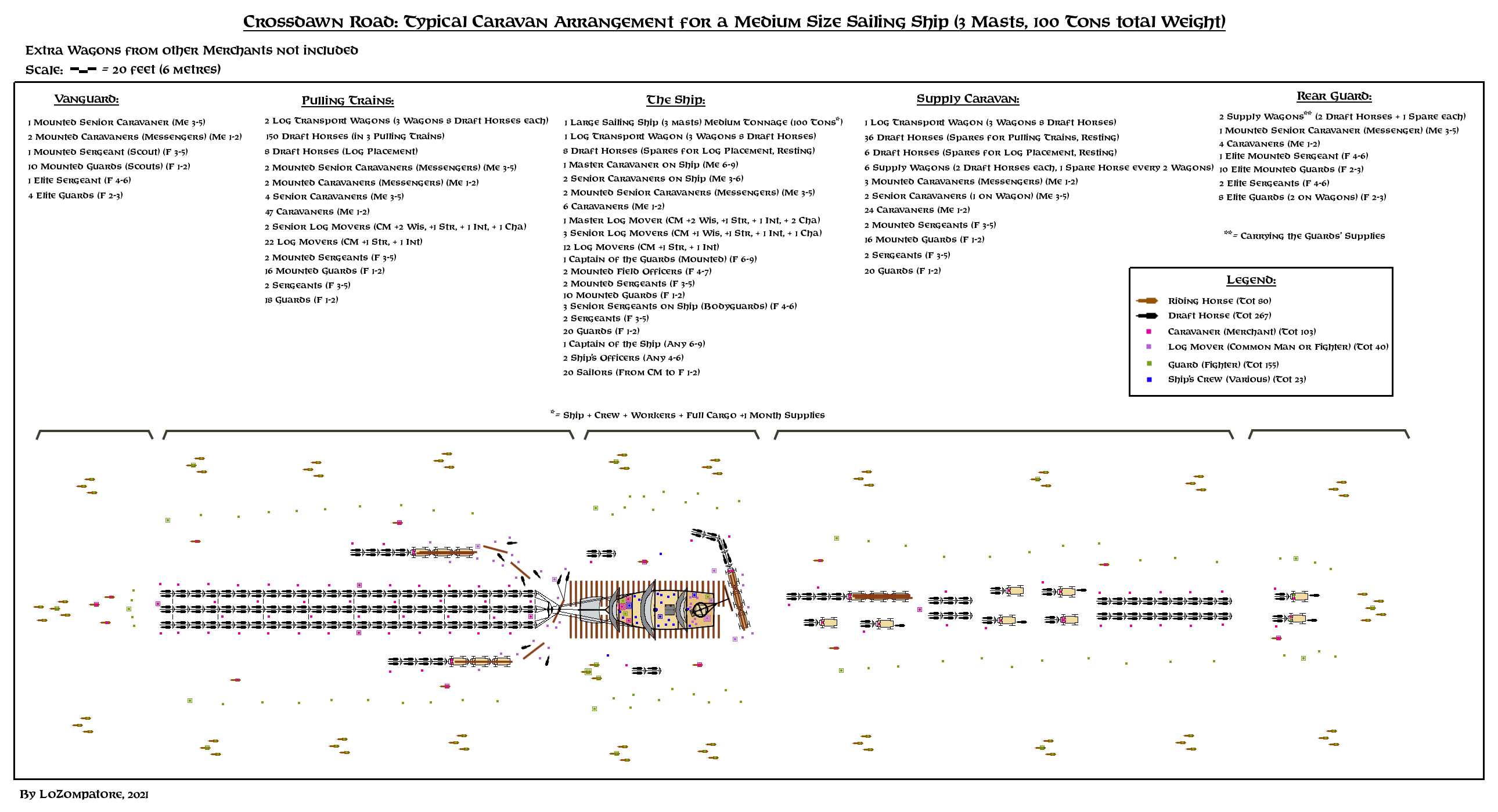
In figure below I assembled the overall caravan arrangement.
A breakdown of the caravan personneel and animals moving the medium sailing ship would be as follows:
- 80 riding horses
- 267 draft horses
- 103 caravaners (I assume they belong to GAZ 11 Merchant class)
- 40 log movers
- 155 guards
- 23 sailors and other ship's crew
F) Wages and Tariffs for ship transportation:
Without complicating things too much, I assume that guards and log movers will ask for a fixed price in GP for the journey, while all merchantmen and caravaners will ask for a share of the ship's cargo they will sell at destination keeping all earning for themselves.
The only other fixed cost is for food assigned to men and riding/draft beasts (as per GAZ 11 rules). Mainteinance of wagons and other minor expenses such as ordinary loss of draft animals and equipment are included in this entry,
Costs for guards is based on Expert Set table for mercenaries, always assuming wartime conditions due to the risks posed by the journey, and doubling, tripling, etc. the base cost of the mercenary depending on the experience level. It is assumed that, at the beginning of the journey, all guards come provided with their own equipment in excellent conditions.
Transportation of a Large Ship:
- Guards: 4200 GP (approx. 150 guards, half on foot and half on riding horses, including a commander, two senior officers, 3 bodyguards and 21 sergeants)
- Log movers: 600 GP (approx. 39 log movers and a leader, with 60 draft horses, a crane, and a suitable number of logs and wagons)
- Caravaners: 30'000 pounds of cargo (approx. 102 caravaners with 210 draft horses and 15 riding horses, including a master merchant, 2 deputies and 15 senior caravaners)
- Food: 1800 GP (for all men and horses for the whole trip including stops at caravansaries and all ordinary mainteinance operations)
Transportation of a Small Ship:
- Divide by 3 all figures above (fixed cost in GP, pounds of cargo, number of personeel and horses, keeping only the senior officals and commanders)
Tolls for the use of the Crossdawn Road are comparatively minor with respect to the cost of the whole caravan and can be neglected by assuming they are already included in the other entries.
In case you wish to add some detail when paying taxes to officers in East Portage and West Portage, I estimated the total toll by taking data from PWAII fees for the use of roads in Hule (page 163) and for the toll to be paid by a ship to cross the Girdle of Vanya in Thyatis (10 GP, from GAZ 9 page 30). Doubling the tax for the ship and rounding up all figures I got the following tolls:
- Toll for a Large Ship (including caravan) = 90 GP
- Toll for a Small Ship (including caravan) = 60 GP
These values should apply for westbound travel from East Portage.
According to M5 eastbound fees were increased by the ruler of West Portage to account for losses caused by bandits. You could assume a 33% increase to 120 GP and 80 GP respectively, per caravan.
G) Populations of the settlements of East Portage and West Portage:
From the above evaluation about the size of a single ship-carrying caravan (approx. 300 people not counting the ship's crew) it is clear that the official figures for the populations of East Portage and West Portage (1000 people and 2000 people respectively in M5 and DotE, raised to 5000 and 10000 people in PWAI) do not make any sense, especially if TM1-2 and VotPA info are taken into account (multiple ships ready to be moved on the Crossdawn Road at any given time, multiple caravans encountered every day on the road, paved road crossing East Portage).
From TM1 info common caravans are encountered 1-2 times per day of travelling (let's say 2 times every 3 days of travelling).
Assuming for the sake of simplicity that caravans travelling on the same direction do not overtake each other, and assuming an average travelling speed of 13 miles per day, then a caravan would cross the 160 miles-long trail in 12 days, meeting 8 other caravans travelling in the opposite direction. Let's add 2 more caravans not encountered because they took one of the less-traveled alternate routes. Of all of them, 3 could be caravans carrying a ship to the other coast, thanks to the advantage in total cargo capacity and to the extra defense provided by the ship. Not all the ships would be as large as the one shown in the example above; actually, most of them will be small sailing ship, with 1/3 of the tonnage and 1/3 of the caravan size (100 people each).
Notice that the fact that there are 3 caravans carrying ships at any time on a given direction on the Crossdawn Road implies that a ship is loaded on the Road every 4 days from one of the coastal cities, and at the same time another is unloaded back to the sea.
Said so, let's do some population estimates. Each of the 7 common caravans may have an average of 120 animals and 50 people between caravaners and guards, while the 3 caravans carrying ships might transport 2 small ships (100 people) and 1 medium-large ship (300 people), for a total of:
7 x 50 + 3 x 100 + 1 x 300 = 950 people (round them up to 1000) moving in the same direction at any time.
This figure doubles in order to account for travellers moving in the opposite direction.
So, at any time, 2000 caravaners and guards are moving along the whole Crossdawn Road on 20 caravans of various size and composition.
We could assume that, once in a coastal town, a caravan stops for a couple o weeks to sell goods, rest and load a new cargo. So let's double the number above to account for caravaners and guards trading, resting and waiting for their caravan to assembly in East Portage and West Portage.
For every caravaner or guard there may be 2 other people providing services to them (carriers, horse-breeders and stable hands, accountants, warehouses / trading companies middlemen, priests, inn-keepers and shop-keepers, carpenters and smiths / blacksmiths / weaponsmiths, food producers and so on) for a total of 12'000 people involved in the movement of goods along the Crossdawn Road.
Let's add their families (3 other non-working people - children and elders - per worker) and you'll get a total population of at least 48'000 people between West Portage and East Portage.
If we keep the 2:1 proportion between West Portage and East Portage then we have the following figures:
- West Portage: 32'000 people
- East Portage: 16'000 people
This result also respects TM1 note about the paved road being present only on a settlement of 15'000+ people, which is consistent with VotPA description of such a paved road in East Portage.
Once the populations of the major settlements of the region are set, it is safe to add villages with populations in excess of 1000 people in the rest of the two countries.
Due to bandits and the occasional border war between Thyatis and Alphatia, all villages shown in the map (Rhuta, Harnsey, Crossdawn, the Twin Obelisks, Aquarine, Sadrian, Yellowseed, Lorn, Solime and Panshaw) are large, fortified settlements with a population between 1000 and 2000 people. The largest ones would be those shown on Sturm's map, i.e. Crossdawn, Sadrian, Rhuta and Lorn, with a population between 1500 and 2000 people, while the others would stay in the 1000 - 1500 people range.
A small fort inside the village and a garrison equal to 10-15% of the civilian population is also assumed in all settlements. All villages have large stockpiles of food and goods stored in safe locations and accomodations for 300-400 extra pepole (including mounts) among inns, taverns, guesthouses and the local caravansary built inside the walls. All villages tend to be self-suffcient, as they may find themselves suddenly isolated or under siege by enemy armies or large groups of bandits. Villages usually provide a larger set of services to caravans with respect to caravansaries: given enough time a crippled caravan taking shelter in a village can be replenished and restored to its full operativity.