
Known World BC 2000, 8mph
by John CalvinMaps
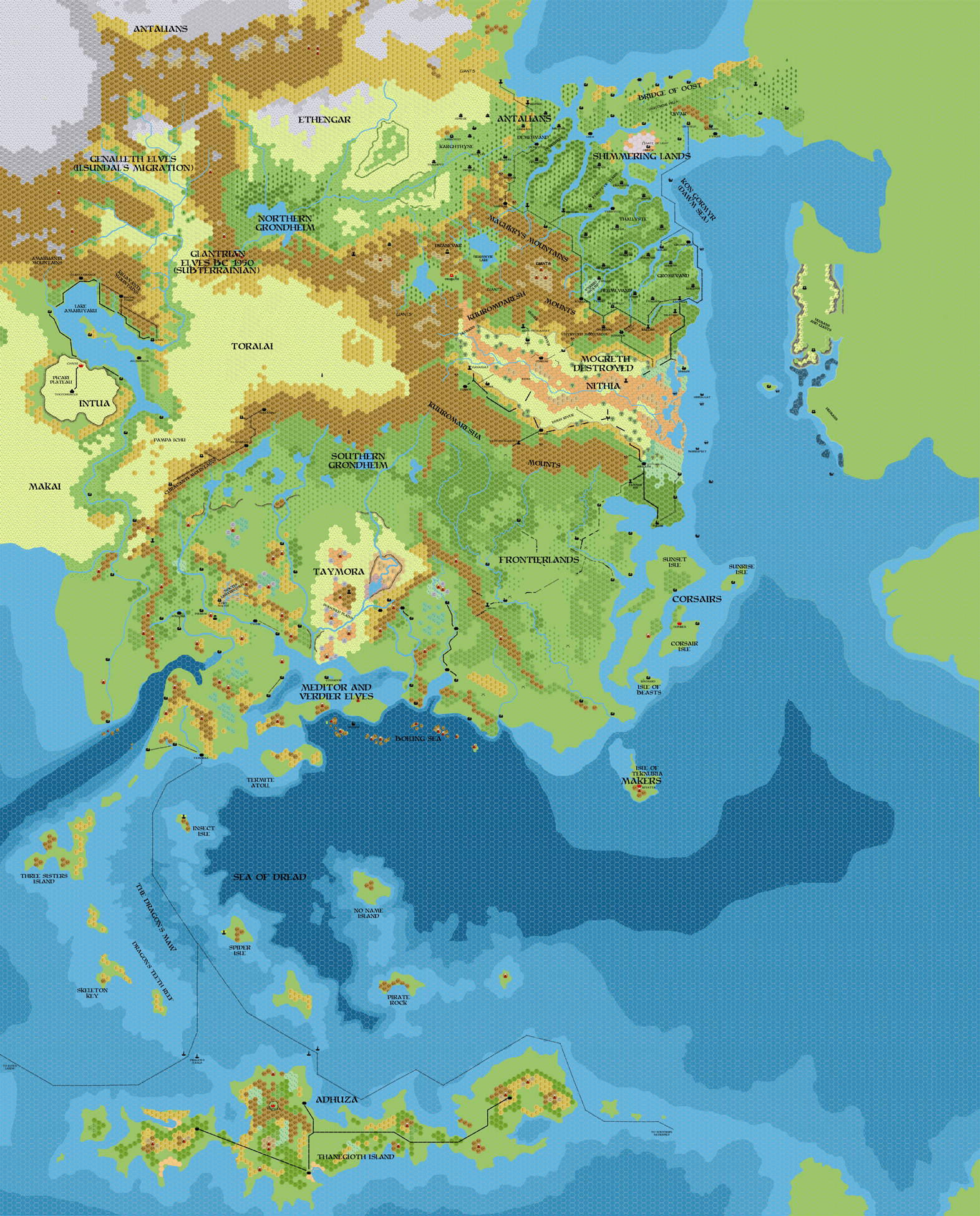
Map of the Known World, circa BC 2000, 8 miles per hex by John Calvin, September 2011 (Work In Progress)

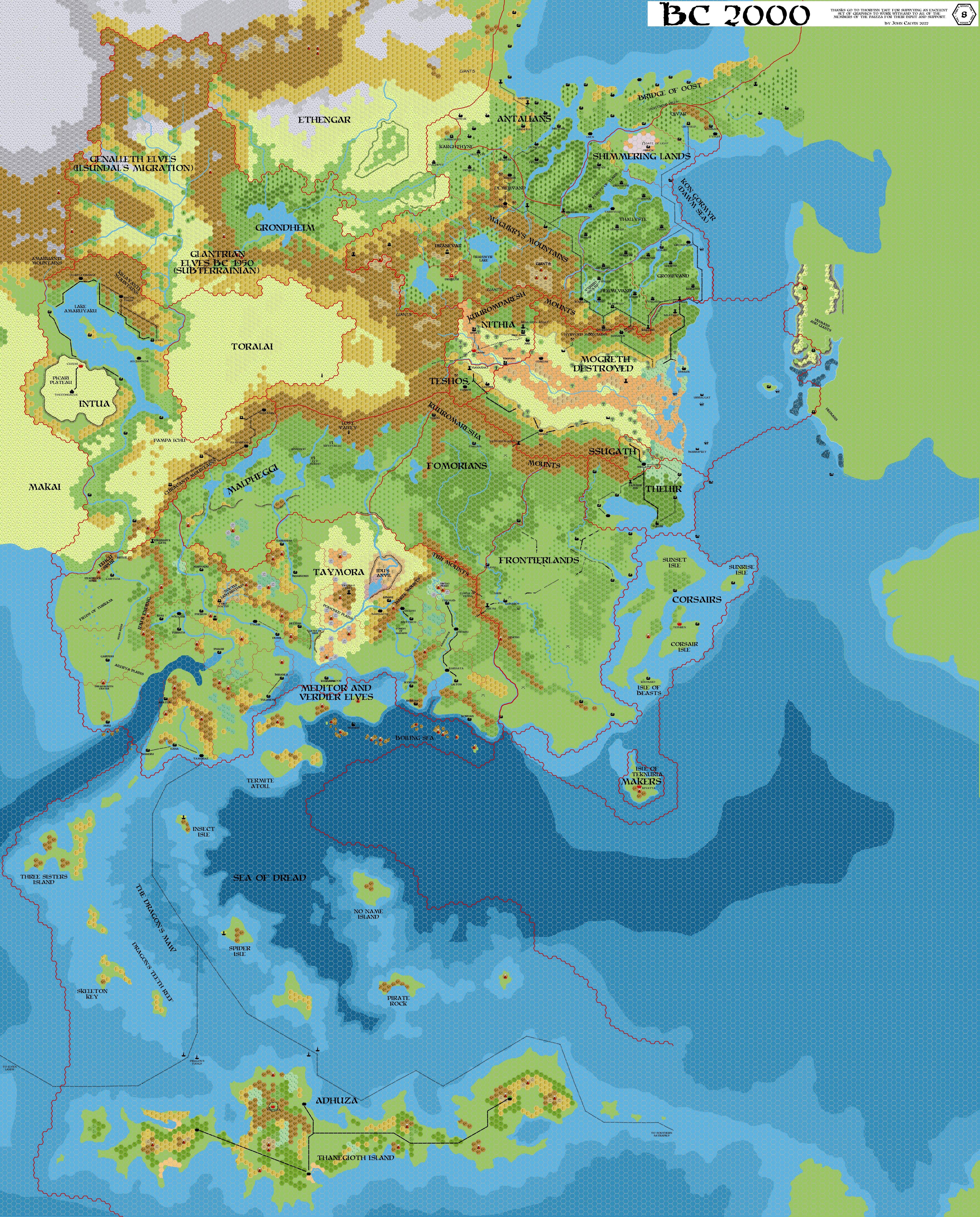
Map of the Known World with Borders, circa BC 2000, 8 miles per hex by John Calvin, Jan 2022 (Work In Progress)
Comments
1) This should be just after the time of the Mogreth Flood. Much of inland Mogreth has been swept away, but I'm not sure what I have is the best way to portray this. I do envision the landscape recovering a fair amount.
2) I've actually left the ruins of Isshum on this map. I figure it might be nice to play with those ruins for the following 250 years or so, before the event that sinks Taymora also removes the last remnants of Isshum.
3) The Great Plateau is still intact at this point - it will crumble circa BC 1750.
4) Most of the BC 2300 shoreline is still intact at this time.
5) I've also melted off some of the northern glaciers - the terrain changes may still need to be tweaked.
Sources:
References
Thanks to: Thorfinn Tait, for providing some wonderful graphics to use in all of our mapping projects, Geoff Gander for developing Mogreth, Hugin for his work on the GazH project.
Major Events
- In BC 2000, the glacial dam of Raismyr Breaks in the Shimmering Lands unleashing a torrential flood that wipes Mogreth off the map.
- Subterranean elves move into the Glantri region circa BC 1950.
Map Labels
- Adhuza - Nation controlled by the kopru
- Antalians - Nethar descendants who have been living in a harsh and cold climate.
- Corsairs - Society created from freed slaves that has turned to maritime trade and piracy
- Ethengar - Warriors and expert horsemen.
- Frontierlands - A no man’s land between Taymora and (formerly Mogreth) populated by individualists and frontier explorers.
- Genalleth Elves - These elves are the forerunners of Ilsundals migration
- Glantrian Elves - These elves fled underground during the Great Rain of Fire and have only recently decided to return to the surface.
- Grondheim (Northern and Southern) - Nation of giants and fey led by the Troll Queen.
- Intua - Descendants of the Azcans who took shelter under the Great Plateau after the Great Rain of Fire.
- Makai - Nethar tribes that have specialized in sea trade and subsistence.
- Makers - Refuge of ancient Blackmoor that escaped the destructive upheavals caused by the Great Rain of Fire who have turned to fleshcrafting
- Mogreth (Destroyed)
- Ssugath - a remnant of the recently destroyed Mogreth empire.
- Teshos - a remnant of the recently destroyed Mogreth empire.
- Theliir - a remnant of the recently destroyed Mogreth empire.
- Nithia - the fledgling human nation that is destined to be the first real empire since Blackmoor.
- Shimmering Lands - Dwarven inheritors of ancient Blackmoor
- Taymora - Nation of vampire queens and undead
- Fomorians - Giants formerly of Southern Grondheim
- Malpheggi - mostly Lizardfolk who have been expelled or fled from Mogreth
- Meditor and Verdier Elves - Forerunners from Ilsundal’s migration that have taken to the sea.
- Toralia - Nethar tribes that are known as buffalo riders