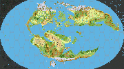
Mystara Outer World 1000 AC, 72 miles per hex
by Francesco DefferrariMystara Outer World, 1000AC, 72 miles per hex By Sturm (Work in progress)
This is a map of Mystara in 72 miles per hex. The existing canon maps at this scale were the primary source, and the map was modeled mainly on them, but could be slightly different in distances and shapes from 24mph and 8mph canon maps.
The map is sort of very imprecise Hammer projection of 360 cm x 200 cm and 360 x 200 hexes, that means than 1cm=1hex=1degree of latitude and longitude.
The 10 extra degrees north and south are inside the Hollow world curvatures.
I will eventually post other version of the map, one with latitude lines and ice caps, another with geographical names, another with cities and nations et more.
A real world latitude degree is 68 miles, roughly, so 72 miles degrees make Mystara a little bigger than Earth, 25.920 at the equator instead of 24,901.55 miles. More on this in a follow up post.
The main fan sources I used are Geoff's map of Davania, that however I enlarged much to better fit it with my idea of the continent: Geoff's map is 197x67 hexes while mine is roughly 203x84. The addakian sound position hasn't changed much but Izonda is a bit more to the west, the aryptian coast is longer and Oceania and Vulcania are a bit more to the east. And the continent is much larger obviously, mostly in the north south direction. The same goes for Kal's map, that for Davania was almost completely derived from Geoff.
Christian Constantin and Thibault Sarlat's maps of Brun were the main fan sources for the continent, from which Kal's 24mph map I think was made, but I found them a bit "short" in the eastern coast of Brun comparing them to canon 72 mph maps, so I gave precedence to the latter.
Christian's map of Skothar was the main source for the continent and I changed almost nothing of it, but I moved it a bit northern than in Kal's map to better fit it with canon 72 mph maps.
The shape of Evergrun comes from this map by LoZompatore. I included it, even if it's not present in the Hollow World planetary map, because its existence makes sense, IMO, with the position of Davania and elven history.
There would be many other things to say about the map, I'll eventually post them when they come to mind but the most important is that obviously this is just my interpretation of Mystara in 72 miles per hex, as canon sources do not help much and the issue of projection at this scale is pretty difficult. Anyway I think it could be a useful map to have a larger picture of Mystara.
Work in progress, still several things to correct..
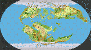
Mystara Outer World, 1000AC, 72 miles per hex with Climatic zones By Sturm (Work in progress)
This is the map with latitudes: the black lines are artic and antartic circles, northern and southern tropic and equator.
There are also ice caps, south and north. The blue line between icecaps marks where the ice reach in winter and in summer.
The "shadow" areas north and south are inside the Hollow World curvature.
I went my own way with latitudes as this canon map had inconsistent latitude degrees, roughly of 90 miles to the south and 84 in the north, meaning that Mystara should be much bigger than Earth or that the 72 miles hex is not always 72 miles. Also they do not fit at all with latitudes in this canon map where one degree should be around 60 miles and therefore Mystara would be smaller... Therefore I chose to disregard them all, except for the position of the equator as in the above map, south of Cyclonia and north of Polaktisikes. My northern tropic is right in the middle of Aegos, between Ochalea and the Isle of Dawn, and the 30N are on the southern tip of Thyatis, Alpha is 60N.
Several considerations come up seeing the map: the north tropical zone reaches southern Bellisaria and souther Isle of Dawn but only the southern fringes of Tangor, something I think wasn't considered much in official maps.
A lot of my enlarged Davania is in the southern temperate zone. The enlargement was necessary, IMHO, because otherwise the frozen Vulcanian steppes, at 50S, were not very frozen, while I have them below the antarctic circle. Also there was too much sea under Davania and it didn't seemed too big in comparison to Skothar. That probably happened because Christian's Skothar was made with a "Mystara as big as Earth" idea, while Geoff's Davania with a "Mystara smaller than Earth" as in the measure given in the HW planerary map. But I prefer a bigger Mystara
I also imagine the arctic and antarctic zones to be a bit milder than in real world, mostly for the influence of the polar openings, as hinted in this interesting article by LoZompatore.


