Size of Mystara
by Sheldon MorrisThis may be a new thread regarding an old topic, but after reviewing older threads I felt it best to start afresh as this is from a fresh perspective.
Here was my approach; how much land was mapped, and how did that fit with latitude info in canon sources?
What I found was contradictions in latitudes (my shock was intense ). At first, it appeared as though 60 miles per degree of latitude worked well. Then I looked northerly and it completely fell apart. I went back to hex counting, lots and lots of hex counting.
The PWA I map has one degree equal 84 miles, while PWA II has it equal 60 miles (thus, PWA I places Oceansend at 49°N, while PWA II has it at 63.6°N). Note that these two maps seem to hinge (agree) at where 30°N lies. From that point, PWA I pushes the equator a long way further down; 23 more 72-mile hexes from the bottom of that map, and 10 more hexes past the equator as it shows on the PWA II map (to around Aellos in the Adakkian Sound). That's 720 miles difference!
Then I got a nice surprise. Yes, an honest, truly genuine surprise. It began to appear as though the 72 mile hexes counted very well as one degree latitude. Using PWA II map's location of the equator and counting hexes:
Mivosia at hex 04 [04° N]
Caerdwicca at hex 24.5 [24.5° N]
Thyatis City at hex 33 [33° N]
Glantri City at hex 40 [40° N]
Landfall at hex 47 [47° N]
Oceansend at hex 52.5 [52.5° N]
Alpha at hex 60 [60° N]
Farend at hex 64.5 [64.5° N]
Additional counting and map cross-referencing confirms, in my eyes, that this is a very viable interpretation. But what does it result in for Mystara?
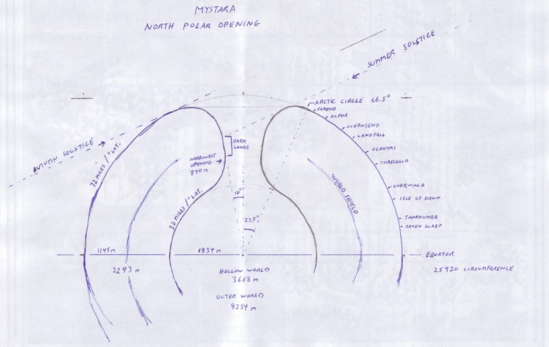
- Mystara is slightly larger than Earth (1.04 times) instead of much smaller (0.78 times); it's circumference is 25,920 miles around instead of 19,448 (Earth being at 24,901),
- The crust is much thicker at 2,293 miles across (unless the Hollow World scale is altered),
- The Hollow World (using a 40-mile hex) has 32 miles to one degree of latitude, and is 3,668 miles across from one side to the other.
For those interested in further details, here are some latitudes from examining DJ Hartel's massive 24-mile hex Eastern Brun map:
| hex # | °N | Place |
| 12 | 4° | Mivosia |
| 35 | 11.7° | Garganin |
| 39.5 | 13.2° | Tanakumba (Yavdlom) |
| 55.5 | 18.5° | Chung Tsu (Ochalea) |
| 62 | 20.7° | Isle of Dread plateau |
| 67 | 22.3° | Castle Furmenglaive |
| 74 | 24.7° | Caerdwicca |
| 97.5 | 32.5° | Edairo |
| 104 | 34.7° | Threshold |
| 106 | 35.3° | Darokin |
| 119.5 | 39.8° | Glantri |
| 124 | 41.3° | Zeaburg |
| 141 | 47° | Landfall |
| 155 | 51.7° | Oceansend |
| 176.5 | 58.8° | Alpha |
| 191.5 | 63.8° | Farend |
| 197.5 | 65.8° | Vaasa |
| 210.5 | 70.2° | ?Hyborea village? |
| 221.5 | 73.8° | Camp Avernius |
| 227 | 75.7° | ?Hyborea ruin? |
| 236 | 78.7° | top of map |
At this point, I'll be adopting this scheme for GazH project purposes.
Here's a quick and rough graphic depiction of the data I've collected.