
The Dymrak Forest Region
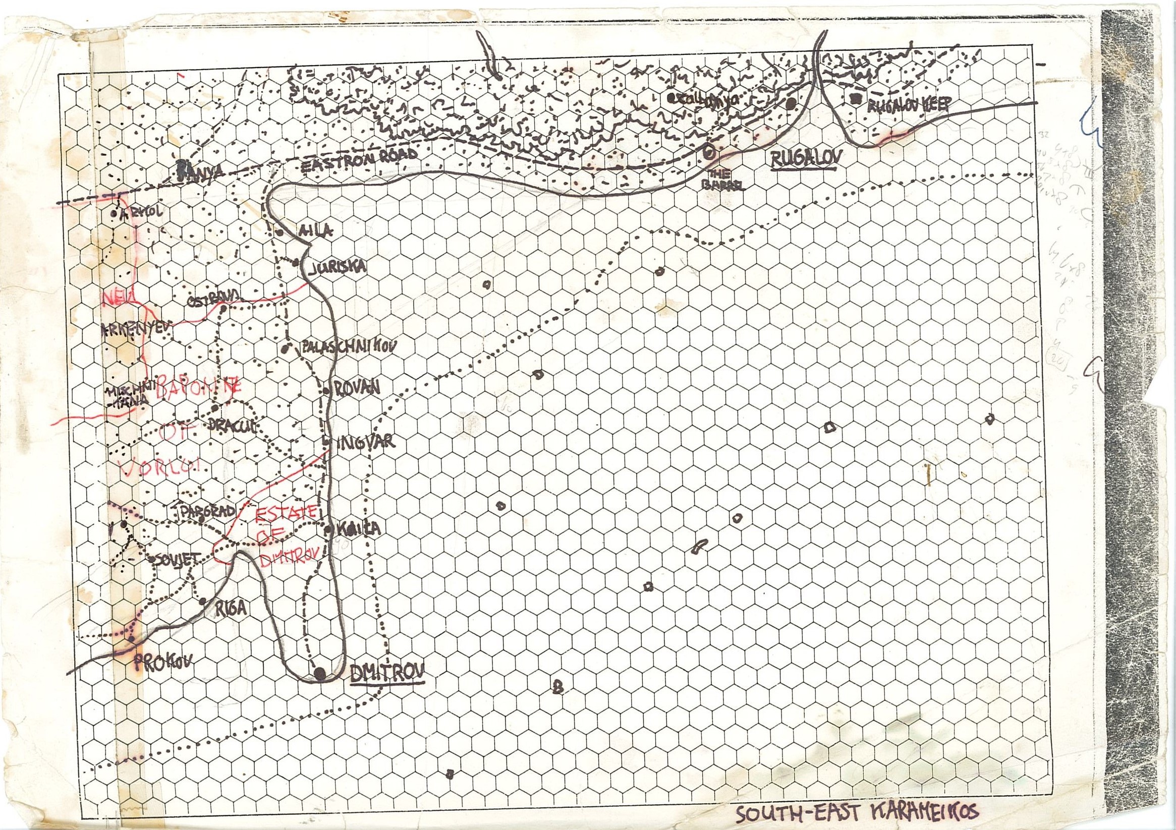
by Robin from Threshold Magazine issue 24Southeast Karameikos, the region to adventure from The Barrel.
Some words from the Author:
This article provides extensive detail on the south eastern region of the Grand Duchy of Karameikos which includes the Rugalov Estate, the Dymrak Forest, Haven and the Eastron Road. Also located in this region is “The Barrel” inn as described in Threshold Magazine #23. (See; http://pandius.com/Threshold_23.pdf)
The 1-mile hex map of the region is derived from many canon and fanon sources which enabled me to incorporate much detail and interesting locations. Sometimes unintended marks on the source maps led me to create even more detail and new sites (like the small islands, which were initially only blotches on Sturm’s map, and are now more fully detailed on the map).
Without the fan-created material I would not have been able to produce such a detailed map of the region. I must thank Agathokles, Thorf, Chimpman and particularly Sturm (for his added information here) for their past contributions.
I still desire to map Karameikos completely at 1-mile/hex scale, but this will undoubtedly take some serious amounts of time and effort. The results of this endeavour will appear in my “1 Mile Hex Mapping” topic at the Piazza Forums. (http://www.thepiazza.org.uk/bb/viewtopic.php?f=3&t=15023&start=375#p228271) Detailed descriptions of other regions may appear in the forum and/or in future issues of Threshold Magazine.
I truly wish you all enjoy great adventures in this region, visiting the various locations and finding the map of interest. Have Fun!
Robin
Encounters - Most of what is depicted here for the Dymrak Forest can be used elsewhere with ease. However, as the encounter list is tailored to the region (but usable in other regions of Karameikos) the list may or may not include creatures relevant to the campaign setting you use or may need adjustment to chances of encounter.
NPCs and Timeline – A chronology of events in the region and details of NPCs connected with the region (particularly relating to “The Barrel” inn) can be found in issue #23 of Threshold Magazine. (see; http://pandius.com/Threshold_23.pdf). Many of the NPC’s mentioned here are part of the storyline around the main characters of The Barrel.
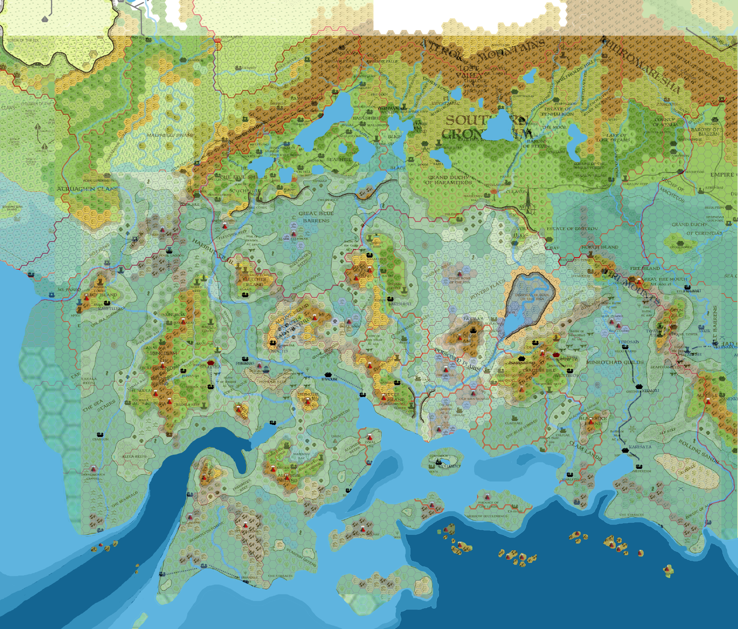
Image; Map of Southern Dymrak Forest and Rugalov http://pandius.com/dymrak_forest_by_6inchnails_ddaqgvd.png
All this is based on the greatly updated 1 mile map of the Dymrak Forest as per variant canon maps and sources and fanon additions by Robin.
Here all the original sources for making this map together; https://www.deviantart.com/6inchnails/art/South-East-Karameikos-research-788886325
Sources
B1-9; “In search of Adventure”, B10: “Night’s Dark Terror”, DDA4: “The Dymrak Dread”, X1: “Isle of Dread”, TM1: “The Western Countries Trailmap”, TM2: “The Eastern Countries Trailmap”, GAZ1: “The Grand Duchy of Karameikos”, GAZ6: “The Dwarves of Rockhome”, GAZ7: “The Northern Reaches”, GAZ9: “The Minrothad Guilds”, “Dawn of the Emperors”, “Karameikos: Kingdom of Adventure”, PC1: “Tall Tales of the Weefolk”, PC2: “Top Ballista”, PC3: “The Sea People”, PC4: “Night Howlers!”, The Penhaligon Trilogy novels (“The Tainted Sword”, “The Dragon’s Tomb”, “The Fall of Magic”) by D.J.Heinrich.
http://pandius.com/32karamp.html and http://pandius.com/nekaram.html by Agathokles (Giampaolo Agosta),
http://pandius.com/kara1020.html by Sturm (Francesco Defferrari),
https://mystara.thorfmaps.com/b10-eastern-karameikos-3/ by Thorf (Thorfinn Tait)
http://pandius.com/south_east_karameikos_mystara_by_6inchnails-dayxona.jpg by Robin
Taymora map overlay 2300BC and 1000AC http://www.pandius.com/Mystara2300BC_Taymora_Overlay_8mph.png by John Calvin/Chimpman with works of Geoff Gander, James Mishler, Giampaolo Agosta
Known world map 3050 BC http://pandius.com/New_Blackmoor_3050BC.png by Sturm
Penhaligon Trilogy inside cover maps; http://pandius.com/bywater.html
Compilation research of the area; https://www.deviantart.com/6inchnails/art/South-East-Karameikos-research-788886325 by Robin
Gazetteer of Locations on the Dymrak Regional Map
This section provides information about almost 100 locations that the author has marked on the 1-mile per hex Dymrak regional map. To assist readers in finding these sites amongst the map’s huge amount of detail, each location has a reference in square brackets after its name which relates to the grid map below, helping focus on the location of the feature.
These
locations can be further detailed by an individual DM and can have
from zero to major impact on PCs’ careers depending on the DM,
circumstances, PC choices, and NPC reactions to these situations. The
descriptions and any suggested adventures could be used as a thread
to create short interesting exploits, which might be linked together
with other adventures and canon material by a DM to make a campaign.
A, B, C, D, E [B6], [B6], [C6], [B7], [A7]
Source: created by the author, based on information in the “Poor Wizard’s Almanacs”.
Originally, these were the sites of five ground-based (without Hometrees) settlements of Vyalia elves. Over the course of many decades the villages were destroyed by goblins, or (during the time of the Penhaligon Trilogy) by abelaats. The goblins, who despise weak, foul elves, have left the sites totally abandoned with no intention of using them as lairs. The gold dragon, Giofelyll, often roams the ruins looking for gold and other items to add to its horde.
After 1009 AC these sites will be re-settled by refugees from Alfheim as elven villages of between 150 and 400 inhabitants in each. As a result, these sites will acquire new names (the originals having been lost in shame in ages past):
A
= Maelidorlaimë
(Shadow of Maelidor),
B
= Pinitel-eredh (Seed
of Pinitel),
C = Feadorhuorn
(Feador’s
Spirit),
D = Vinyalondë
(New haven),
E =
Lencanorië (Slow
Runner).
The
new names reflect the clans who have settled the old sites and also
depicts their pain and hope.
As in other Elven settlements,
Hometrees will soon be planted in the new villages, and these will
grow rapidly under the influence of Elven magic (these will take a
minimum of 2 decades to reach full size, but often several decades
more). Their propagation range will be limited to a few miles at best
(unlike the Canolbarth which encompassed a vast area and had a
special ancient forgotten magic enabling this).
The villages
maintain intense contact with each other, but have moderate contact
with other settlements in the region. As elven settlements these
sites follow the laws of Alfheim while acknowledging local Karameikan
and Vyalia rules.
In a century’s time, when Alfheim is reborn as suggested by this author in Threshold Magazine issue #10 (http://www.pandius.com/Threshold_10.pdf), these locations will be returned to nature, and will again become ruins. Uncared for, the hometrees will no longer grow and remain as they are. After a century or three they will die and often fall down. There is a chance, however, that the Callarii will take one or two of these settlements and make them their own when the Alfheim Elves have left.
Andis [E3]
Source: Sturm’s map.
This is the former Traladaran village of Siniv, a name meaning ‘Blue’ (derived from a legendary blue dragon that once lived here). In 971 AC it was settled by the Andis family of Thyatian knights and is now a mixed Traladaran/Thyatian human settlement of about 85 inhabitants. The mostly family-based population engage in occupations of farming, fishing, orchard tending, and smuggling.
The village has good contact with all other road settlements, moderate contact with off road settlements, and minor contact with Callarii Elves and Humanoids. It has a copper grade1 Inn/Tavern: The Apple Crown. Laws in the village are loosely observed. From Andis the Eastron Road runs west to “The Barrel”, 4 miles beyond which is a trail to a Shrine of Petra. In the opposite direction, the Eastron Road runs to Soprotiv (passing a ruined Shrine of Zirchev after 3.5 miles). A trail to Glucynthos leads south from Andis.
Andreas [B1]
Source: Sturm’s map.
This is the fief of the Andreas family of Thyatian landed knights. It is not an Estate, as Lord Kelvin does not allow smaller Estates in his domain, and thus it has no real military other than three family members and a few locals. Andreas is a Traladaran and Thyatian human settlement of about 50 mostly family-based inhabitants engaged in farming, fishing, and hunting, who also control logging transport to Kelvin.
The village has moderate contact with Kelvin and the Callarii elves, and minor contact with humanoids. There is a copper grade Inn/Tavern; The Wild Beaver. Karameikan law is strictly observed. From Andreas, trails run east to the Callarii/Kelvin Road and south-west to Skebos.
Apo-Meny [B5]
Source: created by the author
A ruined Hutaakan/Taymoran village that formerly housed a community of about 200, engaged in mining and forestry. The location was discovered by some adventurers and local humanoids, yet never reported, and thus still lost.
Bernabeth [B1]
Source: Sturm’s map.
This
village's name is a corruption of its no longer used ancient
spelling, Berbaneth,
an elvish word meaning “Protect the
beauty”. It is a Callarii Elven
Hometree and ground village of about 55 inhabitants who engage in
horse farming, forestry and orchard tending. They have good contact
with other Calarii Elven settlements, moderate contact with Kelvin,
human settlements and local humanoids, and minor contact with mixed
Elven settlements. There is a silver grade Inn/Tavern; Talbor-o
Nerthu (Standing Stone
of Virtue/Manliness). Local law is loosely
followed officially, but also rarely broken. A trail leads north-west
from the settlement to the Callarii/Kelvin Road and another goes
south to Callanya.
Berry Land [B7]
Source: created by the author
This is an area of several square miles near Mirtari (Vyalia) filled with low bushes of raspberries, gooseberries, and redcurrants. The whole area is devoted to various kinds of berries. The nearby wood has blueberries, cranberries and elderberries. Vyalia Elves harvest the fruit from late summer to late autumn. From the crop they make fruit-liqueurs, which they sell in early spring in Rugalov or drink themselves as a communal drink (1 large ceramic or dark-green glass flask has about 45 glasses, each glass has a strong taste and 1d3-1 Alcohol points2, valued at 5Sp/glass, or 22gp/flask). At present taverns elsewhere do not have a high interest in this type of drink due to the great variety in its taste, but it is enjoyed by Elves and women. Although mostly traded amongst the Vyalia elves, about 40% of the drink is sold in Rugalov, Thyatis or elsewhere. No Vyalia Elf is unfamiliar with these beverages, and most enjoy them in a social context, not just getting drunk like humans…
Blackpoint Keep [D6]
Source: Thyatian Map, “Dawn of the Emperors” boxed set
The Thyatian Blackpoint Keep, originally built in 310 AC is similar in military statistics to the Karameikan Rugalov Keep (see separate entry). It was intended as the seat of the Vetu family, but during the final stage of construction the lord and last member of the family perished. Since then, known simply as "The Keep", it has been used by the locals of current Verallium for a variety of chosen town rulers. Official border keep since 970AC. Soldiers currently posted here often live with their families as far away as Glevum.
As Thyatis does not expect an attack from either the Elves or Karameikos, so the soldiers are more at leisure here. A posting (usually a year in duration) to this location is certainly no punishment for a soldier, and many are able to farm or fish to provide well for their families and themselves. The military's role is to maintain the rules and law of Veralium; while officially strict, enforcement is somewhat loose.
Callanya [C1]
Source: Sturm’s map.
This is a Callarii Elven ground based village whose name means “Our shining light”. It has about 45 inhabitants who work as horse breeders/trainers and tend orchards. The village has good contact with other Callarii Elven settlements and Kallergan; moderate contact with Kelvin, human settlements and local humanoids; and minor contact with mixed Elven settlements. There is a silver grade Inn/Tavern; Nésë Nórima Rocco (He was a strong/swift horse at running). While adherence to law is loose, in cases of animal abuse, punishment is applied as if the animal was a person under Karameikan law. From Callanya, a trails lead north to Bernabeth, north-east to Gurauth, north-west to Gelglais, south-west to Kallergan and Tyros Keep, and west to other Callarii settlements outside of the regional map.
Calleva [D6]
Source: created by the author based on the “Dawn of the Emperors” boxed set.
This
is a small Thyatian village of about 50 inhabitants engaged in
farming and fishing the local river. The racial split is
approximately 75% Thyatian, 20% Vyalia Elven, and 5% other. The
villagers maintain good contact with Rugalov, and moderate contact
with Vyalia Elves. Calleya stands on the Machetos Road that runs west
past a Shrine of the Church of Thyatis, Camelodunum, and Veralium to
Rugalov, A trail goes south from the village to Eboracum, and minor
trails lead to farms, mills, and a monument. Calleva has no Inn, but
a silver grade tavern: Pontem vini arida (Dry
Bridge of Wine), located on the bank of old
creek,for food or drink. Law observance is low.
Only a few
people might have some
knowledge of what happened here in the past, but nothing is spoken of
the dramatic events. Calleya villagers and some renegade Vyalia elves
worked together attempting to create a human Mitaq (Mitaq
is a racial blood wine based magical drink with increased alcohol
level that often grants magical abilities. Dragon, Elven, Shadow
Elven and Dwarven versions are currently known to exist3).
However, the sharing of this knowledge was forbidden by regular
Vyalia, and Thyatian clergy were afraid the alcohol’s
availability would create havoc. This concept of inebriated wildmen
with magical abilities greater than regular Berserkers was reason
enough for elves from the village of Lomenal to seek help from
members of the nearby Porcinus Cloister.
It is unrecorded exactly what happened around 15 Flaurmont 911AC. The only proof that something did happen is some burned records discovered in the ruins of the Porcinus Cloister detailing the concerns and cooperation with the elves of Lomenal. The results are still visible today: the burned and ruined winery, the rerouted Lorneal Stream leaving behind a red coloured sand, and the former vineyard completely destroyed and turned into farmland with only a few dead winestems remaining. The red sand attracts flies that feed on the alcohol in the sand and eventually perish here, and it is sometimes used in the creation of Insect Ward or Insect Swarm spells and items.
Calyanya [D4]
Source: created by the author
This is a town of 214 mixed elven and human inhabitants whose occupations include forestry, hunting, river-fishing, and grape farming. They have moderate contact with Rugalov, local humanoids and elven settlements. This town houses the majority of cross-clan elven couples in the region. It as a copper grade c Inn/Tavern: Remmen Mîl (Mixed Love). Thyatian law is observed here. A trail goes south to Scalania, and minor trails lead into the Dymrak Forest.
Camelodunum [D6]
Source: created by the author based on “Dawn of the Emperors” boxed set, and on Sturm’s Karameikos History maps.
This village dates from before 1500 BC when it was named Bios (after a local family) and the region was part of the Lands of Traladara. Since the Thyatian takeover of Traladara in 900 AC it was renamed Camelodunum, and is now occupied by about 65 inhabitants, (approximately 65% Thyatian, 20% Vyalia Elven, 10% Traladaran, 5% other by race) who farm the local vicinity. The villagers have good contact with Rugalov, and moderate contact with Vyalia Elves. Normal Thyatian laws are followed here. Camelodunum stands on the Machetos Road which runs west to Veralium and Rugalov, and east to Calleva, Ratae, Glevum and on to Machetos. A trail leads north to a Temple of the Church of Thatis.
Camelodunum has no Inn, but a silver grade tavern Vanya gradus est scriptor (Vanya’s steps) for food or drink located on the old creek bank. This tavern has a fable associated with it and its current owner, Celenius Corpulenta now age 67.
One day as a child, Celenius was picking berries along the old creek, on the edge of the village, when he heard something strange. Down from the sky came a woman in brightly shining armor who the boy took to be the Immortal Vanya. As she stepped onto the water, it faded away with each step until the creek had disappeared. The child was totally paralyzed in awe, and although in the woman’s view his presence was ignored. The woman created a horse out of thin air and rode it like a normal person away to the east. When Celenius afterwards told people of what he had seen, nobody believed him.
The memory of the magical woman remained with him, and years later as an adult he purchased the land at the spot where he had seen the appearance and built a tavern there. Celenius engaged a legendary artist to paint a fresco next to the open archway on the tavern’s side where the creek once existed. Everybody here knows the tale, and although the creek has never reappeared nobody believes the story of a fat child seeing the Immortal Vanya. For why would an Immortal “kill’ a creek:, that is not logical? As such this story has become a fable.
Today in his old age, Celenius still fosters the memory, but no longer believes it, believing it a dream or imagination, or an elven taunt. But he still hopes he will be proven right.
Adventure;A DM, could make an interesting religious based Thyatian adventure around this. An option is; the original creek flowed into a nearby crevice in the rocky ground where an ancient shrine and/or artifact of Vanya and/or a gate to Vanya’s Private Realm was placed. This also explains why the water was removed as it would inundate the shrine and make it inaccessible. This could be of any level even high ones, and might even be part of the Trail of Vaya to support those desiring to become Immortal. In that case the Hero(es) come from somewhere else, with one vague lead only; “The fat child saw each step drying the water’. The painting was actually done by a guided follower of Vanya hiding some more minor hints (up to the DM).
Cherkass [A2]
Source: module B10.
This is a Traladaran human dun village rebuilt and expanded nearby after the events of module B10. It has about 50 inhabitants, the families engaged in logging, farming and forestry. The villagers have moderate contact with of Sukiskyn, Hokol, Sielo’s Fort, Ilyakana, Cherkass, and Segenyev; and minor contact with Callarii Elves and Humanoids. Karameikan law is loosely followed but attempts are made to enforce it more strictly.There is a copper grade Inn/Tavern: The Burned Log. Trails go south to Sukiskyn and west to Ilyakana.
Coltian [D5]
Source: Sturm’s map.
This is a former Traladaran village named Lemapa (Iron Forge), that has been settled by landed knights of the Thyatian Coltian family. It has a Human/Elven population of about 100 (a racial split approximately 25% Thyatian, 55% Traladaran, 30% Vyalia Elven) who are engaged in farming, logging, river fishing, and hunting. The villagers have good contact with Rugalov; moderate contact with Ryania and Humanoid; and, minor contact with Vyalia Elves. Normal Karameikan law is observed, but with attempts to enforce it more strictly. There is a copper grade Inn/Tavern: Grandma’s Dish (famed for this green pea-soup). There is also a copper grade tavern for food or drinks: The Red Mill just outside of the village at the river’s edge. A trail goes south to Rugalov, and another leads west to join the Haven Trail. There are minor trails to farms and mills.
Creeks and Streams
Source: module B10, Sturm’s 3.2 mile hex map of Karameikos and calculated flow patterns based on terrain elevations
These creeks are generally between 3ꞌ to 20ꞌ wide, and 1ꞌ to 3ꞌ deep (further south or near rivers, the wider and deeper). They all have a rocky or pebble beds. There is a weak to moderate current of 5ꞌ to 10ꞌ per round, which will influence a PC’s swimming speed and direction (see below). The creeks and streams are mostly used to let cut logs flow down river by adept woodsmen to Kelvin, or Specularum.
Small fish live here4. There is a 1% chance with fishing (or examining an 800 yard section of the creek) every 8 hours to catch an old object from the Taymorans, Traldar, Hutaakans or even Goblins or Gnolls who lived in this region. These items are valued at 1d10 gp to historians (found in Threshold, Kelven, Specularum, and Luln or foreign lands), and have no magic value.
Swimming is possible in water over 3ꞌ depth. Wading speed is reduced to 10% normal speed and stability is strength dependant. A strength check is needed for each foot of depth above 1ꞌ with a penalty of 1 per current speed of 1ꞌ/round above 4ꞌ/round. This means a character needs to succeed a strength check at -3 each round wading to traverse a creek the DM sets at 2ꞌ deep with a current of 7ꞌ/round resulting in a wading speed of 10% of the character’s normal movement. The use of long legged animals like horses require a check in the animal strength value (horse ST 19, direwolf 17, worg 18) when the belly hits the water (horse at 4ꞌ+ direwolf at 3ꞌ, worg at 2ꞌ). The DM might impose an extra 1 to 3 penalty depending on the loose or uneven bedding. Falling takes no damage, yet the character gets wet, and flows with the stream at its speed downstream until a shore can be reached. To be able to stand when falling while still in the stream two strength checks are needed.
Dal-Utexa [A2]
Source: created by author
This is a ruined Hutaakan village that once had a popul;ation of about 150 inhabitants who engaged in farming, forestry and lake fishing. Itis believed that a trail once led from here to
It is believed that an ancient trail ran from Da-Utexa south-west to Leqtorlei and then across the Volaga River to Lumn. Another trail appears to have led north-westwards to Teq-Qitala and a temple of Pflarr (both across the Volaga) and on to Xitaqa (from module B10 but beyond this regional map).
The remnants of an old boat discovered in the grasslands of the Elbai Fields have revealed the ancient maps of the region were correct showing that a Lake Albai did exist here. This shallow lake was full of sediment, and was used by the ancient Hutaakans to provide fish for their diet. There is some proof that non-indigenous grain like rice might have been grown here. The lake ceased to exist between 1750 BC and 500 BC, and with that the culture, its plants and creatures died out.
Damodan, the Island [E2, Island map]
Source: created by author from a blot on Sturm’s map.
This island is the home of the narwhal cleric, Gullywing (see Dymrak NPC section), who lives in a crystal cave underneath the henge on the island. The henge predates the Taymoran era and has unexpected effects. The island is only known as the site of an apparently non-magical ancient henge that has no interest to anyone. Anyone going to the island would be seen as crazy, risking their lives for some stupid stones, which have no magic.
Adventure
suggestion;
Unknown to most, the henge
has to be activated from the cave below, before it becomes very
magical. A DM could use the island’s
henge as a portal to other (henge) locations on Mystara and enable
adventures there, when Gullywing guides and activates the portal in
the henge using the crystals in its cave. When activated, the henge’s
transportation effect is not noticeable from beyond the island (there
is no weird sound or light other than what characters take with
them), but the portal’s power stretches 256 yards away from the
henge in a dome shape. Any living sentient creature within the area
above water will be transported to the exact same distance/position
from the destination henge as they were from the departure henge. The
henge can only be activated during the full moon, even functions on
Days of Dread, yet has only a return option if such can be triggered
in the receiving Henge (some henges might have this option, guided by
Druids or Dwarven and Giant Clerics.
[Image: Map of Damodan]
Demna Island [E5, Island map]
Source: created by author from a blot on Sturm’s map.
The farmers on this island breed many animals, which shortly after spring, midsummer and autumn need to be transported to mainland markets to be sold.
Adventure
suggestion; To overcome a monopoly by locals,
the PCs are hired to transport the animals from the island to the
shore and bring them to the market to be sold.
This adventure
seems simple, and might be, but how best to solve the transport of
about a hundred animals? Some competitors might hinder the PCs in
their actions. This adventure relies more on cunning and threats than
pure violence and combat, although some fistfights might well be
possible, and perhaps threats with weapons. These local humans desire
to live instead of dying, and prefer to use the law against the PCs
with guile and trickery (How to detail this, is up to the DM). See
also Kylo’s Rock for the Kylo’s run.
[Image: Map of Turn & Demna]
Dim Ruins [D1]
Source: Sturm’s map, Sturm’s Karameikos History maps.
These are the ruins of one of the last towns of the Tal, the descendants of Taymorans who inhabited Traladara before the arrival of the Traldar in 1500 BC. Dim was last abandoned in 450 AC when a Traladaran king sacked it after a rebellion. Nowadays, not even the oldest Traladarans know anything about the site, It is rumored to be inhabited by undead and vampires, a rumour spread by nosferati and the Church of Nyx, who reside within the ruins and prefer to be left alone.
Drema Island [D5, Island map]
Source created by author from a blot on Sturm’s map.
This island was originally attached to the mainland until a disastrous flood in 968 AC collapsed many of the honeycomb-like caves below ground and separates the peninsula from continent.
Ruins
of Castle Burnovich
Since 942 AC the
Burnovich family had been in dispute with Lords of the village
Erroton, including the ancestors of the Rugalov family, in attempting
to settle a fief over the region, but with the acquisition of the
Traladarn lands by Stefan Karameikos in 970 AC any claims were lost.
The Burnovich never left the island, and the Marilenev Rebellion of
971 AC also caused any support to this small castle to stop,
resulting in it becoming abandoned, falling into opulent ruin echoing
the grandeur of the family.
Many have perished here and vampirism is suggested as the cause, with rumours persisting that Lord Burnovich still exists, but is locked to his island due to the flowing water that surrounds it. Other tales tell of great treasures still hidden on the island deep within the ruin. Since 970 AC however, nobody has seen Lord Burnovich or his family members and staff, and most suspect they left or perished during the Marlinev Rebellion. Either way the castle is built on a series of wholly and partially inundated caves, and holds the secrets of Lord Burnovich’s brutal and violent rule (he thought himself as being better than mere peasants or heroes).
Only one farming family has dared to live on the island since 990 AC and they have set up a large goat farm producing cheese, meat, and goats in large quantities. Sometimes they still hear sounds in the ruins, and stay away from it.
Adventure;
Pearl Diving
The coast of this island
seems to have many locations where pearls can be found, and blue and
black pearls are noted to exist here. The farmer of Drema regularly
requires able divers for pearl harvesting. The pay is 100gp a week
per person, more than many could wish for. He also needs guards to
protect them. Use the swimming rules as suggested in the Kylo’s
Peak gazetteer entry to dive and search for pearls. Underwater
movement is 10ꞌ/round down (+50% per 400cn load) and 20ꞌ/round
up, 15ꞌ/round all other directions. A character can hold his
breath as many rounds as he has constitution (or 1/3 rounded up if he
is in combat/strenuous action) after which he must make drowning
checks as per RC page
89-90.
Adventure;
Transport the Animals
The PCs are on the
island to the shore and bring them to the market to be sold (this
might be more difficult than expected, as pearls are also transported
and sold on the market, and the people need protection. See Demna
Island entry for for more details.
[Image: Map of Drema]
Druid’s Grove [C4]
Source: created by the author
This is a natural magical location; it is enhanced by the Druids and Ordana, the Immortal of Nature. The entire wooded area radiates magic. Any dispel magic cast on the area, if successfully cast against a 32 level caster, removes only one of the following effects (Fog, Vines, Plants, or Treants) but not the entire area. Druids and several followers of Zirchev know the Treant Speech password (DM: Takaaarr Eeriiimmm Eelooodaaaarrrrr), that, when spoken aloud and slowly, makes the speaker immune to the effects in the whole area.
Fog: The area is surrounded by fog up to 100 yards thick and 80 yards high around a 1 mile perimeter of the area heavily obscuring the grove. Due to this movement is reduced to 1/3rd normal movement. To a creature immune to this effect, the fog obscures nothing and looks like soft mist, with motes of green light floating in the air.
Vines: Within the fog barrier is a 100 yard wide area filled with grasping weeds and vines, acting as an entangle spell. To a creature immune to this effect, the weeds and vines feel soft.
Plants: Within the central 1 mile area of the Druid’s Grove, temperate (non-tropical) non-aquatic dangerous plants such as archer bush, grab grass, choke creepers and such exist. (For details or other examples see; http://pandius.com/Monster_Manual_3.pdf pages 857- 943.) These plants mostly recede into a state of rest in winter, having no interaction from half Sviftmont to half Thaumont depending on the overall temperature/moisture. These plants have been taught not to attack any human, elf or halfling wearing druid garb, or being naked. They can also be commanded to stop any attack by any druid in the area. The area is ripe with moonflowers and wolfsbane causing uncontrolled shape changing (into the weakest form) and overall fear to lycanthropes.
Treants: Within the central area 11 adult treants (Lvl 10+) live giving balance to the powers of nature present here; at least 3 of them are spellcasters themselves (as per http://pandius.com/Monster_Manual_3.pdf pages 961-984). Spells which can be used as natural wards may also be used if needed (rarely and usually only on ritual days). Here druids learn new spells (see http://pandius.com/pages_of_virtue.pdf page 71-75). The druid Gendarim (for details see the Regional NPCs section of this article) is the current steward of the area (see pages of Virtue pages 83-86). The Treant Gruukminaar (see Gendarim) has rooted itself in the grove, in deep slumber awaiting some great danger coming to the world.
Short Adventure suggestion; PC’s could be requested to go to the grove to seek help or to obtain special components.
Eboracum [D6]
Source: created by the author based on “Dawn of the Emperors” boxed set.
Eboracum is a small Thyatian village of about 80 inhabitants, (75% Thyatian, 25% other) woi are engaged in fishing and farming They maintain good contact with Calleva, moderate contact with others apart from Zackinthos with whom contact is minor. The village has no Inn, but a tavern: Nocte proditione (Betrayal in the night) provides food or drink. Normal Thyatian lawe is followed here. Trails run north to Calleva, west to Shrine of Nyx of the Church of Thyatis, and south to the harbor and safe anchoring point for small vessels of up to 80 Hp in total.
Elbai Fields (Albai Lake) [A2, A3, B2, B3]
Source: module B10, and Fanon maps 2300 BC, 3050 BC.
Before the great earthquakes of 1750 BC this area was a large shallow lake clutched between the hills west of the Thunder Mountains, south of the Haven hills and north of the Tomb Hills.. The quakes caused the north-western side of the lake to open, emptying the lake into the Volaga River. This influx of water into the river is also the reason for the increased erosion of the sides of the plateau hills of Xitaqa as per B10 (named as Stormwind Plateau). The removal of the pressure from the lake water resulted in the soft bottom of the lake rising up. This caused an uneven area several feet high that kept the former lake area from becoming waterlogged again. The risen lake bottom was soon absorbed into the environment, becoming grassland preventing trees from growing in the weak ground. The steep eastern hillsides (the former shores of the lake) remained intact, while the other low sides became a grass border that gradually transitioned into forest.
In the present day the former Albai Lake is now the Elbai Fields, the grasslands depicted in module B10: “Night's Dark Terror”. The area is home to Firemane Centaurs, and to Loshad the Chevall with his horde of wild (or bewildered) horses. After the Penhaligon Trilogy the landscape is littered with the remains of the abelaats (as were the Penhaligon Hills) and is a place for anyone to collect a variety of interesting components (although most will be degraded to a 10+1d12% usage and value).
Eldtaw [A6]
Source: Sturm’s map,
This is a settlement originally created by the family of an elf and a dryad in the Haven region. It is a dun (palisade ring fort as per accessory PC1) and has a population of 188 humans. secret sidhe, elves and fairies who engage in forestry, farming and hunting. They have moderate contact with humanoids from the north and minor contact with Vyalia elves. Most contact is with other settlements in Haven.
There is a Tavern: Warry Foot (possibly copper or silver grade). Adherence to laws appears loose but is very strict with regard to the use of violence. Theft does occur here but is only treated as a crime if the stolen object is not returned (or handed over to another citizen). This is due the sidhe not understanding the principle of ownership, and usage rights.
Eldtaw is known to sell small, locally harvested crystals. If exposed to it under a Light Spell, a moving image (no more than 1 round =10 seconds duration) can be stored inside each crystal and can be viewed when held in front of any light until it is destroyed. These crystals weigh 2cn, are are 2 to 4 inch diameter disk-shaped and fragile like glass. They cost 10gp each.
Erroton Town [D5]
Source: created by the author, Sturm’s Karameikos History maps named this town wrongly by the more recent local name Rugalov (see also Rugalov)
This is an ancient ruined town that predates 1500 BC. It was home to about 400 inhabitants until it was destroyed and abandoned in a devastating storm, flood and tidal wave in 986 AC.
Some 35 ghouls and 3 ghosts still remain in the ruins. Finnig the Witch has placed wards around the site to hold the undead to this area, preventing them from travelling beyond. It might be due to this act of protection that Thyatians accept Finnig, even though she is a witch.
Fain Flinn Bridge [D5]
Source: Penhaligon Trilogy maps, and variant canon and fanon mentionings.
This bridge is located at the mouth of the Rugalov (formerly Haven) River, just south of where the great flood disaster of 968 AC destroyed Erroton. The idea of a bridge was originally proposed in 942 AC, and further campaigned for in 970 AC by Karameikan merchants and Thyatis. It was finally constructed between 1005 and 1007 AC, and ceremonially named by the Church of Karameikos and the Traladaran Church and named after the fallen Traladaran hero Fain Flinn (of the Penhaligon Trilogy). The bridge is comprised of 3 separate spans (the Rugalov Span, the Central Span, and the High Span) of varying lengths that cross the Rugalov River via two islands. All of the arches in the spans are built of grey/yellow stone (from the nearby Thunder Mountains) over a foundation of specially purchased petrified elven home trees. Except where noted, the bridge height is 65ꞌ, its roadway is between 45ꞌ and 53ꞌ depending on the tide, and there are 5ꞌ railings along the span.
The roadways across the Rugalov and Central spans have 4.5ꞌ wide stone buttresses spaced 50ꞌ apart running along their sides. These projections into the highway provide cover for archers and spell casters to defend the bridge easily, while attackers have great difficulty in targeting them. The buttresses are staggered in position. The High Span does not have these internal buttresses as its steepness and height are defensive measures in their own right. The bridge highway is nine horses abreast wide, enough to allow normal wagons from both sides to pass without problems. There is a central drain from the highway into the large pillars. The drainage system is known to be home to some bats. In extreme circumstances, the span across the Rugalov can be partially destroyed by removing stones and beams at the drainage points on the highway and applying a Fireball and/or heavy load.
From Rugalov Village on the western side of the river, the Eastron Road connects to a ramped highway with 1ꞌ high railings that rises to the first bridge span. There are trees on either side of the ramp which provide some defence. A guard house manned by 2 guards stands just north of the point where the ramp meets the Rugalov Span. In the event of situations like accidents or attacks, the guards evacuate the bridge and close it with a chain running across from their station.
The 1425 yard long Rugalov Span has 6 arches that cross the river from the Rugalov Rampto Toll Island. The island is a large, steep-sided rock with some grass at its base. The roadway continues across the island with 1ꞌ high railings on either side. At the widest part of the roadway there is a small toll house where travellers pay the crossing fee. The toll is 1 sp per wheel and foot (individuals, riding and draft animals); children, and non-draft animals are free. Flying over or close by the bridge can result in a fine of 5 gp if caught later. The toll house (which incorporates a 20ꞌ high watchtower is manned day and night by shifts of 4 guards and a toll keeper.
From Toll Island, the 3 arches of the 300 yard long Central Span cross tidal mud flows to Slim Tower Island. The main roadway, with 1ꞌ high railings, continues across this large steep-sided rock to connect with the High Span. A slim tower, 18ꞌ wide at the base and tapering to 12ꞌ at its 60ꞌ high top, has a clear view of the whole bridge and road from Rugalov Village in the west to Rugalov Keepover to the south-east. The tower contains 3 Continual Light gems: a white gem for normal use, a yellow gem to indicate minor problems have arisen on the bridge, and a red gem to alert when major problems arise.
The two arches of the High Span carry its 194 yard long roadway from Slim Tower Island across tidal mudflows to the eastern side of the river where a ramped section of highway leads down to the Machetos Road. The higher of the two arches rises to 100ꞌ (between 78ꞌ and 85ꞌ above the river depending on the tide). 4ꞌ high railings are on both sides of the roadway.
At the High Span’s eastern end, it connects with the Elven Ramp that gradually descends to about 20ꞌ near Monument Hill beyond which it joins the Machetos Road. Like the Rugalov Ramp across the river, there is a manned guard house at the river side end with facilities to close the bridge if required. The sides of the ramp are barren or grass-covered, without trees. There are 1ꞌ to 2ꞌ high railings.
[IMAGE: map of bridge area
http://pandius.com/fain_flinn_bridge_by_6inchnails_ddk8kt5.png
Until the bridge was finished there was a large ferry 2 miles further upriver built by local Gnomes in 920 AC; and powered by horses. It was secured by a chain from each shore to prevent it from being swept downstream. The ferry had capacity for three average wagons. 20 people and 12 horses (or 56 people). The ferryboat remains today, although it is no longer used and the horses graze in the nearby fields. Its toll was equal to that of the current bridge.
Firemane centaurs [A3]
Source: Sturm’s map, created by Havard in Centaurs of Karameikos: http://pandius.com/karcent.html
These creatures are fierce and hostile to human encroachment on their lands. The centaurs roam the Elbai Fields and nearby hills. They have a ritual oak Tribal Tree, that has been dead for over 300 years due to a lightning strike. Although having lost its bark, the tree still stands, decorated with generations of braided centaur hair and colored ribbons. The lightning bolt that hit the tree enchanted the Firemane Clan spear, that acts as a Magic Missile. The spear always returns to the current Clan leader within 1 round.
At the Tribal Tree, marriages, name-giving and the awarding of ranks are heralded, and the recent or famed dead are remembered (a funeral pyre for burning their remains is nearby). The greatest number of deaths in recent times was during the abelaat attacks. These diminished the tribe to only 46 centaurs (Lvl 1-6), of which 13 are adult males (Lvl 3-6). The current Clan Leader is unknown, but is always the oldest and most experienced centaur of the clan.
The centaurs follow their own law system, with minimal acknowledgement of Karameikan principles.
Fords in rivers & creeks
Source: created by the author based on trails canon and fanon, and general wildwest travellers information.
Example locations on the regional map are:; Old Haven Trail south of Olordwan, the trail from Syniel to Olordwan, south of Linde. These are shallow passages across the river which can be used by wagons and horses. The water is 1d3ꞌ deep under normal circumstances but may rise an extra 1d3ꞌ as the result of weather (heavy rain/thunderstorms) or in the first month after winter when the snow starts melting. To cross with a wagon, the driver needs to make a driving check penalized by 1 for each horse. Wagon floors are generally 3ꞌ above the ground. If the water is deeper the DM may impose an extra driving penalty and Mishap (see the section, “Overland Movement in Karameikos” section of this article). Wagons stuck in the river due to a mishap will eventually suffer more damage and break apart flowing downstream. Fording creeks is done similarly but has a standard mishap chance due to rocks and uneven riverbeds. Fords on rivers are 100 feet to 300 yards wide, and creeks up to 50ꞌ wide. For more information read the Creeks and Streams location above.
Gelglais [C3]
Source: Sturm’s map.
This is a Callarii Elven Hometree and ground village whose name means “Blessed joy”. It has a population of about 75 who are engaged in raising horses, forestry and orchard tending. There is good contact with other Callarii Elven settlements; moderate contact with Kelvin, human settlements and local humanoids; and minor contact with mixed Elven settlements. There is a silver grade Inn/Tavern: Orva-yë Olombo (Apple and Horse) in the village. Law is loosely observed with some attempts to apply it more strictly.
Glevum [D6]
Source: created by the author based on “Dawn of the Emperors” boxed set, and on Sturm’s Karameikos History maps.
This was originally a small Traladaran village dating from before 1500 BC when it was named Kuoi after a local family. Since the Thyatian takeover of Traladara in 900 AC it has been renamed Glevum and expanded to almost become a town now occupied by about 280 inhabitants (70% Thyatian, 5% Traladaran, 25% other). The population has good contact with Machetos; moderate contact with Calleva and Ratae; and minor contact with Vyalia Elves. Normal Thyatian laws are followed with some attempts to be more strict.
Glevum has a silver grade Inn; Virtus libratum est (Virtue is balanced), and two copper grade taverns: Fortitudo in glacio (Strength lies in the sword), and Motis Nulla Trahunt Digitis (Nimble fingers). The town is on the Machetos Road which runs west to Ratae, Calleva, Camelodunum, Veralium, and on to Karameikos. To the east, the road goes on to Machetos. There are minor trails from Glevum to local farms and north to the Porcinius Cloister of Church of Thyatis.
Glucynthos [E3]
Source: Sturm’s map, from Karameikos, Noble Families by Simone Neri http://pandius.com/knoblfam.html, Sturm’s Karameikos History maps.
Glucythos is an ancient Traladaran village, that prior to 1500 BC was known as Retos. It was named renamed in 964 AC when the Thyatian Draconius family of landed knights became rulers of the village and made it part of the Draconius Estate, building their Keep nearby. The Draconius family descends from the famous General, Vanyarine, and has family connections with the Lutescu of Rugalov, as the current ruler Bessarion Draconius was married to Anya Lutescu, who died in 988 AC.
The village has about 180 inhabitants with the families engaged in farming, fishing and smuggling. It has good contact with Andis, and minor contact with Calarii Elves, humanoids, sea folk, and merchant vessels. There is a copper grade Inn/Tavern: The Eel and Shark. The inhabitants follow the lawes of the land very strictly.
Glucythos is on a trail that runs south from Andis; and minor trails go east and west to local farms. To the south of the village there is a harbor which is a safe anchoring point for small vessels of up to 210 Hull points in total, and allows access to shipping routes on the ocean.
Gorlosos Island and its ancient ruins [E2, Island map]
Source: created by author from a blot on Sturm’s map.
This area was originally a town high up in the hills of Taymora. When the disaster of 1750 BC struck and destroyed the southern part of the continent, it also affected many of the northern mountains and hills, including the town of Gorlosos (Taymoran for “The anointed”).
Much of the town was devastated although several sections remained reasonably intact. These remains can be found toppled and damaged on the rocky cliffs and below the water surrounding the island that was once the town’s hillside site.Hieroglyphs found on some of these remains have enabled scholars to determine the name of the region
Who knows what could be found on and around this island?. (It is a suitable location for the adventure “Ruins of the Taymoran” from PC3).
[Image: Map of Gorlosos]
Griffon Tower [A3]
Source: Sturm’s adjusted map of Agathokles’ map.
On the hills north-east of the Elbai Fields, close to Segenyev, is a small keep, It was built in 990 AC by the Order of the Griffon to guard the southern border of the Barony of Kelvin. The intention was that it would be a relay station for griffon riders5. There are more of these towers in Karameikos, but why this one is so far from the civilized regions is unknown. All these towers vary somewhat in appearance and layout, but have the same facilities.
The tower has landing pads for griffons halfway up and on top. Inside there are several griffon stables, and on the lower levels are temporary accommodations for Knights of the Order. This type of tower may have a small dungeon for cool storage and 1d3 cells on its ground floor. The first and second floors have temporary accommodations for Knights of the Order. Above this is the griffon level with stables and a landing pad. At the top is a look-out, and signaling post with a large flagpole from which flies the flag of the Order of the Griffon.
Grizzelda’s lair [A5]
Source: Sturm’s adjusted map of Agathokles’ map, and Havard’s http://www.pandius.com/dymwdang.html.
Grizzelda
is a powerful crone of Chaos (hag variant), [HD8** Hp 60, wokan 66,
AL C] who lives on the northern edge of the forest in a small grove
of dead trees. The trees are actually ‘undead’ treants
who guard her cottage
These ‘undead’ treants are
infused with the essence of a Master of
Chaos7,because
as they are fairykin, they cannot really become undead. Due to this
essence, the wooden remnants of the treants are in fact possessed
instead of animated and act on their own accord when possible. They
are thus vulnerable to a Dispel Evil
spell (which will temporarily immobilise them for a duration equal to
the level of the caster).
Gurauth [C1]
Source: Sturm’s map.
This is a Callarii Elven Hometree and ground village of about 40 inhabitants who are engaged in raising horses, farming, forestry, hunting and tending orchards. The village’s name means “Goblin fight” in respect of several battles between goblins and elves which took place here over the years. The population has good contact with other Callarii Elven settlements; moderate contact with Kelvin, human settlements and local humanoids; and minor contact with mixed Elven settlements There is a silver grade Inn/Tavern: Orfing-yë Hanaco (Giant Pear) here. A trail leads west to Callanya. Laws are loosely observed here, but there are some attempts at stricter enforcement.
Adventure; “The Elven Home” from Dungeon #1 can easily be placed here. The mentioned pond is small.
Haven [Just outside A5 north of the map]
Legends abound about the enchanted valley of Haven, telling of the marvellous castle made of shining white marble, of a breathtakingly beautiful princess who rules the land of plentiful harvests and great festivals. A mysterious race of fairy “Protectors”, devoted to Haven’s Immortal patrons, watching over the valley, shielding it from dangers (These are in fact the Sidhe).
The realm of Haven lies in the secluded valley beyond the south-eastern slopes of the heavily eroded spur of the Altan Tepes range called Thunder Mountains (in Thyatian) or Zargash Mountains (in Traladaran). It is a place created around the marble white Haven Castle, north of the Lake of Lost Dreams.
Haven
Castle itself actually lies mostly in the Fairy Realm, and it only
appears in this location on the Prime Material Plane (allowing access
to it) occasionally. The castle’s appearances in Karameikos
depend on a mysterious series of star alignments which are
predictable only by the most learned of Vyalia sages. When Haven
Castle is in the Fairy Realm, the area it would otherwise occupy on
Mystara is exchanged with the location in the fairy realm and becomes
an empty land of forests and hills, bathing the whole valley far
beyond the perimeter of the castle itself in mists and fogs. The
Immortal patrons of Haven (Ordana, Halav, Zirchev, Noumena, Petra,
Nyx, amongst 4 others) can lead their chosen in and out of Haven
Castle when they wish, by temporarily allowing it to appear when they
desire. When the castle is in the Fairy Realm, all the nearby
settlements belonging to the region remain where they are and are
normally accessible, although the region becomes moist, warm and
foggy.
(See below for more detail on Haven Castle)
Haven city lies just a few miles north of Linde (thus is not on the regional map8) and is a Traladaran style town, at the foot of the Haven Castle. The town’s population numbers about five thousand, all mostly of Karameikan or Thyatian origin. They comprise Vyalia elves (26%), together with humans (20%), gnomes (6%), dwarves (10%), halflings (8%) and about 30% other non-evil races (sidhe, rakasta, lupin, hsiao, fairies, etc). An unknown number of members of the Fairy Good People also live in the enchanted valley.
All of the valley’s inhabitants are descendants of individuals who, over the centuries, were led to Haven by the Immortal, or who discovered it by themselves. As Haven represents a very special place and it is not part of Karameikos proper, its residents are not included in any population figures for the nation. The area has several giant elven Hometrees due to the magical effects of Haven Castle, but these are rarely used to build homes or roads in or on.
Application of most law seems low but is very strict about the use of violence. Theft of objects does occur here but is only treated as a crime if the object is not returned (or handed over to another citizen). This is due to the Sidhe not understanding the principle of ownership, and usage rights.
Haven Castle
Haven Castle is actually a system initially created through the patronage of the Immortal Ordana around 875 BC by the Immortal Zirchev with the help of the Immortals Halav and Petra who were his companions during their mortal lives. The castle is a location for the most worthy members of the human and demi-human races, where they can live together in harmony and happiness, and to balance the weird magic emanating from the Redfen Ruins (the site of present-day Glantri City). These emanations were identified by Noumena in 630 BC and analyzed in 875 BC by Ordana.
The Immortals separated the castle almost completely from the normal world and only let outsiders find the valley when in the direst need and may not let them find it again later. The castle’s location will cycle through five locations: Haven-Karameikos, Haven-Gullavia, Haven-Bangore/Jalapur, and Haven-Mengul Mountains, and the dimensional Haven-Fairy Realm (see http://www.thepiazza.org.uk/bb/viewtopic.php?f=3&t=21456&p=229021#p228960).
As soon as Ordana’s thoughts on negative energy was located and proven by Noumena’s deduction each of the castle’s locations on Mystara, under the guidance of other Immortal Hierarchs, was set around one Elemental Sphere to balance out the negative energy emanating from central Glantri. Without these measures, the effects of the Radiance would be uncontrolled and grow exponentially, leading to the destruction of the Nucleus of Spheres in 1035 AC.
How the castle and the elemental bonds actually control the Radiance effects is unknown and not important for a campaign. No mortal can break any of these links to the castle (although he could envision the destruction and direct effects in the single reality where this does happen).
The Haven Cliffs. (and all other steep hill slopes) [A4, B4, B5, A6]
Source: modules B10, B1-9, Sturm’s map, map X1, Gaz1
According to the module B10 map, there is a clear difference between the cliff escarpments and hill edges, yet both have a sharp edge. I have assumed that the hills edges are eroded, steep, but can be traversed. As the elevation between low and high is roughly 400ꞌ over a horizontal distance of 1 mile, and about half of this elevation is eroded material, you can assume an angle of 45 degrees or less to cross the edge. As this is not only steep, but also irregular, a PC needs to have a successful Riding Skill check of 8 or more to be able to achieve this while riding a horse, direwolf or other mount. The time required to cross such a slope is 1d4+2 times normal movement time (moving in a zigzag style up or down these slopes). This means that a PC’s normal movement rate is 99ꞌ/’30ꞌ, they would cross 1 mile of Broken Lands/Hill terrain in 1 Turn and 8 minutes, but would now take between 3 and 6 times longer (5T+4min to 10T+8 min). Where the dark red edge line on the map is missing , normal terrain movement applies. No wagon can cross these slopes (except when using magical square wheels, see RC page 242).
Adventure suggestion; The area labelled as Haven Cliffs on the map is a good location for the Sidetrek adventure, “Witch of Windcrag” from Dungeon Magazine #51. Witches9 are known to reside nearby. the Windcrag refers to the eroded windy mountains close by, and the area is inhabited by several nests of harpies as in the adventure. As such the mountains in that adventure labelled as Windcrag Mountains are actually both the Haven Cliffs and the Thunder Mountains on the map, which are open to the howling winds between the eroded rock. The harpies live a reasonably easy life, mostly feeding on local wild goats, sheep and such, or humanoids and sometimes an unlucky adventurer.
There are 3 Screams (groups) of harpies accounted for with 3d12 members, of which the three clear leaders are: Skaar, Stigging, and Larllar. These are as per PC2: “Top Ballista” page 18-19, being Harpy level 5, 8, and 15 respectively. As the Screams wander about the region, mostly settling in the 8 known older harpy locations (called Nests) in the Thunder Mountains or the Haven Cliffs, it is always uncertain which Scream might be encountered at which location, as these creatures are very chaotic and unreliable. The only time they remain in one location for more than 1 year, is when they have young. Many young harpies, incapable of flight, perished in previous years from attacks by the abelaats, and the harpy mothers still fear these demonic creatures.
Hokol [A2]
Source: module B10. (after B10 rebuild nearby & expanded).
This a Traladaran dun settlement with a population of about 50. The families engage in farming, forestry and logging. They have moderate contact with Sukiskyn, Hokol, Sielo’s Fort, Ilyakana, Cherkass, and Segenyev; and minor contact with Callarii Elves and humanoids. There is a copper grade Inn/Tavern: Harman’s Headache. Laws are loosely enforced, although attempts are being made to apply them more strictly. From the village trails lead south to Sukiskyn, north to Ilyakana. The Hokol Creek leads to the Syereb River and the to the Volaga River for logging transport.
Hsiao Lairs [C3, D4,B7 abandoned B5, B7]
Source: accessory PC1 page 15
All
these hsiao lairs in Karameikos have an equivalent structure as per
“The Hanging Hideout” on page 8
of PC1’s Adventure Booklet. In each lair live 1d6+1 hsiao of
level 1 to 6, and this can be seen in the local environment where
clods (generally 1ꞌ diameter) of partially digested bones
(goblin/animal), mixed with hair/cloth are regurgitated by the hsiao
are found.
The Dymrak goblins fear these silent flying
spellcasters, as the hsiao often feed on them as owls feed on rats
and mice. Goblins are not swallowed whole by hsiao, but in large
chunks of up to 12″ diameter, which are swallowed (a friendly
hsiao would gladly share a goblin leg to a guest).
Active
hsiao lairs are places of knowledge on history, culture and religion,
but also regularly hold several sources of information (a DM should
keep this obscure, limited, and interesting; PCs might gather clues
here, but not whole solutions).
Abandoned hsiao lairs only
have a 25% chance that they hold anything of use within. Most items
will have been taken away, plundered, or left to degrade to the
environment. These abandoned lairs can be occupied by imps as in the
PC1 adventure “The Hanging Hideout”,
but it is more logical for other creatures to make use of it.
Suggestions for such new residents are (in order of logical chance):
bats, giant bats, local spider,himsan refugee, witch, harpy, tabi,
sprite/pixy, brownie/redcap, goblin, other. Note that in Karameikan
hsiao are very reluctant and careful, living in seclusion. They
mostly travel by flight over the woods to hunt or go elsewhere, and
rarely meet or convene with other races.
Ilyakana [A2]
Source: module B10, “The Tainted Sword” novel. (After B10 rebuild nearby & expanded)
This is a Traladaran wooden dun settlement (see; https://en.wikipedia.org/wiki/Dun) of about 75 inhabitants where the families work at farming, forestry and logging. The families have moderate contact with Sukiskyn, Hokol, Sielo’s Fort, Ilyakana, Cherkass, and Segenyev; and minor contact with Calarii Elves and humanoids.
The fort is by a creek close to the Volaga River; these waterways being used to float logs. There is a silver grade Inn/Tavern: Ilyakana’s Mug here. Trails go from Ilyakana north Sielo’s Fort, south to Hokol, and south-east to Cherkass. There is a low level of law in the settlement, but with attempts to become more strict.
Irksa, The Rocky Island [E1, Island map]
Source: created by author from a blot on Sturm’s map
This island provides some obsidian mining on its surface. Annually about 500gp of raw obsidian can be produced (its final market value being about 4 times that amount).
Irksa cannot be reached by boat as a vessel would be swept into the rocky coasts due to the currents around the island. Consequently, the workers have to swim to the island from a boat off its coast at sea, The safest approach is on the northern side. Any impact with the rocks (above or below the surface) causes 1d6 points of damage (-AV) easily enough to kill an average human. Only miners who are experienced swimmers attempt the passage, making use of several floating devices like logs, inflated bladders or thin leather bags . The current here is very strong. And reaching or leaving the island requires a swimming skill check at -3, or -5 if encumbered. On rare occasions, miners might be flown in.
Adventure suggestion: this is a good location for “The Nixie Grotto” from PC3.
[Image: Map of Irksa]
Jungle of Blerindith [D3]
Source: created by author.
As marked as on the Dymrak regional map, the area is often just referred to as “the Jungle”. It is a circular area, about 3 miles in diameter, of a magical nature with several 10ꞌ tall multi-faceted green luminescent crystals at its centre.
It is unknown why and how this locale is much warmer and humid than any other part of Karameikos. The Jungle’s average temperature is 35° Celsius with 90% humidity, falling to 25° Celsius and 75% in winter. The zone has been taken over by a range of tropical plants that grow in abundance. Vines, large carnivorous plants, and tropical birds seem to make this area a virtual paradise,…were it not for the moisture and wetness attracting dragons and reptiles (Including either Lizardmen or Troglodytes). How these creatures and plants find their way to this location is unknown.
Blerindith the Green Dragon arrived here out of curiosity a decade ago. She feeds on the strange humanoids spawning in the area (non-sentient apes). It is believed that the winged tabi found across the Dymrak either originate from here or seek to find this location. So far only a few persistent adventurers, druids, treants and the dragons have been able to find their way to the Jungle. Not even the local druids understand the area’s powers. There seems to be a weird aura that confuses many (humanoid or creature) and diverts them from finding the magical territory. Currently a small tribe of 16 troglodytes live in the area, not wishing to go elsewhere. The few adventurers who have returned from the location have no further information than what is described here.
Some sages have suggested the Jungle might be an old Mogreth10 magical effect, but this is hotly debated amongst them. Other sages have used ancient maps that predate the Great Rain of Fire to show that the whole area had been a jungle before.
It may be that the magical crystals in the centre of the Jungle aspects of the area’s previous environment alive11. There are rumours of disappearances and appearances of creatures from times long gone, and Grand Master Teldon suspected some temporal distortions12, but so far no proof has been found to support his weird suggestion.
Kallergan [C1]
Source: Sturm’s map. From Karameikos Noble Families by Simone Neri http://pandius.com/knoblfam.html,
This village and the neighbouring Tyros Keep stand near Tyrrien Lake. Ruled by the Thyatian Kallergan family of landed knights (followers and vassals of Desmond Kelvin), the Traladaran settlement is home to about 50 farmers, fishermen and hunters. The families are known for the variety of large grapes (1" instead ½") that they cultivate.
Kallergan has good contact with Callanya; moderate contact with Kelvin; and minor contact with humanoids. There is a copper grade Inn/Tavern: Grapes as Sweet in the village. Karameikan law is observed, with attempts to become more strict. Trails go north from the keep and village to Callanya; another goes south-west to meet the old Lugsid Road (marked in purple on the regional map).
Karimda, the Druids Island [E2, Island map]
Source: created by author from a blot on Sturm’s map.
This small island is resembles a Druid’s Grove, but it lacks the magical benefits that such a place would create. Three menhirs were placed along Karinda’s edges a few decades ago, in an attempt to create a true Druid’s Grove.
The lake in the middle of the island was actually created by a Decanter of Endless Water (in effect a portable tiny hole from the Plane of Water), which has been clamped between the rocks in the isle’s deepest depression. As a result of the water accumulating in it, the depression became a sweet (not salt) water lake, eventually flowing off the island’s edges into the ocean, while increasing the fertility of the land.
As a result of the water interacting with the earth and manure, a layer of fertile ground has been created, in which several plants grow. Many birds (mostly coastal and sea varieties), flew or (like a few land animals) were brought to the island. There are evergreen and deciduous trees of various kinds here. However, the young druid who tried to turn the island into a true Druid’s Grove failed to accomplish the creation and calling forth of the necessary magic. This unidentified druid (left for a DM to create) is of no more than 6th level, and about 40 to 60 years of age, and thus might require not only more experience, but also many components to enable full creation of the Grove. The main problem to this endeavour is the salty sea environment, that prevents many plants and animals establishing themselves on the island.
A DM could make an interesting adventure out of this situation, with the PCs being required to obtain plants, animals, and specific components of living or non-living sources from all over the Dymrak Forest region. When successful the island will become equally as magical as the Druid’s Grove within the Dymrak Forest itself, and the druid will become noted amongst druids for his achievement. Until that moment that druid will try to remain anonymous.
[Image: Map of Karimda]
Kemar, the Island [E5, Island map]
Source: created by author from a blot on Sturm’s map.
Adventure suggestion; This bare island is one of the few locations where Blue Burrberries and Thalmon Grass grow. Both of these crops are in great demand by healers, clerics and Chardastiae surgeons. The berries produce an oil which can be mixed with coconut oil to become a local anaesthetic, and the grass is used to disinfect wounds. Even in warm summer the island is chilly (never warmer than 5°C), possibly due to the continuous presence of Undead.
Every month two baskets of ripe berries are picked; the contents of one, together with 5 large sacks of the cut rare golden grass are taken to the mainland. The berries in the other basket are re-sown in the soil of the island, as although the burrberries grow all year round, even in deep winter, they require the special soil of the island to flourish, and this practice ensures a continuous crop.
Thalmon Grass has a cycle of four stages that spans 7
month:
First stage:
green fresh grass (poisonous if ingested: poison DD 4d10 damage at
4/round after 6 rounds; 3 saves allowed: at ingestion (negates all
damage), at digestion (negates all damage after first damage),
corporeal absorption (negates death if reaching 0 hp)).
Second
stage: dark green grass (like the first stage
but also causes brittle skin on touch, lower a character’s
Constitution by 1 and their manual abilities (thief abilities -10%)
for 1 month).
Third stage:
a golden grass and seed period (seeds are toxic like the grass in
its first stage, the grass now numbs skin, tripling its second stage
effects). At this stage the grass can be cut or its eventual use,
but some grass is always left to complete its cycle.
Fourth
stage: brown grass (which causes rapid
rotting on contacting dead organic matter).
The stages are not
bound by season and each brush does so independently of the other;
(local folklore speaks incorrectly of the grass being affected by the
withering touch of a sad banshee).
The island is home to a blind banshee, hence the folklore tales. The banshee is a formerly undead sidhe named Illethra, who was banished for evil deeds, She has no lair and wanders randomly around the island continuously looking for her eyes, without which she will not return to the mainland. She will attack any sentient life-form that she detects.
If PCs manage to find the banshee’s eyes on the island or are able to provide magical alternatives (DM option), the banshee13 will attack the PCs with full force, and leave the island afterwards, If the banshee attacks the PCs but is severely damaged in the conflict, she leaves the island immediately to recover and then begins to attack local settlements, forgetting the PCs and disappearong into the Dymrak Forest to become a wandering monster.
If this adventure is used with low level PCs, the DM should take care to allow them the chance to escape as otherwise this will be overkill.
[Image: Map of Kemar]
Kerosinos [E1]
Source: Sturm’s map, Sturm’s Karameikos History maps.
Before 1500 BC this was a village named Illies until, sometime around the crowning of the fEmperor of Thyatis, it was taken over by Ilya,a famous pirate and adventurer.and given the Traladaran name Ilyaprov: “Bay of Ilya”. It is now the Thyatian village Kerisinos (meaning “Bay of Keros”) named in honour of an ancestor of the Korrigan family.
The
main Korrigan Estate is near to Specularum and Marilenev (beyond the
regional map), and this small secondary Estate of Korrigan has within
the village the keep and seat of the Thyatian Korrigan noble family.
As the Korrigan family is not detailed in canon sources and Alexius
Korrigan’s nephew, Nilo, , was sent from Thyatis by his parents
after 1011 AC (according to his description in “Karameikos:
Kingdom of Adventure”), Kerosinos
Castle could simply be inhabited by a steward governing in the name
of Alexius, or by some other relative.
Around the keep,
there is a Traladaran settlement of about 165 inhabitants whose
families are engaged in farming, fishing, and orchard tending The
population has good contact with Sibeon, Thrakius/Alya; moderate
contact with off road settlements; and minor contact with seafolk,
and merchant vessels. There is a copper grade Inn/Tavern: Crab
and Lobster in the village. National law is
enforced firmly, but justly.
Kondrien [D5]
Source: Sturm’s map
Kondrien is a very old Traladaran village, whose roots are forgotten, but stretch back centuries. Around the crowning of the first Thyatian Emperor, the village was named Zanabin, meaning “good fairy” as brownies and leprechauns are supposedly numerous in this locale Unknown to anyone, beneath the village lie the ruins of an ancient Taymoran settlement, Kanu, which is still a secret meeting place of the Church of Nyx. The village was renamed Kondrien by the locals in 969 AC when the rulership of the area changed. Since then it has been the site of a small castle of the Kondrien, a relatively friendly Thyatian family of landed knights.
The settlement has about 95 inhabitants whose families are employed in farming, fishing, and tending orchards and vineyards. The population has moderate contact with off road settlements; and minor contact with Callarii Elves and humanoids. There is a copper grade Inn/Tavern: Fruit and Fish in the village. Competitors who do not survive Kylo’s Run (see entry for Kylo’s Peak) find their final resting place in Kondrien’s graveyard; as a result, the graveyard is larger than would be expected for the village’s size.
Two nearby water mills process locally produced grain and fruit. The nearby Shrine of Halav is used extensively. Thyatians and followers of the Church of Karameikos have tried to defame the shrine, and consequently it is guarded and repaired/cleaned the next day after any incidents.
The village has a reserve of 5000gp solely for the care of the shrine; and if needed it can claim more from the local residents. If vandals are arrested, they are brought before the Lord of Rugalov for punishment. Recently the sentences have been higher than normal, a move welcomed by the local populace. In general, laws are strictly enforced.
Kylo’s Peak [Demna/Turn Island map]
Source: created by author from a blot on Sturm’s map.
Adventure suggestion:
Every year on 15 Fyrmont the best swimmers in
Karameikos convene to take part in the “Run for Kylo’s
Peak”. Start and finish points for the races are at the
northern point of Demna and the mid-southern shore of Turn.There are
courses:
1: From Demna to and around Kylo’s Peak and back
(3100 yards);,
2: From Turn around Kylo’s Peak and back
(3200 yards); and
3: “The Long
Run” - from Demna, around Kylo’s
Peak and on to Turn (6400 yards).
It is said to be the hardest
swimming contest existing on Mystara: even in summer the water is a
mere 35-39° Fahrenheit in temperature, there is a strong current
running across the coarse, and there are bull sharks in the regional
waters.
To compete in this contest, characters must pay an
entrance fee of 1gp, have a swimming skill, physical strength and
good health (constitution). These attributes are checked by local
clerics; if entrants fail these checks they are not allowed to enter
the contest. Magic is not allowed, and a brightly colored shirt with
a number is worn by each contestant which has a suppressing effect on
any magic due to crystals woven into the shirt - removal of these is
disqualification. (For more on these crystals, see Location D under
“Magical & Crystal locations”).
During the race, each swimmer character must do a swimming check every 500 yards, and a strength check every 100 yard. If either check fails, a constitution check must be made or the swimmer falls back 100 + (10 yards per failed point) yards. If the swimming check fails with 8 or more, the swimmer suffers a 500 + (20 yards per failed point) yards setback, and temporarily (lasting 1 day) has their constitution reduced by 1, and an extra swimming skill check to prevent drowning is required.
Any attack (by shark, NPC or otherwise) requires an extra swimming skill check at -4 to prevent losing 400 yards distance. Becoming wounded might lure bull sharks to take a bite or more. For bull shark statistics see http://pandius.com/Monster_Manual_2.pdf page 311. DMs may incorporate other difficulties like sharp rocks, tangled weeds, unexpected creatures; these also require an extra swimming skill check at -2, to prevent losing 200 yards. Strength affects swimming speed: 15 yards/round (10 sec) normally +1 yard/strength adjustment.
How Constitution affects swimming:
A
PC’s basic swimming duration before exhaustion sets in is 1
hour per constitution point. When this time is passed, constitution
checks must be made each Turn (1 Turn = 10 minutes = 60 rounds) and
Constitution is reduced by 1 for each failed check.
When a
character’s constitution = 3, nearby boats will usually pick
them out of the water. If no boat is available, a character will
drown when constitution eventually hits 0 due to hypothermia and
exhaustion. There is a boat following the last swimmers, picking up
those who are clearly incapacitated or wounded; but every year some
comprtitors are permanently lost. Swimmers will carry a dagger to
defend themselves from the sharks, and sometimes other competitors.
The first contest, the Demna course, takes place in the morning,
the Turn course starts about three o’clock the same afternoon,
and the next day the Long Run is from early morning to late that same
day. (In 1002 AC the Long Run ended three hours before midnight due
to a strong current and the darkness; this was the longest run ever).
The victors for each course are those who complete the distance
first.
Over the last three years the winner has been Stormguard Turen, a 36 year old LN male Thyatian F6 soldier with a swimming skill +3, ST 16, CO 17. Traladarans yearn to retake this honour for their ancient nation. The prize for the Demna course is 100gp in pearls, for the Turn course it is 150gp in pearls, and for the Long Run it is 500 gp in gold, 200 gp in pearls and a winner’s trophy. The second place of the Demna course is 10gp, for the Turn course it is 15gp, for the Long Run gets 25gp in gold, 25gp in pearls, and a smaller trophy. While a third place gets 10 gp, and a special medallion only on the Long Run. All entrants get a certificate recording their finishing position.
Many people visit the islands to see this event and
boats to the islands charge 1 sp for Turn and 2 sp for Demna. Food
stands are available at 120% normal cost on both islands. Any
additional/personal following boats must have a judge cleric or
healer on board and must help anybody. The persons on these boats pay
nothing. The event ends the next day when those lost are ritualistic
remembered and/or buried on the graveyard of Kondrien. PC’s
participating earn 310, 320 and 640 xp for each of the courses and
once a free extra swimming slot if finishing all three courses.
Players and NPC’s compete honourably and nasty with the
saying; “What happened during Kylo’s
Run stays at Kylo’s Run”
Lake of Lost Dreams [A5, Island map]
Source: module B10, DDA1, Havard’s Seer of the Lake of Lost Dreams
Around the Lake of Lost Dreams are the woods of the Vyalia elves. They have fair skin, and deep green eyes. They live in tree houses (some located on the south east coast of the Lake, and others further inland to the west) in small settlements where they grow fruits and grapes for their major produce; Elven Wine. The Vyalia do not interact greatly with humans - not because they do not like them, but because they are self-sufficient and there are few human communities in the area.
An old hermit, the Seer of the Lake of Lost Dreams (a high priest of Zirchev), lives in a small wooden cottage on the west bank of the lake. On an island in the middle of the lake stands a temple inhabited by the three sidhe priestess of Halav, Petra and Zirchev. The whole lake is one of the most holy locations for the three Traladaran Immortals, but only high ranking priests visit this site and not ordinary pilgrims, due to the presence of hostile goblin tribes nearby. These goblins do not disturb the Seer or the sidhe priestesses. The Seer also guards the Eye of Traldar, an artifact with divination powers created by Zirchev to help Halav and Petra fight the gnoll invasion of 1000 BC (see adventure module DDA1: “The Eye of Traldar” and “The Seer of the Lake of Lost Dreams” by Håvard http://pandius.com/seerlake.html).
[Image: Map of Isle of Lost Dreams]
Lakes in the area
Source: created by the author.
Anser
Lake:
This lake is in the middle of the
Dymrak Forest, just west of Petrified Forest location. Many petrified
corpses litter the bottom, which is between about 15ꞌ and 30ꞌ
deep. There are rumours that an unknown object, explaining the
creation of the Petrified Forest lies in the lake.
Butterfly
Lake:
This lake, south of the Tomb Hills,
is about 65ꞌ deep, but this doubles in spring when snow melts;
the extra water creates a minor stream to Dim Creek. It has a deep
rocky edge about 25’ above the normal water level, and there is
an elemental source at the lake bottom. If a DM checks for
encounters here, there is a 1% chance to encounter an 8 HD Water
Elemental14,
and a 2% chance of 1d8 Water Fundamentals15
besides creatures on the shore.
Carp
Lake:
This lake lies north of the Eastron
Road between Andis and “The Barrel” inn. It is about 65ꞌ
in depth, has a deep rocky edge about 35ꞌ above the normal
water level, and is known for the large carp that live in it.
Eilasal:
A deep convex lake of the Vyalia Elves.
The water makes a melodious sound when rain falls (a weird but
non-magical effect).
Lake
Dim:
About 60’ deep with a deep
rocky edge about 75ꞌ above the normal water level. Like
Butterfly Lake this is also south of the Tomb Hills and doubles in
depth in spring when snow melts, then creating a minor stream to Dim
Creek. Many ancient skeletons lie in this lake, probably originating
from the ruins of Dim Castle. It is unknown if these are animated.
Minhir
Lake:
Also south of the Tomb Hills and
about 175ꞌ in depth (although rumored to be greater), with a
deep rocky edge about 75ꞌ above the normal water level. This
lake is named after the old menhir erected long ago to the
south-east.
Syereb
Lake:
This lake is north of the Tomb
Hills, and is the source of the Syreb River. Its depth varies between
15’ and 90’. Every day, at 15:00, for about an hourꞌs
duration there is a strong current of 45ꞌ/round (normally
about 25ꞌ/round) which reveals an Elemental Water gate
opening at the bottom of the lake allowing passage through the gate
in both directions.
If a DM checks for encounters here, they should roll twice: first there is a 0-2% chance of encountering a 16HD Water Elemental16, a 2-6% chance of a 12HD Water Elemental and a 7-14% chance of a 8HD Water Elemental, together with a 15-32% chance of 2d20 Water Fundamentals17 appearing. Any roll higher than 32 means no encounter. Then make a second encounter check as per the tables in the Encounters section earlier in this article for creatures on the shore.
Tyrrien
Lake:
This lake is about 45ꞌ deep
with a deep rocky edge about 15ꞌ above the normal water level
and lies north of the Tomb Hills. It was created by elves using a
Minor Elemental source. A small stream runs from the lake to Callanya
Creek. If a DM checks for encounters here, there is a 1% chance to
encounter an 8 HD Water Elemental18,
and a 2% chance of 1d8 Water Fundamentals19
besides creatures on the shore.
All the above lakes are the habitat of small and regular sized fish (65% small, 35% regular20). There is a 5% chance every 8 hours when fishing to catch an old object from the Taymoran, Traldar, or Hutaakan cultures, or even from humanoids or elves who lived in this region. These items are valued at 1d10 gp to historians (who are only to be found in Threshold, Kelven,/Specularum, and Luln or foreign lands), and have no magic value.
Lake
Veralium:
This lake close to Veralium has
a depth varying between about 25’ to 85ꞌ and its waters
are crystal clear. At present it holds no animal life.
Four
unnamed lakes:
These lakes, varying
between 30ꞌ to 80ꞌ in depth, lie in the south of the
Elbai Fields area (the old Albai Lake bed). It is rumoured they hold
some Taymoran items (mostly junk). Only lower forms of life(oozes at
bottom) live here and no fish.
Unnamed
puddles and ponds:
On the Kelvin Moor
there are many such features of dark water with low oxygen content
and only holding bacterial and insect life.
Leqtorlei [B1]
Source: created by author.
This is a ruined Hutaakan village that once housed about 200 farming and forestry inhabitants. They were probably the creators of the nearby Tarfil Barrow. It is believed there was a trail to Lumn and Dal-Utexa, and they may also have used the Syereb and Volaga Rivers as old boat remnants have been dug up from the river mud. In the days of the Hutaakens, the Syereb flowed through the village dividing it into an eastern and western half. The original river bed is now dry and when first encountered most think of it to be a wide road or marketplace.
Linde [A5]
Source: Sturm’s map.
This is a primitive dun settlement in Haven of 235 farmers, foresters and rivershore/lakeshore fishermen (no boats used). Its is an active Human/Sidhe/Elven/Fairy palisade ring fort (as described in PC1). The population has almost no contact with the rest of the world; its main contacts are with Haven and its nearby settlements only. (See the entry on Haven for more details of culture, races and law).
The settlement is on a trail that runs north from the Lake of Lost Dreams which is the only route elsewhere and is mainly used to reach the nearby 300-year old Shrine of Traladara (maybe one of the first such shrines) and Haven. The nearby wooden Traladaran Temple was recently destroyed by fire in the abelaat attacks (see Penhaligon Trilogy), traces of it can still be seen. The locals never understood what these creatures were and why they attacked, nor why they suddenly disappeared.
Locrida [E2]
Source: Sturm’s map and Karameikos Noble Families by Simone Neri http://pandius.com/knoblfam.html, Sturm’s Karameikos History maps.
Locrida is an ancient Traladaran village predating 1500 BC when it was known as Sjim and renamed to Locrida by the locals in 970 AC when the change of rulership of the nation. Since 960 AC it has been part of the Estate of Retebius. The population is composed of about 210 farmers, fishermen and smugglers. The village has good contact with Soprotiv; moderate contact with off road settlements, and minor contact with sea folk and merchant vessels. Karameikan law is obeyed with some attempts at stricter enforcement. There is a copper grade Inn/Tavern: The Red Herring here.
A trail goes north to Soprotiv, passing Retebius Castle which is the seat of that Thyatian noble family. To the south is the harbour, a safe anchoring point for small vessels of up to a total of 160 Hull points, which accesses the shipping routes. Minor trails go east and west to local farms.
Lomenal [C6]
Source: Sturm’s map.
This
is a Vyalia Elven Hometree village whose name “Night
lament” comes from a local legend about
a banshee who lived in the region. (See the Lake of Lost Dreams entry
for more information on the Vyalia Elves). Lomenal has a population
of 310 who tend vineyards and orchards as well as engaging in
hunting and forestry. They have moderate contact with Rugalov, and
major contact with other Vyalia settlements. They have regular
contact with Rugalov’s merchants and its markets for the trade
of wine and tools, and with Thyatian merchants to trade Elven wine.
These elves also trade with Thyatians in Ratea, Calleva and Eboracum.
There is no Inn or Tavern in the village.
The village loosely
follows Karameikan law, and is more strict with Vyalia Law (with
respect to plants, plantations, animals, and magic).
Lumm ruins [A1]
Source: Sturm’s maps and module X12
Until 981 AC this was a Traladaran village of about 400 farmers and fishermen; in that year when Skarda (see module X12: “Skarda’s Mirror”) kidnapped all the inhabitants.
Perhaps the village is resettled after Skarda is defeated after 1000 AC (up to 1010AC this has not happened). Ashgarth, leader of the rebels against Skarda in the Mirror World (see X12) could then become the Mayor or even landed Lord of the new town.
According to the 3050 BC map, this is also the site of a Blackmoor Era town, possibly located underneath the ruins of Lumm. Close by (but beyond the scope of the regional map) are other (pre-3000 BC) Blackmoor ruins. The Lumm ruins are currently a stopping place on the Callarii /Kelvin Road on Kelvin Moor, where merchants rest and sometimes trade.
Some witches come to Lumm searching for magical components. The nearby dragons Blasteroyal and Klerimenga are a menace. The ever present Kelvin Moor fog is often dense here, and vision is rarely more than a mere mile.21
Magical & Crystals Locations
Source: created by author.
These locations are shown as a pink star within a pink circle or as a crystal hex symbol with a pink circle on the Dymrak regional map.
In the wake of the 1750 BC earthquake and ensuing mass destruction, the Living Planet Urt (a.k.a. Mystara) reacted and grew crystals to heal and mend. There is some crystal growth on the surface here and there in the Dymrak Forest. They have only minor effects - mostly luminescence, or the attraction/rejection of minor creatures, or plant life. The crystals can be used in the fabrication of various potions, elixirs, wands, staves or similar magical items, but other than being a conduit to enable the storage of magic, these crystals rarely affect anything else.
All these crystal locations are limited in power and range to a few feet at best. However, some locations have stronger magical effects (these are indicated by a pink contour line showing the area of effect);.
Magic/Crystal
location A [B3]
Massive
lair of 2d100 Flitterlings with a multitude
of their magical mushrooms. See;
http://pandius.com/Monster_Manual_6.pdf
pages 1698-1701.
Magic/Crystal
location B [B4]
Growth
of several magical plants, which if consumed
by eating, drinking, smoking, inhaling, or bathing
(fruit/leaves/roots), will grant the imbiber an extra random 1st
level personal spell effect (CL, DR or MU) for 24 hours. Or acts
like a Cure-All spell
(DM choice).
Magic/Crystal
location C [B4]
A
magical ore, with properties that fluctuate
with each sunrise, increasing the weight of any metal in contact with
it but also increasing its hardness, a.k.a. its Armor Value (the
weight can increase 50+1d10x10%, and each 25% is an increase in AV of
+1). At night, or under the influence of Continual
Darkness or similar, all effects are negated.
This ore can be used by a blacksmith to make a suit of armor with increased weight/ Armor Value as above, and which retains these attributes in darkness. The costs and time for the smith’s process are increased by 200% for each +1AV gained. The metal can also be used to make weapons, which due to their extra weight can, on a successful hit, bypass any AV of the target by 1 for each 25% increase in the weapon’s weight. If Armor Value rules are not used, increase the Strength of the Armor Class by -1 for each 25% extra weight, and each damage given by +1. Remember that the extra weight requires extra strength, and as such causes earlier fatigue, in effect lowering Constitution by 1 for each 25% additional weight for purposes of calculating fatigue.
Note; see http://www.thepiazza.org.uk/bb/viewtopic.php?f=3&p=230088#p230088
Magic/Crystal
location D [C4]
An
anti-magic field that nullifies any magic
within it. Inside this zone any ongoing spells are dispelled, new
spells cannot be cast, and magical items have no effect. For example,
Beholder flight is still possible as it is a biological process, but
its magical eye rays will not function. A Vampire’s life
draining and charm powers will also fail, but its summoning and
bloodsucking (lowering hp) abilities will work. Shapeshifted
creatures will not return to their normal state unless the change was
due to a spell, alterations due to other sources do not return, but
they cannot change either. Similarly, silver and wolfsbane keep
harming a lycanthrope but magical weapons will no longer affect them.
Once leaving the zone any ongoing effects will continue as if nothing happened. Dispelled spells, however, must be recast. Magical items will instantly regain their power. A Sword of Magical Light for example will stop glowing in the area, but instantly resume on leaving it. Magical beverages will have no effect if consumed in such an area, but if not consumed will not lose their effects which will become active once they are moved out of the zone. If a person enters a scroll of shelter and that scroll is then taken into this area, the field will cause the person inside to be locked down there until removed or the anti-magic effect ceases (which can be centuries). Magical immunities and bonuses do not operate, but biological ones function as normal. A Fairy can become invisible again if dispelled as Invisibility to Mortals is not magical but biological. A chameleon will also be camouflaged, a shadow will still be invisible in the dark, and a rust monster does still rust any metal extremely rapidly due its bacteria.
The crystal shards used in the shirts of the Kylo’s Run competitors originate from this location. They grow all over the ground here and are the source of the area’s effects. The crystals are up to 1 inch in length, and ¼ inch diameter and blue-black in colour. If broken off a crystal’s effect is reduced, and will only suppress any ongoing magic on a living entity if worn on the skin. They do not affect any instantaneous spells. Due to this they have a low value of 5gp each.
Menera-Tal [A1]
Source created by the author
This is a ruined Hutaakan village that formerly was home to about 200 farmers, fishermen, miners and builders. Like Xitaqa and Teq-Qitala, the settlement is hidden in the crevices and valleys of the Stormwind Plateau. Its population were probably the creators of the nearby Teq-Qitala Temple. A trail is believed to have run from the village to that temple and on to Lumm.
Dwarves and gnomes would be interested in the drawings and hieroglyphs describing the architecture, stone-cutting and detailed features (unknown to them the Hutaakans had giant stone slaves and used magic).
Mills
Source: created by author
All mills on the regional map are water mills (see: https://en.wikipedia.org/wiki/Watermill). They are used to grind grain, press fruits, power smithies, spin yarn, saw wood and similar.
The millers live in attached homes. All these buildings are stone built structures and protected by the state due to the economic importance of the mills. Patrolling guards regularly visit each location. Unknown to the Thyatian guards, these secure locations are important to smugglers and thieves’ guilds, as much of their loot is transported from the mills stashed away in the normal produce.
Mines
Source: module B10 and created by author
Silver
Mine in Tomb Hills
[D1]
Originally
excavated by Elves in 788AC, this mine was sold in 984AC to the state
who have kept its existence secret. It produces about 5000sp in value
each week.
The mine is in deep tunnels below the tombs underneath
the Tomb Hills. These tunnels follow the line of silver ore about 200
yards wide, 10 feet high and going 6 miles deep at a downward angle
of about 19 degrees. As a result, effectively this mine has only one
(angled) level. Close to the surface exit of the mine, two dwarven
escape elevators have been created which are powered by mules.
There is also a rail-carriage system requiring manual (or magical) force to pull it upwards. Going down, gravity enables the carriage to move at 120ꞌ/round. There are upward-inclined ramps at specific points which reduce the velocity of a carriage and bring it to a stop. These stops are at 0.8, 1.8, 2.5, 3.6, 4.6, 5,1, and 5.9 miles down the ore vein.
Gem
Mine in the rocky northern side of Elbai Fields [A3]
This mine was originally excavated in
894BC by Gullbrig, a local dwarf, and is probably a source for the
many crystal statues that Karameikos has. The workings are now state
property and miners from Segenyev harvest crystals from here. The
mine produces about 1000gp vale of crystals or amethyst each month.
The mine has three levels and there is an intention to add a fourth lower level to harvest more gems. The upper two levels (each roughly 450ꞌ x300ꞌ are no longer in use other than as pass-throughs. Although there are still some crystals to be found on those levels, the rock is too hard to easily harvest. Dwarves working in the mine have learned to leave such crystals behind to allow regrowth over time (decades to centuries).
At
1000 AC the current (third) level is 120ꞌx200ꞌ, and by
1010 ACwill be 180ꞌx240ꞌ. Like the other levels there
is a tunnel that splits into crossways every 20ꞌ to 40ꞌ.
The levels connect with each other at a common point by a stair cut
in the rock, and by three mule-driven dwarven elevators22.
The
Zargash/Thunder Mountains (see separate
entry) had many more mines in times gone by, but these have been
practically emptied. All the mining there was detrimental to the weak
unstable mountain range, and seriously contributed to its erosion.
Currently some stone cutting is still carried out in the collapsed
areas by dwarves. Some holes or mine shafts going down are reminders
of the old days.
These empty mine remnants are all caved in, dangerous and abandoned. Some humanoids or animals (bats, spiders, vermin, etc) may have taken residence in the abandoned workings. Hardly any ropes, stairs or elevators remain; all that can be found are small fragments of silver and gold ore, crystal shards and some left-behind tools. All these defunct mines have a notice attached to each visible and boarded-up entries that reads: “DANGER, Closed Mine. Do not enter!!”.
Mirtari [B7]
Source: Sturm’s map
This is a Vyalia Elven Hometree village whose name means “Queen wine”, referring to a famous 4 star vintage elvish wine which is produced in the area and is highly prized in Thyatis and among Karameikan nobility. The population of 350 tend the vineyards and orchards, and engage in hunting and forestry.
Like Lomenal (see entry above), Mirtari has moderate contact with Rugalov, and major contact with other Vyalia settlements. They have regular contact with Rugalov’s merchants and its markets for the trade of wine and tools, and with Thyatian merchants to trade Elven wine. Mirtari is known for its many Berry beverages (see Berry Land entry above). Although most of the production is traded amongst their own race, about 40% is sold in Rugalov, Thyatis or elsewhere. No Vyalia Elf is unfamiliar with these beverages, and most enjoy them in a social context, not like humans or dwarves who enjoy getting drunk. There is no Inn or Tavern in the village.
Mischa’s Ferry [B1]
Source: module B10.
Mischa’s ferry stands at the point where the Kelvin-Callarii trade route crosses the Volaga River. it is the first place from Kelvin where the river can be crossed. Mischa herself drowned in the B10 adventure after being attacked by Vampire Bats, and there is no pet cave bear here anymore.
Mischa’s son, Yanosh Tepkos(F3) and his male partner Pyotr Borkov(F1) work this chained pole boat ferry in her name. On either side of the river there is a bell that can be rung by a traveller wishing to cross to summon the ferryman. A notice by each bell advises: “No ferry crossing at night”. The ferry can carry up to 10 people. A horse or other regular draft animal counts as 3 people; short or medium wagons count as 6 people. Draft animals have to be moved separately. Fares charged are: 3sp a person/dog/etc, 9sp a horse/cow/cattle/etc, and 3gp a wagon or wagon load. Wagons having more load than the total weight of 8 horses in addition to the wagon (over 10.000cn) must unload and their cargo transported this separately.
Yanosh and Pyotr are gay refugees from Specularum, who feel safe here, although some Thyatians who pass are abusive to them. Pyotr regularly travels to Kelvin for supplies. This couple are a friendly bunch and their cabin reflects this with a small tended garden with flowers and vegetables, and a goat (named Clary) for milk. In case of emergency they rely on friendly guards from nearby Andreas. These guards patrol daily, and a smoke signal (a log of wet wood creating green smoke) from the cabin’s chimney is a signal to go there as soon as possible.
Ogos island [D5, Island Map]
Source: created by author from a blot on Sturms map.
Pyramid
of Pharos Alf-Tethitis
This pyramid seems
to have no means of entry, although someone
(the DM knows it is Tahytis) has searched for
one intensely.
Pharos Alf-Tethitis was an old Taymoran Pharaoh who appears to have been half-elf and half-Nithian (hence his name), and was not accepted within the Taymoran higher political ranks. Together with Payriasus, a local witch, he intended to build a family in his small domain in the north of Taymor. Payriasus his wife was attacked and turned into a nosferatu by political opponents. These opponents were unaware that she was already pregnant, and became aghast when they learned of this fact.
The concept of a living child being born from an Undead mother, was too much for them. Not knowing what powers (if any) the child might hold when born they tried to hunt her down as a Taymoran heretic and terrorist, based on an obscure prophecy foretold this child would be part of the destruction of Taymor. The absurdly long pregnancy, possibly caused by the undead attributes mixed with elven genes, enabled Payriasus to safely reach the small domain of Alf-Tethitis, when the great disaster of 1700BC occurred. Thousands of Taymoran perished, only a limited number survived and the region of Pharos Alf-Tethitis became the shore of the new sea.
After the birth of her child, Tahytis, Pharos Alf-Tethitis, Payriasus tried to do as much good they could. But a century or so later, even Pharos Alf-Tethitis was infected by Nosferatu Vampirism due to his wife, but even in this condition they tried to do good for the people in the east (the future nation of Thyatis). Their names and deeds were entwined in the region’s history and even in its future name.
When Nithia disappeared from the face of the planet, several earthquakes broke the last remnants of the domain of Pharos-Alf-Tethitis away from the shore. Prevented from leaving the resulting island due to the inability of nosferati and vampires to cross flowing water (except by bridge) they slowly retreated into the ruins of their culture. At the time this happened, Tahytis was living somewhere further north on the mainland investigating the Hutaakan and Traldar. When she returned to her, now island, home (later to be named Ogos), it seemed abandoned. All she could do was to try to search for her parents.
Some demon (probably a reincarnated Taymoran soul) sought revenge and planted it on the island. The area became biased to evil, and consequently any cleric who ventures there and attempts turning or using an anti-evil ability or spell has their abilities reduced to 5 levels lower than normal. The evil magic repels sunlight causing a darkness similar to that of a heavy rainstorm, even on the brightest of days. And the demon began to speak tempting words and promises to Tahytis while she searched for her parents, luring her to become evil. Eventually he succeeded as her weakness was the desire to meet her parents again.
Directly after her transformation into a Black Hag, Tahytis animated the dead on the island turning them into ghouls (ghasts, and agarat, vapour ghouls, elder ghouls, greater agarat: see http://pandius.com/Monster_Manual_4.pdf) within a few weeks. But she was later defeated by her own daughter, Finnig, and friends right at the moment she intended to breach the outer wall of the pyramid.
What is inside the pyramid is still a secret, and thus up to the DM to determine.
Pharos Alf-Tethitis and Payriasus are probably still active, yet would have become a mere shadow of themselves due to long-time blood deprivation, and would have turned to Chaotic Evil. If allowed to feed, they would become powerful enemies. If overwhelmed, just before their defeat they would remember their lawful past and deeds, and mourn for their daughter. The rest is up to the DM.
Ruins
of Tahyt-Puh-Danis
The small village was
home to 320 citizens when the disaster struck in 1700 BC which
eventually killed them all. It is the bodies of those former
inhabitants that were turned into ghoul like undead by the Black Hag;
Tahytis.
Temple
of Nyx
Although Immortal Nyx is entropic,
she is not evil, and this temple dedicated to the night and creatures
of the night is the only place not affected by the demonic powers
that enmeshed the island. If PCs accept that this Immortal is not
evil, she might even help them in one way or another (remember the
Immortal restriction of not interfering directly with mortals), which
might be guiding them to tools/weapons/and such needed, or supply
them with spells if she belongs to their pantheon The Church of
Traladara acknowledges the existence of night (and death), but are
fearful and not honour them. In the Church of Karameikos they are
seen in opposition to the church’s pantheon.
[Image: Map of Ogos]
Olordwan [A6]
Source: Sturm’s map,
This is a dun (palisade ring fort as per PC1) in Haven whose elvish name means “Lost Dream” like the nearby lake, but as in the case of the lake, no one remembers the reason for the name. Or, if the sidhe know, they do not share this information with others. There are 220 humans, secret sidhe, elves and fairies in the settlement engaged in forestry and hunting.
The population has moderate contact with humanoids from the north and Argos the Dragon; and minor contact with Vyalia Elves. Most of their contact is with other Haven Settlements. There is no inn for lodgings in Olordwan, but there is a copper grade tavern that can provide food and drink: The Boozebubble. Liker other Haven settlements, laws appear loosely followed but are very strict in respect of violence. Theft of objects is only considered a crime if the object is not returned (or handed over to another citizen). This is due to the sidhe not understanding the principles of ownership, and usage rights.
Petrified Forest [C4, C5]
Source: module B10
This is the most infamous and feared magical location in the Dymark region. Deep in the forest is a dismal valley smitten centuries ago by a magical blight that turned every living thing, plant or animal, to stone. (It is assumed this major magical disaster coincided with, or was caused by, the great Taymoran disaster of 1750 BC, but a DM may decide to use another reason and time). This Petrified Forest is now an eerie and silent place, with little or no colour to relieve the grey stone of the stiff, blighted trees and undergrowth. The trees were transformed while in full leaf, and now form a dense, opaque canopy which draws a shadowy, twilight gloom over the forest floor. Adventurers exploring here will petrified birds and animals (deer, foxes, boars, etc.). The Gloss-Lunk Goblin Clan lives in this area and think they control it. Several of their wolves and dire wolves roam freely here, feasting on the many rodents.
Patches of tangled, petrified undergrowth rise to an average height of 8 feet, and smashing through the petrified leaves and branches requires 40 points of damage for each 10-foot-square area. Running into these obstacles causes 1d6 damage. The dense, dark and tangled nature of the forest reduces visibility to only 100 feet. Although torches need not be used during daylight hours, underground (dungeon) movement rates and ranges should be used for encounters and combat. In the dark forest, goblins do not suffer the-1 Hit roll penalty caused by daylight they normally would.
Whatever happened so long ago, only slightly affects nature today. The ground is clearly blighted permanently (acting as a reverse bless spell) and radiates a fear effect to most creatures. However, sentient creatures and creatures with prolonged exposure to the effect feel only discontent but may ignore the feeling. Precipitation and wind has brought in spores from lower forms of life, which can grow on any petrified stone surface. The only living plant life here are lowlife patches of pale moss and lichen on the tree-trunks and limp, web-like creepers hanging like shrouds from the branches. Small creeks still carry water through this area they have transported some petrified objects away from their original location. Erosion and passing human(oids) or animals have caused small parts of stone-like undergrowth to break off and form a grey dusty layer of crushed petrified leaves and branches, or a sandy grey mud of even smaller parts where wind, rain and further passage erodes what remains.
Several animals have found their way into this disturbed ecosystem. Cold-water piranhas populate the creek waters, feasting aggressively on anything trying to drink or pass through. Several birds (ravens, magpies, crows, and pigeons) have acclimatised to the area. Similarly, bats, giant bats, rats, giant rats, and their predators (falcon, owl, (dire)wolf and weasel) enter the area regularly to find easy food. Undead of various kinds have wandered into the area from elsewhere and, not being hindered by sunlight here, have remained. Other life found in the Petrified Forest includes grey oozes, ochre jellies, and green slime, all feasting on the weak vegetation growing on the petrified surfaces, or on dead animals/creatures .
Within
the Petrified forest stands a ruined castle-like structure which has
just three high towers (of typical mage design) still intact. One of
these towers regularly still emits weird sounds, scents and lights,
and weird magical emanations. These are so discomforting that not
even the local goblins dare to investigate or approach the ruins;
those who do are rendered petrified, or violently slain on the
remnants of the castle walls. The petrified figures around the castle
include several young elves and human (possibly adventurers) .
A
DM could create a very dangerous high-level medusa adventure with one
or more maedar (male medusa; AD&D2 Monster Manual
http://dedpihto.narod.ru/games/Monsters1/MM00207.htm),
Glypta, gorgons, common medusa, cockatrices and basilisks regularly
entering through a still active Earth Elemental Gate in one of the
tower ruins, using this as a secretive private mating/hatching area.
The area seems to mimic the fairytale of Sleeping Beauty to a certain point, and a DM could include a ‘sleeping’ princess with ease, although she is not asleep as in the fairytale, but petrified instead. Only a few people can be restored from this state after such a long time (centuries) with special magic, This would require at minimum a 24th level Flesh to Stone spell and special clerical Ceremony spells (see Pages of Virtue http://pandius.com/pages_of_virtue.pdf pages 234-244 for Ceremony spells). The person restored will be from the time before the petrification of the forest (assumed to be 1750 BC).
A DM could also decide the forest was petrified some time after the Alphatian arrival in 1000 BC, and determine the area has been affected by a variant of the Alphatian spell Sleep-Curse (see “Dawn of the Emperors” Alphatia Player’s Guide page 25). However, detailed work will be needed to explain why/when an Alphatian used this spell, and why it varies from the original.
Porcinius Cloister [C7]
Source: Created by author.
This Thyatian cloister of the Church of Thyatis is 8 miles north of Glevum and was built in 885 AC. It was burned to the ground in 974 AC by a totally ineffective acolyte; Gerwood Septentrionianus. Many were injured in the fire, but luckily nobody perished, so the punishments of banishment from the nation. removal of his possessions and excommunication from the Church of Thyatis were deemed sufficient. The Church has not committed any resources to the rebuilding of the temple, and shows no interest in doing so.
Pyrehouse Rock [E4, Island Map]
Source: created by author from a blot on Sturm’s map.
Adventures; A very suitable location for “The Sea Hag” adventure from PC3, and also a good location for PC3’s “The Sunken Ship” adventure.
Years ago, the vessel of Tom Townes’ parents crashed and sank here during a tidal wave23. The remains of the vessel remain sunk approximately 150 yards south=east of the island’s rocky coast.
Today the Island is occupied by the lighthouse keeper and his family: Theos Dalardad (45, Fisherman/sailor), his wife Salya (37), sons Leco (24), Torrad (17), and daughter Mayliss (11). During the day the family fish for shellfish, crab, lobster, fish, and pearl, and tradesome of their catch on the mainland.
[Image: Map of Pyrehouse Rock]
Rak Ruins [C1]
Source: Sturm’s map, , Sturm’s Karameikos History maps.
Like the nearby settlements of Dim and Talm (off the western side of the Dymark regional map; see Sturm’s map http://pandius.com/karameikos-3_2m_draft.png), this was one of the last villages inhabited by the descendants of Taymora, the Tal, who inhabited Traladara before the Traldars.
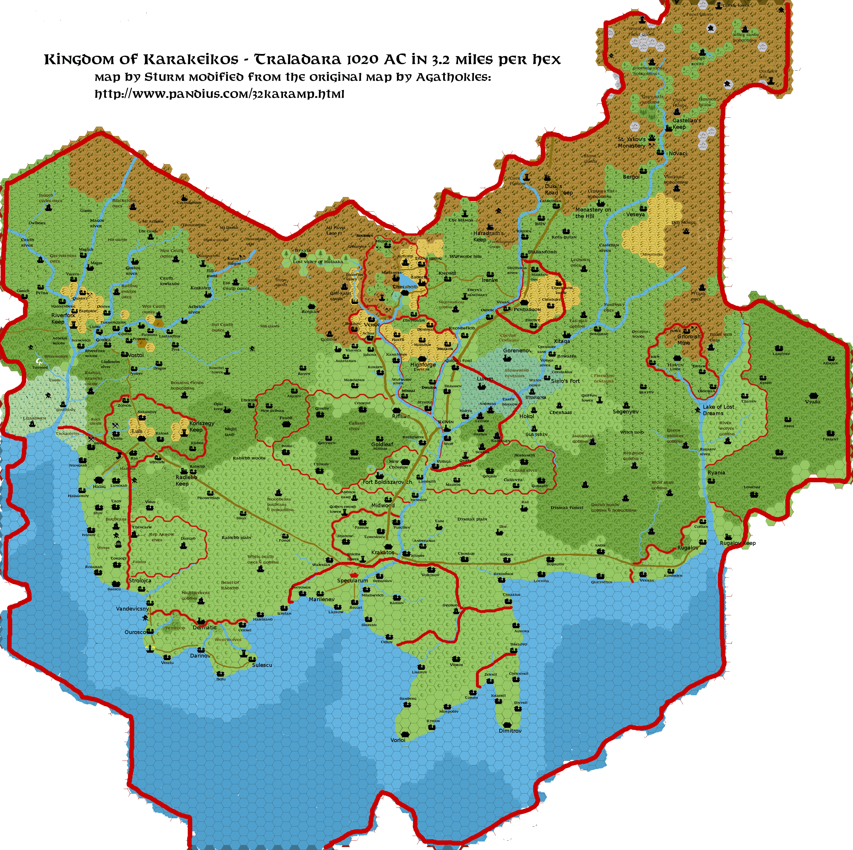
When the mixed Traladaran/Tal population of this region rebelled against the Traladaran king ruling in Marilenev in 450 AC, troops were sent to sack these communities, which were later abandoned after being targeted by humanoid raids.
This part of the Dymrak Loelands is now supposedly infested by goblins, werecreatures and dragons, and is therefore feared and unsettled by humans and elves. The truth is the Church of Nyx has several settlements here in various ruins, and has forged alliances with local dragons, werecreatures and humanoids, for unknown purposes.
Ratae [D7]
Source: created by author based on “Dawn of the Emperors” boxed set
Small
Thyatian village of about 65 Farming inhabitants, (75% Thyatian, 20%
Vyalia Elven, 5% other) Good contact with Calleva, Moderate contact
with Vyalia Elves, Machetos. On Machetos Road west; Monument,
Calleva, Veralium, Karameikos, Machetos Road east; Glevum to
Machetos. Ratae has no Inn, but a copper tavern for food or drinks;
Carborundurum ebique reptans
(Rats crawling everywhere), which
is famous for rat stew (6 sp), salted rat tails (1sp/10), and fried
rat (3sp) on the go. Wererats will find themselves comfortable as
well as not comfortable here, as all kinds of rats are consumed here
and at the same time walking around. There are several Thyatian
granaries here responsible for the infamous amount of rats. Due to
abundant use of wolfsbane Lycanthropes will be more uncomfortable
near the granaries (this due Wererat infestation last year, which
have been killed and served). Keep in mind wererats are mostly normal
rats contracted any Lycanthropy and turned to a humanoid form. These
Lesser wererats are different from the Greater wererats which were
humans infected by wererats. For more information on this read PC4
Nighthowlers.
Laws; low with attempts to
become more strict.
Rodemus Castle (Aka Haunted Keep) [D1]
Source: D&D Basic Rulebook (1981)
Note:
“The Haunted Keep”, inhabited
by the Rodemus wererats, was originally described by Tom Moldvay in
his 1981 D&D Basic set rulebook. However, there was no map
placement as these rules did not cater for wilderness/overland
adventures, and the Known World /Mystara concept had not been
created. In the subsequent D&D Expert rulebook later that year,
there is the first map of the Grand Duchy of Karameikos, and a
location for “The Haunted Keep” is
shown. Accompanying text notes that “Luln
is a base town for exploring the Haunted Keep, also called Koriszegy
Keep...”. In the 1983 edition of the
Basic rules by Frank Mentzer, there is no description of a Haunted
Keep; and in his Expert rules “The
Haunted Keep” has the same map
placement as in the 1981 edition, near Luln and associated text reads
“Luln is near to the Haunted Keep of the
Koriszegy family...”. Finally in Aaron
Allston’s GAZ1: “The Grand Duchy
of Karameikos”, the map location is
labelled “Koriszegy Keep”, while
text describing the forts in the wilderness refers to
“...the ominous presence of the haunted Koriszegy Keep...”
(and the history of Koriszegy later expanded
in “Karameikos: Kingdom of Adventure”).
In 2008 members of
the Dragonsfoot forums collaborated
on the production of as complete adventure module based on the
Moldvay outline from 1981,
https://www.dragonsfoot.org/php4/archive.php?sectioninit=CD&fileid=234
Francesco Defferrari (Sturm) has suggested
placing the ruins of Rodemus Castle in the Dymrak region.
This ruined castle, of the Rodemus family is now infected with Wererat lycanthropy and in league with goblins. PCs adventuring here are assumed to live nearby, and some townsfolk have been kidnapped by goblins that seem to be using the keep as a lair. The Dragonfoot adventure module describes the location in detail.
Rugalov River (formerly known as Haven River) [B5, C5, D5]
Source: module B10.
This long river originates from the Lake of Lost Dreams in the Havenregion. It has rocky forested banks with a 15ꞌ to 45ꞌ deep rocky/pebble riverbed. The river’s width varies from 50 to 250 yards , wider at its southern end and smaller at rapids/waterfalls. This river has a strong current of 45ꞌ to 80ꞌ per round rising to a rate of 80ꞌ to 180ꞌ close to rapids. The irregular currents, rapids and waterfalls at the Haven Cliffs, make it impossible to use vessels beyond Ryania. Even using a canoe requires a skill check to maintain control every Turn.
On 22 Ambyrmont 968 AC the Haven River was officially renamed the Rugalov River to honor the work of Lord Rugalov in saving as many people as possible from the flood disaster of that year (see timeline of the region in previous article inThreshold Magazine #23 http://www.pandius.com/Threshold_23.pdf).
Small and regular sized fish live in the river (65% small, 35% regular24). There is a 5% chance with fishing every 8 hours to catch an old object from the Taymoran, Traldar, or Hutaakan Era or even something that belonged to Goblins or Gnolls who lived in this region. These items are valued at 1d10 gp to historians (only to be found in Threshold, Kelven, Specularum, and Luln or in foreign lands), and have no magic value.
Rugalov and Rugalov Keep [D5, Keep D6]
Source: GAZ1, Sturm’s History material, KkoA, PWA1 to 3 and JA
In 968 AC Rugalov Keep stood on the east side of the mouth of the Haven River, opposite the town of Erroton on the west side. This Traladaran fortification was the seat of Lord Ionut Lutescu, Baron of Rugalov. On 15 Vatermont 968 AC, however, the Redtop Volcano on Fire Island in the Sea of Dread erupted, resulting in a huge storm and tidal wave. This tidal wave devastated the mouth of the Haven River, with the greatest impact on the western side where Erroton suffered greatly, its buildings being destroyed and many of its residents being killed. Lord Lutescu was instrumental in mobilising forces to rescue and help survivors. The town was now a muddy morass of destruction left by the tidal wave and was abandoned, the survivors settling in Coltian, Veralium, Kondrien, or setting up new farms nearby.
One of Stefan Karameikos’ earliest decrees as the new ruler of the Grand Duchy in Kaldmont 970 AC was to endorse the building of a new settlement on the western side of the river mouth. To further ingratiate his new leadership with the locals, Stefan fostered the renaming of the river as the Rugalov and the new settlement’s name as Rigalov village in honour of the the work Lord Lutescu had performed in rescuing the survivors of the flood. The Traladaran Barony of Rugalov became part of the new nation.
The new settlement stands on the Eastron Road, west of the Fain Flinn’s Bridge that now crosses the river and connects to the to the Machetos Road. The nearby Cloister of Zirchev is regularly visited and used to trade seeds and fertilizer. The town has a small harbour just over a mile to the south-east, sparsely used by merchants, but busy with local fishermen. There is a 220 hull point capacity anchoring point in the mouth of the Rugalov River for medium and smaller vessels.
Today Rugalov is a fishing and trading village of 650 inhabitants. 50% of the population is of pure Traladaran descent, 20% is pure Thyatian, 10% is mixed descent while the remainder 15% are Vyalia Elves and 5% of other origins. The village is home to about 20 dwarves and gnomes , and around 100 Vyalia elves of which Thellmusar (male E9, 320 years, LN) is the most important as he is the local voice of the Vyalia here (a sort of mayor).
The current Baron Rugalov is Lord Vlad Lutescu who succeeded to the position after his father’s passing in 998 AC. He resides in the rectory next to the small Church of Traladara which overlooks the village and its surroundings. The church graveyard is unexpectedly large, but this is due to the number of locals who died during the great tidal wave disaster. As well as the new family houses, the rebuilt settlement has a Town Hall, seven warehouses and 38 various shops, together with a large Market for all traders to meet two days a week. With the market allowing merchants from Karameikos and Thyatis to meet and trade, a desire for a bridge across the river became stronger due to the Thyatian influence on commerce. Most of Rigalov’s revenue comes from trae and from providing services to the garrison stationed at Rugalov Keep, with a smaller amount from fishing, local farming, and logging. There is one silver grade (Zirchev’s Bread) and two copper grade (Twisted Eel, Slipping Reality) Taverns; and two copper grade Inn/taverns: In memory of 968 and Maestro Burnovich (though originally related to the family, but no longer since the great war casualties).
No additional laws to the Duke’s Law are enforced. Control fluctuates from low to strict (mostly following the rules for a period and then relaxing again). Recently punishments are higher, especially to recurring local Thyatian Vandals. Rugalov Keep
The duty of the Rugalov Keep is to keep a close eye on Thyatian activities and, in case of hostilities between Thyatis and Karameikos, to hold the road and bridge against invading troops.
The Keep is manned by the “Sword of Halav” Battalion of the 4th Dicision of the Karameikan Armed Forces. The Battalion is led by a Captain (F8) with three administrative lieutenants (F6) who command 4 Companies of troops with each Company being led by an operational Lieutenant (F6). Each of these operational Lieutenants has 4 Sergeants (F4) reporting to them who are each in charge of a Squadron of 14 troops (F1). The force has 65 horses available to be used as cavalry if needed. Defenses include three ballistae and one catapult. In the event of war, a full-strength Militia Division can be raised from the surrounding villages (as done at the time of the Great War and the abelaat attacks). The 244 soldiers of the “Sword of Halav” live in Rugalov and Rugalov Keep with their families (average total family size of 4). Under normal circumstances, each month hlf of the Battalion is rostered to be stationed in the Keep for sentry duty and training.
Rugalov population numbers
The
number of people directly connected to the military presence equates
to:
244 (soldiers) x 4 (their average family size) =
976.
Additionally, a number of offspring of the Battalion over the
years are not in the army but live locally with their own families.
As a proportion of the current extended Battalion this is is
approximately 20% = 195. The average total family size of these
people is 3, giving a total additional population of585 for a total
of 1561 (976 + 585).
Roughly doubling the 1561 figure to cater
for the already existing local population means that about 3000
people live in the Barony of Rugalov - 650 in Rigalov Village, the
others in the Keep, the villages of Kondrien, Verrau, Coltian or on
nearby farms.
Ryania [C5]
Source: module DDA4.
The settlement of Ryania is by the Rugalov River in the woods of the Vyalia elves (see the Lake of Lost Dreams entry). 145 Vyalia Elves and Traldar humans live here and are engaged in orchard tending, hunting and forestry. The Mayor of Ryania is Roderick, Duke Stefan’s Lord Forester of Dymrak (see details in module DDA4: “The Dymrak Dread”). The Traladaran adventurer Alexei Schelepin, (see details in module DDA3: “The Eye of Traldar”), likely a member of the Order of Zirchev also lives here.
The village has great contact with other Vyalia settlements; and moderate contact with local humanoids. There is also good contact with Rugalov, especially with Rugalov merchants and its market for trading in wine and tools, as well as with Thyatian merchants for Elven wine trade. Moderate contact local humanoids.
Karameikan law is loosely observed with attempts to become more strict. Vyalia Law, with respect to plants, plantations, animals and magic, is more strictly followed.
This site is said the be the original location of the Secondary Effects of Magics law developed between 990 AC and 1000 AC: where a spell on itself may cause no direct harm, yet unintended damages or damaging effects might do so. Such acts of damaging are now officially covered in the Karameikan law as equal to Theft of similar valuables, caused by the caster. Alfheim, Darokin, and Thyatis have similar laws. The final draw to create this law was a forest fire here in Ryania, caused by a fireball cast at some goblins by uncareful adventurers, in 990 AC.
Scalania [D4]
Source: created by author
This is a small settlement of 138 elves and humans in the woods of the Vyalia Elven (see the Lake of Lost Dreams entry). They grow fruits and grapes for their major produce: elven wine. The population has moderate contact with Rugalov and local humanoids; good contact with other Vyalia Elven settlements; and some minor contact with Callarii elves. The village has no Inn, but does have a single tavern.
Segenyev [A4]
Source: module B10.
This is a Traladaran dun settlement, on a trail that leads south-west to Sukisyn and north to Skyrtiv. The village was rebuilt and expanded after the events of module B10: “Night’s Dark Terror”. It has no inn, but there is a Tavern: The Hardy Oak.
Serkos [B1]
Source: Sturm’s map.
This site is a fief of the Serkos, a family of Thyatian knights, followers and vassals of Lord Kelvin. There is a small castle and Traladaran settlement of about 55 farmers and hunters. The inhabitants have moderate contact with Kelvin, and Callarii Elves; and minor contact with humanoids. It lies at the end of a trail that runs south-east to the Callarii/Kelvin Road. There is no Inn, but a copper grade Tavern: Serkos’ Heart provides refreshments. Karameikan Law is followed strictly.
Sibeon [D1]
Source: Sturm’s map.
Standing near the point that Dim Creek flows beneath a bridge carrying the Eastron Road, this village was originally named Vostik, meaning “road to the east”. It is now the fief of the Sibeon, a family of Thyatian knights, and comprises of a small castle and a Traladaran settlement. There is a copper grade Inn/Tavern: Halav’s Breath (suggesting the importance of the nearby ruined shrine of Halav).
From here, the Eastron Road goes east to Soprotiv and west to Krakatos (beyond the regional map). About 7 miles west along the Eastron Road there is a trail that leads to the Cloister of Petra. Across the Eastron Road from the village, a trail leads south to Kerosinos, and there are minor trails to the south going local farms south.
Sibeon has good contact with all other road settlements and the Cloister of Petra; moderate contact with off road settlements’ and minor contact with Rodemus Castle and Dim. Karameikan law is strictly obeyed.
Sielo (often called “Sielo’s Fort”) [A2]
Source: module B10, Penhaligon Trilogy, Sturm’s Karameikos History maps
This is the site of an ancient Traladaran wooden palisade dun fort close to the Volaga River that dates from before 1500 BC. It was rebuilt and extended after the events of module B10: “Night’s Dark Terror” and the Penhaligon Trilogy. There are about 80 inhabitants engaged in farming, fishing, hunting and logging. The population has moderate contact with Kelvin and Callarii Elves; and minor contact with humanoids.
The settlement stands on a trail that runs south to Ilyakana and north to Bywater (beyond the border of the regional map). While there is no inn, there is a copper grade Tavern: The Fence, and a communal soldiers sleeping hall where guests may also reside for a few days (at 25sp/night/person).
Laws are enforced as normal with attempts to become more strict.
Skebos (aka Srebos in Traladaran) [B1]
Source: Sturm’s map
Thi is a Traladaran settlement that welcomed Lord Kelvin right from the start in 970 AC and, as a result ,the local Traladaran lord has excellent relations with the Baron. It has a population of 45 who farm, fish and hunt. They have moderate contact with Kelvin, and Callarii Elves; and minor contact with Humanoids.
From the village, trailsl go south-east to the Callarii/Kelvin Road, and north to Andreas. There is no inn, but a copper grade Tavern: Five Deer provides refreshment. Karameikan laws are observed as normal with attempts to become more strict.
Skrytiv [A4]
Source: Sturm’s map.
The current name of this village means “Hidden” and it was originally an almost abandoned Cashel (a stone ring fort as described in accessory PC1) with some remaining sidhe, until some Traladarans fleeing from the Thyatian invaders of 900 AC found safety here. Subsequently the locals developed contacts with elves, gnomes and dwarves of the Haven area and they now provide a vital link between the settlements east of Kelvin and the region of Haven. The villagers consider themselves under the protection of Haven, which indeed has often protected the locale against the harassment of goblins and other creatures.
Skrytiv is currently a settlement of 195 humans. dwarves, gnomes and sidhe who engage in forestry, farming and hunting. As this settlement has welcomed gnomes and dwarves over a long time, they have become an important part of the local culture, and all the dwarves and gnomes here speak Elvish in addition to their ntive language. The population has moderate contact with humanoids from the north and Argos the Dragon; and minor contact with Vyalia Elves. Their major contact is with other Haven settlements.
The village has no inn,but it does have a reasonably large silver grade Tavern: Isse-i Oron ruste (Where the Mountain crumbles). The tavern clientele of rugged dwarves is prone to non-lethal bar brawls, but make things good the next night. Laws are loosely followed, but there are some attempts to become more strict.
Skull, The Island [E4, Island map]
Source: created by author after blot on Sturm’s map.
This island is noticeable for the fact that it has no true shoreline - there are no beaches around its coast, the land ends and abruptly drops into the ocean. A small conglomeration of 11 buildings that are the homes of several dark-skinned humans, most of whom never leave the island other than to fish in its immediate surrounding waters,. Superstition and old tales speak of wonders of this island, and times where the island was located elsewhere.
Adventure suggestion:
Recently,
the son of a former inhabitant, who had travelled to the mainland
married a Darokinian woman,returned to the island.The son had become
an experienced mage and was intrigued by the tales and superstitions
his father recounted to him in fearful tellings. How could the island
have been located elsewhere? Why were there no shores? There was only
one logical reason that the mage could envisage: the island was a
vessel of some sort floating and anchored at present, but also
movable.
Arriving on the island, the mage erected a small two storey half-spherically shaped tower on the highest coast. Even though he could have easily subdued the locals and controlled them with his magic when they voiced concerns, he merely ignored them. He began experimenting, exploring and studying, and discovered that the material comprising the island was not stone, but was organic.
It is an individual DM’s choice as to what the truth is: is the Island a large dead creature or is it still alive and just sleeping?
In either case, the island was/is a Zaratan, a grandiose sea turtle of such immense size as to be mistaken for an island, attested to by Real World literature and folklore sources in Anglo-Saxon, Irish, Persian, and Greek literature and folklore, among other cultures. Zaratans are notable for their long-life span and impossible size. Zaratan shells are easily mistaken for small islands. The Zaratan is catalogued in Jorge Luis Borges's El Libro de Los Seres Imaginarios (The Book of Imaginary Beings), and in this author’s Mystara Monster Manual Compilation Book Animals page 395 for D&D statistics based on AD&D2 statistics25.
Smugglecoast near Skull [E4, Island map]
Source: created by author from blots on Sturm’s map, and vague descriptions in Penhaligon Trilogy.
There are many small caves along the rocky coast here. Inside the caves, solid ground is between 10 and 20 feet above sea level, which rises by 4 feet at high tide and drops by 4 feet at low tide. Smugglers# vessels go out and intercept other vessels on the Trade route, with whom they trade, or steal bringing their gains back to the caves to be hidden for a few weeks at best and them selling them on, avoiding taxes due. Smuggling is considered theft by Karameikan Law, and the fine/arrest depends on the value of the smuggled/sold goods recovered. Proof of a smuggler’s activity is difficult as the coast is long, with many hiding places. Many passing traders also earn money from these activities, and most is done in the dark or under the cloak of magic or cleverness.
Adventure
suggestions:
PCs could be used to help a
smuggler with a problem, become smugglers for specific goods, or be
involved in settling competitive smuggler rivalries, or even helping
prove the identity/arrest of smugglers. This location can also be
used (with a few alterations) for the adventure “Island
of the Dry Skins” from accessory PC3..
High/Low Tide Times
For
ease of play:
Low tide is at 0700 and
1900;
high tide is at 1300 and 0100;
each tide lasting 1
hour;
on every 2 days following, add 2 Turns (20 minutes) per day
for each tide time.
If a DM wishes to replicate real world tidal frequencies, and wish to engage in the detailed calculations, they could use information from TM1: Western Countries Trail Map to identify the lunar rise times above Karameikos and determine a more exact time for the tides by placing high tide exactly in the middle of the moons rise and fall, +6 hours low tide, +12 hours High tide, +6 hours low tide, and then adjusting each day as above26.
[Image: Map of Smugglecoast near Skull]
Soprotiv [D2]
Source: Sturm’s map.
The name of this village means “Resistance” in Traladaran and it has a history of defiance against the conquering Thyatian troops from 900 to 970 AC. The settlement was razed and burned by Thyatian soldiers of the Retebius family several times but most of the Traladaran inhabitants managed to survive and rebuild. In the decades since Duke Stefan became ruler of the nation, it has had a more stable atmosphere, but there have been occasional skirmishes and disagreements with nearby Locrida and officials from the Retebius family who rule the local dominion but have minimal control over Soiprotiv. Some Thyatian officials have accused the village of harboring evil cults, but no proof has been found and the locals dismiss the accusations as Thyatian propaganda.
The population of Soprotiv is about 115 farmers, fishermen, orchard tenders and smugglers. The inhabitants have good contact with all other road settlements; moderate contact with off road settlements’ and minor contact with Locrida, Rodemus, Retebius Castle, Callarii Elves and humanoids. Standard Karameikan law is observed but with attempts to become more strict.
The village is by the Eastron Road where a bridge crosses the Soprotiv Creek. The main highway runs west to Siberon and east to Andis. About 3 miles west if Soprotiv a trial branches north to Traladaran Shrine for Chardastes clerics and healers. From Soprotiv itself trails run south to Locrida and north to a ruined Temple of Leptar and on to Rodemus Castle. Minor trails go south to local farms. There is a There is a copper grade Inn/Tavern: Hairy Lies, that has hints to legends of the ruined Leptar temple.
Statues
Source: created by author
Far
west on Tomb Hills:
A large (28ꞌ
tall) local rock statue from the Traldar/Hutaakan Era resembling an
unidentified human male torso.
Central
Callarii:
A large (21ꞌ tall)
marble statue of three dancing elves created over a period of 1100
years (finished 967AC) by the Callarii elves as a memory of their
happiness finding this area so long ago.
On
Machetos Road close to Veralium:
A large
statue (15ꞌ tall) of Emperor Thincol of Thyatis standing
unarmoured looking to the west (Karameikos) with folded arms.
Created 977AC.
East
of Tomb Hills:
This is a giant Hutaakan
statue (120ꞌ tall) of white granite, severely damaged). Its
arms lie nearby. There are some doors in the large base, but these
have never been opened and have resisted all spells and damage
attempting to penetrate them. It is unknown what is hidden below, and
why it was built here so long ago.
The statue’s face has totally disintegrated, and lies at the base in chunks overgrown by brambles.The statue was possibly a Hutaakan cleric asan arm holds a scroll stick, although the stone scroll has been destroyed, as has the object around the statue’s neck possibly a holy symbol. The damage has probably been made by angry Traladarans who believe the statue is of an old gnoll ruler, ad have vented their anger at this symbol of a race they have a long antagonistic history with.
North
of Elbai Fields:
A medium sized (8ꞌ
tall ) granite statue of a dwarven miner holding a large crystal rod.
ON the base chiselled in Dwarven runes is the name: Gullbrig with a
date relating back to 894 AC. (This is a statue of the owner and
creator of the nearby Crystal mine).
Stormwind Centaurs [A1]
Source: Sturm’s map. created by Havard in Centaurs of Karameikos: http://pandius.com/karcent.html.
A clan of centaurs roams the hills south of Penhaligon and the Stormwind Plateau.Having suffered many losses as a result of abelaat attacks, there are now only 54 centaurs (levels 1 to 7), of which 18 are adult males of 3 to 7th level.
The Clan Leader is as always the oldest and most experienced Centaur of the clan, and that is currently Cumin (male Centaur 8, CN, Wicca1, ST 17, IN14, WI14, DX8, CO10, CH7, age 33). Several Traladaran humans who have escaped from Iron Ring slavers or from the Law, live among the centaurs and are fiercely loyal to them.
The centaurs only follow Karameikan law in a strict sense if paid to by Karameikan forces. Otherwise, they adhere to their own law, being strict on theft, and very strict on assault which is severely punished by banishment, whipping and/or branding.
Sukiskyn [B2]
Source: module B10
This is a Traladaran dun settlement on the Syereb river that flows north to the Volaga. It was originally described in adventure module B10: “Night’s Dark Terror”. (See the map by Lucky http://www.pandius.com/Sukiskyn-Map.jpg based on the module’s version, for the layout of the site. There are now about 35 inhabitants engaged in farming, hunting and logging.
After the events of module B10 adventure and the Penhaligon Trilogy (1008 AC+) Sukiskyn will undergo some rebuilding and expansion. Additional homes (size as the original map’s buildings #3, #6, or combined #13/14/17), with two shops (the size of building #4) are built in the eastern, northern and southern clearings along the roads and in between (with their own small roads) and Palisades erected around all of these. The north and south yards become a market. The pens will have relocated to the extreme north-west, north-east and south-east corners of the area within the palisade. Large tracts of trees will be removed to provide small farms on the northern and eastern side. The western side will also be cleared to a lesser extent and several more houses built along the road but without any palisade. The bridge and building #2 will have been rebuilt and expanded to accommodate the passage of wagons, and by 1009AC there will be a toll of 1 sp a person 2sp a horse and 5sp a wagon. Karameukan law is loosely followed with attempts to become more strict.
From Sukiskyn trails go west to the Callarii/Kelvin Road, north to Hokol, and north-east to Cherkass. The trail east to Segenyev is widened to provide easy passage for average wagons (3 horses abreast).
Syniel [A7]
Source: Sturm’s map
This is a typical elven homestead village in the woods of the Vyalia elves (see Lake of Lost Dreams entry). Its name means “Sunset dream”. The 350 inhabitants tend vineyards and orchards as well as engaging in hunting and forestry. They have intense contact with other Vyalia settlements, and moderate contact with Rugalov (particularly with its merchants and market for trading in wine and tools), and also with Thyatian merchants for Elven wine trade. Karameikan law is loosely observed, while Vyalia law is strictly applied (especially in respect to plants, plantations, animals, and magic).
There is no inn, but there is a silver grade Tavern: Valerias milqu-Ilsunda (Valerias kissed Ilsundal). This name is based on the rumour of both Immortals sharing an intense relationship. The tavern is known to have an underground chamber (almost a temple) of love to all. However cross-race or cross-clan love, is still not tolerated and remains frowned upon by the Vyalia; to them Valerias is an Immortal Elf and not a human as worshipped by non-elves.
Syereb River (unnamed by Thyatians) [C2, B2, B1, A1]
Source: module B10.
This is a short river originating from Syereb Lake in the southern Tomb Hills. It is 50 to 100 yards in width, and the riverbed is between 5ꞌ and15ꞌ deep. The Syereb is mostly used to let logs felled by woodsman to flow down river, into the Volaga and on to Kelven, or Specularum.
Small (65%) and regular (35%) sized fish27 live in the river. If a PC goes fishing, there is a 5% chance every 8 hours that they will catch an old object from the Taymorans, Traldars, Hutaakans or even Goblin or Gnolls who lived in this region. These items are valued at 1d10 gp to historians (only to be found in Threshold, Kelven, Specularum, and Luln or in foreign lands), and have no magic value.
The river’s normal current has a speed of 25ꞌ/round which will influence the swimming speed and direction of any character or creature in the water. However, once a day the water flow increases - up to 45ꞌ close to Lake Syereb and up to 30ꞌ where it joins the Volaga. This is at 15:00 close to Syreb Lake and an hour later for every 3 miles downstream. This increased current lasts about an hour. This will thus reach Sukiskyn 8 hours and 4 turns later at 23:40, and at Volaga River 4 hours later, causing a sudden northern push of about 45 to 90 feet to vessels at that moment. In the Volaga river this extra influx of water will pass almost unnoticed due to the increased river width. The stronger currents are due to an Elemental Water Gate opening in the Syereb Lake (see entry for that lake in “Lakes in the area above) .
If checking for encounters along this river, there is a 1% chance to encounter a 16HD Water Elemental, 2% a 12HD Water Elemental, a 4% an 8HD Water Elemental28, and an 8% chance of 1d10 Water Fundamentals29 besides any onshore creature encounters.
Tarfil Barrow [B1]
Source: Dungeon Magazine #27 adventure: “Tarfill’s Tomb”
This barrow tomb is the site of the conclusion the Dungeon Magazine adventure.
Teq-Qitala [A1]
Source created by author
This is a large ruined Hutaakan Temple of Pflarr that dates back to the Nithian era (1000-500BC), and (according to adventurers) contains a Golden Font. Like Xitaca, the temple is hidden in the many crevices and valleys of the Stormwind Plateau, It is almost inaccessible due to the vast mud plain that surrounds it and the Volaga River to the east. There is some evidence that a ford and road leading to the temple did once exist, as ancient remnants have been discovered.
Thayrn [A6]
Source: Sturm’s map.
Thayrn is a typical elven homestead in the woods of the Vyalia Elves (see Lake of Lost Dreams entry). Is name means “Shieldtree” identifying it as the place that guards the Vyalia lands to the east from the attacks by goblins and dragons of the Dymrak forest to the west. The settlement is fortified by a ring of chevaux-de-frise around it to hamper humanoid attacks.
The village has a population of 105 that includes hunters and foresters and an abnormal number of warriors, wizards, priests and experienced adventurers due to its position on the border of the wilder lands. The inhabitants have intensive contact with other Vyalia Elven settlements; moderate contact with humanoids (River wolves, Kosivikh Goblins), Argos the Dragon and Olordwan; and minor contact with merchants and markets for the trade of wine and tools.
The settlement has no inn, but there is a copper grade tavern: Natha-i-Nuinëharma (Slay the River wolves). Karameikan law is loosey observed, while Vyalia law (especially in respect to plants, plantations, animals, magic) is strictly followed.
Thrakius (Alya) [E1]
Source: Sturm’s and my old map, Sturm’s Karameikos History maps
The present-day mixed Traladaran and Thyatian settlement of Thrakius was originally a village named Ras that dates from before 1500 BC. It has also been known as Alya, possibly a derivative of Ilya after a famous pirate and adventurer who likely had great political impact on the region.
From 1 AC the village was ruled by the Traladran noble family of Rakov. But following their participation in the Marilenev Rebellion of 971 AC, the village keep was seized by the Thyatian Thrakius clan who took care to exterminate every remaining Rakov family member. The Thrakius are a family of Thyatian extremists (see Ville Lähde’s The Specularum series adventures, see Threshold Magazine issue #21 http://www.pandius.com/thrs_mag.html#21 and "The War Conceived" http://pandius.com/warconc.html). The small estate includes a large Thyatian villa that belonged to a former Senator who renamed this settlement at the same time Marilenev was renamed into Specularum. Thrakius has good contact with all other road settlements, Kerosinos, and Sibeon; and moderate contact with off-road settlements. There is a copper grade Inn/Tavern: The Eel and Diamond here (where the locals have tales of smuggling with living eels).
The Thrakius family has a great dislike of Traladarans, which in the past often got out of control with heated and violent resentment. Many rambunctious Thyatian youth in the region are supported and encouraged by the Thrakius in acts of vandalism. These crimes have included: the destruction or desecration of Traladaran shrines and temples, the burning of farms owned by known Traladaran heroes, beatings of Traladaran locals, harassment of markets, scaring and chasing animal herds, brawling in bars, and damaging Traladaran vessels.
Karameikan law is strictly enforced, and to keep it fair and equal to all, those arrested are handed over to Anton Liakos, a loyal constable of the Korrigan clan. Anton arranges the transport by prison wagon of all arrested suspects to Specularum for their cases to be dealt with there. This policy has been ordered by the Karameikan Court in 1005 AC following many serious complaints. Once in the city, it can be up to three weeks before the case is heard by a court.
The Thrakius dislike the Korrigans for meddling with the way they believe the law should be enacted. A small group of Thrakius lawyers and always follow the transported prisoners to court to ensure the suspects receive the punishment the Thrakius believe they deserve. The criminal (in the eyes of Thrakius) Traladarans are likely to receive the highest punishment possible, while the few arrested Thyatians (such as the youths who engage in anti-Traladaran vandalism) are often “proven” innocent.
The Dark Knight, Thrakius Furion Gryphon, has been allied with the Thrakius family (after which he was named) since his childhood, and has regularly spent time here. It has been a place where he felt respected and had others who had a similar outlook to his own. It was from here that the Dark Knight often searched for Sascha Mischnikov (see “The Barrel” in Threshold Magazine #23) with Thrakius family members helping.
Thunder Mountains [A4, B4, B3]
Source: modules X1 and B10, 3050 BC, 2300 BC, 1700 BC maps Agathokles, Sturm, Chimpman, Penhaligon Trilogy
The Thunder Mountains30 are a heavily eroded southern spur of the Zargash Mountains31 which branch south-west from the Altan Teppes32 mountain chain. The Zargash range forms the west and north side of the Valley of Haven. Gold is still mined33 in these mountains. The Thunder Mountains stretch south from the Zargash into the Dymrak Forest and the forested hill area called the Witchlands, where much eroded material from the mountains has been deposited.
During the Taymoran Era (around 2300 BC), the area was mined by dwarves, Taymorans and Traldar to excavate useful ores and stone. Small groups of dwarves still actively mine this region (relatively easily due the large eroded sections). They look for rocks suitable for use in building stone fortifications like city walls and towers or castles.
The geological disaster of 1750BC severely damaged the Thunder Mountains. Many mines and caves collapsed, opening the range up to the effects of rapid erosion, resulting in the loss of the former mountainous aspect as strange rock formations remain as evidence of the earlier peaks .
The line of the Thunder Mountains runs roughly parallel to a similar small, further south chain from the Taymoran Era, the Tiri Mountains. That range were destroyed and engulfed in the 1750 BC disaster. The few surface remnants of the Tiri chain are now the Grape Hills west of Rugalov, and (off the coast) Pyrehouse Rock and rocky islands by Smugglecoast.
Tolatiqek [A4]
Source created by author
A large ruined Hutaakan Temple of Ordana dating back to the Nithian era. According to stories related by some adventurers, it contains a rarely used Mithril Font.
Tomb Hills [C1, C2, C3, D1, D2, D3]
Source: created by author
Author’s note: Due to inconsistencies in canon sources regarding the direction of flow of the Syereb River, I had to introduce this range of hills to provide sufficient changes in elevation to allow the water flow to behave consistently. I have utilised some fanon sources where some hills seemed to be in existence. Based on Karameikan history and their tradition (from the pre-1750 BC Taymoran Empire) of burying their dead in tombs, I have incorporated any tombs in these hills, hence their name.
Tombs present in this location are very large, and may have several levels reflecting the map image of a branched tree, with a single entrance giving access to all the burial sites within. The bodies are interred in open and closed-off side niches that are 6ꞌ long, 2ꞌ high and wide, all along the corridors. Each tomb thus houses many corpses, and some have never been consecrated by the Ceremony Burial ritual and as a result undead have been spawned.
As the tombs are open (or easily opened due to the old worn-out doors) many other creatures have taken residence in them (spiders, slimes, oozes, jellies, stirges, rats, bats, giant rats, wererats, giant bats, wandering ghouls); sometimes temporarily wandering humanoids (at least one kobold tribe is known to reside in one of the tombs); and even nosferati from the Church of Nyx. The ease of access into the tombs means they are prone to (mostly Thyatian) plunderers.
Some of these tombs are still in use, although the Church of Karameikos and Thyatian influence over the decades has moved to the use of graveyards close to the Karameikan settlements, and even the Church of Traladara has accepted this newer burial method as also being good for the soul.
Turn Island [D5, Island map]
Source: created by author from a blot on Sturm’s map
Adventure suggestion: PCs are hired to transport the animals on the island to the shore and bring them to the market to be sold. (See the Demna Island for more on this suggestion).
[Image: Map of Turn & Demna]
Veralium [D6]
Source: created by author based on Thyatian Gazetteer, and on Sturm’s Karameikos History maps
This was originally (dating from before 1500 BC) a small Traladaran village named Vetu, after a local family. With the construction of the nearby Blackpoint Keep in 310 AC, the village became a town, and renamed simply as ”The Keep” as no clan occupied it. With the Thyatian occupation of Traladara in 900 AC, the town was renamed Verallium, and is now occupied by about 120 farming inhabitants, (65% Thyatian, 20% Vyalia Elven, 10% Traladaran, 5% other) .
Veralium has good contact with Rugalov; and moderate contact with Vyalia Elves. It stands just off the Machetos Road which runs westwards past a statue of Thincol of Thyatis, and a Temple of Ixion, the Rugalov Bridge with its statue of Fain Flinn (Seen by the Thyatians as some seemingly important hero). To the east, the Machetos Road runs by Camelodunum, Calleva, Ratae, and Glevum to Machetos. A minor road runs south from Veralium to Blackpoint Keep.
Located on the shore of Lake Veralium is a copper grade inn: Elven iugis aquae (Elven water in the hills) which sells bottles of crystal clear mineral water from the lake, as well as gin brewed from local juniper on the hills. Regional laws are followed with attempts to enforce them more strictly.
Verrau [E4]
Source: Sturm’s map
This is a Traladaran village whose name means “green river”. Verran has a history of friendship with Vyalia elves, who occasionally visit it to trade. It has a population of about 110 farmers, fishermen and smugglers. Verrau has good contact with “The Barrel”, Kondrien, Rugalov and Andis; and minor contact with off road settlements, sea folk, merchant vessels, Callarii Elves and humanoids.
A trail runs north from the village to join the Eastron Road. To its south is the harbor providing a safe anchoring point for small vessels of up to 50 Hp in total, and access to the sea lanes. There are minor trails going east and west to local farms. Verrau has a copper grade Inn/Tavern: The not so secret harbor. Karameikan law is loosely followed with attempts to become more strict.
Volaga River (named Highreach River by Thyatians) [A1, A2, B1]
Source: modules B10 and X1, GAZ1 1, Dungeon Magazine #59
The Volaga is one of the major rivers of Karameikos and has its source in the Eastern Mountain spur and the Castellan River subsequently merges with it. It is between 150 to 350 yards in width, and has a depth ranging from 5ꞌ to 25ꞌ. Fish of all sizes live in the Volaga (50% small, 30% regular, 18% large, 2% giant34). Beyond Sielo’s Fort, the Volaga is not suitable for vessels other than canoes or flat bottomed boats due to the many fords and rocks upstream. The river current runs at 25ꞌ/round and will influence the speed and direction of swimmers and vessels. The river is mainly used to let cut logs flow down river to Kelven, or Specularum.
In
any 8 hour period of fishing, there is a 0-5% chance of catching an
old object from the Taymoran, Traldar, Hutaakan eras or even from the
goblin or gnolls, who lived in this region. These items are valued at
1d10 gp to historians (only located in Threshold, Kelven, Specularum,
and Luln or in foreign lands), and have no magic value. In the same
fishing period there is a 6-10% of catching junk from local humanoids
or settlements upstream. These objects are valued at 1d6-2 cp (0 or
lower =0).
If a DM intends to use the Dungeon
Magazine #59 adventure:
“Voyage of the Crimpshire”. the
location where the Crimpshire sinks is marked on the regional map.
The area is regularly visited by Water Ogres (see above). As
described in that adventure the surviving characters have to walk
through the moor back to Kelvin, as they are unaware where exactly
they are.
As described in the entry for the Syreb River, a daily phenomenon occurs where the Syreb flows into the Volaga. For about an hour, an increase in the speed of the Syreb’s current causes vessels at that point to receive a push northwards of about 45 to 90 feet before the current returns to normal. Locals take advantage of this increased flow by sending logs down stream. Vessels are advised not to cross the Syereb mouth between 04:00 and 05:00 or risk suffering log impacts.
The DM can calculate the effects of such an impact where: each of the 1d8 logs make a hitroll to the vessel with a THAC0 of 8, each causing 1d8 hull points damage below the waterline, thus -1 hullpoint per log each turn thereafter due water intake. Log impact danger at other times on the river can be prevented by using lookouts with pikes pushing the logs aside. An average of 1d8 logs will pass each hour. Any lookouts must only hit AC12 with a pike (or polearm) and succeed a strength check to push a log aside in time to prevent damage. (the Crimpshire from the Dungeon Magazine adventure neglected to use lookouts and this was the reason it sank--or will sink when the DM uses this adventure).
Witchlands [A4, B3, B4, B5, C4, C5]
Source: Sturm’s map, Havard’s work; http://pandius.com/witchdym.html, Fan text information, Russian legends.
The Witchlands are a section of the Dymrak Forest that lie north and west of the Petrified Forest, east of Segenyev, west of the Rugalov River, and south of the Haven Cliffs, encompassing the southern tip of the Thunder Mountains and the hills and woods there. Up to 50 witches live here in small individual homes spread out over the area. They are attracted here by the many standing stones and magical locations, but mainly by the many functionable plants growing in the region that can be used for brews, potions and such. They also enjoy the solitude and absence of Thyatian attacks on them, which means they do not need to masquerade as mages.
At least 7 witches live in Segenyev and help the populace. A few witches are indoctrinated by demonic voices and slowly turn evil (potentially turning into hags over time), but most are reasonably friendly and abide by the Church of Traladara.
In “The Witches of Dymrak”, Håvard describes nine hags of which Grizelda is the best known. This describes Grizelda as battling with herself against the evil forces trying to turn her into a real hag, and other moments trying to do good with her powers.
Grizzelda, Esmeralda and Gelphora are mentioned by Håvard and Agathokles as three important witches or hags of the Dymrak forest. Elsewhere in Karameikos, three witches (Karelena, Sorelena and Trilena) are mentioned in module B7: “Rahasia”. Two strange sisters, Rosabella and Rosalinda, appear in module B5: “Horror on the Hill”; they are supposedly a priest and a wizard living alone in the wilderness, but could in fact be witches. A crone of chaos (a Mystaran type of hag) appears in B8: “Journey to the Rock”, while a hag is a prominent NPC near Threshold in “The Sound of Madness” - Adventure Two in the “Karameikos: Kingdom of Adventure” boxed set.
Xit-Laqita [C2]
Source: created by author
A totally overgrown and as of yet undiscovered ruined Hutaakan village that was once home to about 200 farmers and fishermen. It can be assumed that there was once a trail leading from here to Leqtorlei. There is no knowledge of undead wandering out of the site, but these might be enclosed within. Various lower forms of life, like green slime, ochre jellies, and grey oozes, are regularly present in the region.
Yona and Arthur’s Grave: the Burial Islands [E1, Island map]
Source: created by author from a blot on Sturm’s map.
See the Tomb Hills entry for a description and conditions of these burial places from the ancient Traladaran tradition. These islands incorporate many tombs that honour this rite. As in the Tomb Hills, some of the many corpses have never been consecrated by the Ceremony Burial ritual, resulting in the creation of undead. Here, the undead are unable to leave the islands and become a menace.
Since the Thyatian invasion the use of these island tombs has increased, but almost stopped in 975 AC under Duke Stefan’s rule. Some of these tombs are still in use in 1010 AC, although the Church of Karameikos with Thyatian influence over the decades has encouraged the use of graveyards close to the Karameikan settlements, and even the Church of Traladara accepted this burial method as being good for the soul. Some stubborn Traladarans still prefer tombs.
Arthur’s Grave holds an underwater cave where Hamish McGregor (see accessory PC3) created his underwater vessel (PC3 adventure: “Voyage to the Bottom of the Sea”). His prime vessel was used in that adventure, but an unfinished copy still resides here in a dry version of the secret laboratory described in PC3. It only requires expert manual labour to make all the hatches closable with water-tight lids. Such an enterprise should only be undertaken in secrecy, as neither Karameikos, Thyatis or Minrothad would be amenable to such potentially dangerous undertakings.
It is the DM’s decision whether to allow PCs to engage with the secret vessel, finishing the hatches, obtaining the necessary fuel, and stocking it with plenty of potions/scrolls of water breathing to launch the ship. Further thought must be given to where the PCs might continue their (political or otherwise) adventures using this submersible, perhaps becoming a secret unit of the Karameikan armed forces.
[Image: Map of Yona & Arthur’s Grave]
Zackinthos [D6, Island map]
Source: created by author from a blot on Sturm’s map
Zackinthos is an intriguing location, less than a mile south of the mainland. Outwardly it appears as a very luxurious and opulent setting offering rest and relaxation to all the famous and important Thyatians who visit it on a more or less regular basis. “It is very cosmopolitan - you never know who you might meet here!” But beneath the surface there are more puzzling and darker things going on.
Visitors to the small village of Zackinthos on the main island can only arrive through the harbour below the monument to the ruler, Senator Plutarchus, that stands on the island’s southern coast. In the village are comfortable and plush accommodations for the visiting guests. Around the island are a large shrine of the Immortal Nyx, a temple of Ixion, a Shrine of Vanya and one of Valerias. On the east side of this island is a large sandy cove where guests can relax and indulge their pleasures. Two strong keeps containing ballistae, catapults and oozebombs stand guard at each end of the cove keeping away all unwanted guests. The Thyatian Laws on the island are seemingly strict, yet are in fact low with some attempts to become more strict (if required).
The westen part of the island is connected to the main one by an artificial rocky crossing that is 100 yards long and 20 yards wide. The castle of Zackinthos stands here at the end of the rock ledge. Its ruined predecessor on the south-west corner of this smaller island that was burned to the ground three years ago. The castle is the home of the settlement’s ruler, Senator Monetus Plutarchos (Cl16 Thanatos, 36hp, CE) and his wife Corrupta Incidius (Mu15, 31hp, CE), together with her bodyguard General Crepitus Proelium (F17, 67hp, LE). A large regular and rectangular green area is noticeable in the centre of the island, which might suggest the artificial nature of the isle and hint at the many chambers underneath.
About 200 yards west of the second island is a small rock that, unknown to the residents of Zackinthos, is the only place where a small vessel could carefully hide, allowing its passengers to swim and climb onto the smaller island unseen, to undertake whatever tasks they have been charged with. This is a serious weak spot in the defence and control of the island, and this depends on the actions of the PC’s to stay like this. A DM must try to keep this way of secret access or departure, or needs to find new ones.
The lavishness and comfort of the Zackinthos retreat have inspired a fiction that even the Immortals themselves (incognito of course) visit the resort to listen to what is going on in the Mortal World and perhaps engineer some outcomes. Immortals do not need to make such visits, they can monitor happenings on Mystara directly. In the meantime the visiting Senators and other luminaries play their political games of lies, deceit, intrigue, conspiracy, theft, and even murder, just to get what they desire. It is said the island has so many secrets playing on it, that if written down could make another equal island.
Adventure
suggestions: Zackinthos is a very interesting
location for “James Bond”,
“The Prisomer”
or “XXX”-like
espionage type of adventure (with magic replacing technology). Who is
really in control of the island? What secrets lie beneath the
surface? Do the same people always come here? Is it the same person
that leaves? Those overseeing the island are currently unaware of its
weak spot where uninvited visitors could access the village and its
environs via the small rock off the smaller island. A DM could
conduct some intriguing operations with PCs either being “invited”
to spend some time on the island, or perhaps being paid to infiltrate
the setting and discover its secrets. Keep in mind it is secrecy,
lies, theft, deceit, intrige, and above all cleverness to be used on
this island.
Martha Andrejev from “The
Barrel” article in Threshold
Magazine #23
http://www.pandius.com/thrs_mag.html#23
) could be used as the main link and advisor to any PCs through her
knowledge and background in illegal activities in Karameikos and
elsewhere together with the contacts she has made. A DM could have
the PCs secretly working for the Karameikan State or for a cabal of
influential Traladarans. Whatever the course of events, things will
never be quite what they seem...
Henges, Dolmen, Menhirs
Henges, dolmen and menhirs are indicated by the same hex symbol on the Dymrak regional map. (In some cases these stones have been erected on top of cave systems and can be recognized as such on the map where the cave symbol and henge symbol are merged.) However, there are differences between these ancient constructs as described below. Rather than affecting magic directly, these monuments have a positive (+1 to all needed rolls) influence on the memorization, meditation and study of magic, nature, seasons, weather, and such subjects.
The local henges and dolmens were created by predecessors of the ancient Traldar to bury their dead (or bury their burned remains in urns). The builders were probably guided by the fairy and sidhe, who along with the elves, who later made use of pf the beneficial magical or semi-magical effects of the stone erections.
Henges
Karameikan henges are between 4000 and 45,000 years old. They are clearly magical and used to call upon the power of the planet and the celestial bodies to provide direct benefit to the people, without affecting the environment. These constructs may be portals, magical amplifiers, magical alternators or have other profound effects. There are only four active henges shown on the Dymrak regional map, and are described below.
The two Wood Henges of the Island of the Lake of Lost Dreams (small map Lake)
Source; B10
These two henges (one is difficult to locate, as it is underwater) are actually portals to the Spirit Realm and the connecting Fairy Realm, and are made from living tree logs.35 As such they are internally guarded by Spirits (see GAZ12: “The Golden Khan of Ethengar”), who are unable to leave their realm here, as this passage was created for fairy and mortals only. The portal is defended from unwelcome intruders by the spirits on the inside and the fairies on the outside/. The fairies also guide welcomed visitors (fairy friends, invited guests, etc), preventing them from getting lost. Typically pixies, sprites, and nixies are found near the henges, but other fairies regularly visit the island. (see; Lake of Lost Dreams entry above)
Hardonovic’s Henge (B5)
Source; Created by Author)
The henge takes its name from a Traldar farmer named Hardonovic who lived here around 440 AC. Hardonovic had a small cottage nearby (now totally ruined and overgrown) and legends speak of the powerful henge giving his wife powers to resist the local humanoids.
This site is used by the local witches. Those who dance and enables those dancing for 1 hour or more here are able to receive the knowledge that will enable them to learn a random Witch spell (see http://pandius.com/Great_School_of_Magic_in_detail.pdf page 451-474). The random spell obtained is often of too high a level to be learnt and cast immediately, so the witch must gain the necessary levels to study the spell and then learn it before using it. While being able to learn due to the magic effect of the henge, no new spell can be gained through new or repeated dancing, until the random spell can be cast for the first time.
The Damodan Henge (See map Damodan Island)
Source; By author
This henge enables transport to (and return from) any other henge location on Mystara. However, it must be controlled from this site by a Druid or Cleric using a specific ancient ritual (described on the stones of the henge, and learned after 300 days of study) in combination with the spell Commune spell . As a result of using this spell an Immortal (usually one of the PCs’ or cleric’s faith) becomes aware of the character’s intentions and causes the henge activation to transport the PCs to a location and cause where they can help bring about a resolution (see Damodan entry).
Dolmen
Karameikan dolmen are between 4000 and 28,000 years old. These were mostly used to bury a single important person, rarely a family or couple, or groups of individuals (most of these were cremated and the ashes placed in urns). None of these have other magical powers than in the general described above. Such powers might be granted by the dead interred, or by an Immortal and a few might enable some contact and even communication. Of the 33 mapped unnamed henge symbols, about 20 are dolmen.
There are unconfirmed rumours that the bodies of Halav, Petra and Zirchev are buried under some dolmen, in separate locations.
Menhirs
Karameikan menhirs are between 4000 and 35,000 years old. These were conceived and placed by sidhe and other fairy folk to create a beneficial or alteration effect on the world. These effects included fertility of the ground, changing a river’s flow, calming geological activity, healing geological damage, and similar. Of the 33 mapped unnamed henge symbols, about 13 are Menhirs.
The menhirs indicate that the ancient races of Mystara saw their world as a living entity and had a great magical expertise. Those people used these standing stones as a form of planetary “acupuncture” that releases magical energy from beneath the ground. Such menhirs follow the guidelines from the section on Standing Stones in http://pandius.com/pages_of_virtue.pdf page 89 (ignore the mention of dual-class, this mistake is meant to depict a wizard OR a druid), and as such will have one additional power determined by the DM from the table there.
The Menhirs in the Dymrak region mostly have only one or rarely two of the above mentioned magical effects. The ancient Menhir of Albai Lake is a rare exception.
The ancient Menhir of Albai Lake (A3)
Source; By author
The sidhe and fairy are believed to have placed this menhir on an outcropping of earth on whas then Albai Lake around 100,000 BC, predating the Blackmoor Era. It is assumed by Traldaran druids and mages that this ancient artifact relates to some unknown neanderthal Immortal, attempting to save the area. The lake disappeared in the great quakes of 1750 BC, and became grassland, but the menhir still stands proud on the small edge of the former edge of the lake. A Detect Magic spell cast in the area will blind the wielder of this magic as long as the spell lasts and due to the immense magical power will subsequently render the caster colour-blind for the same length of time. The stone is about 37ꞌ tall and approximately 9ꞌ in diameter, and is decorated with a variety of sigils and symbols of bygone cultures (Hutaakan, Traldar, Taymoran, Elven, Sidhe, Gnome, Callarii elven, Hsiaou, and Neanderthal).
Some famous names are found on the menhir, including Sap-hira Tut-Muson (Taymoran heroine), Fain Flinn (from the Penhaligon Trilogy, a few decades previously), Johaunna Menhir (from more recent parts of the Penhaligon Trilogy) and more recently Adriana Karameikos (who was here during her Shearing, recuperating from goblin attacks).
The menhir creates a continuous Dispel Magic spell (equivalent to that of a caster of level 50) affecting an area of 100 yards in radius. No more than 1 person entering that area at the same time will become affected by its secondary power; the menhir identifies the character with the most positive alignment and highest experience over others to receive the spell effects.
This secondary magical power will neutralize any poison, cure any disease, halt dying, and heal half of all wounds (never more) after 8 hours of sleeping or resting for 8 hours within 10ꞌ of it. Any activities other than reading, eating, resting, sitting, meditating, drinking, sleeping, or light activities while sitting will stall any healing effects. As such, the spell functions like a staff of healing after the initial 8 hours.
In addition to the beneficial effects, a life-long quest will be placed on the affected character compelling them to write their name (or mark with their hand print if illiterate) somewhere on the menhir (even climbing onto if necessary), and protect the menhir. The character is still able to travel freely, but will feel the urge to return to this location as soon as possible when the menhir is threatened. A DM may also apply additional long-term benefits as a result of the menhir’s influence such as a raised Charisma in political cases, or a +2 bonus on saves in honourable combats, etc.
If an Evil or Chaotic Neutral character is subject to the menhir’s secondary magic, the effect will prevent healing for another 7 days, will increase the onset of any disease or poison by 50%, combined with a forget effect wiping away the memory of the menhir and its effects, and will cause intense fear if the character ever subsequently comes within 100 yard of the menhir. No additional penalties will arise. If a character has been beneficially affected by the menhir but who later shifts their alignment to Evil or Chaotic Neutral, the intense fear and forgetting effects will still be activated.
Those previously affected by the menhir in a positive fashion and still alive will become aware when another individual joins the group quested with the menhir’s protection. This group will feel content and trust to each other should they meet, while feeling discontent and distrust to those rejected.
Finnig the Witch knows of this site and previously visited it. However, she was terrified by the powerful Dispel Magic in the area and, like all other witches in the region, left without researching it further. The Dymrak witches remain curious, but do not dare to examine the location further. As a result, their main sources of information are local legends and tales told by travellers.
1See “Tavern/Inn ratings” by the author http://pandius.com/inn_rate.html for an explanation of this system
2For more on Alcohol Points see; https://breathofmystara.blogspot.com/2013/04/how-does-alcohol-affect-body-remember.html
3See: https://breathofmystara.blogspot.com/2013/04/how-does-alcohol-affect-body-remember.html for more on Mitaq. As Humans have no inherent magical abilities, that version would, if ever created, only give a double strength quadruple duration Berserk effect.
4see Rules Cyclopedia page 177 or http://pandius.com/Monster_Manual_2.pdf page 273-293. The DM should check the chosen fish species is compatible with the climate/terrain: Karameikos, Temperate, river (not deep) and size of fish is not above regular. See http://pandius.com/skills_compilation.pdf page 41 for more on fishing and equipment on http://pandius.com/What_can_be_Bought.pdf page 38.
5According to “Karameikos Kingdom of Adventure”, page 69, the use of griffons as mounts by the Order of the Griffon started “in the past few years” i.e. 1008 AC or later. From Sturm’s 1020AC map, it is assumed they have a complete functioning griffon network then. If you desire these towers can externally resemble World of Warcraft Gryphon Aviaries of which pictures are easily found on the internet.
6To have more variety on spells; As hags are created from witches you can use the information on witches in http://pandius.com/Great_School_of_Magic_in_detail.pdf pages 368, 453-474 to include more spell and background variety. If doing so remove the wokan designation in hags and crone of chaos and add a witch level of 15 to 30 instead.
7Masters of chaos were created by Bruce Heard in Dragon Magazine #180 and detailed in my compilation book on undead; http://pandius.com/Monster_Manual_4.pdf page 1387
8Author’s note: There is always something just beyond the border of the map urging me to make the map larger. I intend to detail this area will in a later map of the more northern region. Follow the topic:; http://www.thepiazza.org.uk/bb/viewtopic.php?f=3&t=15023&p=228553#p228327 at the Piazza Forums
9On Mystara witches are just another character class, and are not necessarily evil, although this is possible if they are lured by Demons (see the information on witches in http://pandius.com/Great_School_of_Magic_in_detail.pdf pages 368). Thyatians and Heldann Hattians however see Witches as evil, since they give a spirit of freedom and resistance to the people rule, against their rule, faith and culture.
10For more information about Mogreth, a nation created by John Calvin and Geoff Gander for the 2300 BC sub-setting, located in today Ylaruam. See the appropriate section in the Vaults of Pandius http://pandius.com/mogreth.html and the thread on The Piazza forum http://www.thepiazza.org.uk/bb/viewtopic.php?f=63&t=1653
11See also the work of Sturm on this here; https://digilander.libero.it/Halag/Threshold_12_KnownWorldAges.html
12A DM could rule the crystals enable (once a year on a specific date) to travel targeted characters to specific dates in the past of which maps exist (see footnote 17) and 1000 AC, 1010 AC to enable them to return someday. It might also be possible the temporal transport is in the future; 1200 AC and 1752 AC are suggested. 1752 AC is just after the Radiance exploded, and leaves the characters in a time and magic different.see; http://pandius.com/rdnc1751.html There is no control on this transportation so it is up to fate (the DM) when the crystals will lead too.
13Banshees are detailed here; http://pandius.com/Monster_Manual_4.pdf page 1318-1321
14See Rules Cyclopedia page 179
15See AC9 Creature Catalog page 24 or DMR2 creature catalog page 42, or AD&D2 Mystara Monstrous Compendium page 45
16See Rules Cyclopedia page 179
17See AC9 Creature Catalog page 24 or DMR2 creature catalog page 42, or AD&D2 Mystara Monstrous Compendium page 45
18See Rules Cyclopedia page 179
19See AC9 Creature Catalog page 24 or DMR2 creature catalog page 42, or AD&D2 Mystara Monstrous Compendium page 45
20see Rules Cyclopedia page 177 or http://pandius.com/Monster_Manual_2.pdf page 273-293. DM take care to check if climate/terrain is compatible with Karameikos Temperate river (not deep) and size is not above regular..
21 The city of Amen-Tiris from the Karameikos Kingdom of Adventure box adventure was located underneath current Kelvin, and the canals from Key-Hamintep (originally used to bring water to these dry lands for growing grain) were the reason of the marshlands to come into existence (the canals now clogged, and grain no longer grows here). See also;
http://www.thepiazza.org.uk/bb/viewtopic.php?f=3&t=21881&sid=7435ba400fcebbd6f0dce82cc0b1d88d
22A mule-driven mine elevator is actually nothing more than a 10ꞌ square platform with a metal cage around its edges that comes together at a point 10ꞌ above the platform. At this point is a metal loop through which sturdy ropes or chains go up to the mule. Each floor has a bell next to the exit gate in the cage. These bells will ring on various locations and drop some food for the mule(s), through an intricate rope system attached to the ceiling of the first level. The mules have learned to always go to the sound even if not hungry. As the chain from the cage is attached to the harness of the mules the movement of the mules pulls the cage up or down slowly at their normal encumbered movement rate of 60ꞌ/20ꞌ. As the elevator itself weighs 1000cn, there is a weight limit of 2000cn, which can be raised by 3000cn per additional mule. The tunnel width limits this to a maximum of 3 mules.
23see details in “The Barrel” in Threshold Magazine issue #23; http://pandius.com/Threshold_23.pdf)
24see Rules Cyclopedia page 177 or http://pandius.com/Monster_Manual_2.pdf page 273-293. DM take care to check chosen fish species for climate/terrain compatibility with; Karameikos, Temperate, river (not deep) and size of fish is not above regular. See http://pandius.com/skills_compilation.pdf page 41 for anything on fishing, and equipment on http://pandius.com/What_can_be_Bought.pdf page 38.
25For an additional image; https://vignette.wikia.nocookie.net/bloodrealm/images/a/a4/Island_turtle.png/revision/latest?cb=20140501003103
26For more on Tide see; https://en.wikipedia.org/wiki/Tide
27see Rules Cyclopedia page 177 or http://pandius.com/Monster_Manual_2.pdf page 273-293. DM take care to check chosen fish species for climate/terrain compatibility with; Karameikos, Temperate, river (not deep) and size of fish is not above regular.See http://pandius.com/skills_compilation.pdf page 41 for anything on fishing, and equipment on http://pandius.com/What_can_be_Bought.pdf page 38.
28See Rules Cyclopedia page 179
29See AC9 Creature Catalog page 24 or DMR2 creature catalog page 42, or AD&D2 Mystara Monstrous Compendium page 45
30Thyatian name; source; module B3 Green edition). In dwarven their name is Karr Rast-Karagg (Dead Barren Mountain).
31Zargash is the Traladaran name (source: module B10); the Dwarves knew it as Dronrast, (Thunder Mountain) probably due to the mountains’ high level of metal content which attracted lightning in thunderstorms. Much of the metal has now been mined and the lightning strikes are rare, and was the source of Traladaran naming of the southern spur.
32In 2300 BC these were named the Kuurmaresha Mountains.
33Source: area W12 on the 3-mile hex map of midule B10 ( just outside the Dymrak regional map).
34see Rules Cyclopedia page 177 or http://pandius.com/Monster_Manual_2.pdf page 273-293. DM take care to check if climate/terrain is compatible with Karameikos Temperate river (not deep) when using fish species.See http://pandius.com/skills_compilation.pdf page 41 for anything on fishing, and equipment on http://pandius.com/What_can_be_Bought.pdf page 38.