
A fan-made Atlas of North and Central Arypt
by LoZompatore- Part 1: Introduction
- Part 2: Hexed map, with scale
- Part 3: Climate, Winds and Sea Currents
- Part 4: Regions and Landmarks
- Part 5: People and Races
- Part 6: Settlements and Ruins
- Part 7: Trade Routes
- Part 8: A possible Adventure Path
- Part 9: Notes and Details about Campaign Adventures
A fan-made Atlas of Arypt Part 1: Introduction
This work originally came from suggestions and feedback by Sturm and Simone (Zendrolion) about adding a "Barbary Coast" setting (a late medieval to renaissance M-North African culture of independent city-states) placed along the Davanian coastline between the Yasuko Tribal Lands and the Vulture Peninsula.
Unfortunately the project expanded quite a bit and in its current version looks more like a sort of a sketchy atlas for North and Central Arypt and nearby regions such as the Jungle Coast.
It is currently divided into 9 parts. Perhaps I will also add a 10th section with a draft of a timeline covering some key events for the region.
Consider what follows as a draft suggesting a possible arrangement of city-states and also as a collection of canon and fanon information to better detail this part of Davania and the surrounding seas.
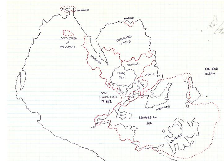
Here is the basic map I compiled for the region according to a set of references detailed below. It just shows the overall geography without tags, hexes and other details except for terrain, just to show you the end result.
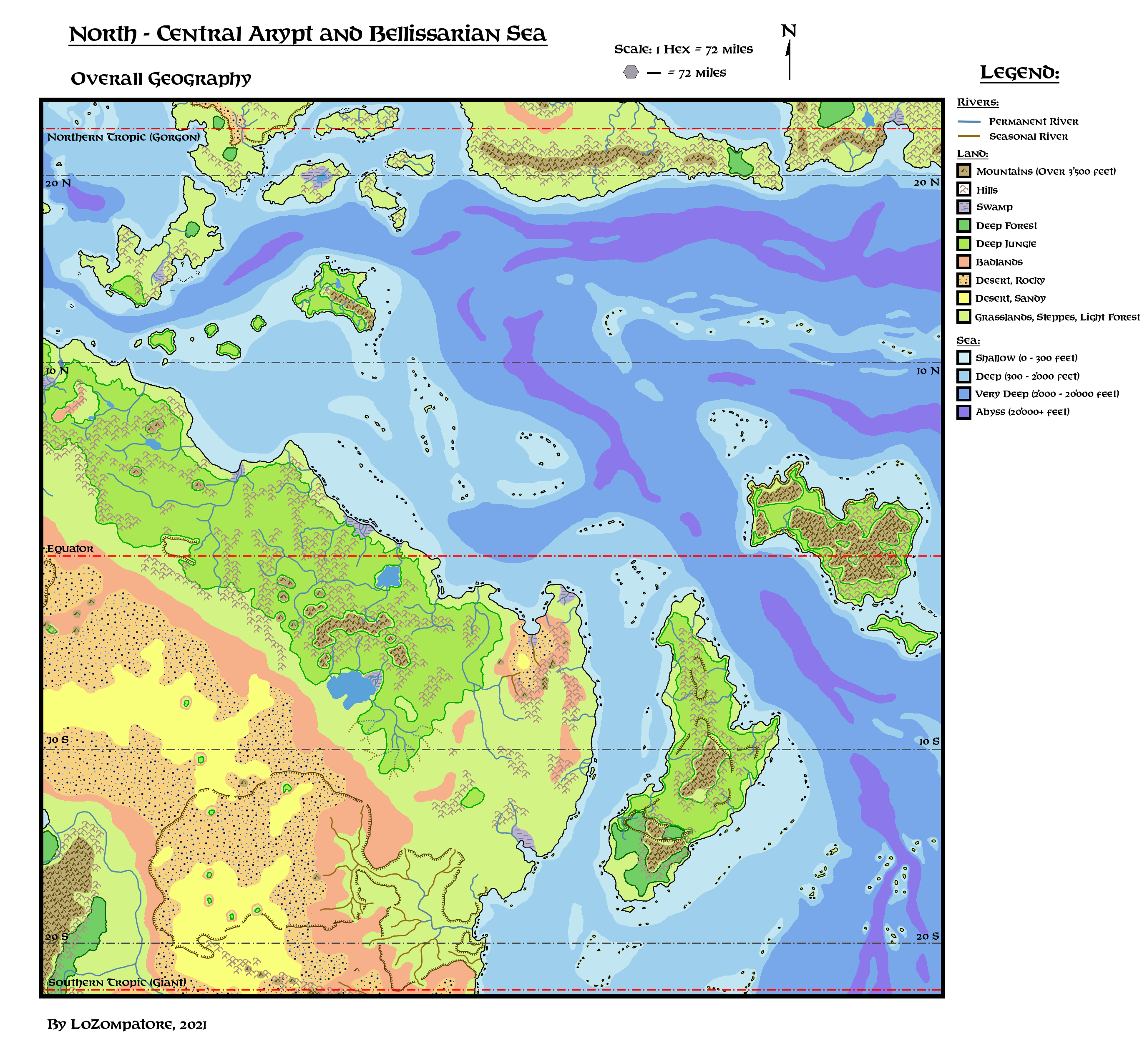
Detailed thematic maps with tags and symbols are discussed in the next Parts of this fan-made Atlas.
If you wish to download the GIMP source file to create your own thematic map or expand on this work of mine I make the file available here (zipped copy of the .xcf GIMP drawing, around 5 Mb in size).
Notice that all maps are made to fit with Mentzer's Master Set world map; the north-western tip (anything north and west of the Yasuko Tribal Lands) matches the south-eastern tip of Poor Wizard's Almanac II map, including hexes alignment.
Comments:
With respect to the other available fanon maps of the region (see the section about sources, below) I made the following modifications / additions:
The introduction of the Algarin Desert in north eastern Arypt tries to match the description found in Dungeon Magazine #50 adventure. It is mostly an arid land, not a proper desert, and it is the major deviation from the established cartography for the area (which is way less desert), albeit I tried to minimize differences. A possible way to keep both the desert and the more fertile lands is to exploit this old note on Arypt by Bruce Heard: we could say that fertile lands (those shown in Geoff's and Sturm's maps) would magically appear from another Plane/Alternate Reality only at specific times, and then disappear some weeks/months/years later, leaving the desert in their place.
The use of Jurassic Mystara model enables a detailed treatment of the oceans, in particular the placement of several island chains across the Bellissarian Sea and the Sea of Steam. I also added a mid-oceanic range in the Bellissarian Sea and several abyssal depths close to the inferred fault lines. Most islands would be volcanic or having an ancient volcanic origin.
The winding escarpment shown at the bottom of the map surrounds the dried remnant of the pre-cataclysmic Inner Sea (I figured this sea disappeared due to the same geological upheavals that led to the sinking of Lhomarr). This land is now mostly a desert plain, partially fertile only on its easternmost part thanks to a large network of wadis (seasonal rivers) created by seasonal humid winds from the sea.
I turned the southernmost inlet of Lake Arypt to an outlet, so to create a huge inland delta whose function is to water the local jungle, which should not exist according to the overall climate patterns given the dry conditions of the surroundings.
Canon Sources:
Basic official details for the region encompassing the Jungle Coast and north-central Arypt are available in the following sources:
- Dawn of the Emperors boxed set (Hinterlands and Pearl Islands)
- Poor Wizard's Almanac II (Outer World Milenians, Manacapuru / Bogdashkan / Yasuko tribal lands and reference map)
- Voyage of the Princess Ark Parts 2, 3 and 4 (Jungle Coast and Lost City, Aryptian Savannah, Cestia, Oceania and Vanya's Rest)
- PC2 module "Top Ballista" (Tabi and Katapec of the Jungle Coast and Arypt)
- Dragon Magazine #247 article "Rakasta of Mystara" (sub-species of Rakasta living in Davania).
Moreover, I guess it is safe to consider as "official" for this region also the information available in the following sources:
- Timeline of the Heldannic Knights - 2nd Millennium by Bruce Heard, available here (Vanya's Rest, Simbasta)
- I11 adventure module "Needle" (indirect placement on Mystara, fits very well on the Jungle Coast, providing information about froglins, the ruins of the Needle and mentioning the Boulder Clan of dwarves and the obelisk of Henkus the blue dragon)
- Info about climate and sea currents in the region available in this article from Bruce Heard's blog here.
Then I collected anything official and related to an "oriental adventure" setting and not explicitly placed in Ylaruam or whose official placement there is troublesome, as in the cases where the city of Serendib is mentioned.
- Dungeon Magazine #9 adventure "Djinni's Ring" (ruins of the Ivory Palace and nearby city)
- Dungeon Magazine #50 adventure "The Object of Desire" (Algarin Desert, the Sea Caves, the settlements of Sasan, Samarkand, Shebal, the Rock of the White Flame, the Fortress of Nazir-al-Azrad and potential settlements of Azrad, Arazani and Varzakh)
- AC10 Bestiary of Dragons and Giants adventure "Isle of the Storm Giant" (the settlement of Serendib, the Isle of the Storm Giant)
- AC11 Book of Wondrous Inventions - details from "Balthazar's Suite of Many Delights" (settlement of Galgaboth and nearby dungeon) and "The Sultan's Uncanny Ghost Ride" (sultan of Jalinas and the settlement he lives in, assuming it has the same name of his ruler)
To this bulk I arbitrarily added the following official sources, which refer to locations never explicitly assigned to any location in Mystara's lore. Some of the Dungeon Magazine issues listed below actually refer to generic AD&D adventures published after Mystara's conversion to AD&D (mid. 1994, corresponding to Dungeon Magazine issue #48), which I guess can be safely included in the corpus of potential sources:
- Dragon Magazine #55 adventure "The creature of Rhyl" (kingdom of Rhyl, settlement of Asereht, lair of Astylis the mad mage)
- Dungeon Magazine #34 adventure "Isle of the Abbey" (Isle of the Abbey)
- Dungeon Magazine #51 adventure "The Witch of Windcrag" (Windcrag Mountain)
- Dungeon Magazine #57 adventure "Cloaked in Fear" (settlement of Hargast)
- Dungeon Magazine #63 adventure "Beauty Corrupt" (settlements of Orchid Bay and Wyrwatch)
- Dungeon Magazine #64 adventure "Mad Chefs of Las Anchois" (settlement of Las Anchois)
- Dungeon Magazine #72 adventure "No Stone Unturned" (settlement of Jevid)
- Dungeon Magazine #78 adventure "Trial of the Frog" (the Iristone)
- Dungeon Magazine #79 adventure "Keep for Sale" (Sindar Desert, lands of Dragonclaw and Aramax, settlements of Shadel, Greatwall, Arbrenlyaan and the Keep of Khest)
- AC1 supplement "Shady Dragon Inn", backgrounds of "Eben of Whitemount" (settlement of Whitemount) and "Beryl Wayfarer" (the Far Mountains)
- AC10 Bestiary of Dragons and Giants adventures "Ravellia and the Dragon Eggs" (a black dragon nest and a nearby clan of rogue elves), "The Deluded Dragon" (settlements of Nandua, Carrack and the ruins of Denstehn Keep) and "Isle of the Storm Giant" (again Serendib and an island inhabited by a storm giant)
- AC11 Book of Wondrous Inventions - details from "Moodarvian Rings of Emotion" (settlement of Gorias)
- M5 adventure module "Talons of Night" (settlement of Garth)
I also added two Dungeon Magazine AD&D adventures published before issue #48, because both of them have references in their introductions about a possible placement in a generic Oriental of Arabic setting, respectively. I found them fitting additions to the Yasuko Tribal Lands and to the Northern Aryptian Desert. The second adventure also details an interesting plot by Yuan-ti which is quite fitting for the Aryptian area.
- Dungeon Magazine #33 adventure "Mad Gyioji" (settlement of Ise-Ko)
- Dungeon Magazine #37 adventure "Serpents of the Sands" (Avera Desert, settlements of Balthazar and Scarboro)
Some words must be spent about the overall geography and info from map below, shown in Dungeon Magazine #79 adventure "Keep for Sale".
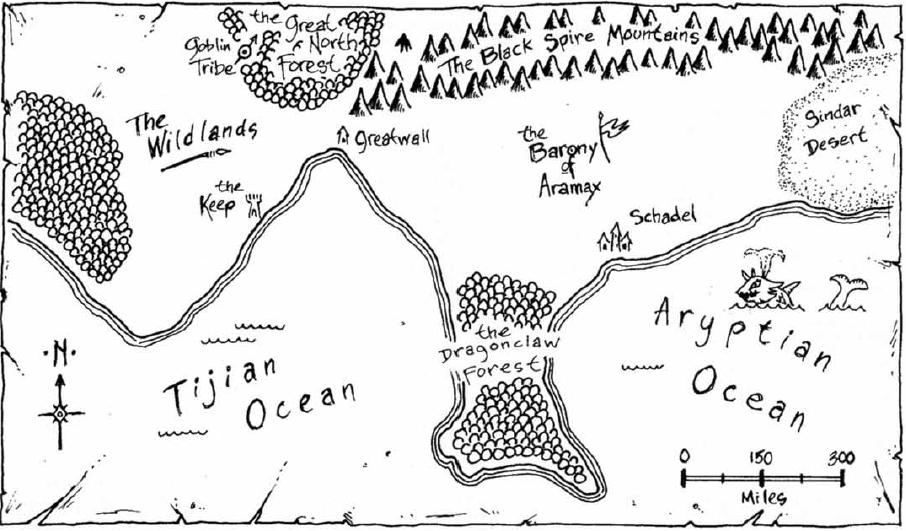
The tag about an "Aryptian Ocean" was too tempting to ignore, so I found a way to include the map in Central Davania by merging it with Geoff Gander's fanon map of the Aryptian Basin (see below). By fortuitous chance, by applying a 180� flip (as if the "North" sign is actually pointing to the South Pole of Mystara), and some more tweaking and rescaling, it is possible to match the whole coast in the map of Dungeon Magazine #79 with the southern border of Geoff's Aryptian Basin. So I included the whole adventure in the Aryptian setting, under the assumption that all locations and events refer to the ancient time of Lhomarr, when the Aryptian Basin was still an inner sea and not the current desert plain.
p>
Fanon Sources:
Then there is the whole fanon production stored at the Vaults.
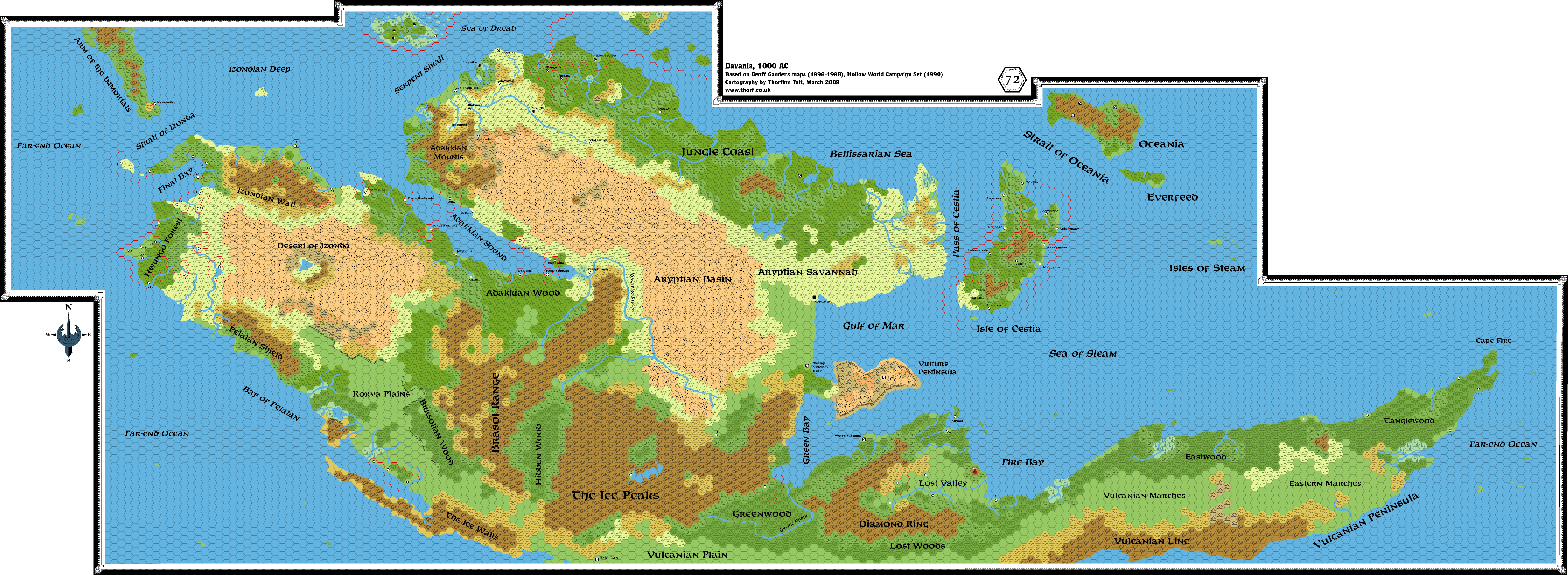
I have a preference for Mentzer's Master Set world map - instead of the Hollow World's one - so, for general arrangement of landmasses, coastlines and sea depth, I refer to Thorfinn Tait's Jurassic Mystara model (see here) and, in particular, to his map of Skothar (here), which shows the whole Bellissarian Sea and surroundings lands, including part of the Jungle Coast and the whole island of Oceania.
For the shape and extent of Oceanian mountain ranges my map is a mix between Thorf's map of Skothar and a contouring of mountains shown in VotPA maps.
About regional climate, I integrated the available canon info with Thorfinn Tait's reference climate map of Mystara available here. I made local modifications to sea currents patterns and to the boundaries of climatic zones to add details and adapt the map to other existing fanon works.
For terrain details of the Jungle Coast and Cestia I used Geoff Gander seminal layout for Davania here, including its updated version by Sturm in his great political map of this continent here, which adds quite a lot of useful and interesting details.
As both maps were made following the Hollow World reference world map I had to squeeze and stretch several areas in order to have all details fit into Mentzer's map shape. That's why terrains in my map do not strictly follow the hex grid, as I thought it was better to preserve terrain boundaries and make corresponding regions easily recognizable when comparing the maps.
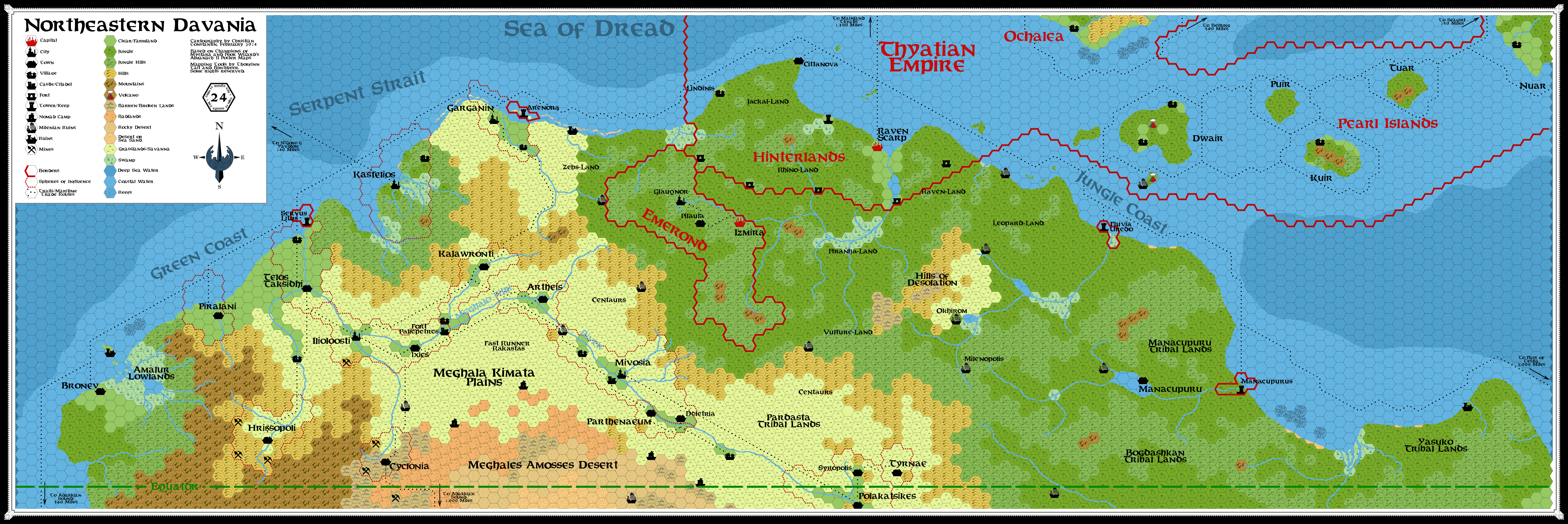
For the northernmost tip of Davania I included also Christian Constantin�s additions to the official maps (mostly isolated mountains) as shown in this work of him.
For the Jungle Coast tried to fit some elements (most notably rivers) shown in Thorf's map of Skothar mentioned above, merging them with Geoff/Sturm's map. The result is sort of a hybrid, I hope it may contribute in the detailing of the region.
A bit of the desiccated, ancient Agrisian Lake taken from this map by Havard is visible in the top westernmost part of the Aryptian Desert shown in the map.
Another notable addition I made to the Central Arypt region is the escarpment of the Aryptian Basin, whose shape is taken and adapted from the Inner Sea shown in Geoff Gander's map of the ancient Lhomarrian Empire (here). I tweaked a bit the southern coastline to get a match with the coastline shown in the map of Dungeon Magazine #79 (the similarity of both coastlines was impressive in the first place, a true example of serendipity), so I could name several regions by picking tags from it.
Finally, I included some geographical details of my own previous works (the Snarta I plateau, a few isolated mountains in the eastern Jungle Coast and several escarpments in Cestia and Oceania) which are visible, for example, in this old map of mine. Notice that the plateaus of Cestia are canon (VotPA, Part 3, Andrumir 7, 1965 entry) as are the jagged coastlines of Oceania and the river on the southern coast (VotPA, Part 2, Tsalmir 8, 1965 and Tsalmir 11, 1965 entries), albeit the shape and location of these features was made up by me.
About fanon populations and settlements I considered the following sources:
- The abovementioned political map of Davania by Sturm, integrated with his notes about people of NE Davania (here), his Secrets of Davania article (here) and his Recent history of Davania (here, including maps) which themselves link to several other sources mentioned here or stored at the Vaults (most notably the Serpentine Empire epic by James Mishler here and the Lhomarrian epic by Geoff Gander here).
- The abovementioned map of the ancient Milenian Empire by Havard; I followed his approach and used the names of a few other towns and ruins from the Hollow World map of the Milenian Empire to introduce some new ancient Milenian settlements in the Jungle Coast area.
- The abovementioned map of Northern Davania by Christian Constantin and his comments in the related article here.
- Again, by Christian Constantin, his illustrated timeline for north-central Davania here.
- Zendrolion's article about history and evolution of rakasta here, which expands on Dragon #247 article.
- Geoff Gander's description of Klath'T'zarth settlement here and here.
- Geoff Gander's basic description of the nations of Cestia (themselves expanded from VotPA lore) here.
- Geoff Gander's outline of local human kingdoms at the time of ancient Lhomarr here.
- Background for the Odak'Tar by Alex Benson here
- Alex Benson's timeline for the Pedhart Gnomes, which introduces the settlement of Ar'Tyiab (see here).
- My own compendium of fanon cultures of Central Davania here and my timeline of Snartans' migrations across the continent (here).
- Marco Dalmonte's Codex Immortalis, especially about the Immortals Bachraeus, Ninfangle, Bastet, Ninsun and the hero Gilgamesh.
- This article by David Keyser about the Coral Reef of the Strait of Oceania.
- The Ambyrmont 2 entry of the AC 1016 Mystaran Almanac as a reference for the Forlorn Lands here.
What I did NOT include insofar in the region is the fanon detailed description of the island of Oceania, available (in Italian) here, because it is mostly a reworking of "Role Aids: Dragons" supplement by Mayfair Games (see here). Nothing prevents its inclusion, though, as Oceania is a really big place, as shown in Part 2 of this Atlas.
A fan-made Atlas of Arypt Part 2: Hexed map, with scale:
Comments:
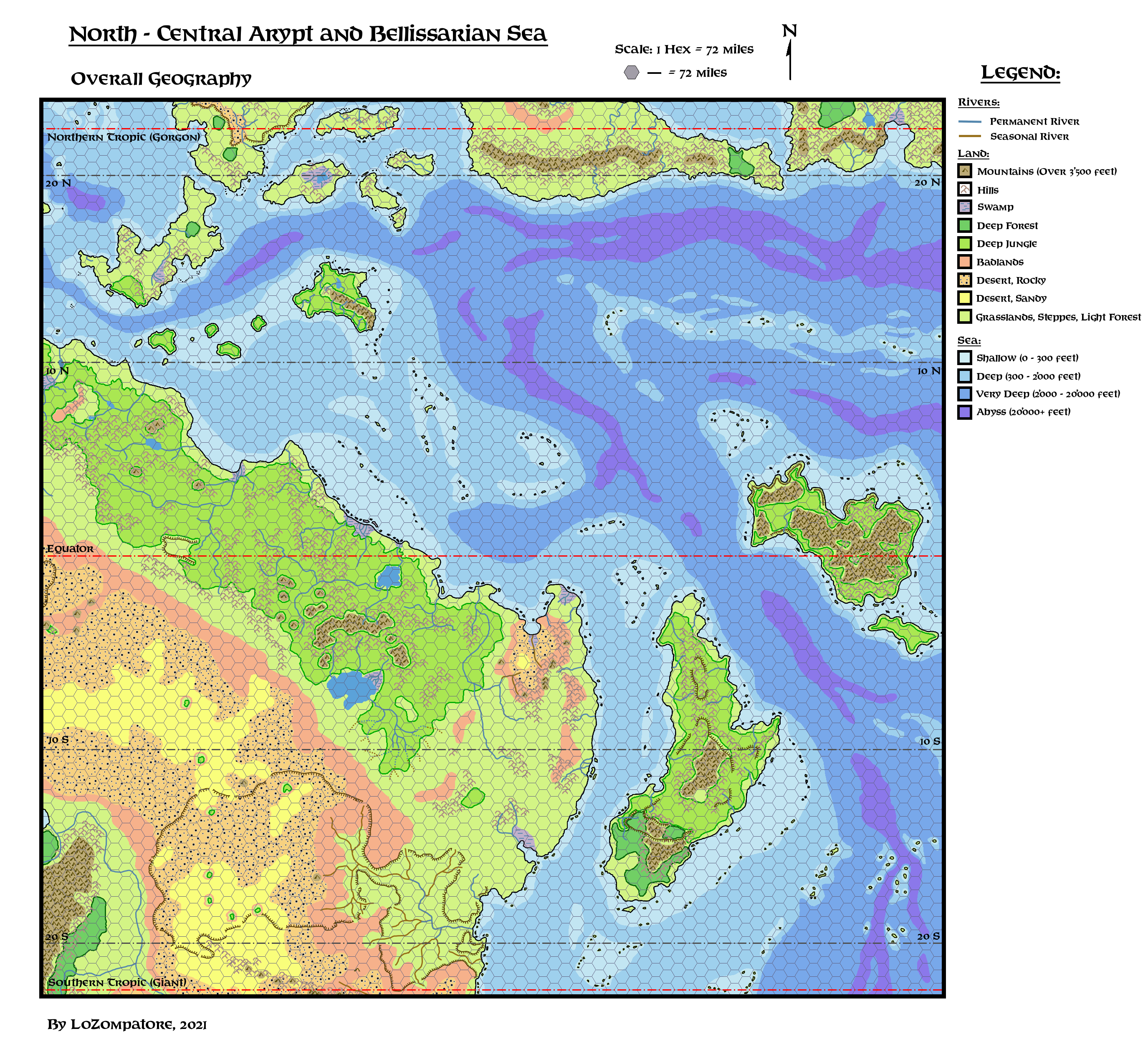
The same map seen in Part 1, only with a 72mi/hex overlay to help calculating distances and highlighting the connection with PWAII map.
I also show this map to introduce some sense of scale for the whole work.
In my opinion, the most important thing to always bear in mind is that this map covers a huge area and it may be considered a whole large setting in itself.
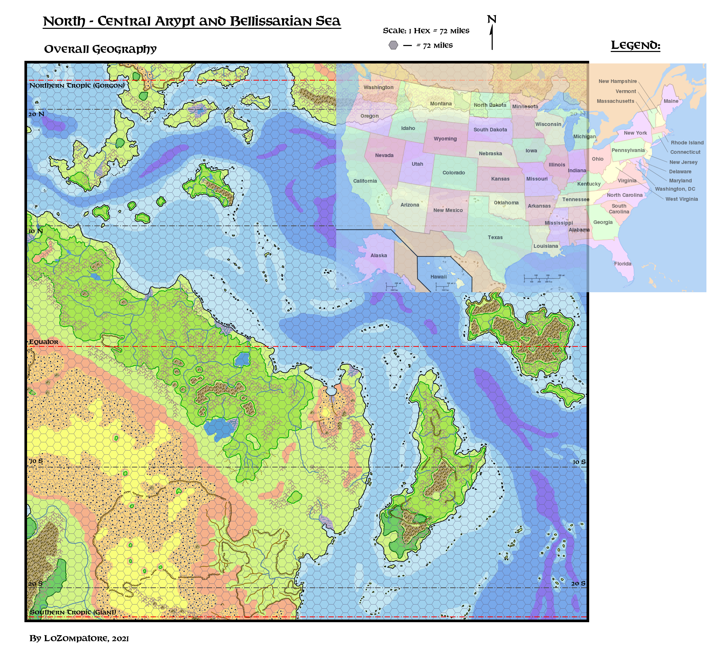
I made a couple of figures comparing this hexed map with Europe + Mediterranean Sea and with the United States, both plotted at the same scale of the hexed map:
Comparison with Europe + Mediterranean Sea:
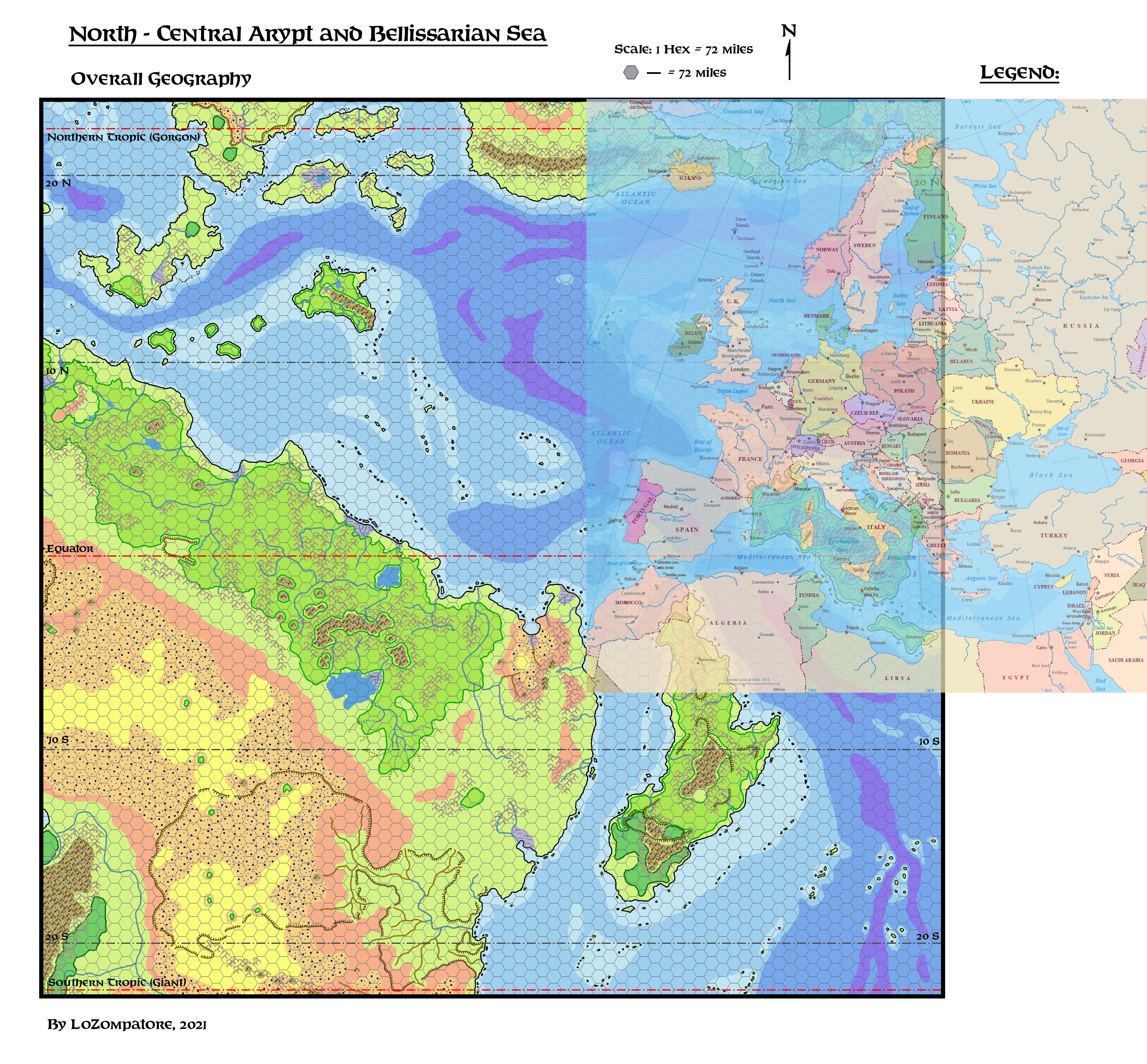
Comparison with United States:
Perhaps a few selected comparisons may help in highlighting the point about map size:
- The visible part of Davania shown in the picture encompasses some 7'600'000 square miles, which is 10% greater than real world South America and about 2/3 of Africa. It is almost double the surface of the whole Europe, so a lot of people and cultures could be added without risk of overcrowding these lands.
Notice also that, in the comparison with the Mediterranean Sea, the whole Aryptian coast - from the southern end of the jungle to the Gulf of Mar - covers approx. the same distance that is between the Atlantic coast of Morocco and the Suez Canal. For this reason I think that the whole "Berber Coast" concept for this part of setting is a fitting one. - Lake Arypt, the largest lake shown in the map, at 32'000 square miles, is about the same size of Lake Superior or of Austria. Lake Ilarnn, the second largest lake, covers a surface of approx. 13'500 square miles, which is the same land area of Lake Baikal or of the island of Taiwan. Both lakes are quite a natural barrier in themselves, and different races, people or cultures may live on opposite shores without interfering too much.
- The longest river in the Aryptian Savannah (Ninsun River, see the next parts of the atlas) is some 1300 miles long, approx. the same length of river Tigris, along which entire civilizations flourished and declined over millennia. The section of Kenaton River shown in the southwestern corner of the map is some 1850 miles long, more than the total length of river Danube and as long as the Rio Grande from Colorado to the Gulf of Mexico.
- The Aryptian Basin, the vast, semi-arid land encompassed by a plateau in the bottom of the map, covers approx. 1'130'000 square miles. Its western side (875'000 square miles) has approximately the same land area of Greenland or Saudi Arabia or, in a comparison with the United States, it covers the whole of California + Nevada + Utah + Arizona + New Mexico + Colorado + Wyoming + Idaho. The eastern part of the basin (255'000 square miles) is approx. the same size of France or Texas.
- The island of Cestia is huge: it covers some 540'000 square miles, more than 2.5 times the area of real world Madagascar, to which it is inspired. Cestia is actually 2/3 the size of Greenland or the same size of France + Spain + Italy + Portugal (considering that the island is divided among 4 countries, 3 of which shared a common origin some 2500 years ago, this last comparison speaks a lot about possible cultural differences). In US terms, Cestia covers the same land area of all U.S. States east of a line connecting Alabama with Ohio, with a longer extent in latitude.
- The island of Oceania covers some 350'000 square miles, 15% larger than real world New Guinea, which is a pretty large landmass in itself. Alternatively, you can say Oceania has the same land area of France and Germany combined or of Texas + New Mexico, or of California + Nevada + Oregon. I guess the island includes much more than night dragons and the three ruined cities described in VotPA.
- The island of Everfeed (31'000 square miles) is approx. the same size of Austria or South Carolina. Again, the island should include much more than the large lizards, birds, guano and fish described in VotPA (which, by the way, underestimates the length of the island at 200 miles while it is more than 450 miles long).
With all these comparisons in mind notice that - while the thematic maps I'll post in the next parts of this atlas will look like a crowded mass of symbols and tags - once you zoom in the scale you'll find that most of the land and sea is actually empty and still free to develop. Whole countries, people and races may fit among the ones I placed there, without too much effort or conflict.
A fan-made Atlas of Arypt Part 3: Climate, Winds and Sea Currents
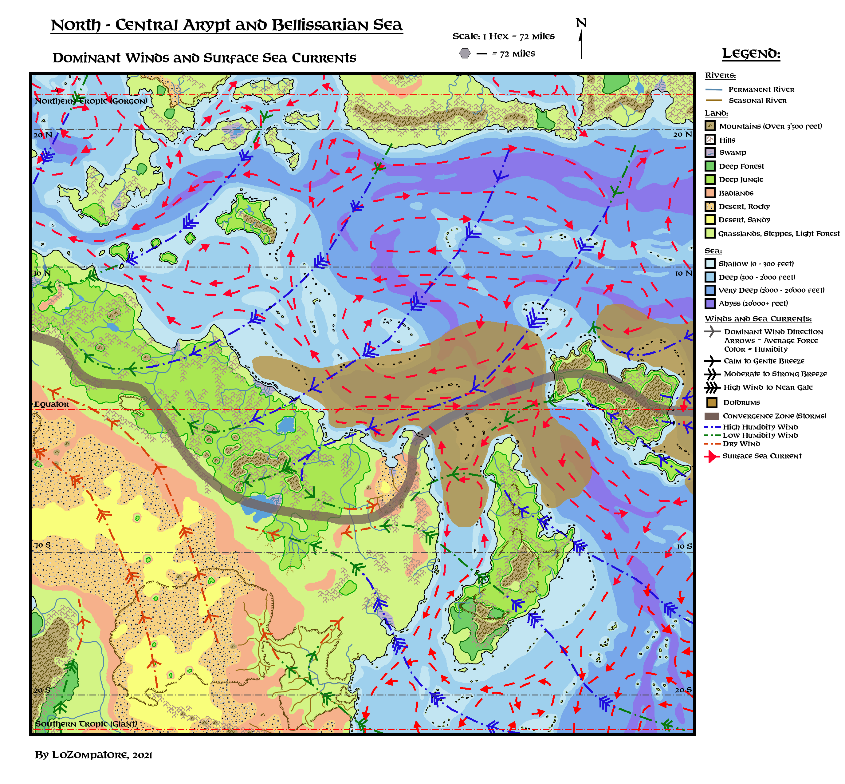
Comments:
The map above is based on the available information about climate, dominant winds and sea currents for the region (VotPA and here and here) which I expanded to add further details.
I adopted a simple climatic paradigm: warm air rises from oceans and landmasses, creating humid and dry dominant winds respectively, which then move toward the Equator following a clockwise path for the northern hemisphere and a counterclockwise path for the southern one. When humid winds meet landmasses and mountain ranges they drop most of their water with rainfalls, and become dry.
Winds have maximum speed over flat surfaces (oceans, plains) and slow down once they meet rugged terrain (hilly coastlines, forests, mountain ranges, etc.).
Moreover, given the location of the region, the intertropical convergence zone at the Equator (the region where winds from the northern and the southern hemisphere meet) must be introduced.
Ideally this zone is a belt of periodical thunderstorms and erratic, weak winds (the Doldrums), extending at least 5 degrees in latitude above and below the Equator, but this is strictly true only for the oceans. On landmasses, this convergence belt may shift in latitude moving away from the equator up to +/- 10/15 degrees.
Combining the concepts above I placed a suitable convergence zone (its center highlighted by the grey belt in figure above) so to justify the location of jungles and deserts in this part of Davania. I added Doldrums regions on the seas east and west of Oceania, and an oddly shaped wind pattern in eastern Arypt to explain the local dry wind from the NW described in VotPA (magic may also be involved in this case, especially if the concept about the extra planar, alternate, fertile Arypt is considered).
Notice also that the landmass of Cestia intercepts most of the rainfall of the humid winds from the SE so, when these winds reach the eastern Aryptian coast, they are mostly dry and little precipitations ensue.
Surface sea currents shown on map follow the same clockwise /counterclockwise pattern of dominant winds, albeit more confined by landmasses and nearby currents. I complicated things a bit across the Equator (sea branches connecting Oceania, Cestia and Arypt) emulating patterns seen in real world sea currents, which tend to disconnect northern hemisphere and southern hemisphere circulations. This leads to interesting travelling options in the Doldrums area, where sailing is not so reliable and sea currents may be exploited instead.
Finally, a few notes about temperatures.
It was already noticed by Thorf here that Mystara has a cooler climate than Earth, as results from a proper evaluation of latitudes he made in the link above.
For instance, Byzantium-inspired Thyatis city ends up at around 27� of latitude, compared to the 41� of Byzantium; Reykjavik-inspired Farend stands at 51� of latitude, compared to the 64� of Reykjavik. As a rule of thumb, add 13-14� to the Mystaran latitude of a given location (taken from Thorf's map in the link above) to get the real-world reference latitude for climate.
In my opinion, this is not an issue for the Aryptian region; on the opposite, it may be helpful to explain some things from canon such as how the Milenians adapted to local climate and managed to establish an empire across the equator of Mystara.
If temperatures at the Equator are the same as Earth at 14� of latitude (the Caribbean, southern India or Thailand) then the Milenian endeavor is not so unrealistic. The Aryptian desert and the Jungle Coast would still be uncomfortable and difficult to negotiate, but not so much as their real world counterparts at the same latitudes. This has also some in-game consequences about the possibility to wear armor and heavy equipment, rules about fatigue, and so on.
Temperatures in northern Davania (Raven Scarp at around 10� of latitude) should be similar to Earth's tropics (Hawaii, central Mexico, northern India, southern China, southern Brazil). In particular, the comparison between the Pearl Islands and Hawaii (albeit the island of Nuar is as big as Germany) is a fitting one.
Mystaran tropics, estimated at 23� of latitude, should have the same temperatures of Earth's locations at approx. 37� of latitude (central Mediterranean, central China or Japan, central US, south-central Argentina and southern Australia), definitely in the temperate range of climates.
A fan-made Atlas of Arypt Part 4: Regions and Landmarks
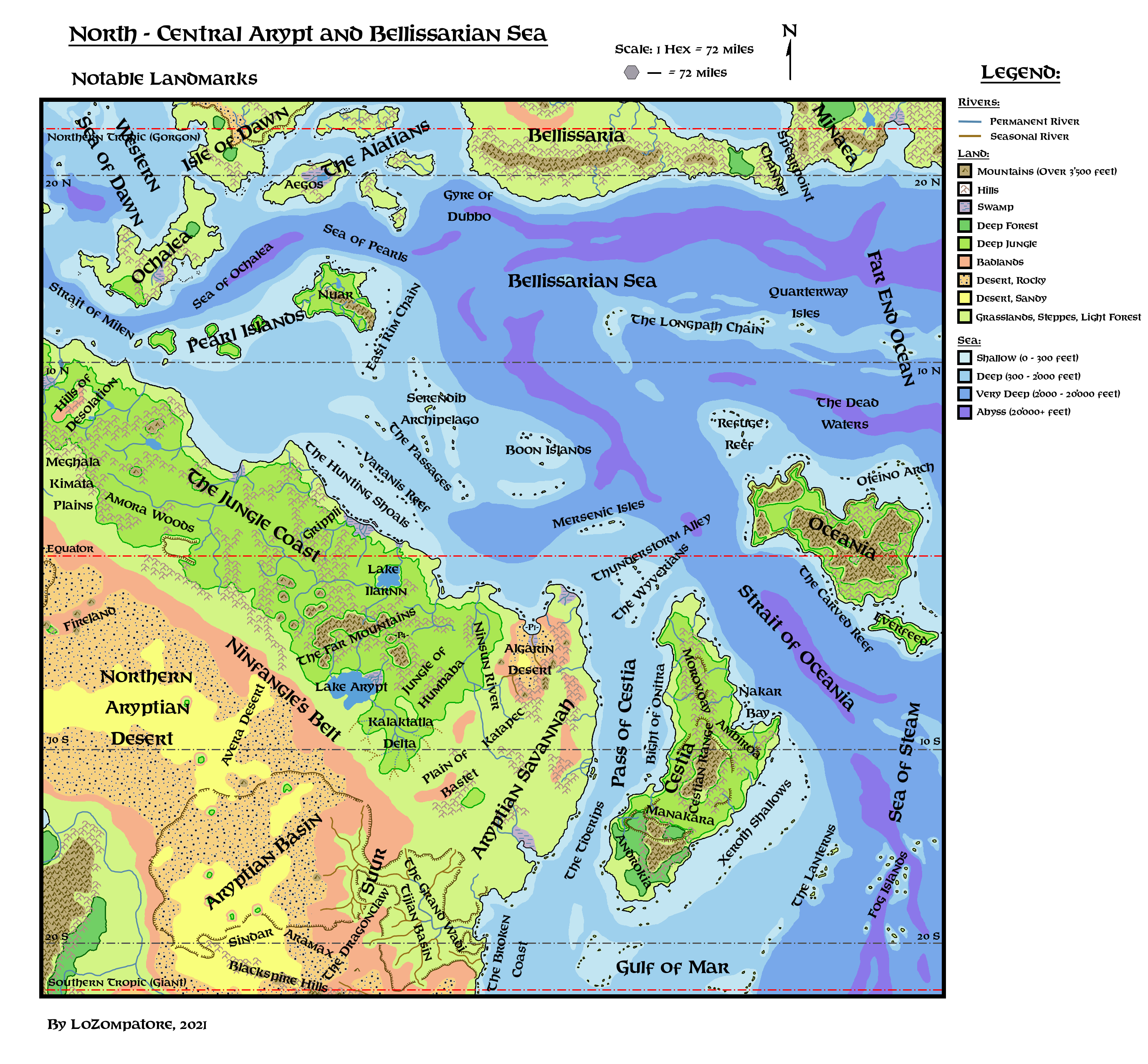
Comments:
Most landmarks in this map come from established canon and fanon sources listed above, to which I added several new ones based on the additions I made on the map.
A short description for the most notable landmarks and regions is provided below:
- Algarin Desert: From Dungeon Magazine #50 adventure. This desert is just south of a "V" shaped coastline so I think it fits perfectly with the coastline of northern Arypt. Elemental humanoid creatures made of sand called "desert ghosts" can be found living there. The desert extends for at least 3 navigation days in the East-West direction (at least 270 miles). There is at least a sandy patch in the middle of the desert in the south where the Rock of the White Flame (see) and the fortress of Nazir al-Azrad are placed. The sandy patch and the coastline desert have different landscapes at their horizons so they should not be in view of each other (I estimate they must be at least 60 miles away from each other). The resulting extent shown in the maps is a compromise between adherence to the abovementioned distance and the need to squeeze the arid lands between the jungle and the eastern coastline. Notice that if this idea by Bruce Heard for Arypt is considered then it is possible that the desert is just one of the two possible landscapes for the region, the other one being a more fertile prairie/savannah currently on an alternate reality that substitutes the desert at the right star alignments. In the ancient times of Lhomarr this part of the continent was ruled by the Oltec kingdom of Ilarnn, whose capital disappeared millennia before the Great Rain of Fire (see the entry about "Ilarnn Lake" for further details). It is possible that the ancient capital of Ilarnn resides in the alternate reality and is still inhabited by the descendants of its Oltec founders.
- Amora Woods: From Havard's map of the early Outer World Milenian Empire. The name of this part of the Jungle Coast corresponds to the same forest within the borders of the Milenian Empire in the Hollow World. As centaurs live in the woods of the HW Milenian Empire then this should be true also for the former Milenian territories of the Outer World. For this reason I figure the Amora Woods of the Jungle Coast are inhabited by its own sub-race of jungle centaurs.
- Aramax: From Dungeon Magazine #79. At the time of ancient Lhomarr this was a sub-dominion (a "barony") of the kingdom of Suur, its southernmost colony and the most civilized Oltec land south of the Inner Sea (the Aryptian Basin), with its capital in the city of Schadel. The first Oltec settlers who crossed the Aryptian Basin from the north believed they found a new continent, as they were not aware of the true shape of the Inner Sea. This beliefs survived for quite a long time during the early colonization of the land of Aramax. The Blackspire Mountains (see the entry about the Blackspire Hills below) represented the souther natural border of this dominion, separating it from the free lizardmen tribes roaming the plains of central Davania. At present time the land of Aramax is a mix of desert an arid shrubland, dotted by ancient ruins from the time of Lhomarr and of little value for most neighbouring people.
- Aryptian Basin: From HW Outer World Map and from Geoff Gander's map of ancient Lhomarr. This is a dessicated, salt plain surrounded by high cliffs; the western section is a true desert dotted with a few major oases, while the easternmost part is crossed by the occasional wadi (seasonal river) which helps the growth of shrubs and other xeric vegetation. At the time of ancient Lhomarr this basin was a sea (called the Inner Sea or the Aryptian Ocean) connected to the Gulf of Mar. The same geological uphevals that led to the sinking of the island-continent of Lhomarr raised the seafloor of the strait connecting the Tijian Ocean and the Gulf of Mar, with the side effect of preventing humind winds from reaching the interior of the continent. As a consequence, the Inner Sea dried up and turned into a desert in less than a millennium. A few large oases in the northern and western part of the basin include deep saltwater lakes where the remnants of the old marine ecosystem still survive. Those lakes are believed to be connected with the Elemental Plane of Water as they never dry up, irrespective of droughts; possibly the Immortals are involved in their creation and preservation.
- Avera Desert: From Dungeon Magazine #37. A sandy and forbidding extention of the Northern Aryptian Desert, this flat and mostly unexplored expanse is the dominion of Sis'thiks. A caravan route crosses its northernmost section, where the city of Balthazar was established as a neutra, free trade post between the desert dwellers and the inhabitants of the eastern plains. This part of the Avera desert is home to the Sandlings and to a cult of human dervishes which most likely descended from ancient Nithian mysticism. An ancient and important colony of Yuan-ti is hidden in the highlands west of the Avera Desert.
- Bight of Onitra: A sea lane on the western coast of Cestia with a lot of traffic from the south to the north, favored by a deep channel where sea current speed to the north increases. Navigation across the Pass of Cestia to reach the western Aryptian coast is also possible for skilled seafarers. "Onitra" is an ancient Cestian word meaning "Retribution"; people from Manakara gave this name to the coastline because local conditions enables them to bring the right retribution (wealth or war) to their cousins of Morovoay depending on the political climate at the time.
- Blackspire Hills: From Dungeon Magazine #79. Once a towering mountain range separating the Barony of Aramax (see) from the Free Lizardmen Tribes. The whole chain collapsed following the cataclysmic sinking of ancient Lhomarr and now most elevations barely register as hills. A few isolatd peaks still dots the Blackspire, usually volcanic in nature. Due to the ancient upheavals the Blackspire Hills are a treacherous land to cross, filled with canyons, ravines, unsteady piles of boulders and deep fields of sands. Albeit in a different form, they still represent a natural barrier between the Aryptian Basin and the Southern Aryptian Desert (aka the Forlorn Lands, see).
- Boon Islands: This name was given to the archipelago by the first explorers from Serendib, who followed old Milenian maps to reach these heavenly shores. The Boon islands are blessed by excellent weather, vey fertile and teeming with exotic goods. Inhabitants are of Mawa ethnicity (the same of the people living in the archipelago of Serendib), they are usually peaceful, friendly and willing to trade with outsiders. The Boon Islands also easy to navigate thanks to a good combination of sea currents and dominant winds, the same currents and winds that always prevented conquest or colonization by the people of the Aryptian coast. For centuries the Boon Islands remained under the benign sphere of influence of Serendib merchant houses. Thyatian officers from the Pearl Islands have always been aware of the Boon archipelago but they deemed the islandsl as too far away from the Empire for garrisons to be maintained. They resolved instead to force the guilds of Serendib to sell them the exotic goods of the Boon Islands at a reduced price. In recent times, however (after AC 965) the opening of new trade routes by the Alphatians led some venturing explorers of this empire to discover the Boon Islands, which lay along a favorable trade route from eastern Bellissaria. As the number of Alphatian ships from Spearpoint and Fort Ballarat increases in the Boon Islands, the guilds of Serendib become more and more upset, hiring corsairs to discourage their rivals. The Thyatians as well are planning to set their feet on the archipelago before the Alphatians do the same. This is one of the causes of the recent naval clashes between Thyatis and Alphatia in the eastern seas hinted in DotE.
- The Broken Coast: A logical assumption due to the raising of the Aryptian Basin after the sinking of old Lhomarr. The upheavals damaged the old shoreline and the surrounding seafloor, leaving in their wake tormented islands with steep coastlines and long stretches of jagged rocks protruding from the sea. In the following millennia corals added their own reefs to the shallowest sections, leading to a tricky environment for sailors and a haven for pirates. Notwithstanding, the Broken Coast sea lanes see a brisk traffic in the north-south direction due to favorable winds and sea currents which enable a quick crossing of the Gulf of Mar between Cestia and the Vulture Peninsula. Trade settlements are usually nested in the best free sections of the coastline.
- The Carved Reef: From this description by David Keyser. The only thing I'd like to add with respect to his description is the addition of some kind of guardian - living or construct (coral golems or living statues, anyone?) - placed there by Polonius, the Immortal currently protecting the carved reef. If not for the night dragons, there would be a favorable trade route linking Everfeed and the southern coast of Oceania, coasting the Reef for its whole length, with potential for experienced sailors to link to the northern tip of Cestia. The Reef itself is teeming with marine life and, likely, even with intelligent subsea races, provided they are outside the night dragons' businesses.
- The Dead Waters: A very dangerous body of water north of Oceania, surrounded by a vast gyre of sea currents and partially inside the Doldrums. A sudden change in the winds blowing from the north may lead a ship directed to the Refuge Reef (see) to enter the Dead Waters; once there it may become stranded for weeks before the right conditions to move on are met again. Sea monsters from the deep and even night dragons of Oceania may be tempted to periodically sift these waters for prey and food. Imagine this sea as the epitome of mystery and danger: usually calm, and seldom hit by random breezes, covered in seaweeds and debris, suddenly covered in fog banks or other strange atmospheric phenomena that can make a crew mad with despair, haunted by ghost ships and monsters. It is partially unexplored and may host lost islands with a population of stranded survivors or more eldritch inhabitants.
- The Dragonclaw: From Dungeon Magazine #79: At the times of ancient Lhomarr this high plateau was once a forest-covered peninsula separating the Aryptian Ocean (see the Aryptian Basin entry above) and the Tijian Ocean (see Tijian Basin below). When the Oltec colonists of the kingdom of Suur first reached the Dragonclaw peninsula they found it already inhabited by the elvish clan of Arbrenlyaan. These mysterious elves gladly allied with the kingdom of Suur and allowed the Oltecs to build their new capital here (the thriving city of Suur) but were very secretive about the inner territories surrounding their clanhold, which was impossible to find without an elvish guide. The origins of the Arbrenlyaan elves are shrouded in mystery as well; they were a peculiar clan indeed as, at the time of ancient Lhomarr, half-elves born from the Oltecs of Suur and the people of Arbrenlyaan were quite common. After the fall of Lhomarr and the dessication of the Inner Sea the forest turned into shrubland and savannah and both Suur and Arbrenlyaan were abandoned. The fate of the local elves is currently unknown.
- East Rim Chain: A long chain of small islands just offshore the southern and eastern coast of Nuar. Inspired by DotE and PWAs, where it is said that the Pearl Islands archipelago includes many smaller islands with respect to those shown in the maps. The East Rim Chain are inhabited by Nuari and are nominally under Thyatian control; in recent decades (after AC 965) they became contested grounds as Alphatian trade convoys sailing back to the Alatians from the south used these islands to shelter and resupply. This is one of the major reasons of recent conflict between Alphatian and Thyatian navies in the eastern seas, as hinted in DotE.
- Far Mountains: So named by the Milenians as they represented the mountain range farthest from the capital they managed to conquer at the height of their power. The chain has several other names depending on local cultures, but this is the one that sticks the most for people coming from northern Davania. The Far Mountains are the highest mountain chain of north and central Arypt, with an average altitude of 5500 feet and isolated volcanic peaks reaching up to 19000 feet. Most volcanoes are now inactive and glaciers dot the slopes of the highest mountains. The chain can be divided into three sections: isolated volcanic ranges of mid-altitude in the west; the main mountain arch in the central section, and a separate block in the eastern section. Most of the highest mountains of the chain are found in the eastern section of the arch and in the eastern block. Notables among the highest peaks are Whitemount, which is the seat of a large dwarvish clan; Astylis' Peak, home to a mad wizard, and Windcrag Mountain, a lone volcano sprouting from the valley separating the central arch from the easternmost block of the chain.
The Far Mountains act as a formidable barrier to wind circulation, intercepting humid flows from the northeastern seas and inducing a huge and semi-permanent amount of rain over the mountains; on the southern side of the mountain chain this rainfall is collected into the vast Lake Arypt (see), waters the Jungle of Humbaba (see) and periodically flows into the Kalaktatla Delta (see), while on the northern side it feeds Lake Ilarnn (see) and the surrounding jungle. On the eastern slopes of the chain winds are dried of humidity and often repelled back to the east, forming a peculiar micro-climate that contributes to the arid conditions of the northern Aryptian Coast. Magic at work on this phenomenon cannot be excluded.
Currently most of the chain is controlled by serpentines, the notable exception being the dwarvish community of Whitemount, which is often menaced and cut-off from the trade road to the coast by its dangerous neighbors. The western section of the mountain chain is inhabited by medusae and ophidians, and the central section by naga, medusae and yuan-ti; the eastern block falls into yuan-ti controlled zone, but it is totally unexplored. - Fog Islands: These islands are westernmost part of the unnamed offshore archipelago shown in Sturm's map here. I named the archipelago "Fog Islands" because they are placed approximately at the same location of the pre-cataclysmic Sea of Fog shown in HW maps. As this part of the world did not change too much before and after the Great Rain of Fire I assumed that this part of the ocean is still affected by extensive fog banks. I also split the islands in groups separated by a long abyssal trench, to add some detail and highlight their volcanic origin. A favorable trade route linking the tip of the Vulture Peninsula with Cestia passes in the middle of the archipelago; I figure out that the part of the route crossing the Fog islands is the most dangerous one, also considering possible attacks from lurking abyssal monsters and hostile native populations of the island.
- The Grand Wadi: The draining of the Inner Sea (see) following the sinking of Lhomarr did not completely desiccate the Aryptian Basin. Its easternmost part is washed by occasional rainfalls brought by the winds blowing from the Gulf of Mar; the humidity still left in the air after the coastal rainfalls then utterly precipitates when the winds from the sea cool down while climbing the steep walls of the Basin. As a result, a large network of seasonal rivers crosses the bottom of the Basin east of Suur, assuming the collective name of "The Grand Wadi" by local inhabitants. Only the main branch of the network collects enough water from its seasonal tributaries to be considered a proper, permanent river, which can also be navigated with small boats with flat bottoms. Millennia of seasonal deluges enabled the Grand Wadi to carve an estuary across the coastal highlands to the east; the coastal trading city of Kechamar (see) was built nearby. Most of the plains covered by the Grand Wadi are covered with savannah and shrub lands, quickly degenerating into arid badlands west of Suur. The Grand Wadi is mostly inhabited by the Bigfolks: Pachydermions, Rhinotaurs and Hippofolks share the river network in an uneasy cohabitation.
- Grippli (Land of the): Collective name of the land of the froglins, inspired by I11 module "Needle". In the module this is actually the name of a tribe of froglins, the most peaceful and traditionalistic ones (another notable tribe being the strongest and more aggressive Bullywugs). As the Grippli are the most likely trading partner for any explorer reaching this part of the jungle, I assigned this name to the whole land.
- Gyre of Dubbo: An important navigational spot for Alphatian traders between Bellissaria and the Alatians. With a clever exploitation of local sea currents and winds a skilled captain can reach the main eastern route coasting southern Bellissaria or the northern route to the Alatians and Alphatia, or exchange between the two. An unskilled captain may end up stuck for days in the middle of the Gyre, which is covered with floating sargasso and blown by weak winds. The end of an abyssal trench lays below the floating sargasso: creatures from the deep may be tempted to surface to see which kind of prey is stuck among the algae. Consider it a lesser dangerous (but still tricky) version of the Dead Waters (see).
- The Hunting Shoals: A vast and very dangerous stretch of shallows between central Jungle Coast and the Varanis Reef (see). Here strong dominant winds push toward the coast, while erratic sea currents in the shallows fill them with shifting, unmarked sandbars. The Hunting Shoals are so called because they are the hunting grounds of the lizardmen living on the coast, who never content themselves of the abundant fish available in the area. Any ship caught struggling in the sandbars trying to regain the open sea is inevitably attacked by the war pirogues of the lizardmen, who constantly row in the shallows, looking for loot and fresh meat. Targets that appear defenseless are openly attacked during daytime as a test of courage for the young lizardmen, while more menacing ships are ambushed during the night, usually once a larger number of pirogues is assembled.
- Lake Ilarnn: A large lake currently acting as a natural border separating the Algarite communities of the coastline from the dangerous settlements of the naga in the interior. The lake itself, as is the river from the lake to the sea, is placid and navigable, misleading explorers into reaching the lake's western shores, where the naga are waiting for them. So far only the newcomers to the region, the Alphatians, dared building a settlement on the mouth of the river leading to the lake. The lake is so called from the Oltec Kingdom of Ilarnn that stretched on Northern Arypt by the time of ancient Lhomarr. Jungle-covered ruins attributed to the ancient capital of Ilarnn stands on the western shore. In truth this lake was part of the nearby Kingdom of Orimul, and the ruins are of a city built by refugees of Ilarnn and Orimul when the Serpentine Empire invaded the Oltec Kingdoms in the wake of the sinking of Lhomarr. The city on the lake did not survive long the Serpentine encroachment. The few erudite aware of these events call the ruins "Nu-Ilarnn" meaning "Another Ilarnn" to emphasize the fact that the true - and still unfound - capital of ancient Ilarnn must be elsewhere (see the entry about "Algarin Desert" for further details).
- Jungle of Humbaba: Humbaba is cited on Master Set (DM's Manual pages 58-59) as a one-eyed monster defeated long ago by the hero Gilgamesh. The episode is inspired by the real world epic of Gilgamesh, where it is said that Humbaba was the guardian of the Cedar Forest, a magical place inhabited by the gods. Humbaba was placed there as a guardian, to scare mortals away from the gods �realm. In the Codex Immortalis Gilgamesh is placed in the Katapec region, together with his mother Ninsun, so I assumed Humbaba was an exalted being placed as a guardian to an Immortals' gathering place (the Temple of Ark, see) in the jungles to the west of Katapec. And so you have the Jungle of Humbaba: albeit the monster was slain millennia ago perhaps the region is still imbued with Humbaba's magic, populated by other guardians and still unfriendly to intelligent mortals, who tend to be scared away as they approach the Temple of Ark.
- Kalaktatla Delta: Kalaktatla is the name of the Immortal Ka the Preserved upon the Oltec people. I assume the huge delta flowing out of Lake Arypt, and the jungle surrounding the network of rivers, is a natural preserve where all kind of animals and ancient creatures (Saurials, for instance) may find refuge. Nearby Jungle of Humbaba and the Temple of Ark (see) help keeping hostile intruders at bay. Water in the delta might follow a seasonal pattern, when rains from the Far Mountains cause Lake Arypt to spill over ad flood the southern lands (mimicking real world Okawango Delta). In ancient times the Delta was an ordinary river draining into the Inner Sea (see); it represented an important trade route for the people of Orimul. Then, following the geologic raising of the whole Aryptian Basin caused by the sinking of ancient Lhomarr, the course of the river became interrupted and the inner delta was formed. The Immortal Ka took interest in the area shortly after the Great Rain of Fire, following the destruction of his sacred forest in northwestern Davania and trying to find a replacement where to shelter creatures endangered by the Cataclysm. Since then the region lays under his discrete protection.
- The Lanterns: A chain of quite large volcanic islands, approx. one third of the way between Cestia and the Isles of Steam. The Lanterns are so called because they are formed by pretty high, semi-permanently active volcanoes: the fires from the top of the mountains is a useful navigational aid for ships crossing the Sea of Steam and the Fog Islands. The main route from the Varellyan Peninsula to Cestia touches the southernmost of the Lanterns, where ships usually resupply for the last leg of their journey.
- The Longpath Chain: A stretch of volcanic islands on the mid-oceanic ridge of the Bellissarian Sea and of the western Far-End Ocean. The archipelago is so-called because it was used by the Nuari around 1000 BC to safely migrate across the sea from Skothar, hopping between islands. Descendants of the Nuari who did not follow their brethren to the Pear Islands still inhabit the many atolls and volcanoes of the Longpath Chain. The Quarterway Isles (see) are part of the Longpath Chain but, as they are part of an important trade route between Bellissaria and the Jungle Coast, are populated by a melting pot of people with Nuari, Milenian, and Alphatian ascendance, calling themselves the Black Kuna.
- Mersenic Isles: An archipelago of small islands close to the northern Aryptian coast. It is placed in the middle of the local Doldrums, so it represents an extremely useful stop for ships to resupply and wait for winds to blow again in the right direction. For this reason the islands were colonized by all seafaring cultures of the area and its inhabitants are a true melting pot of different races. Locals collectively refer to themselves as the "Brown Kuna", as they are connected to the other Kuna people of the old Milenian route between Bellissaria and the Jungle Coast. The name of the Mersenic Isles comes from the ancient Milenian noble house of Merse, an enterprising and powerful family of magic users and seafarers who dominated local trade at the height of the Milenian power and later - after the fall of Milenia - migrated to Alphatia, to establish the House of Merse in the kingdom of Theranderol.
- Ninfangle's Belt: This is a vast semi-arid plain wedged between the Jungle Coast and the Aryptian Desert. Rakasta (especially Caracasta, Pardasta and Simbasta) are the dominant race here. This plain was extensively used by the armies led by rakasta hero Ninfangle (later ascended to Immortality) to outmaneuver and defeat his Serpentine enemies (see also the entry about Ninfangle in the Codex Immortalis for details). Once defeated, Ninfangle led his people to settle in the region, separating the Sis'thik and the Yuan-ti of the Aryptian Basin from the bulk of the Serpentine Empire. Currently the plains are a pacified zone, crossed by an important trade route connecting Polakatsikes to the Aryptian Basin and patrolled by nomadic clans of rakasta; notwithstanding, hateful raids from surrounding Serpentines are not unknown.
- Ninsun River: According to the Codex Immortalis' entry about Ninsun, this Oltec mage established the kingdom of Katapec together with her son Gilgamesh, building the first crystal pyramids. I assumed the major settlements of the ancient Katapecs (together with their crystal pyramids) were built along the longest navigable river of the region which I aptly named after Ninsun. According to PC2 the tabi were the first to discover and explore the crystal pyramids after the fall of ancient Katapec. As from PC2 tabi live only in the jungle then it has to be assumed that the lower course of the Ninsun River became covered by jungle only after the fall of ancient Katapec.
- Oteino Arch: From here the Oteino are assumed to be the first Oltec sailors who migrated west from Skothar in times almost beyond memory. One of their first stops would be in the offshore islands northeast of Oceania, which somehow kept the original name of their colonizers over the millennia. The island chain is in the middle of local Doldrums and away from useful trade routes, so local culture here was barely influenced by surrounding events, including the Great Rain of Fire (climate remained more or less the same before and after the Cataclysm). The islands are still populated by long-removed descendants of the ancient Oteino, with some influence of later Oceanian culture.
- The Passages: An important shallow sea between the Varanis Reef (see) and the Serendib Archipelago. Here fast sea currents help moving from the Aryptian Coast to the Pearl Islands, while dominant winds push ships toward the Varanis islands. Skilled sailors will exploit the winds to reduce travel time to the Pearl Islands, the not experienced ones will end up in the Varanis Reef or, worse, enter the dangerous Hunting Shoals (see). Currently there is a wrestle for control of the Passages between the ships of Serendib and the Alphatian trade convoys, another part of the struggle for the eastern seas after the East Rim Chain (see) and the Boon Islands (see).
- Plain of Bastet: According to the Codex Immortalis, in times before history Bastet was the mother of all rakasta together with his spouse Kum-rah. According to the most ancient traditions of Simbasta and other rakasta of Arypt, the Plain of Bastet is where the couple lived most of their mortal life. This is a sacred land for many rakasta and actively defended by local nomadic Simbasta who styled themselves as guardians of Bastet's cult. The plain is also an important junction point between the trading city of Katapec and the western lands leading to Ninfangle's Belt (see) and the Grand Wadi basin (see). Guardian Simbasta in the Plains of Bastet stop all caravans crossing their lands and carefully question the travelers to assess their true intentions. Often some kind of tribute is requested (not always of practical value) to allow the merchants to proceed.
- Quarterway Isles: A group of islands part of the larger Longpath Chain Archipelago (see). The Quarterway Islands are so named by Alphatian sailors because a ship travelling between Spearpoint and Balfour's Landing on the Aryptian Coast will have covered approx. a quarter of the total route once it reaches the islands. In ancient times the Quarterway Isles were part - together with Refuge Reef (see) and the Mersenic Isles (see) - of a Milenian return route connecting their colonies on Bellissaria and Minaea to the bulk of the Milenian Empire on Davania. After the fall of Milenia the route was not used for many centuries and people stranded in the Quarterway Isles formed their own ethnic group of the Black Kuna, a mix between Milenian and Nuari stock. After the opening of the Alphatian routes to the south (AC 965) the Quarterway Isles saw an increase of Alphatian immigrants who built small villages and harbors to resupply the passing convoys.
- Refuge Reef: This is a large archipelago of countless islands and peculiar reefs scattered over a vast shallow sea northwest of Oceania. Strong winds blowing from the north discourage raids from the night dragons of Oceania; additional protection is provided by the above water protrusions of local corals, which often produce pillars and arches up to 150 feet tall. Ships may easily hide in the most labyrinthine part of the reefs, if targeted by some menace from the air, then can move to resupply in local volcanic islands. As the name suggest, Refuge Reef has historically been a safe haven for travelers crossing the southern Bellissarian Sea; this always included pirates, thanks to the practical impossibility by nearby countries to patrol and control the whole archipelago. Stranded Mawa and Nuari from the east were the first settlers of the Reef. Later, many Oceanians fled to the Reef when their island was conquered by the night dragons, forming the bulk of the local population. Then the Milenians established there several resupply bases as part of their long trade route from their Bellissarian colonies. After the fall of the Milenian Empire the route fell into disuse and local people were forced to fend for themselves for many centuries. A mixed ethnic group formed and became the so called "Red Kunes", due to the reddish color of their skins from blending of Oceanian and Milenian stocks. Currently a new trade route between Bellissaria and the Aryptian Coast was established there by the Alphatians. Provided Alphatian ships from the Quarterway Isles (see) do not get stranded in the Dead Waters (see) they may find a welcome stop at Refuge Reef before sailing south west to the Mersenic Isles (see). Alphatian traders and settlers are increasing in numbers in the Reef, as they could also represent a good staging point toward the rich Boon Islands to the west (see).
- Serendib Archipelago: This long archipelago is the seat of Serendib and the keystone power in the western Sea of Bellissaria, as the islands form an almost uninterrupted chain between the Aryptian Coast and Nuar in the Pearl Islands. Local winds and sea currents promote trade in both directions and also connects with the rich Boon Islands (see). This has made the people of Serendib (the ruling class from Minrothad, at least) incredibly wealthy, as exotic goods are a most-sought commodity in the markets of the Thyatian Empire and Minrothad. The islands were settled in ancient times by M-Polynesian Mawa people then, sometime before AC 500, merchants of Minrothad established there a large base of operation (Serendib) to exploit trade with the lands of Arypt while the Thyatians and Alphatians were busy fighting each other. Albeit the archipelago is formed by hundreds of small and large islands, the Master Merchants of Serendib have visited most of them during their careers, so they are not easily fooled by local pirates and competitors. Some of those captains get bored of legitimate trade activities and choose to become corsairs to hunt and expel from the islands all ships not aligned with Serendib's interests. In recent times these corsairs largely increased in number, due to increased pressure from Alphatian convoys crossing the nearby waters.
- Sindar Desert: From Dungeon Magazine #79. This was a sandy desert at the time of ancient Lhomarr and is a sandy desert now. As it is possibly one of the most ancient deserts of Mystara, located quite in the middle of a vast dry region of Davania, it could be the place chosen for the periodical conclave of all blue and sapphire dragons mentioned in AC10 (page 4), where the dragons compare the size of their hoards and compete for the gift to be elevated at the courts of their Immortal patrons.
- The Southern Aryptian Desert (aka The Forlorn Lands): From VotPA Part 5 and Part 6. This is the southernmost part of the Aryptian Desert of Davania, south of the Blackspire Hills (see) and extending to the Gulf of Mar. In its western section the desert is crossed by a branch of the mighty Kenathon River, which makes local land fertile and suitable for settlement. To reconcile with HW Outer World map that show grasslands and plains in place of the eastern section of the desert, it could be assumed that these lands - once green and fertile - were involved in the same curse cast by the Immortal who, in AC 965, turned the Varellyan Peninsula into a desert. The fanon name "Forlorn Lands" would be aptly assigned to this territory, which was once part of the thriving Varellyan Empire and was later abandoned, save for semi-nomadic Meghaddaran tribes. It is possible that, should the curse of Varellya be lifted, also these lands may gain back their previous climate pattern and become green again.
- Thunderstorm Alley: An empty stretch of sea connecting Oceania with the north-eastern tip of the Aryptian Coast. The Thunderstorm Alley gives its name to the periodical, vast storm fronts that develops in Oceania and then drift to the Aryptian Coast. Night Dragons and their minions are known to fly in trail of some of the most violent storms when they whis to raid the lands of Cestia and of the northeastern tip of Aryptian Coast, spreading chaos and terror in their wake. The inhabitants of the Wyverian Islands (see) which are the most exposed to their attacks, developed the most effective measures to counter their raids, most of which were copied by the people of Cestia.
- The Tiderips: According to HW Pre-Cataclysmic Map this part of the Pass of Cestia was once an isthmus connecting Cestia to the Davanian continent. After the Great Rain of Fire the isthmus collapsed leaving a shallow and broken seafloor, which is often the source of unpredictable currents and whirlpools. Moreover, according to VotPA, this part of the sea is often hit by thunderstorms and bad weather. For all ships going south the Tiderips are by far the most dangerous part of the crossing, to be completed in the fastest possible way.
- Tijian Basin: From Dungeon Magazine #79. A flat basin covered in savannah, crossed by demi-permanent wadis and surrounded by sheer cliffs. Close to the Gulf of Mar the wadis turns into proper rivers and carve deep canyons before reaching the ocean. At the time of Lhomarr this was the eastern part of the Inner Sea, connecting the Aryptian Ocean with the Gulf of Mar. The sinking of Lhomarr caused the raising of the seafloor of most of the Tijian Basin, disconnecting the natural seawater flow between the Inner Sea and the oceans of Mystara. The Tijian Ocean dried up in a few centuries, but the former seafloor remained somewhat productive thanks to the sparse but constant rainfalls from the Gulf of Mar. A large networks of wadis (seasonal rivers) cross the Tijian Basin; they provide sustenance for most of the Bigfolks (Pachidermyons, Rhinotaurs and Hippofolks) who established in the region since the sinking of Lhomarr. The important trading city of Kechamar lies on the coast of the Tijian Basin: here goods from the interior are exchanged with supplies brought by the many merchant vessels coasting the Gulf of Mar between Cestia and the Varellyan Peninsula.
- Varanis Reef: So named by the ancient Milenians for the large lizards living on the islands of this long reef, and also as a play of words because in Milenian language the word "varanis" means "warning". The Reef acts as a warning for sailors moving on the southern Bellissarian Sea, as spotting the island chain at the horizon means that the ship got too close to the continent and is at risk of entering the dangerous Hunting Shoals (see). The Varanis Reef itself is not as dangerous as the Hunting Shoals, because the fragile war pirogues of the lizardmen often capsize and sink in the relatively high sea around the Reef. At least the southernmost section of the Varanis chain is safe enough from lizardmen raids that it is possible to resupply on the islands. Both the Alphatian convoys and the ships from Serendib exploit this opportunity, albeit in different sections of the chain (the Alphatians, being newcomers, getting the worst choice) to avoid crossing each other's paths as much as possible.
- The Wyverians (Wyverian Islands): The Wyverians are mentioned in Dungeon Magazine #63 adventure "Beauty Corrupt" as a northern neighbour of the people of Orchid's Bay. I placed them in the archipelago between Cestia, Oceania and the NE tip of the Aryptian Coast. The inhabitants are mostly Algarites with large minorities of Cestians and Kunes. The Wyverians are well represented in the Algarite and Cestian trade routes, as their archipelago is an almost obliged stop for those involved in local oceanic trade. The islands are well within the local Doldrums, so the inhabitants do not rely too much on wind when moving on the sea. Due to night dragons' raids trhough the Thunderstorm Alley (see) people of the Wyverians were forced to adopt a warlike attitude merely to survive the attacks, and developed a whole range of magic and mundane defensive weapons against dragons, most of which were also copied by the Cestians.
- Xeroth Shallows: This expanse of shallow water south east of Cestia is the main fishing ground for the whole island. The name for the Shallows is a corrupted form of "Xerothnyi", the ancient name of the pre-cataclysmic Cestian Peninsula by the time of old Lhomarr, albeit now very few in Cestia remember the origin of this word. The word survived through the ages thanks to sea giants and other long-lived creatures inhabiting the seafloor. Several important sea routes from the southeast cross the Xeroth Shallows; winds are strong and pushing toward the Cestian coast but, usually, local sea and weather conditions are benign enough to enable ships to anchor in the Shallows and trade with undersea communities.
A fan-made Atlas of Arypt Part 5: People and Races
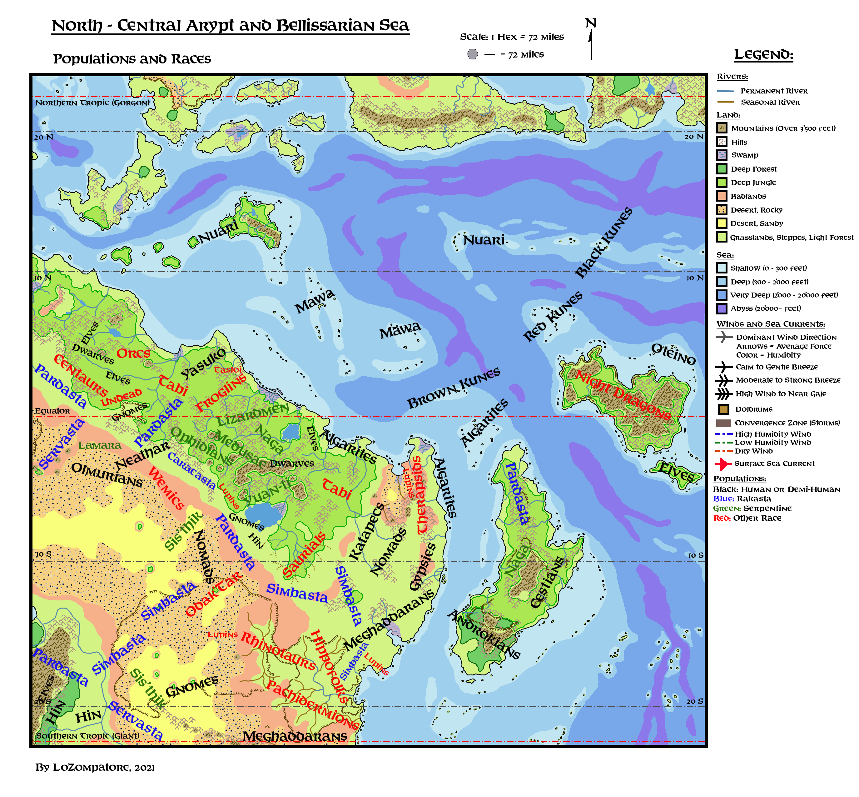
Comments:
In the following a list of notes about several fanon populations, including some new ones I just added into the setting.
To the list I included also some remarks about several small enclaves of dwarves, elves, halflings and lupins because I feel unrealistic there are none of them in such a vast area (see Part 2 of this Atlas for insights about the extent of the region), and because it is useful to have some of these places for PCs generation when running adventurers.
- Algarites: These are the Berber-like inhabitants of north-eastern Arypt, living mostly in scattered city states along the coast between Nandua and Galgaboth, with offshoots in Balfour's Landing, Garth and the Mersenic Isles. They are also spread along the caravan routes of the interior, mostly living a nomadic lifestyle (see "Nomads" below).
I named this people "Algarites" as Algarin was the major settlement of the region according to Dungeon #50 adventure "The object of desire"; it ruled over nearby cities up to 500 years ago and the local desert is named after this settlement. So I guess it could be a good name for the local population, too.
Algarites are trade-oriented, as local climate and geography induce some scarcity of foodstuff and of several other basic goods, which the Algarites are forced to find elsewhere. Despite this, a few Algarite towns and several individuals are very rich. Their culture and racial traits should be similar to Earth's medieval inhabitants of the Mediterranean coast of Africa (from Morocco to Libya).
I am intentionally vague about origin and ethnicity of the Algarites, to give room for further development. Algarites may be a blend of different races (Oltecs, Milenians, Nithians, Katapecs, etc.) who mixed over the centuries following the upheavals of history; they could be related to a splinter group of Alasyians; they may be the original stock of people brought on the Isle of Dawn by the Nithians and who later moved to Ylaruam; they may be a more urban branch of the Meghaddarans as suggested by Christian Constantin here (end of his article); they may have a totally different origin from the ones listed above.
A couple of notes about Algarites' history: according to Dungeon #50 adventure the dominion of Algarin over nearby settlements (Sasan and Samarkand are mentioned) ended some 500 years ago, when the last ruler of Algarin was turned into a beholder by the evil mage Nazir-al-Azrad, causing the fall of the capital of Algarin and the independence of its subject settlements. Moreover, this part of the world should have been under Milenian rule, approximately between 500 BC and 100 BC. - Bigfolks: A collective name to indicate Hippofolks, Pachydermions and Rhinotaurs, who inhabit the eastern section of the Aryptian Basin and form the largest part of the population of the coastal city of Kechamar. The three races are usually neutral toward each other, to preserve the much-needed trade routes with the lands outside the arid Basin, albeit local conflicts are not unheard of. For further information see the separate entries in this list.
- Dwarves: Basically I added two dwarvish communities to the region: the Boulder Clan from I11 module "Needle" and the people of Whitemount Clan from AC1 "Shady Dragon Inn" (page 18). The Boulder Clan is made by very active and restless people and may actually be ruled by female dwarves (see I11 page 17), while Whitemount dwarves should be mostly concerned with good mine-building, ale-drinking and storytelling. The coat of arms of Whitemount may be two crossed pickaxes, according to AC1. Dwarvish names for both clans are "Gloden" (Boulder) and "Syrrast" (Whitemount), as derived from GAZ6 . Both communities left Rockhome in BC 450 and BC 370 respectively, following Milenian conquests along the Jungle Coast and Northern Arypt. Following Milenian decline the two clans did not renew their allegiance with the Milenians and retired in their fortified mountains. Later the dwarves traded with local communities and fended off the new threats left by the fall of Milenia (mainly Bogdashkan Orcs for the Boulder Clan and Yuan-ti for the Whitemount Clan. With the rise of Algarite communities the Whitemount Clan became the prominent source of good weapons, armor and tools for the whole coast, leading to the establishment of the human kingdom of Rhyl to act as intermediary. Boulder Clan dwarves are less involved in trade but they form a strong, expanding community and its members like to explore the surrounding world and go adventuring.
- Elves: I added three small communities of elves in the Jungle Coast. Two of them were already briefly introduced by me here while the third one is based on the merry elves of AC10 adventure "Ravellia and the Dragon Eggs". I named the three clans (from the easternmost to the westernmost one) "Telwa" (canopy wind), "Thalasir" (tranquil flow), "Aldareth" (tree-climbers), the last one referring to the clan of AC10 module. All three clans are splinter groups of the second elvish migration from Grunland. They settled their current locations on the Jungle Coast between BC 2100 (Telwa and Thalasir) and BC 2000 (Aldareth). The Telwas are the most urbanized community among the three, due to their proximity with the ancient capital of the Milenian Empire. For centuries they provided scouts and rangers to the Milenians and came to adopt some of their improvements in architecture, machinery and alchemy. After the fall of Milenia they retired in their lands, sporadically sending parties to scavenge the ruins of metropolitan Milenia. During this time they always were in good terms with nearby Manacapurus, as both people wished to be left alone. Only recently, with the Thyatian colonization of the Hinterlands, the Telwas started sending adventurers and traders outside their ancestral territories. They possess much ancient Milenian works of art and lore, and they know they could get a good price for them.
The Thalasirs are river-dwellers and they live dispersed in several small villages along the branch of a major river of the jungle. They lack a central settlement, and decisions are taken by a council of representatives from all villages who gather at the settlement which will mostly be affected by their decision. They were allies of the Milenian Empire and provided much river trade among the cities of Pelai, Pharos and Iossa (all of them now in ruins). They were and they are still in touch with the dwarvish Boulder Clan (see the entry about Dwarves in this list), which they helped with the export of their goods. Currently the Thalasirs live on the defensive, as Bogdashkan orcs frequently harass their communities; the only advantage for the elves is their ability to outmaneuver orcs movements thanks to the river.
The Aldareths are a clan of wild, merry elves who live in the jungle between Lake Ilarnn and the coast. They are not evil, but they are a no-nonsense kind accustomed to driving intruders outside their territory. Their biggest enemies are the Naga living across the lake, which often try to infiltrate their lands. The elves keep open trade routes with the people of Nandua (which they do not trust too much) and Shebal, exchanging elvish crafts, jungle herbs and ingredients with exotic goods and iron tools. At times, parties of Aldareth elves cross the lake and explore the ruins of Nu-Ilarnn; albeit a very risky business, sometimes they managed to bring back invaluable treasures from the ancient city. In recent times, the Aldareths found themselves in bad terms with intrusive Alphatian magic-users from Balfour's Landing, which enter their lands uninvited to explore the interior. - Froglins: Frog-people from I11 module "Needle". At least two different clans/sub-races are mentioned: the smaller, peaceful, traditionalist Grippli and the larger, stronger, more aggressive Bullywugs. Both groups venerate the ancient ruins of the Needle, where a city was built in time before human history to trade with the planar spiders of Chack, who have an outpost on Matera. The city fell to civil war and the trade route was closed ages ago. I guess that while the Froglins cannot be included among the Serpentine Races, at least the Bullywugs can be persuaded to join at times the Serpentine Empire given the right incentives.
- Gnomes: I added two small gnomish communities at the fringes of the Jungle Coast, located around the ruins of the ancient Snarta I and Snarta II cities (from here). Both communities are made of Snartan gnomes who did not follow their kin to the subsequent step of their migration to the south, for this reason they did not turn into the Snartan society of clones currently thriving in the Vulcanian lands and are more similar to the standard gnomish stock. The northernmost community is made of the "Burrowing Gnomes" and is the most ancient, albeit the smaller, one; local gnomes live inside the tunnels they carved over the millennia in the plateau of Snarta I, which they inhabited since BC 1200. These gnomes are sly, distrustful and very traditionalist, following incredibly old customs from before their migration across Davania, with just a film of "modern" Milenian novelties added to them. I figure that Digger, the NPC from I11, might come from this place.
The southernmost community is based around the ruins of Snarta II on the shores of Lake Arypt, and is made by the so-called "Lakers Gnomes". These people are way more open-minded and trade-oriented than their Burrowing cousins, albeit more militaristic and still distrustful of strangers due to the Serpentines living just across the lake. The colony of Snarta II lasted mere 60 years until it was abandoned in BC 543 by the bulk of the Snartans. Here the gnomes learned seafaring techniques (Milenian style, see the original article about Snartans to have a look at their galley-like machines) and also they gathered enough resources serving the Milenian armies to build a new Earthshaker with which they crossed the Aryptian Desert back to southern Davania. The Snartans who decided to stay liked Milenian culture (albeit it did not last very long) and seafaring, and these features are still present among the Lakers Gnomes. Currently they are in close ties with the Hin of Baybluff (see the entry about halflings in this list) and often are part of the local caravans on the west side of the jungle. These gnomes are in good terms with the local Lupins to the west (Gnomish Snoutzer sub-race, see also the entry about Lupins in this list), which they helped survive in the jungle (see Dragon #237 "Lupins of Mystara", entry about the Gnomish Snoutzer). - Gypsies: Introduced in AC11 "Book of Wondrous Inventions", page 82. Connected to the Algarites as detailed in Part 1 of this Atlas. Gypsies may be related to Algarites or Meghaddarans but, likely, they form their own ethnicity given the fact that gypsy women possess some innate magical powers. Quoting from AC11: "These travelling folk roam the lands in brightly-painted wagons. They are close-knit and dislike strangers. Rumor has it that the gypsy women possess magical powers, and especially the ability to see the future. It is also rumored that the women can curse those who annoy or harm the gypsies".
- Halflings: I added a hin community along the southern shores of Lake Arypt, built around the halfling town of Baybluff. These halflings migrated from the southwest around BC 550; they crossed the Aryptian Desert to reach the lake, lured by the splendor of the Milenian Empire at its peak. They wished to trade and they never stopped doing so, even after the declining Milenians abandoned them, under pressure of their many enemies. In the centuries since the halflings of Baybluff hardened into a shrewd, resolute people, able to keep open the original trade route across the Aryptian Basin, to trade on equal terms with the rakasta of the plains and to fend off naval attacks by the Yuan-ti across the lake. They are allied with local Snarta II gnomes and in good terms with local pardasta, which often are hired as rangers and guides. The fortified town of Baybluff - on a steep coastal hill dotted with burrows where large hin families make their home - is a most-sought stop for caravans crossing the endless plains and deserts of this part of Davania. I figure that the uncompromising PC called "The Ghost" from I11 module comes from this place.
- Hippofolks: An addition I made to the Aryptian Basin, which is already populated by Pachydermions and Rhinotaurs under the collective name of "Bigfolks". Aryptian Hippofolks follows the description of their AD&D counterpart, albeit they are far lesser urban and without explosives (or with explosives, if you like to differentiate them a bit from the surrounding cultures). They live in villages along the most well-watered plains of the Grand Wadi, and they form a large part of the inhabitants of Kechamar. Hippofolks train common hippopotami as pets and work animals and they are a dangerous foe if annoyed, albeit less hot-tempered than the Rhinotaurs. They are in touch with the Simbasta to the north and control the southernmost part (the fluvial one) of the important trade route connecting Kechamar with Baybluff and Katapec. Hippofolks are in an uneasy cohabitation with Rhinotaurs and Pachydermions, and clashes are not uncommon.
- Kunes (Black, Red and Brown): I made up these people to populate three island chains on the eastern and southern Bellissarian Sea. These archipelagos are placed on the same advantageous trade route from Bellissaria to the Aryptian Coast so, over the centuries, several cultures established outposts there, mixing with the existing inhabitants. The word "Kunes" comes from the ancient word "Koine" (common), given to the local mixed ethnicities by the Milenians when, at the peak of their power, established several naval bases on the islands. Over few centuries of Milenian domination, people on the three archipelagos came to adopt a common language and similar cultural traits, albeit local differences on skin color (with black, red or brown complexions from north to south, respectively) and other somatic features persisted. The Milenians added their own traits to the mixture of these people then, after the fall of Milenia, this trade route was abandoned and the three archipelagos became separated again for almost a millennia. Albeit the ancient common culture (tolerant, welcoming of strangers and avid of novelties) can still be recognized, today the Kunes are more differentiated than in the past.
The Back Kunes of the Quarterway Isles share an Oltec/Nuari/Milenian heritage; they are the most martial and enterprising, accepting in a glance new trade opportunities provided by the Alphatians when they re-opened the ancient Milenian route in AC 965.
The Red Kunes of Refuge Reef are an Oltec/Oceanian/Milenian blend; they are a suspicious and reserved people, always vigilant against night dragons' raids. They are also a resourceful kind, as they are forced to use the environment at their advantage to defend themselves and their families from aggressions by the evil dragons. Red Kunes are elusive and difficult to subdue; that's why the Alphatians preferred to make local agreements and establish there a few outposts for their ships instead of conquering the archipelago.
The Brown Kunes of the Mersenic Isles are a mixed Oltec/Milenian/Algarite group. They are skilled sailors and good merchants, used to the unpredictable winds of the doldrums and totally included in the Algarite trade loop. To an external observer Brown Kunes looks like eccentric Algarite seafarers, the most "civilized" of the Kunes people. In truth this is only a facade the Brown Kunes put on to ease trade with the Algarites and the merchants of Serendib; their "true" culture shares a lot with those of the Red and Black Kunes and the language is still mutually intelligible. As the archipelago is already dotted with outposts and resupply bases, the Alphatians there just asked for permission to use the existing facilities (at a good price). - Lupins: I added three small communities of Lupins on this part of Davania. Albeit they are not listed in Dragon #237 article about lupins I think that at least these three groups should be added for logical reasons. The intent is also to add the possibility for players to include lupins among local PCs, if they wish.
The first group, in the Aryptian Basin, is made of Fennec Fighting Lupins, a sub-race adapted to desert conditions. They would live along the trade route crossing the Basin, acting as middlemen between the Simbasta to the west and the Rhinotaurs to the east. Enterprising Fennecs may join local caravan and reach faraway locations in central Arypt, including the coast.
The second group, in the eastern part of the Algarin Desert would be made of Nithian Ramblers. These lupins were brought here by Nithian settlers and became stranded on the area after the Fall of Nithia. Albeit influenced by the Spell of Oblivion, they likely have the largest knowledge about the ancient failed Nithian colony which was established in this land. Currently the Nithian Ramblers of Algarin have some trade with the Algarites and can be found in all nearby cities.
The third group, in the savannah just north of Vanya's Rest, is a new addition to the region, brought by Heldannic Knights in the last 35 years; it is made of Doggermen and Das Hund sub-races. They are used as auxiliaries and support by the Knights in their attempt to establish a strong foothold in the region. A few of them left their sponsors due to boredom or old age and moved in nearby settlements such as Garth and Kechamar. - Mawa: This fanon M-Polynesian people was detailed for example here, here and here. The Mawa are the ancestors of the Makai people of the Ierendi archipelago, and were the original inhabitants of the Pearl Islands before being assimilated by the Nuari in BC 1000. I populated with Mawa the Boon Islands and the Archipelago of Serendib. I assumed also that in ancient times the Yasuko Tribal Lands were also inhabited by a Mawa offshoot (see here). Serendib and Boon island chains are away from major migration routes and form their own trade loop so they are not so much influenced by surrounding people, that's why the Mawa were spared the multiple cultural contaminations of the Kunes (see). The only major influence they suffered in the last 500 years come from the Minrothad merchants of Serendib, which are relatively few in numbers and mainly interested in making money. As a rule of thumb, Mawa people are friendly, peaceful and with a very traditionalistic attitude, even if their neutrality towards other people may lead them to give shelter to pirates and corsairs. The Mawa are good seafarers and excellent fishermen; their ancestors from Skothar used to cross whole oceans to reach faraway lands but, nowadays, the Mawa of the Bellissarian Sea are more concerned with local business. Apparently, they lost the knowledge to build true ocean worthy ships.
- Meghaddarans: Fanon people, likely created by Geoff Gander here and developed a bit here and here. I assume Meghaddarans are descendants of people conquered by the Empire of Varellya outside the Vulture Peninsula, living mostly in the southern half of the Aryptian Savannah and further south, in the Forlorn Lands. The two groups may belong to different - or just loosely related - ethnicities. After the destruction of Varellya these people turned to a mostly nomadic lifestyle, prizing horses and raids over the building of settlements and trade. The northern group of Meghaddarans is hostile both to the Heldannic Knights of Vanya's Rest and to the local Prides (clans) of Simbasta. They may include in their numbers also the descendants of the fallen Varellyan city-states of Shuriit and Yariin. It is also possible that the northern Meghaddarans share the same ancestry of the Algarites (see), the latter turning into a more urban people thanks to trade and influence from Cestia and Serendib. The southern group of Meghaddarans may have a different origin with respect to their northern cousins, as before the destruction of Varellya of AC 565 the Forlorn Lands (aka Southern Aryptian Desert, see the map in VotPA part 5) were once a fertile plain dotted with forests (by comparison of VotPA and HW maps of the region). So it is possible that the Southern Meghaddaran Clans were once a civilized people, forced to barbarism and a nomadic life due to the curse placed upon their land, which became arid and sterile. Some of them may be related to the fallen Varellyan city state of Baghdaan, albeit this settlement is in between the northern and southern Meghaddarans.
- Nomads: These are basically nomadic Algarites living in the savannah and grasslands of northern Arypt. They are mentioned several times in Dungeon #50 adventure "Object of desire", especially close to the Rock of the White Flame and to the Fortress of Nazir-al-Azrad (who captures the nomads and use them to feed the life-extending crystals created by the White Flame). I assume these nomads are mostly M-Berber herders and traders, leading caravans across the arid lands connecting the Algarite city states on the coast. They should also act as middlemen with the Katapecs, the Simbasta and the Gypsies, possibly pushing their caravans as far as Lake Arypt.
- Odak'Tar: A fanon population created by Alex Benson here. They are an hybrid between humans (Nithians) and Yuan-ti. The original Nithians who inhabited the oasis created by the Immortals in AC 500 may be refugees from the fall of the Ivory City or they may be settlers of their own nearby lost colony, established at the time of major Nithian expansion in the world (between BC 1100 and BC 1000). They could also be a mix of "worthy" Nithians of various origin magically collected and transplanted there by the Immortal Pflarr.
- Ophidians: Mentioned here and here as a possible addition of the snakemen people of Mystara. Here I included them at the fringe of the Serpentine Empire as an ancient threat of the gnomes of Snarta I and as potential rank-and-file soldiers of the Serpentines.
- Olmurians: Barbaric descendants of the ancient Oltec kingdom of Olmur; they were introduced by Christian Constantin here and expanded a bit by me here. I figure present-time Olmurians as the archetypical fragmented barbarians roaming the Aryptian Desert (as shown in Mentzer's Master Set map), capable both of great deeds and great tragedies. A distinction between proper Olmurians and Oltecinidians was made in both references above, where later Neathar migrants were considered. In map above all these additional people are not shown for the sake of clarity, but assume they are still present, included under the tag "Olmurians".
- Oteino: Created by Sturm as an early Oltec population and described for example here, here and here. I added an almost pure-blood group of Oteino in the archipelago of the Oteino Arch, just north of Oceania, as a typical "lost world" population. The isles are well inside the local Doldrums and protected by any intruder coming from the north by the Dead Waters. Since their colonization of the area from the eastern sea many millennia before the Great Rain of Fire (some say they came in 20'000 BC, others around 10'000 BC) these early colonists were mostly left to fend-off themselves, their only contact being with their descendants in Oceania. Since the fall of the Oceanian civilization 2500 years ago the Oteino are cut-off from the rest of the world, trading among the islands of the Oteino Arch with their long dugouts powered by rowers; the most daring sailors sometime attempt some scavenging expeditions to the coastal ruins of Oceania but most of them do not return.
- Pachydermions: Pachydermions are native of Patera, with basic stats and cultural traits listed by Jamie Baty here and by Agathokles here. Pachydermions on Mystara are introduced by Agathokles here, where they are the remnants of a failed colonization effort, with scattered semi-nomadic cultures on Arypt, Sind and Skothar. The pachydermions of the Aryptian Basin are of the largest size. I assume they have some scattered and basic villages on the plain, with some proper, typical carved buildings only in the city of Kechamar. Pachydermions are very good at training common elephants, which are a most-sought commodity in in the caravans crossing the Aryptian Savannah and also in Cestia (see VotPA), where several pachydermions earn their (luxury) living as elephant breeders. Pachydermions are also excellent ivory carvers, albeit they attribute religious and mystic significance to their works; carved ivory coming from animals is commonly sold but any carved ivory coming from an another intelligent race (usually from deceased rhinotaurs or hippofolks, defeated in battle) has a special religious and mystical significance and will not be sold so easily. Outsiders possessing carved ivory from deceased pachydermions incur into a serious offense. Another important export of pachydermions is their lore, thanks to their unfading memory; several sages of this race live in large decorated palaces of Kechamar and are available to divulge their knowledge to anyone willing to pay their rather high fees. Albeit living in the less favorable part of the Basin for trade, pachydermions are the richest people among the Bigfolks, much to the envy of Rhinotaurs.
- Rakasta: They mostly follow the descriptions given in Dragon #247. Countless clans of rakasta form a ring around the Northern Aryptian Desert and cover the southern Aryptian Savannah, controlling all major land routes. Definitely rakasta are one of the dominant species of this part of Davania, together with the Serpentines. Simbasta proudly guard the most sacred lands in the Aryptian Savannah where, according to their legends, the Immortal Bastet established the first realm of their kin. Simbasta are also at odds with the Heldannic Knights as per Bruce Heard's timeline here and also here. Simbasta also control most of the trade route across the arid western section of the Aryptian Basin. Pardasta mostly live as nomads along the plains to the south of the Jungle Coast; they are discreet and neutral towards travellers, partrolling their lands to expel hostile trespassers. They are often found as guides or escorts to the caravans dealing with the long route to and from Polakatsikes and Baybluff. Servasta (aka kisongo in this part of Davania, according to Dragon #247) are usually seen as a nuisance among local rakasta as they tend to compete with Simbasta and Pardasta for land and resources. Sometimes wars and bloody feuds erupt: they do not last long due to the small number of Servasta compared to Pardasta and Simbasta. Servars are also hated and avoided by halflings and gnomes as it is widely believed that the most savage among their kin consider these small people nothing more than a food source.
Finally, Caracasta are seen as an outcast group among rakasta. They allied with the Milenian Empire during its expansion phase, an act which was seen as a betrayal by all other rakasta. With the fall of the Milenians the Caracasta were persecuted and subjected to sanctions, especially by Simbasta. Currently only a relatively small number of Caracasta still live in this part of Davania, as most of them migrated to Hule. Local Caracasta cover the most unconfortable section of the land route bordering the Jungle Coast; their lands are nested between the Serpentine Empire and the wild plains of the Wemics. Pardasta clans to the north and south ensure the Caracasta observe their duties and keep open the land route at any time. This is the punishment, and the road to redemption, for the Caracasta of Davania. - Rhinotaurs: Also called Rhinofolks. Introduced by Sturm in his map here and also here. Basically they follow their 5E description (see here) albeit they are a bit less aggressive and warlike. They share the eastern half of the Aryptian Basin with Pachydermions and Hippofolks, controlling the steep valley to the interior of the basin and all trade to the western lands across the desert, acting as middlemen between the small Fennec Lupin community of the interior and the societies of Hippofolks and Pachydermions to the east. Rhinotaurs are semi-nomadic herders, all clans moving twice a year to the best grazing lands and back. A few permanent trading and mining outposts dot their lands, usually related to the activities of smitheries. Good weapons and armors are taken in great regard within Rhinotaurs' society. Rhinotaurs do not have a good sight and prefer melee combat; they form an excellent heavy infantry and shock troop, and often train large common rhinos for support. Rhinotaurs are the less represented among the inhabitants of Kechamar; they are usually mercenaries used as guards for the wealthiest estates or they are merchants who crossed the whole Grand Wadi to sell their most precious goods.
- Serpentine Races: Ophidians are detailed in a specific entry. Other notable races of the Serpentine Empire are the Yuan-ti, the Naga, the Sis'Thik and the Medusae. Other serpentine races may exist in the area as its interior is largely unknown to surrounding cultures. Lizardmen (including related races like Gator Men) are usually allied with the Serpentines and for this reason they are included in their Empire albeit, historically, major rebellions of Lizardmen are not uncommon. Froglins (see) and Odak'Tar (see), albeit independent and more peaceful, are two other potential allies of the Serpentine Empire, which they briefly joined a few times. A relatively small group of Lamaras, to the west, would gladly join the Empire, given the opportunity, but rakasta clans in the plains carefully prevent major contacts. Saurials of the southern Jungle Coast would be a most-sought addition, but they are under the protection of powerful Immortals and so far, all attempts to persuade them to join the Empire have failed. In ancient times the Naga rebelled against the Yuan-ti leadership of the Serpentine Empire, trying to overthrow them. They were defeated and part of them were exiled from the region. The refugees settled in the jungle of central Cestia, where they established their own hidden realm, scheming against local Cestians and the Serpentine Empire. Naga currently living in the Jungle Coast are more or less aligned with Yuan-ti leadership. Sworn enemies of the Serpentine Empire are the rakasta, which surround the Empire to the south and broke the territorial continuity of the Serpentine races. The human and demi-human enclaves to the south and east (Lupins and Gnomes of Snarta II, Halflings of Baybluff, dwarves of Whitemount, humans of Rhyl, Aldareth elves and coastal humans of Nandua and Balfour's Landing) are also seen as a nuisance to the Serpentine Empire. The Serpentines always try to isolate these communities to be later taken by force or to put them one against the other. Usually these attempts are defused early by the hardened local communities but the recent arrival of Alphatians in Balfour's Landing is opening new opportunities for intrigue. Feigning friendship towards the newcomers, agents of the Serpentines lured Alphatian newcomers - especially medium or high level magic-users - into trespassing the lands of nearby communities, looking for ancient relics and treasures. The Serpentine hope to ignite a conflict between the Alphatian Empire and local communities, to exploit to conquer and expel humans and demi-humans from the eastern jungle.
- Undead: A strange community of human undead roaming the jungles west of the Snartan plateau. Suggested by Robin in the discussion about this article. These undead were once common humans who became victim of a disease-like curse that prevents their souls from leaving their decaying bodies once dead. This curse is not aligned with evil or Entropy, and victims keep their old personality and intelligence once dead (think of it as an extreme form of leprosy). The victims of this curse cannot be controlled by regular undead; moreover, as they do not need to sleep, eat, drink, breathe anymore, they don't see the need to form a society and just roam the jungle, dwelling in the local ruined settlements. They are quite philosophical, as thinking is one of the few recreational activities left to them. The disease is highly contagious and lethal among demi-humans (including the gnomes of Snarta I to the south and the Thalasir elves to the north; both groups avoid the area at all costs) and does not affect other creatures (centaurs to the west and tabi and pardasta to the east are immune). Among humans the curse spreads slowly and requires prolonged contact before the victim is turned into an undead. Usually physical isolation is enough to keep the curse at bay. It is not known when this curse originated and why, but it was already there when the first Milenian explorers reached the area. Likely it was already in place when the Snartans became stuck in the plateau of Snarta I around BC 1200.
- Wemics: A "wemic nation of nomad warriors" was first suggested by Bruce Heard here, albeit closer to the northern coast of the continent. Wemics were later cited here and here and here, albeit they were never placed. Also suggested by Andrew Theisen in the discussion about here article. I added a large group of Wemics at the fringes of the Northern Aryptian Basin, south of the Serpentine Empire, just to cause trouble to caravans and travellers. They may be more civilized than they look to a casual observer, since the bulk of Wemic tribes roam the inner lands close to the desert, while the outer plains are crossed mostly by Wemics' raiding parties. In ancient times Wemics were hunted and driven away by the Milenian Empire, only to return from the desert when Milenians showed their first signs of decline; in a while, Wemics became one of the major external forces harassing this part of the Empire and contributing to its decay. Wemics sometimes even allied with local rakasta against Milenians. Today, Caracasta and Olmurians make great efforts to keep Wemics at bay and in this task they often collaborate. On their side, Wemics limit Sis'thik organized efforts to expand their territories and re-join the Serpentine Empire. As a result, the whole area is always under an unsteady and shifting balance of powers.
Now, for the fun of it, here is a representation of a few selected races of the Arptian region.
Directly from 1973 Disney's "Robin Hood" animated film, here is the procession of a Simbasta warlord corrupted by the Serpentines, advancing in the lower Jungle Coast. Due to his corruption, the simbasta is an outcast and hired a retinue of mercenaries from the Bigfolk people (Pachydermions, Rhinotaurs and Hippofolks). A Naga advisor and a Gator-man herald ensure that the Simbasta does not deviate in doing the Serpentines' bidding. :)
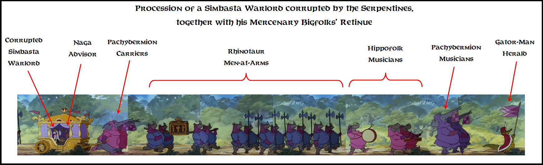
A fan-made Atlas of Arypt Part 6: Settlements and Ruins
Map below shows several settlements and ruins of interest in the region. What is shown is not exhaustive at all, especially if you take into account the scale of the area, as examined in Part 2 of this Atlas. The whole ancient Greece - with all its city-states and culture, history and philosophy, may fit in eastern Cestia.
Several (or many) more settlements and ruins can be added, especially in the empty regions and in the wilderness (Jungle Coast, deserts, etc). Ruins of several Milenian settlements should exist at the fringes of the eastern Jungle Coast and in the Aryptian Savannah. Meghaddarans should have at least a few permanent settlements in their lands, and several ruins of Varellyan cities should dot the route across the Aryptian Basin. The Algarites may have several small settlements along the Aryptian Coast and in the lands of the interior. Perhaps the Katapec built several other crystal pyramids and settlements along the river and elsewhere. The Serpentines may have more than a couple of cities in the jungle, and peculiar outposts, villages and mines should dot the lands of the Bigfolks. Caravansaries, trading posts and small towns with a mixed population should be placed on the cross-continental land route connecting Polakatsikes with Baybluff, and settled oases should exist along the route crossing the Aryptian Basin between Baybluff and Klath'T'zarth. The civilized lands of Cestia should be dotted with towns and villages, and the ruins of Oceanian cities should be more than three (and, perhaps, there might be some inhabited settlement, too).
Consider what is shown in the map below just as a starting point to set several canon and fanon locations for future development.

Comments:
The following list, details settlements and ruins shown in map above, complementing the information already provided in Part 5 of the Atlas (descriptions of races and peole) with local information.
NOTE: Currently just a list of placeholders, to be completed (TBC) at a later time.
- Aegopoli: TBC
- Agarin: TBC
- Amanara: TBC
- Ambastalasha: TBC
- Andazaka: TBC
- Ankavandra: TBC
- Antinal: TBC
- Arazani: TBC
- Arbrenlyaan: TBC
- Arypt: TBC
- Asereht: TBC
- Astylis'Lair: TBC
- Azrad: TBC
- Baghdaan: TBC
- Balfour's Landing: TBC
- Baybluff: TBC
- Beitung: TBC
- The Boulder Clan: TBC
- Caducea: TBC
- Caerdwicca: TBC
- Carack: TBC
- Cathos: TBC
- Crossroads: TBC
- Dorylene: TBC
- Drosonai: TBC
- Dubbo: TBC
- Fort Ballarat: TBC
- Gades: TBC
- Galgaboth: TBC
- Garth: TBC
- Gorias: TBC
- Greatwall: TBC
- Hargast: TBC
- Henkus' Obelisk: TBC
- Ilsundyl's Gate: TBC
- Iossa: TBC
- Ishtura-Koth: TBC
- Ivory City: TBC
- Jalinas: TBC
- Kart-Hadasht: TBC
- Keep of Khest: TBC
- Kechamar: TBC
- Kerynos: TBC
- Klath'T'Zarth: TBC
- Kolosson: TBC
- The Lost City: TBC
- Mahajanga: TBC
- Manacapuru: TBC
- Matirako: TBC
- Mecenis: TBC
- Milenia (aka Milenopolis): TBC
- Mogador: TBC
- Moreus: TBC
- Nandua: TBC
- The Needle: TBC
- Neo Arypt: TBC
- Nevumm: TBC
- Nu-Ilarnn: TBC
- Oceanian Cities #1, #2, #3: TBC
- Odak'Tar: TBC
- Okhirom: TBC
- Orchid Bay: TBC
- Orimul: TBC
- Ouredon: TBC
- P3 - Fortress of Nazir-Al-Azrad: TBC
- P5 - Lair of Apsidar: TBC
- P6 - Lair of Ravellia: TBC
- Peirapolis: TBC
- Pelai: TBC
- Per-Senet: TBC
- Pharos: TBC
- Pirolos: TBC
- Polakatsikes: TBC
- Priallus: TBC
- R1 - Densthen Keep: TBC
- R2 - Exotic dungeon: TBC
- R3 to R9 - Crystal Pyramids: TBC
- Rainbow Park: TBC
- Raven Scarp: TBC
- Samarkand: TBC
- Sasan: TBC
- Schadel: TBC
- Seagirt: TBC
- Serendib: TBC
- Shebal: TBC
- Shemra: TBC
- Shuurit: TBC
- Snarta I: TBC
- Snarta II: TBC
- South Harbor: TBC
- Spearpoint: TBC
- Suur: TBC
- Temple of Ark: TBC
- Tolaira: TBC
- Tsirampany: TBC
- Tulear: TBC
- Vacros: TBC
- Vanya's Rest: TBC
- Varzakh: TBC
- White Flame Rock: TBC
- Whitemount: TBC
- Wyrwatch: TBC
- Xarda: TBC
- Yariin: TBC
A fan-made Atlas of Arypt Part 7: Trade Routes
Trade Routes, general, with hexes:
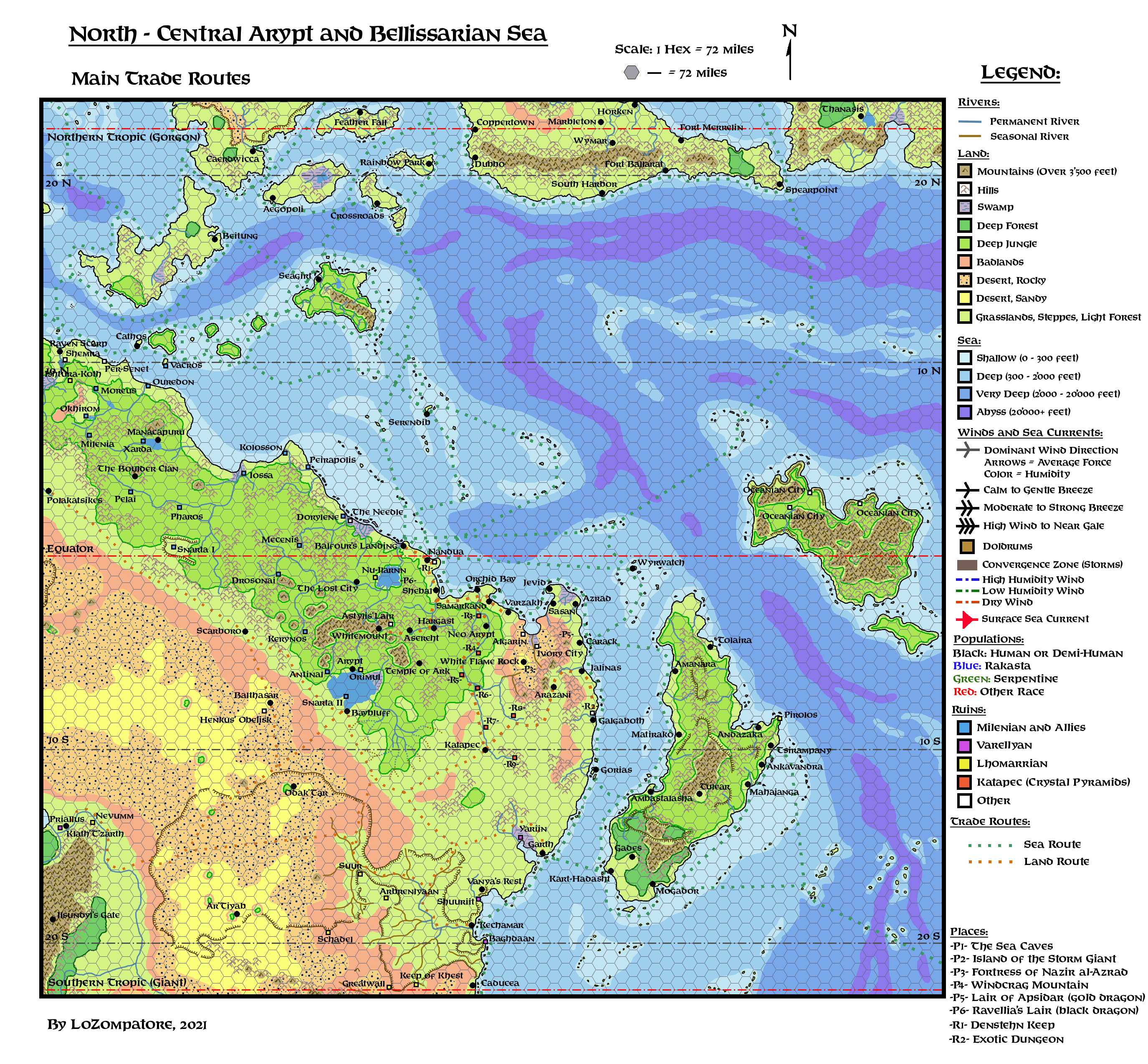
Trade Routes, by main users:
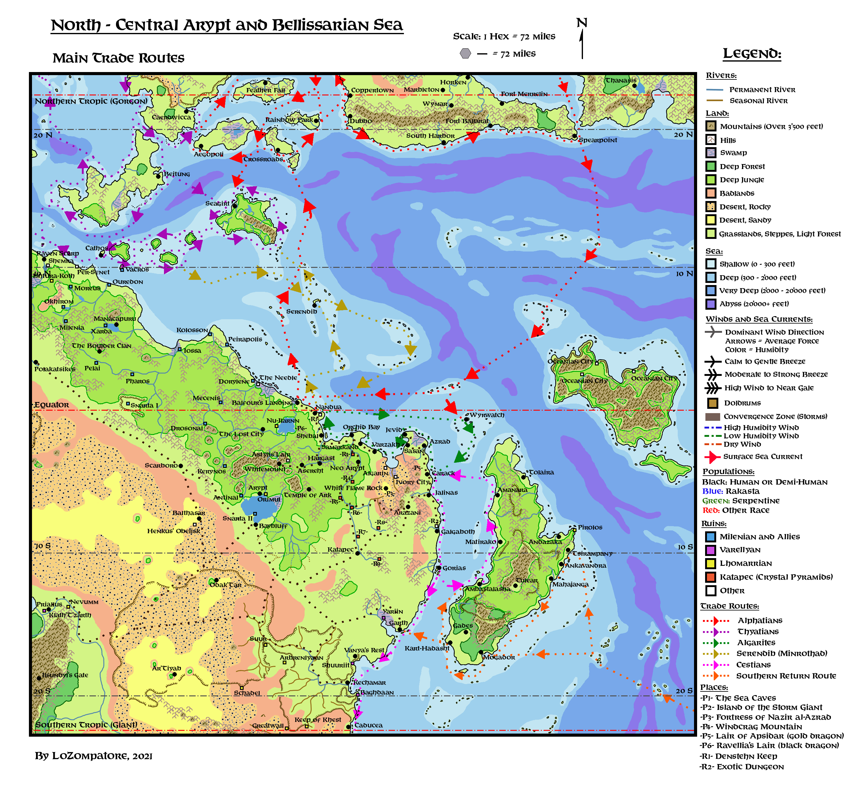
Comments:In principle it is possible for a sailing ship to go anywhere, waiting for a favorable wind to blow in the right direction, or sailing against the dominant winds at the expense of travelling time and route length. So, for this reason, nothing prevents a ship from Spearpoint from coasting Bellissaria and the Alatians up to Beitung and, from there, heading south all along the Jungle Coast to end the trip on the shores of western Oceania. It would require many extra weeks (or months) of travelling, but it is not impossible.
Here below only the easiest and more advantageous travel opportunities are discussed, as they likely will be followed by the majority of merchant ships.
Overall the winds and sea current patterns shown in the figure above highlight the following favorable, speedy sea travel routes:
- Between southern Bellissaria and the central Jungle Coast
- Between the Alatians / Pearl Islands and the northern tip of Davania (Raven Scarp area)
- From the southern tip of Cestia to the north along its western coast
- To Cestia and Oceania from the Vulture Peninsula (off map, to the south and southeast)
Secondary favorable routes form a loop connecting the western coast of Cestia to the eastern coast of Arypt and then to the south along the eastern coast of Davania. There is also the possibility to sail north from the central Jungle Coast to the Pearl Islands, to connect with the route to Ochalea and Raven Scarp.
Notice also that dominant winds and currents favor travelling east across the Strait of Ochalea (from the Western Sea of Dawn to the Pearl Islands), west across the Strait of Milen, south across the Spearpoint Channel and south across the central Alatian Archipelago. Routes from Ochalea and the Alatians help explain the presence of merchants from Alphatia and Minrothad in Seagirt, which is also used by Thyatians as a naval base to monitor sea traffic from the Alatians (DotE page 79).
Details of trading lanes exploited by the major seafaring people of the region - with some insights of the political situation as of AC 1000 - are listed below.
Algarite trade routes:
Algarites are divided into nested, isolated city-states, usually surrounded by unforgiving wilderness; this means that trading (and, sometimes, raiding) among communities is necessary for survival. For the same reason, Algarites are neutral towards all kind of non-hostile vessels reaching their ports, as they believe they cannot afford losing good trading opportunities.
The Doldrums between the Aryptian coast and Cestia make sailing unreliable, so the Algarites specialized on short-range trips between settlements, which are never too far apart in this region. Local sea currents may be exploited instead of winds, creating a clockwise trade loop between Nandua and Carack (and back) with a turning point in the Wyverians. Dozens of small offshore islands are used by short-range ships to resupply and as safe havens by pirates. Spacing between coastal settlements becomes wider along the eastern coast of Davania, south of Galgaboth, where strong winds and sea currents help reaching the southern lands. Settlements in this region tends to be larger and more organized, fielding larger fleets, albeit Jalinas and Galgaboth are usually cut off the main Algarite circuit and are more connected with Cestian traders. In recent times (after AC 965), with the opening of trade between Alphatia and Cestia, traffic along the Pass of Cestia significantly increased thanks to Alphatian convoys. This benefitted Carack and all settlements south of it, especially Galgaboth, which is close to a dangerous but exotic dungeon (see Bock of Wondrous Inventions page 7) often explored by Alphatian mages. Sea travel among Algarite settlements is usually enhanced by human propulsion (galleys and rowers) and by a clever magical contraption described in Dungeon Magazine #50 (page 27). Relevant quote details that the prow of the caliph's dhow "is decorated with a magical figurehead that can run up the sails on command. With this assistance, the ship needs only a small crew". If this enchanted item is not limited to the caliph only but, say, it is accessible also the wealthiest merchants, then the dhows of the Algarites may be able to quickly exploit the tiniest favorable breeze in the Doldrums, thus cutting travelling times. The magic figureheads would be a local development created to face adverse seagoing conditions, which become less useful in nearby bodies of water, where dominant winds are steadier and more reliable.
A note about land routes: The Algarites are among the few in the whole region caring to maintain reliable land routes for their caravans. This is done mostly to increase the list of their suppliers and to bypass the unpredictable sea lanes surrounding the Aryptian coast. More often than not it is more practical to send goods by land, at least for part of the trip, to skip the most troublesome sea routes. While the hostile Algarin Desert is usually avoided, Algarites' merchants do their best to stay in touch with the communities of the interior, most notably Whitemount, Neo Arypt and Katapec. Whitemount is prominent because it provides an important share of the precious minerals, tools and weapons badly needed by the whole region. Neo Arypt is a must for those wishing to put their hands on some rare relic of the ancient Katapec civilization and, finally, the town of (modern) Katapec itself is the gate for any significant trade with the proud Simbasta of the Aryptian savannah. A route option across the settlement of Arazani bypass to the south the Algarite desert, connecting the eastern and western communities of the Aryptian coast. It is a dangerous and winding route but in dire times is used to bring grain and vegetables of the Aryptian Savannah to the Algarite settlements to the northwest.
Alphatian trade routes:
Note: What follows refer to naval Alphatian merchant vessels, usually arranged in slow and bulky convoys with some military escorts. They are dispatched to the southern routes to trade with Alphatian partners in Cestia and in the Green Coast and to resupply the Alphatian colonies of Vulcania (see Book of Wondrous Inventions page 59 for details). Alphatian flying ships are a different matter and they are not forced to follow the routes mentioned below; however, the use of flying ships is restricted to the elite of the Empire and, at any given time, the number of available flying vessels is not large enough to grant a steady flow of goods and supplies. For this reason the Alphatian Empire usually rely upon more traditional vessels to conduct the day-to-day businesses with its Davanian partners.
Traditional Alphatian trading routes in the northern Bellissarian Sea see the Alatian Islands as the main hub between the Isle of Dawn, Bellissaria and the Pearl Islands, with important stops at Crossroads, Rainbow Park and Dubbo on Bellissaria. The western route of the Alatians from Aegos to Thothia, while important, is often plagued by pirates and raiders from Thyatian-aligned Caerdwicca.
With the opening of trade relationships with Cestia in AC 965, the Alphatians resumed an old Milenian sea route which, starting from Spearpoint on Bellissaria, enables to reach the Aryptian coast in relative safety, with stops among the islands of the benign Kunes, which descended from mixes between local populations and ancient Milenian traders. These people, suffering from centuries of isolation, are more than happy to greet Alphatian traders from the north. The only major danger of the area is represented by the shifting Dead Waters, which could trap an entire fleet for weeks, leaving it at the mercy of monsters and evil entities.
Once in the islands of the Brown Kunes it is possible to connect with Algarite and Cestian trade circuits (see) at the Wyverian archipelago, in order to reach the lands of southern Davania and back. The most friendly ports to Alphatian convoys along the southern route are in Carack, Galgaboth, Garth and Caducea, but the last leg south of Garth is threatened by raids from Heldannic warbirds.
The return leg from the Vulture Peninsula is covered under the Cestian trade section. Once back to the Aryptian coast the most convenient route to the Alphatian Empire (i.e. to the Alatians) forces Alphatian convoys to cross part of the sea lanes controlled by Thyatis and Serendib (a proxy of the Minrothad Guilds), and conflicts on these waters are quite common (this is in line with the sentence on page 5 of DotE - Players' Guide to Thyatis about recent squabbles between the Thyatians and Alphatians "in the eastern sea-routes").
For the return trip, the Alphatians established a resupply outpost in Balfour's Landing on the Jungle Coast, Balfour being the name of the Alphatian sea captain who first managed to reach this place two times, on the trip south to Vulcania and back. Here return convoys are repaired and restocked and military escorts assigned to cross the last - and most difficult 2000 miles - stretch up to Crossroads in the Alatians.
Once the relative safety of Balfour's Landing is left, common dangers include pirates' attacks from Nandua, raids from lizardmen war pirogues in the windless shallows of Jungle Coast, skirmishes with Serendib-sponsored privateers and naval battles with regular Thyatian patrols. No surprise that anything arriving in Crossroads from the southern route is expensive, coveted and often smuggled to the best offeror.
Thyatian trade routes:
Thyatians are more concerned with the traditional routes connecting the Isle of Dawn, Ochalea and the Pearl Islands, with the newest addition being the colony of Raven Scarp in AC 990, mostly to secure the Western Sea of Dawn and prevent the Alphatians from establishing their own foothold there. While Ochalea is mostly used by Thyatians as a grain silo and a defensive bastion against Alphatia, the real trade of exotic goods happens in the Pearl Islands; here benign winds and sea currents enable ships to go virtually anywhere in the archipelago.
East of the Pearl Islands the Thyatians traditionally rely upon the merchants of Serendib, a proxy of the Minrothad Guilds.
Following the opening of trade routes between Alphatia, Cestia and southern Davania, the Thyatians engaged in an undeclared war to sink and raid Alphatian convoys climbing from the south towards the Alatians. The usual casus belli is trespassing Thyatian waters in the East Rim Chain, an archipelago of small islands east and south of Nuar, albeit Thyatian warships often extend their "patrols" to the isles north and west of Serendib. These naval skirmishes may well represent the first combat experiences of Helena Daphnotarthius (a future admiral of the Thyatian Navy and future governor of Aegos, see for example PWAII page 126 for her background), possibly following her father during such expeditions.
Serendibian trade routes:
This offshore, semi-independent trading hub of the Minrothad Guild was established around 500 years ago, capitalizing on the first major conflicts between Thyatians and Alphatians, which prevented both empires from expanding in this part of the world. While formally neutral, it is an open secret that Serendib is aligned with Thyatis and its independence lays in keeping a policy of low prices to the Thyatians and in hiring privateers to keep local lanes free of ships undesired by Thyatis.
Serendib merchants control their own trading circuit connected with the Thyatian sea routes in the Pearl Islands. Sailing south from Serendib it is usual for Minrothad traders to touch many of the small islands dotting the waters north of the Aryptian Coast. These islands are tropical paradises full of exotic goods, and the richest were given the name "Boon Islands" since ancient times.
Main port of the Serendib circuit on the Aryptian coast is the city of Nandua, a haven for Pearl Islanders not wishing to conform to the dominant ideology of the archipelago and also a haven for local pirates and smugglers (which are often listed under one of the many Serendib's payrolls). From Nandua it is possible to connect with the Algarite circuit and reach Cestia and southern Davania.
Cestian trade routes:
Albeit contacts between Cestians and Alphatians were established only in AC 965, it does not mean that Cestians do not trade with their neighbors and among themselves.
A very favorable trade circuit starts from Cestian eastern coast; main ports here are the Manakaran city of Ambastalasha and Morovoay's capital of Matirako. From there it is possible to reach the northern settlements of the Aryptian coast, with further possibility to connect with the Algarite circuit. Once in Carack, Cestian ships can find favorable winds and sea currents to sail down the eastern coast of Davania, until the Vulture Peninsula.
Albeit the civilization on the Vulture Peninsula - which as per VotPA was an old trading partner of Cestia - was extinguished in AC 465, this does not prevent trade with other local communities such as Kechamar and Caducea, which are nested in safe anchorages along the Broken Coast. While reefs and hidden rocks along such coast are a danger in itself, the most difficult passage in reaching the Gulf of Mar lays actually in the southern part of the Pass of Cestia (the Tiderips) which is plagued by thunderstorms (see VotPA) and insidious sea currents.
From Caducea there is an advantageous return trip (not shown on the map) along the northern coast of the Vulture Peninsula; once the easternmost point is reached, Alphatian convoys continue south to their colonies and business partners in southern Davania, while most Cestian traders usually turn back home. From the eastern Vulture Peninsula it is possible to cross the western Sea of Steam and - providing the direction is not lost across the Fog Islands -steady winds bring the ships to the fiery volcanic lights of the Lanterns. From there it is possible to reach virtually any point along the southeastern coast of Cestia, thus closing the trade loop. On this coast the Manakaran port of Mahajanga and the Ambiroan cities of Ankavandra and Tsirampany are typical terminal stops for Cestians.
Those wishing to return to the Aryptian coast (including all Alphatian convoys) are usually forced by the Doldrums and by the dangerous night dragons of Oceania to travel around the southernmost tip of Cestia, coasting the erratic kingdom of Androkia. Depending on the mood of its rulers, trading stops are possible at the Androkian capital of Mogador and at the port of Kart-Hadasht.
A most sought destination in this return trip - especially by Alphatians - is the neutral city state of Garth, where it is possible to meet all kind of people from surrounding lands (from the Jungle Coast to the Gulf of Mar to the internal Aryptian Basin) and exchange the most exotic goods and lore from southern Davanian lands with supplies and precious merchandise from the central Aryptian region.
A fan-made Atlas of Arypt Part 8: A possible Adventure Path
In the following I suggest a possible path of official adventures for a party of characters beginning at Level 1 in Serendib and then moving in the region, with the opportunity to explore several of the places I included in the maps.
Selection of Adventures
This campaign is assembled from a set of 32-35 adventures and side quests taken from the following official supplements:
- Adventures and adventures' ideas from D&D Accessories AC3, AC8, AC10 and AC11
- B7 Adventure Module "Rahasia"
- I11 Adventure Module "Needle"
- Dragon Magazine #55 D&D Adventure "The Creature of Rhyl"
- Dungeon Magazine D&D adventures from issues #9, #34, #50, #51, #58
- Dungeon Magazine "generic" AD&D adventures from issues #56, #57, #63, #64, #66, #67, #68, #69, #72, #76, #77, #78, #79, #80, #81. Notice that conversion of Mystara to AD&D happened at the time of issue #48, while any reference to D&D or Mystara is explicitly dropped after issue #62. So I assumed that generic AD&D adventures published after issue #48 could also be used for (AD&D) Mystara. All Dragon Magazine issues after #82 deal with 3rd Edition rules so I did not consider their adventures as suitable choices for this campaign.
- Two AD&D adventures published before Dragon Issue #48 ("Mad Gyoji" of issue #33 and "Serpents of the Sands" of issue #37, respectively) because there are notes about moving them into generic Oriental/Arabic setting and because they fit pretty well into the region.
The abovementioned choices enable the inclusion of several interesting scenarios which can be added to the setting with little modifications.
Notice that I moved from their established locations a few D&D adventures, most notably B7 "Rahasia" and Dungeon Magazine #9 "Djinni's Ring" (which should be heavily modified for a group adventure) because I feel they are a good fit also for this part of Mystara.
I would also place in this region AC3 "The Kidnapping of Princess Arelina" and AC8 "The Revenge of Rusak", albeit I know that there is an established fanon location for both of them west of the Icereach Mountains in central Brun (see GAZ F5 "The Western Alliance" for details).
Considering that a party of characters adventuring in Arypt will unlikely reach the continent of Brun before Companion or Master levels, such a party will not likely have the opportuniy to play B7, AC3 and AC8 in their original locations. So I don't think there would be much interference with the progress of a broader campaign if the abovementioned adventures are played on Davania.
Campaign Description
This campaign is ideally conceived to bring a party of adventurers through the turmoil affceting Northern Arypt and the Eastern Jungle Coast in the 15 years between AC 984 and AC 999.
In this timeframe the PCs should gain approx. 1 BECMI experience level per year, being involved into an average of two adventures / side quests per year. By AC 999 the party should be around BECMI level 14, standing at the threshold of Companion Level adventures.
I made an attempt to connect the adventures in a (hopefully not too much railroading) flow chart, as shown below. Of course this is just one of the myriad of possible combinations coming from the choices of the players during the campaign, but I believe that such a reference chart may be useful for a DM wishing to get a clue on how to arrange the set of adventures.
After all "while in battle, plans are useless but planning is mandatory".
The adventures may be played as separate quests, or they can be connected through "Adventure Archs", highlighted by identical colors in the flow chart below. A DM may link together the adventures that are part of the same Arch, by assuming that one of the Movers and Shakers of the campaing is behind the events of all of them. For details see the "Movers and Shakers" section below. Not all the Adventure Archs need to be exploited in the same campaign and some of them can easily be dropped in favour of more light-hearted, one-shot adventures.
All the Adventure Archs are intentionally not completed, to give room for a DM to expand on them and create its own adventures after the end of this campagin, assuming the PCs decide to stay in this part of the world. For example, as the right time for the Night of the Venom approaches, the Yuan-ti will intensify their subtle efforts to unify the Serpentine Empire, until their armies are strong enough to conquer all nearby communities in a devastating war.
As a final option, the last quests of the campaign (a series of adventures centerd on The Needle and the standoff detailed in "The Revenge of Rusak") should heavily embroil the PCs in the broader struggle for power between Thyatis, Alphatia and the Heldannic Knights, possibly leading them out of Davania to take part to the events of the Known World during DotE and WotI.

Placement of all adventures in the general map is shown below:
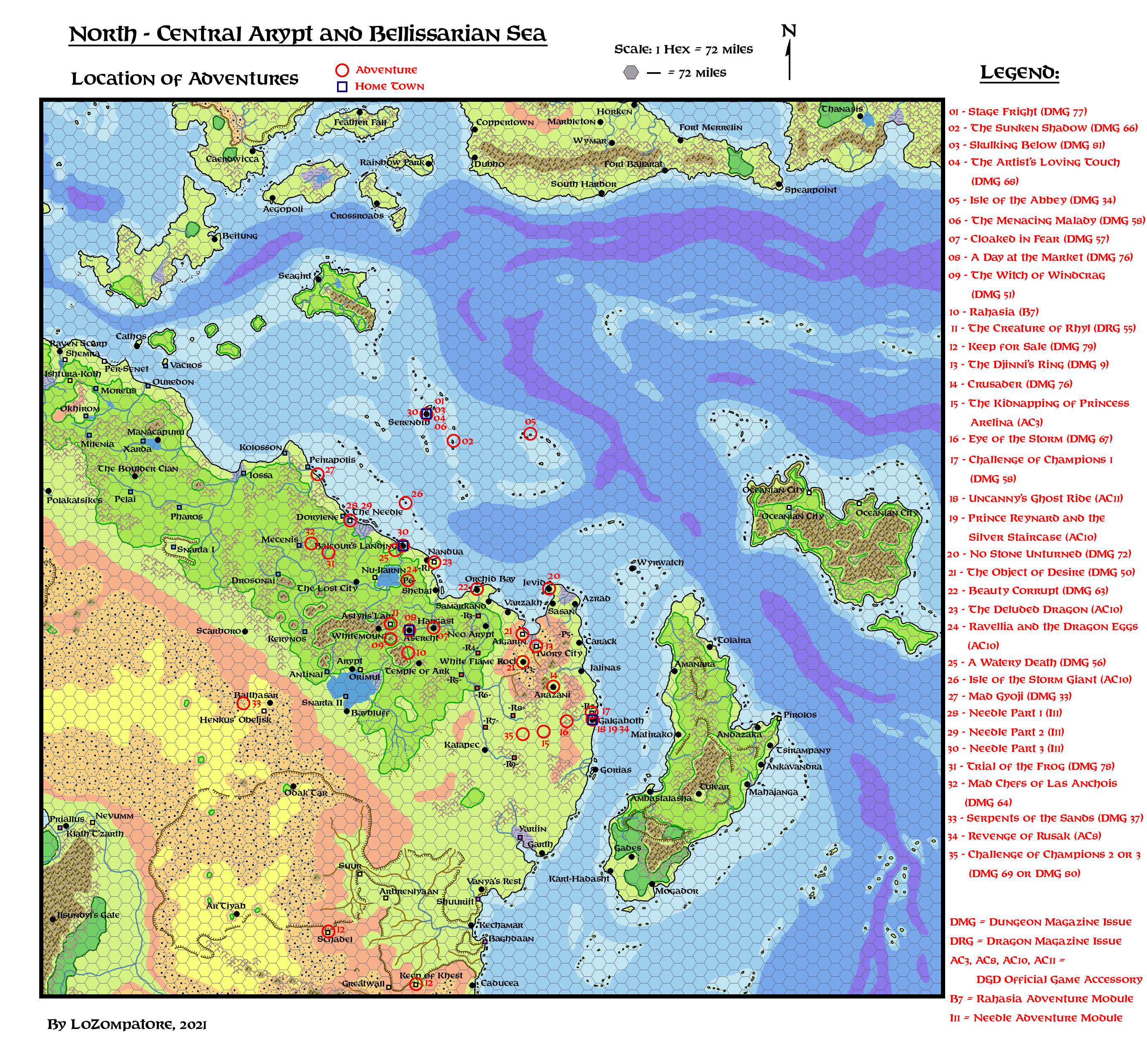
Movers and Shakers of the Aryptian Campaign:
Thyatians are not directly involved in this campaign, as they take care of their interests in the area through their proxy represented by the Merchant Guilds of Serendib.
The other factions active at the time of PCs involvement are detailed below.
Algarites:
Related Adventures:
The Djinni's Ring (adapted) (Dungeon Magazine #9)
The Object of Desire (Dungeon Magazine #50)
Beauty Corrupt (Dungeon Magazine #63)
The Deluded Dragon (AC10 Module)
Following the arrival of the Alphatians to the coast shortly after AC 965, the city states of the Algarites saw a big increase in trade and wealth, but they also found themselves too weak and fragmented against such a strong competitor. Growing Heldannic Knights' influence in the Aryptian Savannah is also seen with suspicion, while the Yuan-ti menace is negligently underestimated.
Most Algarite rulers believe that, should Serendib (and the Thyatians backing Serendib's Merchant Guilds) lose control of the sea routes, then the Alphatians could have free reins along the Aryptian coast, putting an end to the independance of all Algarites' city states. For these reasons, a surge of diplomatic activity is currently sweeping through the coast, as all settlements look for new allies or renew older agreements. Sasan and Samarkand are planning a dynastic marriage in the hope of restoring the bulk of the ancient Sultanate of Algarin, a union that hopefully would attract neighbouring settlements too. The oligarchy of Orchid Bay is looking for an alliance with the military-oriented Wyverians, offering food and goods in exchange for weapons and mercenaries. The people of Galgaboth are trying to turn their lands in a true neutral ground, where champions from other countries may periodically meet in challenges of honour, bringing wealth to the town and keeping invaders at bay through the equilibrium of forces so established.
The Algarites of Rhyl mostly wish to keep local land routes open, as the road network connecting the kingdom with the coast and with their demi-human allies (the dwarves of Whitemount and the elves to the south) is their only possibility to keep their economy working. The people of Rhyl still does not suspect of the re-awakening of the Serpentines and believes that all accidents happening in their surroundings are due to the actions of indivdual creatures.
Alphatians:
Related Adventures:
A Watery Death (Dungeon Magazine #56)
Mad Gyoji (Dungeon Magazine #33)
Needle Part 1 (I11 Module)
Needle Part 2 (I11 Module)
Trial of the Frog (Dungeon Magazine #78)
Mad Chefs of Las Anchois (Dungeon Magazine #64)
Needle Part 3 (I11 Module)
Serpents of the Sands (Dungeon Magazine #37)
As detailed in previous Part 7, the Alphatians have a foothold on the Aryptian Coast through their puppet "kingdom" of Balfour's Landing. They wish to make the colony as strong as possible in order to support their long-range trades; if in the process they also manage to seize some other local settlements along the Coast, the better. This is unacceptable for the Thyatians, unwelcome by the Merchants of Serendib and looked with suspicion by the Algarites. Moreover, the chaotic society of the Alphatians already spilled far from Balfour's Landing, creating havoc in surrounding territories. Ambitious Alphatian nobles (i.e. powerful magic users) moved in the new, exotic lands from Alphatian-controlled territory and dispersed, loyal only to themselves and following their own personal goals. These uncaring personalities altered more than one balance of power, and disturbed entities that should be better left alone. Three examples are detailed in this campaign: Porthratos the Air Elementalist (see below for details) who treacherously seeds terror and destruction to seize the town of Galgaboth for himself; the three mages Randal Willhandle, Wendall Willendall and Stendhall Willendall, who are obsessed with dragon eggs for their experiments; the giants of Las Anchois, who moved from Limn to the Jungle Coast to establish their own community of "gourmets", at the expense of most of the living beings of the surroundings.
The ruler ("king") of Balfour's Landing - and the powerful Alphatian mages who back him - are very interested in the powers of the Needle, as its force field may shield the most critical parts of the settlement against external threats, so they are planning a major expedition to the coast to seize it. As the most direct searoute to the north is blocked by the raiding parties of the lizardmen, the Alphatians plan to make contact with one of the coastal settlements of the Yasuko (who are believed to share some ancient Alphatian blood in their veins), gain their friendship and use that place as an intermediate base to bypass the dangerous Hunting Shoals when it is time to retrieve the obelisk.
The Evil from the Deep:
Related Adventures:
The Sunken Shadow (Dungeon Magazine #66)
Beauty Corrupt (Dungeon Magazine #63)
AC10 Adventure: Isle of the Storm Giant
The Evil from the Deep is a powerful lich living somewhere at the bottom of the Bellissarian Sea. His main interest is to create as much havoc and chaos as possible through his actions. The lich is also known as "The Gifter" as he is known to send misleading advices and subtly cursed magical items to those who intrigue his wicked personality. His minions (assuming they are actually minions and not mere pawns) are not immune to his "gifts". During this campaign the PCs have three opportunities to witness first-hand the lich's misdeeds:
1) The Gifter gave notorious pirate queen Kirella Shadowgate the cursed Golden Eel Armband, which increased her greed to an insane level and led to a dramatic spike in pirates' activities. The Armband's power also led to the fall of Arkos Seatamer and Derek Harpwind, the two greatest champions of Serendib against pirates.
2) The lich gifted the three hags Zityak, Groutle and Prout with the recipe of eternal beauty; their quest for the foolish ingredients of the recipe led to the fall of several good beings and created havoc throughouth the Aryptian Coast for more than five decades. Now that the recipe is close to completion the hags were forced to get closer to human lands. They were discovered by one of the leaders of Orchid Bay and, to cover their actions, inflicted on him a magical dementia, just while he was to sign a major treaty with a nearby country.
3) The Gifter sent an aquatic beholder in the lair of a powerful storm giant, which was taken by surprise and charmed by the beholder with dreams of wealth beyond limits. The storm giant moved to an island in the middle of the most crossed sea lanes and started plundering all merchant vessels passing nearby.
It is unknown if the lich has a superior purpose other than spreading chaos. It might be his own way to get some fun from the world, or it could be part of his Path for Immortality for an unknown sponsor.
Heldannic Knights:
Related Adventures:
Crusader (Dungeon Magazine #76)
The Kidnapping of Princess Arelina (AC 3 Module)
Revenge of Rusak (AC 8 Module)
The Heldannic Knights established their mighty fortress at Vanya's Rest between AC 952 and AC 958, following a holy quest they started in AC 941. Unfortunaltely, the fortress is surrounded by large prides of hostile Simbasta so the Knights are looking for at least another, safer base of operations in Northern Arypt, to provide support to Vanya's Rest and prevent its conquest by foreign hands.
The Knights of the initial quest tried to establish an outpost in Densthen Keep around AC 943, but they were treacherously attacked by pirates from Nandua, suffered heavy losses and were forced to abandon the place. Learning from this downturn, the Heldannic Knights set in motion a more devious plan to seize at least one of the city-states for themselves.
At first, selfless, heroic Heldannic paladins were dispatched from Vanya's Rest with orders to roam the Aryptian Savannah and right all the wrongs they could see among human and demi-human communities, asking for nothing in return. These idealistic and noble knights were actually manipulated by their leaders to show how good and trustful the Order was, so to give a lasting positive impression in local people. Several of these paladins still live in the region, beloved by the peasants and apparently oblivious of the larger schemes around then.
Then, in the most welcoming communities, more sinister members of the Knights were sent, acting as wisemen and counselors. They did not interfere with everyday life but did their best to manipulate local rulers (or their courts) in favour of the Heldannic Knights. They asked for permission to build temples of Vanya in or around the towns and to include a "token" garrison to protect the holy places. In the meantime they looked for potential allies and established their own network of agents and spies to gather intelligence about the weak spots of local communities.
By the time the PCs are involved in the campaign, the Heldannic Knights - pressed by the attempts of Porthratos the Air Elementalist to establish his own Alphatian-aligned dominion in Galgaboth - are ready to seize the kingdom of King Limakhan. The Knights first act trough one of their proxies, the scheming mage Rusak, to kidnap the daughter of king Limakhan. This is just a ruse to instill fear in the king and to persuade him to accept a large garrison of knights in his castle to protect the royal family. A few years later Ziegler, the Heldannic Warden of the Garrison, finally set things in motion by killing King Limakhan and giving his daughter to a vengeful Rusak to be used as a bait for the PCs. The involvement of the PCs in this coup d'etat marks the ideal end of the campaign and the PCs' direct involvement in the struggle among major powers that would lead to WotI.
Merchants of Serendib:
Related Adventures:
The Sunken Shadow (Dungeon Magazine #66)
Skulking Below (Dungeon Magazine #81)
The Artist's Loving Touch (Dungeon Magazine #68)
Stage Fright (Dungeon Magazine #77)
Isle of the Abbey (Dungeon Magazine #34)
AC10 Adventure: Isle of the Storm Giant
Needle Part 1 (I11 Module)
Needle Part 2 (I11 Module)
Trial of the Frog (Dungeon Magazine #78)
Mad Chefs of Las Anchois (Dungeon Magazine #64)
Needle Part 3 (I11 Module)
Those in charge at Serendib are mostly interested in keeping the status quo as, apparently, reverting everything back to AC 950, when the Alphatians and the Heldannic Knights were nothing but faraway names, is impossible. Serendib is very rich and civilized, but it lacks manpower, large food supplies and mineral wealth; its independance is tolerated by the Thyatians only thanks to the favourable trade agreements established centuries ago. Should the trade routes to the Aryptian Coast falter, or be dominated by strong competitors such as the Alphatians or the unified Algarites, then the golden age of Serendib would surely be over.
The Merchant Guilds are well aware of this, and try to increase their influence at any possible opportunity, encouraging corsairs' actions against the Alphatians and trying at the same time to keep the sea lanes free for their ships to use. Unfortunately, a series of downturns plague the city right at the beginning of the campaign. Some of them are definitely caused by interference by the Osani (see related entry); others seems nothing more than random incidents but, maybe, they are part of larger schemes by other external powers like the Alphatians or the Evil from the Deep.
The rulers of Serendib are very interested in the powers of the Needle, as its force field may shield the port and the government buildings from external attacks, so they are planning a major expedition to the coast to seize it. In case they succeed the Merchants of Serendib will also feel more protected also against the Thyatians: they would rise prices for luxury items and would not fear so much the effects of their retaliation.
The Osani:
Related Adventures:
Skulking Below (Dungeon Magazine #81)
Isle of the Abbey (Dungeon Magazine #34)
The Menacing Malady (Dungeon Magazine #58)
No Stone Unturned (Dungeon Magazine #72)
As described in Dungeon Magazine #72 ("No Stone Unturned" adventure) the Osani are an expansionist organization of Lawful Evil individuals belonging to various races. They revere Onadar, Lord of the Dead, which could well be another name for Thanatos, Hel or Nyx. They have very long-term goals, planning a slow infiltration in all major communities of the Aryptian Coast until they are ready to seize the whole land in a single, orchestrated revolt, establishing their own, evil Empire of Onadar. During the campaign the Osani are still a hidden power, with possible contact and allies among the most evil Heldannic Knights and among the minions of the Evil of the Deep. They avoid the Serpentine Empire due to conflicting agendas about the region (often the Osani and the Yuan-ti plot against each other) while they plan to manipulate the newcomer Alphatians to their scopes until they will finally be expelled from the region.
Currently the Osani are on the defensive, as the Merchant Princes are planning to cleanse their archipelago from their influence through the use of proxies (pirates, corsairs, and the PCs). As a retaliation the Osani spread a deadly plague in Serendib through their sleeping agents. During their travelling along the Aryptian Coast the PCs have the opportunity to clear a large Osani hidehout in Jevid, an action which will make them sworn enemies of the organization.
The location of Osanis' headquartes is unknown, and the true power and extent of their organization is still to be assessed. In case the PCs decide to stay in the Aryptian region after the end of the campaign, the Osani might become the hidden puppeteer behind most of the troubles the party would incur, plotting at the same time with other Movers to accelerate the demise of the Algarites, of the Merchants of Serendib and of the Alphatians.
Porthratos the Air Elementalist:
Related Adventures:
Eye of the Storm (Dungeon Magazine #67)
Adventure Idea from The Sultan's Uncanny Ghost Ride (AC 11 Module)
Prince Reynard and the Silver Staircase (AC 10 Module)
Porthratos is a splinter gone mad of the Alphatians. He is a powerful Air Elementalist who left Balfour's Landing with a very clear obsession in his mind: to carve a dominion for himself along the Aryptian Coast to show the whole Empire his talent. Unfortunately, he is quite skilled in his job and he managed to subdue a clan of Cloud Giants and a pack of Thunder Children (see Dungeon Magazine #67), forcing them to share the clouds of the giants' floating island. Currently Porthratos aims to seize the town of Galgaboth, lured by its silver mines, its good location along the Aryptian Savannah, and intrigued by the exotic dungeon nearby which is used by local people for the Challenge of Champions. The methods used by Porthratos to reach his scope are utterly despicable: he poses as a friendly salesman of lightning rods, only to unleash the full power of the Thunder Children over the unfortunate communities he visits. He is travelling all around Galgaboth, trying to spread terror and major damage to roads, bridges and supply lines, effectively putting the town under siege. He also modified an ancient magical contraption owned by local gypsies, an entertainment contrivance called the "Ghost Ride of Sultan Jalinas". His modifications enable him to kidnap kids while inside the Ride, moving them to a prison in the clouds of the flying castle. There he plans to brainwash and hypnotize the kids, to use them as his "army" to gain access to the most critical buildings of Galgaboth. In a final move, Portrathos tricked the young Prince Reynard, the son of Galgaboth's king Thales, into climbing a magical staircase which directly led to the Cloud Giants' castle, where the young heir was imprisoned. A brainwashing of Prince Reynard would grant Porthratos free access to the king's private rooms, just a murder away from becoming the next king of Galgaboth.
Yuan-ti of the Serpentine Empire:
Related Adventures:
Cloaked in Fear (Dungeon Magazine #57)
The Creature of Rhyl (Dragon Magazine #55)
The Witch of Windcrag (Dungeon Magazine #51)
Rahasia (B7 Module)
Keep for Sale (Dungeon Magazine #79)
Needle Part 3 (I11 Module)
Serpents of the Sands (Dungeon Magazine #37)
The Yuan-ti have grand plans for the rebirth of their Serpentine Empire during the events of the campaign. They are aware that the Night of the Venom (see Dungeon Magazine #37 pages 11 and 16) is approaching; a suitable ceremony performed during the Night will turn a large number of human and demi-human prisoners into an army of mutant creatures devoted to the Serpentines. At the same time, the Yuan-ti are planning to isolate the dwarves of Whitemount and the kingdom of Rhyl, where most of the weapons and metal tools of the Aryptian Coast are forged and traded. This will be done by:
1) interrupting the trade route across the valley of Windcrag Mountain (thus separating Whitemount and Rhyl);
2) spreading terror on Asereht and kidnapping the local Prince with a summoned white dragon in the Far Mountains;
3) reawakening the three Lhomarrian evil witches Karalena, Solorena and Trilena tanks to the intervention of their brother, the Rahib, who will be summoned from the past through a time gate.
By conquering the two isolated communities one at a time the Yuan-ti will be able to remove the most direct menace to the heart of the Serpentine Empire and to provide with weapons and armors the Army of the Venom they are planning to create. Most of the "raw living material" for the Night of the Venom will come from the divided human nomads living between Lake Arypt and the lands of the Sis-thiks. For this reason, an alliance with the local serpents of the sands is mandatory.
The first target of the Army of the Venom will be the tribes of Pardasta separating the Sis-thiks from the bulk of the Serpentine Empire. Once the encroachement of the rakasta around the Serpentine Empire is broken, the Yuan-ti will then play another trick: they are going to invade the planar spider's outpost of Chak on Matera, then use the teleporting obelisks to outmaneuver the rakasta and the human communities, leading their Army of the Venom directly on their enemies' weakest points. The Yuan-ti have a powerful agent among the Black Chack of Matera, a blue dragon called Henkus who, decades ago, managed to activate the obelisk in the Avera Desert and, feigning loyalty to the planar spiders, learned enough on how the magical portals work. The missing piece of information he needs is just how to open a portal from Chak to a given obelisk on Mystara, something he will learn when the PCs are brought back home at the end of the third part of "Needle" adventure. Henkus will modify the destination of the magical gate to open the obelisk of the Avera Desert instead of the one in the lands of the Grippli. Henkus will then fly to his Yuan-ti masters in the desert to report on his discoveries.
In short, if left unchecked, the Yuan-ti will be able to regroup the forces of the Serpentines, build a powerful army of brainwashed mutated slaves, and seize a powerful teleporting network able to move such an army across the Aryptian coast and elsewhere, greatly enlarging the extent and the power of the reborn Serpentine Empire.
A fan-made Atlas of Arypt Part 9: Notes and Details about Campaign Adventures
Placeholder for notes and details of all campaign adventures